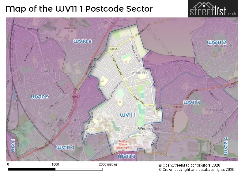
The WV11 1 postcode sector stands on the Staffordshire and West Midlands border.
Did you know? According to the 2021 Census, the WV11 1 postcode sector is home to a bustling 12,051 residents!
Given that each sector allows for 400 unique postcode combinations. Letters C, I, K, M, O and V are not allowed in the last two letters of a postcode. With 223 postcodes already in use, this leaves 177 units available.
The largest settlements in the WV11 1 postal code are WOLVERHAMPTON and Wednesfield.
The WV11 1 Postcode shares a border with WV10 0 (WOLVERHAMPTON, Heath Town), WV10 8 (WOLVERHAMPTON, Wednesfield, Westcroft), WV11 3 (WOLVERHAMPTON, Wednesfield), WV11 2 (WOLVERHAMPTON, Essington, Wednesfield) and WV13 3 (WILLENHALL).
The sector is within the post town of WOLVERHAMPTON.
WV11 1 is a postcode sector within the WV11 postcode district which is within the WV Wolverhampton postcode area.
The Royal Mail delivery office for the WV11 1 postal sector is the Wolverhampton Ne Delivery Office.
The area of the WV11 1 postcode sector is 1.12 square miles which is 2.91 square kilometres or 718.10 square acres.
Waterways within the WV11 1 postcode sector include the Wyrley and Essington Canal.

Map of the WV11 1 Postcode Sector
Explore the WV11 1 postcode sector by using our free interactive map.
| W | V | 1 | 1 | - | 1 | X | X |
| W | V | 1 | 1 | Space | 1 | Letter | Letter |
Official List of Streets
WOLVERHAMPTON (92 Streets)
Wednesfield (16 Streets)
Unofficial Streets or Alternative Spellings
WILLENHALL,
LICHFIELD ROAD NEACHELLS LANEWOLVERHAMPTON
BUSHBURY ROAD CORONATION ROAD LEWIS GROVE LONGFORD ROAD MATTOX ROAD MILTON ROAD MOATHOUSE LANE WEST SIDINGS CLOSE THORNEYCROFT LANE WEDNESFIELD WAYHeath Town
CHURCH STREET LAWRENCE AVENUE WOLVERHAMPTON ROADFallings Park
CANNOCK ROAD BACKHOUSE LANE BEALEYS FOLD CEDAR WAY DEYNCOURT ROAD MILL CLOSE NEW CROSS AVENUE NICHOLLS FOLD WOODHOUSE FOLDSchools and Places of Education Within the WV11 1 Postcode Sector
Deyncourt Primary School
Academy converter
Mullett Road, Wolverhampton, West Midlands, WV11 1DD
Head: Mrs D Darby
Ofsted Rating: Good
Inspection: 2022-06-22 (701 days ago)
Website: Visit Deyncourt Primary School Website
Phone: 01902558778
Number of Pupils: 310
Heath Park
Academy converter
Prestwood Road, Wolverhampton, West Midlands, WV11 1RD
Head: Mrs Georgetta Holloway
Ofsted Rating: Outstanding
Inspection: 2014-02-27 (3738 days ago)
Website: Visit Heath Park Website
Phone: 01902556360
Number of Pupils: 1173
Long Knowle Primary School
Community school
Blackwood Avenue, Wolverhampton, West Midlands, WV11 1EB
Head: Mrs Julie Bond
Ofsted Rating: Good
Inspection: 2019-11-27 (1639 days ago)
Website: Visit Long Knowle Primary School Website
Phone: 01902558985
Number of Pupils: 230
Wodensfield Primary School
Community school
Woden Avenue, Wolverhampton, West Midlands, WV11 1PW
Head: Mrs Samantha Walker
Ofsted Rating: Good
Inspection: 2019-03-05 (1906 days ago)
Website: Visit Wodensfield Primary School Website
Phone: 01902556350
Number of Pupils: 472
Wood End Primary School
Community school
Wood End Road, Wolverhampton, West Midlands, WV11 1YQ
Head: Miss Sonia Sharma
Ofsted Rating: Good
Inspection: 2019-12-11 (1625 days ago)
Website: Visit Wood End Primary School Website
Phone: 01902558940
Number of Pupils: 248
House Prices in the WV11 1 Postcode Sector
| Type of Property | 2018 Average | 2018 Sales | 2017 Average | 2017 Sales | 2016 Average | 2016 Sales | 2015 Average | 2015 Sales |
|---|---|---|---|---|---|---|---|---|
| Detached | £207,363 | 22 | £284,445 | 19 | £253,235 | 24 | £210,390 | 21 |
| Semi-Detached | £146,269 | 86 | £138,330 | 86 | £132,411 | 80 | £117,619 | 64 |
| Terraced | £129,058 | 33 | £117,452 | 41 | £112,500 | 21 | £98,967 | 23 |
| Flats | £55,576 | 13 | £59,536 | 22 | £67,824 | 17 | £53,495 | 10 |
Important Postcodes WV11 1 in the Postcode Sector
WV11 1DD is the postcode for Deyncourt Primary School, Mullett Road, and Deyncourt Cp School, Mullett Road
WV11 1EB is the postcode for Long Knowle Primary School, Blackwood Avenue
WV11 1HT is the postcode for Doctors Surgery, 81 Prestwood Road West
WV11 1NN is the postcode for SCHOOL, Braybrook Centre, Bellamy Lane
WV11 1PE is the postcode for The Childrens Village, Graiseley Lane
WV11 1PG is the postcode for St. Patricks Catholic Primary Academy, Graiseley Lane, and St. Patricks Primary School, Graiseley Lane
WV11 1PW is the postcode for WODENSFIELD PRIMARY SCHOOL (JUNIORS), Wodensfield Primary School, Woden Avenue, WODENSFIELD (JUNIOR) PRIMARY SCHOOL WODEN AVENUE JUNIOR & INFANT SCHOOL, Wodensfield Primary School, Woden Avenue, WODENSFIELD (INFANTS & NURSERY) PRIMARY SCHOOL WODEN AVENUE JUNIOR & INFANT SCHOOL, Wodensfield Primary School, Woden Avenue, and WODENSFIELD PRIMARY SCHOOL (INFANTS & NURSERY), Wodensfield Primary School, Woden Avenue
WV11 1RD is the postcode for A BLOCK, Heath Park Academy School, Prestwood Road, Main Block, Heath Park Academy School, Prestwood Road, ARTS BLOCK, Heath Park Academy School, Prestwood Road, B BLOCK, Heath Park Academy School, Prestwood Road, Heath Park Academy School, Prestwood Road, and Sports Hall, Heath Park Academy School, Prestwood Road
WV11 1SF is the postcode for Woden Community Resource Centre, Vicarage Road
WV11 1XU is the postcode for Wednesfield Housing Office, Alfred Squire Road, Alfred Squire Health Clinic, Alfred Squire Road, and Police Station, Alfred Squire Road
WV11 1YG is the postcode for Long Knowle Community Hub, Wood End Road
| The WV11 1 Sector is within these Local Authorities |
|
|---|---|
| The WV11 1 Sector is within these Counties |
|
| The WV11 1 Sector is within these Water Company Areas |
|