The B12 0 postcode sector is within the county of West Midlands.
Did you know? According to the 2021 Census, the B12 0 postcode sector is home to a bustling 4,842 residents!
Given that each sector allows for 400 unique postcode combinations. Letters C, I, K, M, O and V are not allowed in the last two letters of a postcode. With 152 postcodes already in use, this leaves 248 units available.
The largest settlement in the B12 0 postal code is BIRMINGHAM followed by Deritend, and Bordesley.
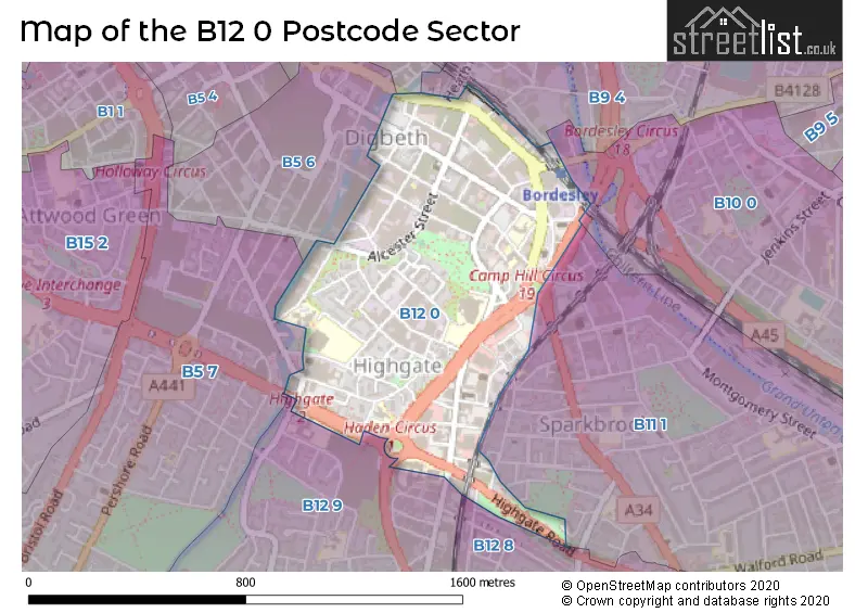
The B12 0 Postcode shares a border with B5 5 (BIRMINGHAM), B5 6 (BIRMINGHAM), B9 4 (BIRMINGHAM, Bordesley, Bordesley Green), B11 1 (BIRMINGHAM, Sparkhill, Sparkbrook), B5 7 (BIRMINGHAM, Edgbaston), B10 0 (BIRMINGHAM, Small Heath), B12 8 (BIRMINGHAM, Balsall Heath, Sparkbrook) and B12 9 (BIRMINGHAM, Balsall Heath).
The sector is within the post town of BIRMINGHAM.
B12 0 is a postcode sector within the B1 postcode district which is within the B Birmingham postcode area.
The Royal Mail delivery office for the B12 0 postal sector is the unknown.
The area of the B12 0 postcode sector is 0.41 square miles which is 1.06 square kilometres or 262.20 square acres.
Waterways within the B12 0 postcode sector include the River Rea.

Map of the B12 0 Postcode Sector
Explore the B12 0 postcode sector by using our free interactive map.
| B | 1 | 2 | - | 0 | X | X |
| B | 1 | 2 | Space | 0 | Letter | Letter |
Official List of Streets
BIRMINGHAM (56 Streets)
Deritend (3 Streets)
Bordesley (1 Streets)
Sparkbrook (1 Streets)
Unofficial Streets or Alternative Spellings
Bickenhill
COVENTRY ROADBIRMINGHAM
ADDERLEY STREET CAMP HILL GIBB STREET GOOCH STREET HADEN WAY HEATH MILL LANE KYRWICKS LANE LONGMORE STREET MACDONALD STREET TURNER STREET UPPER TRINITY STREET BEDFORD ROAD BELGRAVE ROAD BORDESLEY MIDDLEWAY BROOM STREET CAMP HILL CIRCUS CAMP HILL MIDDLEWAY CHANDOS ROAD CHAPEL HOUSE STREET CLISSOLD CLOSE HADEN CIRCUS HANWOOD CLOSE HIGH STREET BORDESLEY HIGH STREET DERITEND LOWER DARWIN STREET STONE YARD TRINITY TERRACESparkbrook
HIGHGATE ROAD TIMBERS WAYBalsall Heath
WOODFIELD ROADSchools and Places of Education Within the B12 0 Postcode Sector
Ark St Alban's Academy
Academy sponsor led
Conybere Street, Birmingham, West Midlands, B12 0YH
Head: Mr Guy Rimmer
Ofsted Rating: Requires improvement
Inspection: 2021-11-24 (924 days ago)
Website: Visit Ark St Alban's Academy Website
Phone: 01214461300
Number of Pupils: 901
Calthorpe Academy
Academy special converter
Darwin Street, Birmingham, West Midlands, B12 0TP
Head: Mr Mounir Meghalsi
Ofsted Rating: Good
Inspection: 2023-10-05 (244 days ago)
Website: Visit Calthorpe Academy Website
Phone: 01217734637
Number of Pupils: 428
Chandos Primary School
Academy sponsor led
Vaughton Street South, Birmingham, West Midlands, B12 0YN
Head: Mrs Debbie Norbury
Ofsted Rating: Good
Inspection: 2019-02-27 (1925 days ago)
Website: Visit Chandos Primary School Website
Phone: 01214643881
Number of Pupils: 469
Harper Bell Seventh-day Adventist School
Voluntary aided school
29 Ravenhurst Street, Birmingham, West Midlands, B12 0EJ
Head: Ms Mary Collette Woodburn
Ofsted Rating: Good
Inspection: 2019-07-17 (1785 days ago)
Website: Visit Harper Bell Seventh-day Adventist School Website
Phone: 01216937742
Number of Pupils: 179
Heritage Academy
Other independent school
327 Moseley Road, , , B12 0DX
Head: Mr Shakeel Akhtar
Ofsted Rating: Outstanding
Inspection: 2023-10-19 (230 days ago)
Website: Visit Heritage Academy Website
Phone: 01214402222
Number of Pupils: 56
St Anne's Catholic Primary School
Voluntary aided school
Lowe Street, Birmingham, West Midlands, B12 0ER
Head: Mr Wendell Gopaul
Ofsted Rating: Good
Inspection: 2019-06-05 (1827 days ago)
Website: Visit St Anne's Catholic Primary School Website
Phone: 01216755037
Number of Pupils: 204
House Prices in the B12 0 Postcode Sector
| Type of Property | 2018 Average | 2018 Sales | 2017 Average | 2017 Sales | 2016 Average | 2016 Sales | 2015 Average | 2015 Sales |
|---|---|---|---|---|---|---|---|---|
| Detached | £855,000 | 1 | £0 | 0 | £576,000 | 1 | £0 | 0 |
| Semi-Detached | £130,000 | 1 | £199,000 | 1 | £0 | 0 | £141,650 | 3 |
| Terraced | £155,000 | 2 | £143,000 | 6 | £123,667 | 3 | £127,208 | 12 |
| Flats | £122,920 | 217 | £130,532 | 159 | £131,856 | 38 | £122,332 | 22 |
Important Postcodes B12 0 in the Postcode Sector
B12 0DG is the postcode for Friends Institute, 220 Moseley Road, and MOSELEY FRIENDS INSTITUTE, 220, Moseley Road
B12 0DP is the postcode for West Midlands Fire Service, 337-339 Moseley Road, Sparkbrook, Training Building, West Midlands Fire Service, 337-339 Moseley Road, and West Midlands Fire Service, Fire Station, 333 Moseley Road
B12 0ER is the postcode for St. Annes Catholic Primary School, Lowe Street, and St. Anne's Catholic Primary School, Lowe Street
B12 0TJ is the postcode for Caretaker Calthorpe School, Darwin Street
B12 0TP is the postcode for CALTHORPE SCHOOL 16-19 PROVISON, Calthorpe Academy, Darwin Street, and Calthorpe Academy, Darwin Street
B12 0UF is the postcode for The Wand Medical Centre, 15 Frank Street
B12 0UU is the postcode for St. Albans C of E School, 42 Angelina Street
B12 0YA is the postcode for St Patrick's Centre For Community Health, Highgate Street, and ST PATRICK?S CENTRE FOR COMMUNITY HEALTH, Heart of Birmingham Pct, Highgate Street
B12 0YH is the postcode for Ark St Albans Academy, Conybere Street, Ark St. Albans Academy, Conybere Street, and St. Albans Academy, Conybere Street
B12 0YN is the postcode for CHANDOS JUNIOR AND INFANT SCHOOL, VAUGHTON STREET SOUTH, Chandos Junior & Infant School, Vaughton Street South, and BIRMINGHAM CITY COUNCIL, Chandos Junior & Infant School, Vaughton Street South
| The B12 0 Sector is within these Local Authorities |
|
|---|---|
| The B12 0 Sector is within these Counties |
|
| The B12 0 Sector is within these Water Company Areas |
|