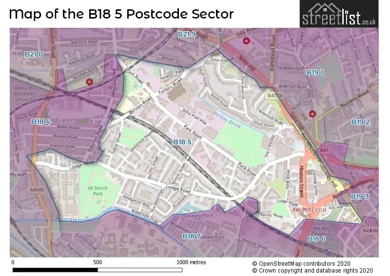
The B18 5 postcode sector is within the county of West Midlands.
Did you know? According to the 2021 Census, the B18 5 postcode sector is home to a bustling 5,483 residents!
Given that each sector allows for 400 unique postcode combinations. Letters C, I, K, M, O and V are not allowed in the last two letters of a postcode. With 118 postcodes already in use, this leaves 282 units available.
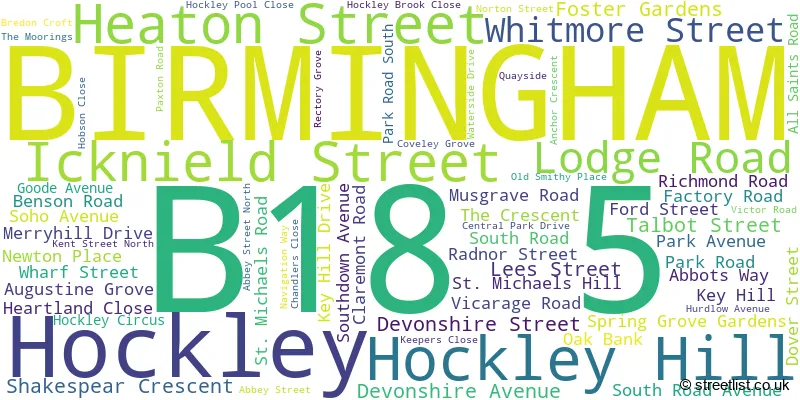
The largest settlements in the B18 5 postal code are Hockley and BIRMINGHAM.
The B18 5 Postcode shares a border with B19 3 (BIRMINGHAM, Hockley), B18 4 (BIRMINGHAM, Hockley, Winson Green), B18 6 (BIRMINGHAM, Hockley), B18 7 (BIRMINGHAM, Hockley), B19 1 (BIRMINGHAM, Lozells, Handsworth) and B21 0 (BIRMINGHAM, Handsworth).
The sector is within the post town of BIRMINGHAM.
B18 5 is a postcode sector within the B18 postcode district which is within the B Birmingham postcode area.
The Royal Mail delivery office for the B18 5 postal sector is the Hockley Delivery Office (b).
The area of the B18 5 postcode sector is 0.46 square miles which is 1.19 square kilometres or 293.26 square acres.
Waterways within the B18 5 postcode sector include the Birmingham Canal Navigations - Soho Loop.

Map of the B18 5 Postcode Sector
Explore the B18 5 postcode sector by using our free interactive map.
| B | 1 | 8 | - | 5 | X | X |
| B | 1 | 8 | Space | 5 | Letter | Letter |
Official List of Streets
BIRMINGHAM (44 Streets)
Hockley (23 Streets)
Unofficial Streets or Alternative Spellings
Hockley
GREAT HAMPTON STREET VYSE STREETBIRMINGHAM
ASHWIN ROAD BACCHUS ROAD GREAT KING STREET HANDSWORTH NEW ROAD HARMER STREET NINEVEH ROAD PIERS ROAD SCHOLARS CLOSE SOHO HILL WINSON GREEN ROAD ALL SAINTS STREET BERRY STREET BOULTON INDUSTRIAL ESTATE BOULTON MIDDLEWAY CEMETERY LANE CRESCENT AVENUE HOCKLEY FLYOVER KEY HILL CIRCUS NORTH WESTERN TERRACE QUEENS AVENUE SOHOPOOLWAY WHARF LANEHandsworth
HAMSTEAD ROADWeather Forecast for B18 5
Press Button to Show Forecast for Gib Heath
| Time Period | Icon | Description | Temperature | Rain Probability | Wind |
|---|---|---|---|---|---|
| 03:00 to 06:00 | Cloudy | 5.0°C (feels like 2.0°C) | 11.00% | ENE 9 mph | |
| 06:00 to 09:00 | Cloudy | 5.0°C (feels like 2.0°C) | 9.00% | ENE 7 mph | |
| 09:00 to 12:00 | Light rain | 7.0°C (feels like 4.0°C) | 51.00% | ENE 9 mph | |
| 12:00 to 15:00 | Light rain | 7.0°C (feels like 4.0°C) | 56.00% | ENE 9 mph | |
| 15:00 to 18:00 | Overcast | 8.0°C (feels like 5.0°C) | 16.00% | ENE 11 mph | |
| 18:00 to 21:00 | Overcast | 7.0°C (feels like 4.0°C) | 15.00% | NE 11 mph | |
| 21:00 to 00:00 | Overcast | 6.0°C (feels like 3.0°C) | 12.00% | NE 11 mph |
Press Button to Show Forecast for Gib Heath
| Time Period | Icon | Description | Temperature | Rain Probability | Wind |
|---|---|---|---|---|---|
| 00:00 to 03:00 | Overcast | 6.0°C (feels like 2.0°C) | 15.00% | NNE 9 mph | |
| 03:00 to 06:00 | Overcast | 5.0°C (feels like 2.0°C) | 19.00% | NNE 11 mph | |
| 06:00 to 09:00 | Light rain | 5.0°C (feels like 2.0°C) | 53.00% | N 11 mph | |
| 09:00 to 12:00 | Heavy rain | 6.0°C (feels like 3.0°C) | 73.00% | NNW 9 mph | |
| 12:00 to 15:00 | Light rain | 8.0°C (feels like 5.0°C) | 50.00% | NW 9 mph | |
| 15:00 to 18:00 | Overcast | 10.0°C (feels like 7.0°C) | 18.00% | WNW 9 mph | |
| 18:00 to 21:00 | Cloudy | 9.0°C (feels like 7.0°C) | 10.00% | WSW 7 mph | |
| 21:00 to 00:00 | Clear night | 7.0°C (feels like 5.0°C) | 3.00% | SW 7 mph |
Press Button to Show Forecast for Gib Heath
| Time Period | Icon | Description | Temperature | Rain Probability | Wind |
|---|---|---|---|---|---|
| 00:00 to 03:00 | Clear night | 5.0°C (feels like 3.0°C) | 1.00% | SW 4 mph | |
| 03:00 to 06:00 | Clear night | 4.0°C (feels like 1.0°C) | 2.00% | SSW 7 mph | |
| 06:00 to 09:00 | Sunny day | 5.0°C (feels like 2.0°C) | 2.00% | S 7 mph | |
| 09:00 to 12:00 | Partly cloudy (day) | 10.0°C (feels like 7.0°C) | 2.00% | S 11 mph | |
| 12:00 to 15:00 | Overcast | 12.0°C (feels like 9.0°C) | 10.00% | S 13 mph | |
| 15:00 to 18:00 | Cloudy | 13.0°C (feels like 10.0°C) | 7.00% | S 13 mph | |
| 18:00 to 21:00 | Partly cloudy (day) | 12.0°C (feels like 9.0°C) | 4.00% | S 11 mph | |
| 21:00 to 00:00 | Clear night | 9.0°C (feels like 7.0°C) | 3.00% | SSE 9 mph |
Press Button to Show Forecast for Gib Heath
| Time Period | Icon | Description | Temperature | Rain Probability | Wind |
|---|---|---|---|---|---|
| 00:00 to 03:00 | Clear night | 8.0°C (feels like 5.0°C) | 3.00% | SSE 9 mph | |
| 03:00 to 06:00 | Clear night | 7.0°C (feels like 4.0°C) | 3.00% | SE 9 mph | |
| 06:00 to 09:00 | Sunny day | 7.0°C (feels like 5.0°C) | 4.00% | SE 9 mph | |
| 09:00 to 12:00 | Sunny day | 12.0°C (feels like 10.0°C) | 6.00% | SE 11 mph | |
| 12:00 to 15:00 | Partly cloudy (day) | 14.0°C (feels like 12.0°C) | 11.00% | SE 13 mph | |
| 15:00 to 18:00 | Cloudy | 15.0°C (feels like 13.0°C) | 14.00% | SE 11 mph | |
| 18:00 to 21:00 | Light rain shower (day) | 14.0°C (feels like 12.0°C) | 30.00% | SE 9 mph | |
| 21:00 to 00:00 | Cloudy | 11.0°C (feels like 10.0°C) | 12.00% | ESE 7 mph |
Schools and Places of Education Within the B18 5 Postcode Sector
Benson Community School
Community school
Benson Road, Birmingham, West Midlands, B18 5TD
Head: Ms Rachel Medley
Ofsted Rating: Special Measures
Inspection: 2023-09-14 (226 days ago)
Website: Visit Benson Community School Website
Phone: 01215544913
Number of Pupils: 417
Flexible Learning School
Other independent school
23 All Saints Road, Birmingham, , B18 5QB
Head: Miss Shamim Akhtar
Ofsted Rating: Good
Inspection: 2022-05-12 (716 days ago)
Website: Visit Flexible Learning School Website
Phone: 01215547918
Number of Pupils: 82
Values Academy
Other independent special school
15 Key Hill, Birmingham, West Midlands, B18 5PB
Head: Ms Monika Sethi
Ofsted Rating: Good
Inspection: 2019-05-23 (1801 days ago)
Website: Visit Values Academy Website
Phone: 01215230222
Number of Pupils: 16
House Prices in the B18 5 Postcode Sector
| Type of Property | 2018 Average | 2018 Sales | 2017 Average | 2017 Sales | 2016 Average | 2016 Sales | 2015 Average | 2015 Sales |
|---|---|---|---|---|---|---|---|---|
| Detached | £0 | 0 | £291,667 | 3 | £221,500 | 3 | £180,000 | 1 |
| Semi-Detached | £143,000 | 6 | £242,000 | 3 | £134,250 | 8 | £134,333 | 6 |
| Terraced | £149,816 | 22 | £134,829 | 31 | £124,657 | 22 | £120,350 | 20 |
| Flats | £93,100 | 10 | £104,467 | 6 | £114,696 | 19 | £61,388 | 10 |
Important Postcodes B18 5 in the Postcode Sector
B18 5AP is the postcode for Royal Mail, Hockley Delivery Office, 23 Hockley Hill
B18 5BJ is the postcode for All Saints House, Lodge Road
B18 5LB is the postcode for VISITORS CENTRE, Soho House, 5 Soho Avenue, and Soho House, 5 Soho Avenue
B18 5QB is the postcode for Department of Social Services, 23 All Saints Road, and HOCKLEY DAY CENTRE, 27, All Saints Road, Hockley
B18 5SD is the postcode for ASHCROFT HOUSE, THE MOORINGS, Northern Birmingham Mental Health Trust, Ashcroft, Lodge Road, Ashcroft, Lodge Road, Mary Seacole House, Lodge Road, Northern Birmingham Mental Health Trust, Mary Seacole House, Lodge Road, ASHCROFT HOUSE, THE MOORINGS, BIRMINGHAM, and MARY SEACOLE HOUSE, LODGE ROAD, SOHO HOCKLEY
B18 5SJ is the postcode for 242, Lodge Road, Hockley
B18 5TD is the postcode for Benson Community School, Benson Road, and Benson Community School, Benson Road, Hockley
| The B18 5 Sector is within these Local Authorities |
|
|---|---|
| The B18 5 Sector is within these Counties |
|
| The B18 5 Sector is within these Water Company Areas |
|
Tourist Attractions within the B18 5 Postcode Area
We found 1 visitor attractions within the B18 postcode area
| Soho House Museum |
|---|
| Historic Properties |
| Historic House / House and Garden / Palace |
| View Soho House Museum on Google Maps |