The B70 7 postcode sector is within the county of West Midlands.
Did you know? According to the 2021 Census, the B70 7 postcode sector is home to a bustling 4,271 residents!
Given that each sector allows for 400 unique postcode combinations. Letters C, I, K, M, O and V are not allowed in the last two letters of a postcode. With 132 postcodes already in use, this leaves 268 units available.
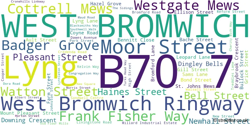
The largest settlements in the B70 7 postal code are WEST BROMWICH and Lyng.
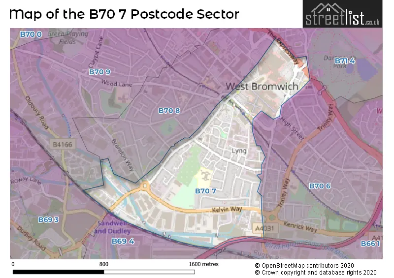
The B70 7 Postcode shares a border with B70 8 (WEST BROMWICH), B66 1 (SMETHWICK), B69 3 (Tividale, OLDBURY), B69 4 (OLDBURY), B70 6 (WEST BROMWICH), B70 9 (WEST BROMWICH) and B71 4 (WEST BROMWICH, Sandwell).
The sector is within the post town of WEST BROMWICH.
B70 7 is a postcode sector within the B7 postcode district which is within the B Birmingham postcode area.
The Royal Mail delivery office for the B70 7 postal sector is the unknown.
The area of the B70 7 postcode sector is 0.56 square miles which is 1.44 square kilometres or 355.84 square acres.
The B70 7 postcode sector is crossed by the M5 motorway.
Waterways within the B70 7 postcode sector include the New Main Line (Birmingham Canal, Birmingham Canal, Old Main Line (Birmingham Canal Navigations).

Map of the B70 7 Postcode Sector
Explore the B70 7 postcode sector by using our free interactive map.
| B | 7 | 0 | - | 7 | X | X |
| B | 7 | 0 | Space | 7 | Letter | Letter |
Official List of Streets
WEST BROMWICH (59 Streets)
Unofficial Streets or Alternative Spellings
SMETHWICK,
SPON LANE SOUTHWEST BROMWICH
BARTON STREET BOWATER STREET BRANDON WAY CAMBRIDGE STREET CAROLINE STREET CLIFFORD ROAD DEVONSHIRE DRIVE HERBERT STREET HOUGHTON STREET MARGARET STREET OVEREND STREET PARLIAMENT STREET PRICE STREET SPON LANE BIRMINGHAM AND BLACK COUNTRY CANAL CYCLEWAY BROMFORD BRIDGE BULL STREET CORNWALLIS ROAD DISABLED PARKING DUCHESS PARADE / HIGH STREET GIFFORDS WAY HALL STREET IZONS LANE LATTICE ACCOMODATION BRIDGE MCKEN COURT PRINCESS PARADE / HIGH STREET SCOTLAND PASSAGE SERVICE AREA H ST MICHAEL STREET ST MICHAEL STREET WEST BROMWICH RINGWAY STATION ROAD THE EXPRESSWAY TURKS HEADWAY WEST BROMWICH PARKWAYOLDBURY,
BROMFORD ROADWeather Forecast for B70 7
Press Button to Show Forecast for West Bromwich
| Time Period | Icon | Description | Temperature | Rain Probability | Wind |
|---|---|---|---|---|---|
| 06:00 to 09:00 | Cloudy | 11.0°C (feels like 10.0°C) | 5.00% | SE 4 mph | |
| 09:00 to 12:00 | Cloudy | 13.0°C (feels like 12.0°C) | 4.00% | ESE 4 mph | |
| 12:00 to 15:00 | Cloudy | 15.0°C (feels like 14.0°C) | 23.00% | E 7 mph | |
| 15:00 to 18:00 | Cloudy | 16.0°C (feels like 14.0°C) | 57.00% | NE 7 mph | |
| 18:00 to 21:00 | Light rain | 15.0°C (feels like 13.0°C) | 52.00% | NNE 9 mph | |
| 21:00 to 00:00 | Cloudy | 13.0°C (feels like 12.0°C) | 8.00% | NNE 9 mph |
Press Button to Show Forecast for West Bromwich
| Time Period | Icon | Description | Temperature | Rain Probability | Wind |
|---|---|---|---|---|---|
| 00:00 to 03:00 | Overcast | 11.0°C (feels like 9.0°C) | 11.00% | NNE 11 mph | |
| 03:00 to 06:00 | Overcast | 10.0°C (feels like 8.0°C) | 18.00% | NE 9 mph | |
| 06:00 to 09:00 | Overcast | 10.0°C (feels like 7.0°C) | 18.00% | NNE 11 mph | |
| 09:00 to 12:00 | Cloudy | 12.0°C (feels like 10.0°C) | 5.00% | NE 11 mph | |
| 12:00 to 15:00 | Overcast | 16.0°C (feels like 14.0°C) | 8.00% | NE 11 mph | |
| 15:00 to 18:00 | Cloudy | 18.0°C (feels like 16.0°C) | 7.00% | NE 11 mph | |
| 18:00 to 21:00 | Cloudy | 16.0°C (feels like 15.0°C) | 9.00% | NE 9 mph | |
| 21:00 to 00:00 | Cloudy | 13.0°C (feels like 12.0°C) | 7.00% | NNE 9 mph |
Press Button to Show Forecast for West Bromwich
| Time Period | Icon | Description | Temperature | Rain Probability | Wind |
|---|---|---|---|---|---|
| 00:00 to 03:00 | Overcast | 11.0°C (feels like 9.0°C) | 11.00% | NNE 7 mph | |
| 03:00 to 06:00 | Overcast | 10.0°C (feels like 9.0°C) | 13.00% | N 4 mph | |
| 06:00 to 09:00 | Overcast | 10.0°C (feels like 9.0°C) | 14.00% | NNW 7 mph | |
| 09:00 to 12:00 | Overcast | 11.0°C (feels like 10.0°C) | 15.00% | NW 7 mph | |
| 12:00 to 15:00 | Overcast | 14.0°C (feels like 12.0°C) | 15.00% | NW 9 mph | |
| 15:00 to 18:00 | Cloudy | 15.0°C (feels like 13.0°C) | 13.00% | WNW 9 mph | |
| 18:00 to 21:00 | Cloudy | 14.0°C (feels like 12.0°C) | 15.00% | WNW 9 mph | |
| 21:00 to 00:00 | Cloudy | 12.0°C (feels like 10.0°C) | 11.00% | W 9 mph |
Press Button to Show Forecast for West Bromwich
| Time Period | Icon | Description | Temperature | Rain Probability | Wind |
|---|---|---|---|---|---|
| 00:00 to 03:00 | Cloudy | 10.0°C (feels like 8.0°C) | 9.00% | W 7 mph | |
| 03:00 to 06:00 | Partly cloudy (night) | 9.0°C (feels like 7.0°C) | 7.00% | W 7 mph | |
| 06:00 to 09:00 | Cloudy | 9.0°C (feels like 7.0°C) | 9.00% | WSW 7 mph | |
| 09:00 to 12:00 | Cloudy | 11.0°C (feels like 10.0°C) | 8.00% | WSW 7 mph | |
| 12:00 to 15:00 | Cloudy | 14.0°C (feels like 13.0°C) | 10.00% | WSW 9 mph | |
| 15:00 to 18:00 | Cloudy | 16.0°C (feels like 14.0°C) | 9.00% | SSW 9 mph | |
| 18:00 to 21:00 | Cloudy | 15.0°C (feels like 13.0°C) | 10.00% | SW 9 mph | |
| 21:00 to 00:00 | Cloudy | 13.0°C (feels like 11.0°C) | 13.00% | SSW 9 mph |
Schools and Places of Education Within the B70 7 Postcode Sector
Lyng Primary School
Community school
Horton Street, West Bromwich, West Midlands, B70 7SQ
Head: Mr Andrew Fowler
Ofsted Rating: Good
Inspection: 2020-02-12 (1540 days ago)
Website: Visit Lyng Primary School Website
Phone: 01215531480
Number of Pupils: 492
House Prices in the B70 7 Postcode Sector
| Type of Property | 2018 Average | 2018 Sales | 2017 Average | 2017 Sales | 2016 Average | 2016 Sales | 2015 Average | 2015 Sales |
|---|---|---|---|---|---|---|---|---|
| Detached | £0 | 0 | £191,075 | 4 | £171,464 | 11 | £0 | 0 |
| Semi-Detached | £140,300 | 5 | £161,966 | 21 | £155,976 | 17 | £130,947 | 9 |
| Terraced | £156,660 | 15 | £152,526 | 33 | £458,255 | 46 | £142,104 | 41 |
| Flats | £112,000 | 1 | £0 | 0 | £123,667 | 3 | £111,500 | 2 |
Important Postcodes B70 7 in the Postcode Sector
B70 7AQ is the postcode for West Bromwich Police Station, Moor Street
B70 7AW is the postcode for The Lyng Centre for Health & Social Care, Frank Fisher Way, and Lyng Centre for Health & Social Care, Frank Fisher Way
B70 7AZ is the postcode for Places for People Leisure Management Ltd, West Bromwich Leisure Centre, Moor Street, and West Bromwich Leisure Centre, Moor Street
B70 7NN is the postcode for 104-105 Kings Square, Sandwell Centre
B70 7PG is the postcode for Sandwell College, Central Sixth, New Street, The Public, New Street, and Central Sixth, New Street
B70 7PJ is the postcode for West Midlands Police, New Street
B70 7PQ is the postcode for National Probation Service, Unity House, 14-16 New Street, and National Probation Service, Unity House, 14-16 West Bromwich Ringway, New Street
B70 7RH is the postcode for Royal Mail, West Bromwich Delivery Office, Lyng Lane
B70 7SQ is the postcode for Lyng Primary School, Horton Street
| The B70 7 Sector is within these Local Authorities |
|
|---|---|
| The B70 7 Sector is within these Counties |
|
| The B70 7 Sector is within these Water Company Areas |
|