The B74 postcode district is a postal district located in the B Birmingham postcode area with a population of 32,473 residents according to the 2021 England and Wales Census.
The area of the B74 postcode district is 7.55 square miles which is 19.56 square kilometres or 4,832.94 acres.
Currently, the B74 district has about 762 postcode units spread across 3 geographic postcode sectors.
Given that each sector allows for 400 unique postcode combinations, the district has a capacity of 1,200 postcodes. With 762 postcodes already in use, this leaves 438 units available.
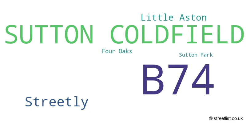
The largest settlement in the B74 postal code is SUTTON COLDFIELD followed by Streetly, and Little Aston.
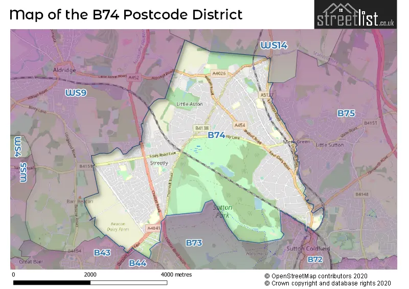
The B74 Postcode shares a border with B73 (SUTTON COLDFIELD, Wylde Green), B43 (BIRMINGHAM, Great Barr), WS9 (WALSALL, Aldridge, Walsall Wood), B72 (SUTTON COLDFIELD), B75 (SUTTON COLDFIELD, Canwell, Bassetts Pole) and WS14 (LICHFIELD, Shenstone, Whittington).
The primary settlement in the B74 postcode district is Sutton Coldfield, which is located in the county of West Midlands, England. Other significant settlements in the district include Four Oaks, Streetly, and Little Aston. The most significant postal town in the district is Sutton Coldfield.
For the district B74, we have data on 3 postcode sectors. Here's a breakdown: The sector B74 2, covers Sutton Coldfield in West Midlands. The sector B74 3, covers Sutton Coldfield and Streetly in West Midlands. The sector B74 3, covers Sutton Coldfield in Staffordshire. The sector B74 4, covers Sutton Coldfield in West Midlands.

Map of the B74 Postcode District
Explore the B74 postcode district by using our free interactive map.
When it comes to local government, postal geography often disregards political borders. However, for a breakdown in the B74 District: the district mostly encompasses the Birmingham District (B) (391 postcodes), followed by the Walsall District (B) area (290 postcodes), and finally, the Lichfield District area (78 postcodes).
Weather Forecast for B74
Press Button to Show Forecast for Four Oaks
| Time Period | Icon | Description | Temperature | Rain Probability | Wind |
|---|---|---|---|---|---|
| 09:00 to 12:00 | Cloudy | 5.0°C (feels like 3.0°C) | 4.00% | ENE 7 mph | |
| 12:00 to 15:00 | Cloudy | 7.0°C (feels like 5.0°C) | 9.00% | E 7 mph | |
| 15:00 to 18:00 | Cloudy | 8.0°C (feels like 6.0°C) | 9.00% | NE 7 mph | |
| 18:00 to 21:00 | Cloudy | 7.0°C (feels like 5.0°C) | 6.00% | ENE 9 mph | |
| 21:00 to 00:00 | Cloudy | 6.0°C (feels like 3.0°C) | 8.00% | ENE 9 mph |
Press Button to Show Forecast for Four Oaks
| Time Period | Icon | Description | Temperature | Rain Probability | Wind |
|---|---|---|---|---|---|
| 00:00 to 03:00 | Cloudy | 5.0°C (feels like 2.0°C) | 9.00% | ENE 9 mph | |
| 03:00 to 06:00 | Cloudy | 4.0°C (feels like 1.0°C) | 9.00% | NE 7 mph | |
| 06:00 to 09:00 | Cloudy | 4.0°C (feels like 1.0°C) | 9.00% | NE 9 mph | |
| 09:00 to 12:00 | Light rain | 6.0°C (feels like 3.0°C) | 53.00% | ENE 11 mph | |
| 12:00 to 15:00 | Overcast | 6.0°C (feels like 3.0°C) | 58.00% | ENE 11 mph | |
| 15:00 to 18:00 | Overcast | 7.0°C (feels like 4.0°C) | 46.00% | NE 11 mph | |
| 18:00 to 21:00 | Overcast | 7.0°C (feels like 4.0°C) | 18.00% | NE 11 mph | |
| 21:00 to 00:00 | Overcast | 6.0°C (feels like 3.0°C) | 12.00% | NE 11 mph |
Press Button to Show Forecast for Four Oaks
| Time Period | Icon | Description | Temperature | Rain Probability | Wind |
|---|---|---|---|---|---|
| 00:00 to 03:00 | Overcast | 5.0°C (feels like 2.0°C) | 13.00% | NNE 11 mph | |
| 03:00 to 06:00 | Overcast | 5.0°C (feels like 1.0°C) | 19.00% | NNE 11 mph | |
| 06:00 to 09:00 | Light rain | 5.0°C (feels like 1.0°C) | 50.00% | N 11 mph | |
| 09:00 to 12:00 | Heavy rain | 6.0°C (feels like 3.0°C) | 71.00% | NNW 11 mph | |
| 12:00 to 15:00 | Light rain | 8.0°C (feels like 5.0°C) | 48.00% | NW 9 mph | |
| 15:00 to 18:00 | Overcast | 9.0°C (feels like 7.0°C) | 17.00% | WNW 9 mph | |
| 18:00 to 21:00 | Cloudy | 9.0°C (feels like 7.0°C) | 10.00% | W 9 mph | |
| 21:00 to 00:00 | Clear night | 7.0°C (feels like 4.0°C) | 3.00% | SW 7 mph |
Press Button to Show Forecast for Four Oaks
| Time Period | Icon | Description | Temperature | Rain Probability | Wind |
|---|---|---|---|---|---|
| 00:00 to 03:00 | Clear night | 5.0°C (feels like 3.0°C) | 1.00% | SW 7 mph | |
| 03:00 to 06:00 | Clear night | 4.0°C (feels like 1.0°C) | 2.00% | SSW 9 mph | |
| 06:00 to 09:00 | Partly cloudy (day) | 5.0°C (feels like 1.0°C) | 1.00% | S 9 mph | |
| 09:00 to 12:00 | Partly cloudy (day) | 9.0°C (feels like 7.0°C) | 2.00% | S 11 mph | |
| 12:00 to 15:00 | Overcast | 12.0°C (feels like 9.0°C) | 10.00% | S 16 mph | |
| 15:00 to 18:00 | Cloudy | 13.0°C (feels like 10.0°C) | 8.00% | S 16 mph | |
| 18:00 to 21:00 | Cloudy | 12.0°C (feels like 9.0°C) | 7.00% | S 13 mph | |
| 21:00 to 00:00 | Clear night | 9.0°C (feels like 6.0°C) | 3.00% | SSE 11 mph |
Press Button to Show Forecast for Four Oaks
| Time Period | Icon | Description | Temperature | Rain Probability | Wind |
|---|---|---|---|---|---|
| 00:00 to 03:00 | Clear night | 7.0°C (feels like 4.0°C) | 4.00% | SSE 11 mph | |
| 03:00 to 06:00 | Clear night | 7.0°C (feels like 3.0°C) | 3.00% | SE 11 mph | |
| 06:00 to 09:00 | Sunny day | 7.0°C (feels like 4.0°C) | 4.00% | SE 11 mph | |
| 09:00 to 12:00 | Sunny day | 11.0°C (feels like 9.0°C) | 5.00% | SE 11 mph | |
| 12:00 to 15:00 | Partly cloudy (day) | 14.0°C (feels like 11.0°C) | 12.00% | SE 13 mph | |
| 15:00 to 18:00 | Cloudy | 15.0°C (feels like 12.0°C) | 12.00% | SE 13 mph | |
| 18:00 to 21:00 | Partly cloudy (day) | 14.0°C (feels like 12.0°C) | 10.00% | SE 11 mph | |
| 21:00 to 00:00 | Cloudy | 11.0°C (feels like 9.0°C) | 11.00% | ESE 9 mph |
Where is the B74 Postcode District?
The postcode district B74 is located in Sutton Coldfield, which is a district town. It is situated near several other towns, including Walsall (North West, 4.89 miles), Lichfield (North, 6.51 miles), West Bromwich (South West, 6.65 miles), Wednesbury (West, 6.74 miles), and Birmingham (South, 8.09 miles). Additionally, Sutton Coldfield is approximately 104.91 miles away from the centre of London.
The district is within the post town of SUTTON COLDFIELD.
The sector has postcodes within the nation of England.
The B74 Postcode District is covers the following regions.
- Birmingham - West Midlands - West Midlands (England)
- Walsall - West Midlands - West Midlands (England)
- Staffordshire CC - Shropshire and Staffordshire - West Midlands (England)
| Postcode Sector | Delivery Office |
|---|---|
| B74 2 | Sutton Coldfield Postal Delivery Office |
| B74 3 | Sutton Coldfield Postal Delivery Office |
| B74 4 | Sutton Coldfield Postal Delivery Office |
| B | 7 | 4 | - | X | X | X |
| B | 7 | 4 | Space | Numeric | Letter | Letter |
Current Monthly Rental Prices
| # Bedrooms | Min Price | Max Price | Avg Price |
|---|---|---|---|
| 2 | £775 | £1,350 | £1,082 |
| 3 | £1,050 | £1,850 | £1,564 |
| 4 | £2,000 | £2,950 | £2,383 |
| 5 | £1,995 | £8,500 | £4,998 |
| 6 | £4,250 | £7,000 | £5,625 |
Current House Prices
| # Bedrooms | Min Price | Max Price | Avg Price |
|---|---|---|---|
| 4 | £1,500,000 | £2,500,000 | £1,939,000 |
| 5 | £1,500,000 | £4,000,000 | £2,150,000 |
| 6 | £2,250,000 | £2,500,000 | £2,416,667 |
| 7 | £2,450,000 | £2,500,000 | £2,475,000 |
Estate Agents who Operate in the B74 District
| Logo | Name | Brand Name | Address | Contact Number | Total Properties |
|---|---|---|---|---|---|
 | Four Oaks | Acres | 74A Walsall Road, Four Oaks, Sutton Coldfield, B74 4QY | 0121 387 6448 | 66 |
 | Covering West Midlands | Homewise | B46 1DL | 01273 092409 | 46 |
 | Streetly | Paul Carr | 133 Chester Road, Streetly, Sutton Coldfield, B74 2HE | 0121 387 6500 | 45 |
 | Four Oaks | Paul Carr | 15-17 Belwell Lane, Sutton Coldfield, B74 4AA | 0121 387 6418 | 41 |
 | Four Oaks | Green & Company | 1 Carlton House 18 Mere Green Road, Four Oaks Sutton Coldfield, B75 5BS | 0121 387 6668 | 23 |
| Type of Property | 2018 Average | 2018 Sales | 2017 Average | 2017 Sales | 2016 Average | 2016 Sales | 2015 Average | 2015 Sales |
|---|---|---|---|---|---|---|---|---|
| Detached | £612,381 | 206 | £623,722 | 243 | £536,832 | 226 | £547,769 | 275 |
| Semi-Detached | £309,326 | 185 | £291,702 | 169 | £273,961 | 175 | £238,361 | 156 |
| Terraced | £281,122 | 34 | £246,816 | 47 | £250,179 | 30 | £216,767 | 44 |
| Flats | £189,057 | 145 | £178,932 | 135 | £170,279 | 158 | £169,532 | 160 |