The B77 4 postcode sector stands on the Staffordshire and Warwickshire border.
Did you know? According to the 2021 Census, the B77 4 postcode sector is home to a bustling 14,069 residents!
Given that each sector allows for 400 unique postcode combinations. Letters C, I, K, M, O and V are not allowed in the last two letters of a postcode. With 196 postcodes already in use, this leaves 204 units available.
The largest settlement in the B77 4 postal code is Wilnecote followed by TAMWORTH, and Amington.
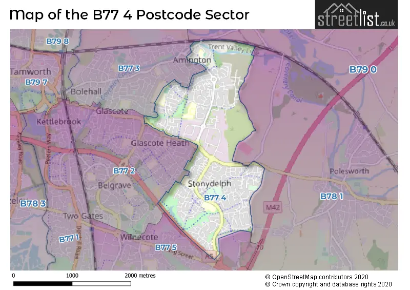
The B77 4 Postcode shares a border with B77 2 (TAMWORTH, Glascote, Wilnecote), B77 3 (TAMWORTH, Amington, Bolehall), B77 5 (Wilnecote, Hockley, TAMWORTH), B78 1 (Polesworth, Dordon, Birchmoor) and B79 0 (TAMWORTH, Warton, Clifton Campville).
The sector is within the post town of TAMWORTH.
B77 4 is a postcode sector within the B77 postcode district which is within the B Birmingham postcode area.
The Royal Mail delivery office for the B77 4 postal sector is the Tamworth Delivery Office.
The area of the B77 4 postcode sector is 1.63 square miles which is 4.22 square kilometres or 1,043.70 square acres.
The B77 4 postcode sector is crossed by the A5 Major A road.
Waterways within the B77 4 postcode sector include the Coventry Canal.

Map of the B77 4 Postcode Sector
Explore the B77 4 postcode sector by using our free interactive map.
| B | 7 | 7 | - | 4 | X | X |
| B | 7 | 7 | Space | 4 | Letter | Letter |
Official List of Streets
Wilnecote (82 Streets)
Amington (31 Streets)
TAMWORTH (44 Streets)
Unofficial Streets or Alternative Spellings
Wilnecote
STONYDELPH LANEPolesworth
TAMWORTH ROADBirchmoor
GREEN LANETAMWORTH
DELTIC MARLBOROUGH WAY SHEEPCOTE LANE TILIA ROAD ABASTON DRIVE ANNANDALE BY PASS ROAD DOG LANE FELSPAR ROAD GREENLEA JASMINE ROAD LINDERA MERCIAN WAY PENNINE WAY REPINGTON ROAD NORTH REPINGTON ROAD SOUTH ROBEYS LANE SAFRON SILICA ROAD STONYDELPH LANE TAMWORTH ROAD (AMINGTON)Alvecote
SHUTTINGTON ROADGlascote
GLASCOTE ROADWeather Forecast for B77 4
Press Button to Show Forecast for Snowdome Tamworth
| Time Period | Icon | Description | Temperature | Rain Probability | Wind |
|---|---|---|---|---|---|
| 21:00 to 00:00 | Cloudy | 7.0°C (feels like 4.0°C) | 7.00% | ENE 9 mph |
Press Button to Show Forecast for Snowdome Tamworth
| Time Period | Icon | Description | Temperature | Rain Probability | Wind |
|---|---|---|---|---|---|
| 00:00 to 03:00 | Cloudy | 6.0°C (feels like 3.0°C) | 8.00% | ENE 7 mph | |
| 03:00 to 06:00 | Cloudy | 5.0°C (feels like 3.0°C) | 7.00% | NE 7 mph | |
| 06:00 to 09:00 | Cloudy | 5.0°C (feels like 2.0°C) | 8.00% | NE 7 mph | |
| 09:00 to 12:00 | Cloudy | 8.0°C (feels like 5.0°C) | 52.00% | ENE 11 mph | |
| 12:00 to 15:00 | Light rain | 8.0°C (feels like 5.0°C) | 51.00% | ENE 9 mph | |
| 15:00 to 18:00 | Overcast | 8.0°C (feels like 5.0°C) | 41.00% | NE 11 mph | |
| 18:00 to 21:00 | Overcast | 8.0°C (feels like 5.0°C) | 13.00% | NE 11 mph | |
| 21:00 to 00:00 | Overcast | 7.0°C (feels like 4.0°C) | 12.00% | NE 9 mph |
Press Button to Show Forecast for Snowdome Tamworth
| Time Period | Icon | Description | Temperature | Rain Probability | Wind |
|---|---|---|---|---|---|
| 00:00 to 03:00 | Overcast | 6.0°C (feels like 3.0°C) | 12.00% | NNE 9 mph | |
| 03:00 to 06:00 | Overcast | 6.0°C (feels like 3.0°C) | 26.00% | NNE 11 mph | |
| 06:00 to 09:00 | Light rain | 6.0°C (feels like 3.0°C) | 53.00% | N 11 mph | |
| 09:00 to 12:00 | Heavy rain | 7.0°C (feels like 4.0°C) | 71.00% | NNW 9 mph | |
| 12:00 to 15:00 | Light rain | 9.0°C (feels like 6.0°C) | 48.00% | NW 9 mph | |
| 15:00 to 18:00 | Cloudy | 10.0°C (feels like 8.0°C) | 15.00% | WNW 9 mph | |
| 18:00 to 21:00 | Partly cloudy (day) | 10.0°C (feels like 8.0°C) | 8.00% | W 7 mph | |
| 21:00 to 00:00 | Clear night | 7.0°C (feels like 6.0°C) | 3.00% | SW 7 mph |
Press Button to Show Forecast for Snowdome Tamworth
| Time Period | Icon | Description | Temperature | Rain Probability | Wind |
|---|---|---|---|---|---|
| 00:00 to 03:00 | Clear night | 6.0°C (feels like 4.0°C) | 1.00% | SW 7 mph | |
| 03:00 to 06:00 | Clear night | 5.0°C (feels like 2.0°C) | 2.00% | SSW 7 mph | |
| 06:00 to 09:00 | Partly cloudy (day) | 6.0°C (feels like 3.0°C) | 2.00% | S 7 mph | |
| 09:00 to 12:00 | Partly cloudy (day) | 10.0°C (feels like 8.0°C) | 2.00% | S 11 mph | |
| 12:00 to 15:00 | Overcast | 13.0°C (feels like 10.0°C) | 10.00% | S 13 mph | |
| 15:00 to 18:00 | Cloudy | 14.0°C (feels like 11.0°C) | 8.00% | S 13 mph | |
| 18:00 to 21:00 | Cloudy | 13.0°C (feels like 10.0°C) | 7.00% | S 11 mph | |
| 21:00 to 00:00 | Clear night | 10.0°C (feels like 8.0°C) | 3.00% | SSE 9 mph |
Press Button to Show Forecast for Snowdome Tamworth
| Time Period | Icon | Description | Temperature | Rain Probability | Wind |
|---|---|---|---|---|---|
| 00:00 to 03:00 | Clear night | 8.0°C (feels like 6.0°C) | 4.00% | SSE 9 mph | |
| 03:00 to 06:00 | Clear night | 8.0°C (feels like 5.0°C) | 3.00% | SE 9 mph | |
| 06:00 to 09:00 | Sunny day | 8.0°C (feels like 6.0°C) | 4.00% | SE 9 mph | |
| 09:00 to 12:00 | Sunny day | 12.0°C (feels like 10.0°C) | 5.00% | SE 11 mph | |
| 12:00 to 15:00 | Partly cloudy (day) | 15.0°C (feels like 13.0°C) | 11.00% | SE 13 mph | |
| 15:00 to 18:00 | Cloudy | 16.0°C (feels like 14.0°C) | 12.00% | SE 11 mph | |
| 18:00 to 21:00 | Partly cloudy (day) | 15.0°C (feels like 13.0°C) | 10.00% | ESE 9 mph | |
| 21:00 to 00:00 | Cloudy | 12.0°C (feels like 11.0°C) | 11.00% | ESE 7 mph |
Schools and Places of Education Within the B77 4 Postcode Sector
Amington Heath Primary School and Nursery
Community school
Quince, Tamworth, Staffordshire, B77 4EN
Head: Mrs Charlotte Davies
Ofsted Rating: Good
Inspection: 2018-11-28 (1976 days ago)
Website: Visit Amington Heath Primary School and Nursery Website
Phone: 01827337465
Number of Pupils: 153
Landau Forte Academy Greenacres
Academy sponsor led
Levett Road, Tamworth, Staffordshire, B77 4AB
Head: Mrs Louise Bridge
Ofsted Rating: Good
Inspection: 2019-06-27 (1765 days ago)
Website: Visit Landau Forte Academy Greenacres Website
Phone: 01827300490
Number of Pupils: 367
Landau Forte Academy, Amington
Academy sponsor led
Woodland Road, Tamworth, Staffordshire, B77 4FF
Head: Mr Andrew Deen
Ofsted Rating: Good
Inspection: 2022-05-11 (716 days ago)
Website: Visit Landau Forte Academy, Amington Website
Phone: 01827301800
Number of Pupils: 954
Stoneydelph Primary School
Academy converter
Crowden Road, Tamworth, Staffordshire, B77 4LS
Head: Mrs Esther Parsons
Ofsted Rating: Good
Inspection: 2023-11-16 (162 days ago)
Website: Visit Stoneydelph Primary School Website
Phone: 01827896666
Number of Pupils: 294
Three Peaks Primary Academy
Academy sponsor led
Fossdale Road, Tamworth, Staffordshire, B77 4HN
Head: Mr Richard Penn-Bourton
Ofsted Rating: Good
Inspection: 2023-02-03 (448 days ago)
Website: Visit Three Peaks Primary Academy Website
Phone: 01827896424
Number of Pupils: 372
House Prices in the B77 4 Postcode Sector
| Type of Property | 2018 Average | 2018 Sales | 2017 Average | 2017 Sales | 2016 Average | 2016 Sales | 2015 Average | 2015 Sales |
|---|---|---|---|---|---|---|---|---|
| Detached | £319,509 | 86 | £314,088 | 76 | £260,795 | 69 | £219,847 | 56 |
| Semi-Detached | £193,623 | 72 | £157,689 | 62 | £160,580 | 66 | £139,904 | 58 |
| Terraced | £161,283 | 59 | £137,066 | 58 | £129,795 | 59 | £117,407 | 58 |
| Flats | £104,050 | 10 | £98,985 | 27 | £90,755 | 14 | £66,500 | 3 |
Important Postcodes B77 4 in the Postcode Sector
B77 4AB is the postcode for Landau Forte Academy Greenacres, Levett Road
B77 4DT is the postcode for Staffordshire County Council, Tamworth Adult Training Centre, Amington Industrial Estate, Silica Road
B77 4ED is the postcode for Sandy Way Depot, Amington Industrial Estate
B77 4EN is the postcode for Two Rivers School, Quince, TWO RIVERS PRIMARY SCHOOL, QUINCE, AMINGTON, Amington Heath Community School, Quince, and AMINGTON HEATH PRIMARY SCHOOL AND NURSERY, QUINCE, AMINGTON
B77 4FF is the postcode for Landau Forte Academy Amington, Woodland Road
B77 4HN is the postcode for Three Peaks Primary School (Infants Site), Fossdale Road, Wilnecote, PEN-Y-GHENT BLOCK, Three Peaks Primary School (Junior Site), Fossdale Road, Three Peaks Primary School (Junior Site), Fossdale Road, Wilnecote, KS2, Three Peaks Primary Academy, Fossdale Road, Three Peaks Primary School (Infants Site), Fossdale Road, Three Peaks Primary School (Junior Site), Fossdale Road, and KS1, Three Peaks Primary Academy, Fossdale Road
B77 4JA is the postcode for Stonydelph Health Centre, 55 Ellerbeck
B77 4LS is the postcode for Stoneydelph Primary School - Juniors, Crowden Road, Stonydelph Infants School, Stonydelph Primary School, Crowden Road, Stonydelph Junior School, Stonydelph Primary School, Crowden Road, Stoneydelph County Primary School, Crowden Road, Wilnecote, and Stoneydelph County Primary School, Crowden Road
| The B77 4 Sector is within these Local Authorities |
|
|---|---|
| The B77 4 Sector is within these Counties |
|
| The B77 4 Sector is within these Water Company Areas |
|