The B8 postcode district is a postal district located in the B Birmingham postcode area with a population of 46,609 residents according to the 2021 England and Wales Census.
The area of the B8 postcode district is 2.45 square miles which is 6.35 square kilometres or 1,569.98 acres.
Currently, the B8 district has about 578 postcode units spread across 4 geographic postcode sectors.
Given that each sector allows for 400 unique postcode combinations, the district has a capacity of 1,600 postcodes. With 578 postcodes already in use, this leaves 1022 units available.
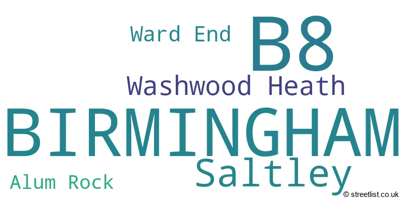
The largest settlement in the B8 postal code is BIRMINGHAM followed by Saltley, and Washwood Heath.
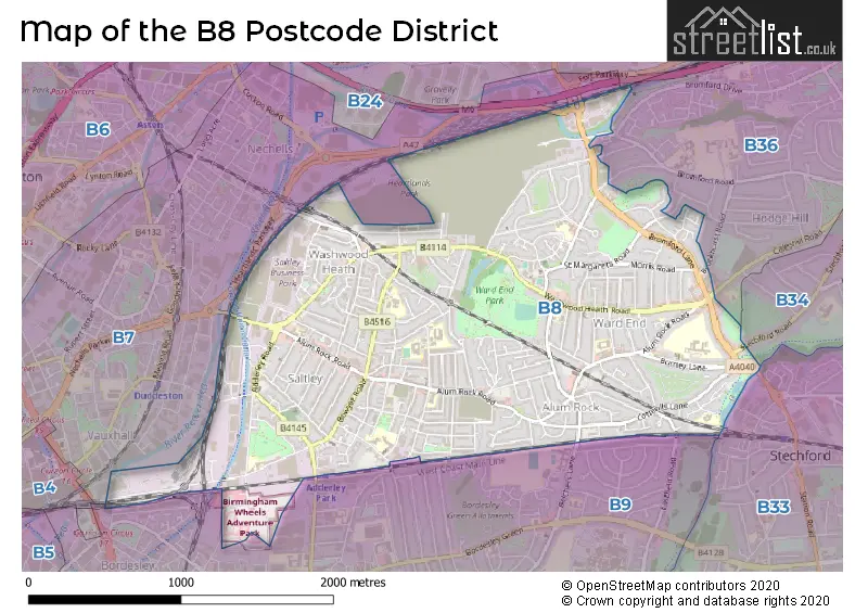
The B8 Postcode shares a border with B36 (BIRMINGHAM, Castle Bromwich, Kingshurst), B7 (BIRMINGHAM, Nechells) and B9 (BIRMINGHAM, Bordesley Green, Small Heath).
The primary settlement in the B8 postcode district is Birmingham, which is located in the county of West Midlands in England. Other significant settlements in this district include Saltley, Ward End, and Alum Rock. The most significant post town in this district is Birmingham.
For the district B8, we have data on 3 postcode sectors. Here's a breakdown: The sector B8 1, covers Birmingham and Saltley in West Midlands. The sector B8 2, covers Birmingham in West Midlands. The sector B8 3, covers Birmingham and Saltley in West Midlands.

Map of the B8 Postcode District
Explore the B8 postcode district by using our free interactive map.
When it comes to local government, postal geography often disregards political borders. However, for a breakdown in the B8 District: the district mostly encompasses the Birmingham District (B) area with a total of 578 postcodes.
Where is the B8 Postcode District?
The data indicates that the B8 postcode district is located in the town of Birmingham. It is worth noting that this district is surrounded by several nearby towns. To the south, there is Solihull, which is approximately 4.4 miles away. Sutton Coldfield is located to the north, at a distance of about 5.4 miles. Smethwick is situated to the west, around 5.6 miles away. Additionally, Wednesbury is positioned to the northwest, with a distance of approximately 8.8 miles. In terms of the distance from the district to London, it is roughly 99.9 miles.
The district is within the post town of BIRMINGHAM.
The sector has postcodes within the nation of England.
The B8 Postcode District is in the Birmingham region of West Midlands within the West Midlands (England).
Weather Forecast for B8
Press Button to Show Forecast for Alum Rock
| Time Period | Icon | Description | Temperature | Rain Probability | Wind |
|---|---|---|---|---|---|
| 21:00 to 00:00 | Cloudy | 14.0°C (feels like 12.0°C) | 4.00% | ESE 9 mph |
Press Button to Show Forecast for Alum Rock
| Time Period | Icon | Description | Temperature | Rain Probability | Wind |
|---|---|---|---|---|---|
| 00:00 to 03:00 | Cloudy | 13.0°C (feels like 11.0°C) | 5.00% | ESE 9 mph | |
| 03:00 to 06:00 | Cloudy | 12.0°C (feels like 11.0°C) | 5.00% | ESE 7 mph | |
| 06:00 to 09:00 | Cloudy | 13.0°C (feels like 12.0°C) | 9.00% | ESE 7 mph | |
| 09:00 to 12:00 | Cloudy | 15.0°C (feels like 14.0°C) | 49.00% | ESE 9 mph | |
| 12:00 to 15:00 | Light rain shower (day) | 17.0°C (feels like 15.0°C) | 42.00% | ESE 9 mph | |
| 15:00 to 18:00 | Light rain shower (day) | 17.0°C (feels like 16.0°C) | 34.00% | E 9 mph | |
| 18:00 to 21:00 | Cloudy | 16.0°C (feels like 15.0°C) | 10.00% | ESE 7 mph | |
| 21:00 to 00:00 | Partly cloudy (night) | 14.0°C (feels like 13.0°C) | 5.00% | ESE 4 mph |
Press Button to Show Forecast for Alum Rock
| Time Period | Icon | Description | Temperature | Rain Probability | Wind |
|---|---|---|---|---|---|
| 00:00 to 03:00 | Partly cloudy (night) | 12.0°C (feels like 11.0°C) | 3.00% | SE 4 mph | |
| 03:00 to 06:00 | Partly cloudy (night) | 10.0°C (feels like 10.0°C) | 5.00% | S 4 mph | |
| 06:00 to 09:00 | Cloudy | 11.0°C (feels like 11.0°C) | 8.00% | NE 2 mph | |
| 09:00 to 12:00 | Cloudy | 16.0°C (feels like 16.0°C) | 10.00% | ENE 2 mph | |
| 12:00 to 15:00 | Cloudy | 18.0°C (feels like 17.0°C) | 13.00% | SSE 4 mph | |
| 15:00 to 18:00 | Cloudy | 18.0°C (feels like 18.0°C) | 15.00% | SSE 4 mph | |
| 18:00 to 21:00 | Cloudy | 17.0°C (feels like 16.0°C) | 18.00% | NNE 4 mph | |
| 21:00 to 00:00 | Cloudy | 15.0°C (feels like 14.0°C) | 17.00% | W 4 mph |
Press Button to Show Forecast for Alum Rock
| Time Period | Icon | Description | Temperature | Rain Probability | Wind |
|---|---|---|---|---|---|
| 00:00 to 03:00 | Cloudy | 13.0°C (feels like 13.0°C) | 15.00% | WNW 4 mph | |
| 03:00 to 06:00 | Partly cloudy (night) | 12.0°C (feels like 11.0°C) | 11.00% | WNW 4 mph | |
| 06:00 to 09:00 | Partly cloudy (day) | 12.0°C (feels like 12.0°C) | 8.00% | WNW 4 mph | |
| 09:00 to 12:00 | Partly cloudy (day) | 15.0°C (feels like 14.0°C) | 10.00% | WNW 7 mph | |
| 12:00 to 15:00 | Light rain shower (day) | 18.0°C (feels like 17.0°C) | 36.00% | W 7 mph | |
| 15:00 to 18:00 | Light rain shower (day) | 19.0°C (feels like 18.0°C) | 39.00% | WNW 7 mph | |
| 18:00 to 21:00 | Light rain shower (day) | 18.0°C (feels like 17.0°C) | 36.00% | NW 7 mph | |
| 21:00 to 00:00 | Partly cloudy (night) | 14.0°C (feels like 14.0°C) | 11.00% | WNW 7 mph |
Press Button to Show Forecast for Alum Rock
| Time Period | Icon | Description | Temperature | Rain Probability | Wind |
|---|---|---|---|---|---|
| 00:00 to 03:00 | Partly cloudy (night) | 12.0°C (feels like 11.0°C) | 5.00% | NW 7 mph | |
| 03:00 to 06:00 | Cloudy | 11.0°C (feels like 10.0°C) | 6.00% | NW 7 mph | |
| 06:00 to 09:00 | Cloudy | 12.0°C (feels like 11.0°C) | 10.00% | N 7 mph | |
| 09:00 to 12:00 | Overcast | 15.0°C (feels like 14.0°C) | 12.00% | NNE 7 mph | |
| 12:00 to 15:00 | Cloudy | 18.0°C (feels like 17.0°C) | 12.00% | NNE 9 mph | |
| 15:00 to 18:00 | Light rain shower (day) | 19.0°C (feels like 17.0°C) | 32.00% | NNE 9 mph | |
| 18:00 to 21:00 | Light rain shower (day) | 17.0°C (feels like 16.0°C) | 34.00% | NNE 9 mph | |
| 21:00 to 00:00 | Clear night | 14.0°C (feels like 13.0°C) | 9.00% | NNE 7 mph |
| Postcode Sector | Delivery Office |
|---|---|
| B8 1 | Eastern (b) Delivery Office |
| B8 2 | Eastern (b) Delivery Office |
| B8 3 | Eastern (b) Delivery Office |
| B | 8 | - | X | X | X |
| B | 8 | Space | Numeric | Letter | Letter |
Current Monthly Rental Prices
| # Bedrooms | Min Price | Max Price | Avg Price |
|---|---|---|---|
| £645 | £645 | £645 | |
| 1 | £600 | £600 | £600 |
| 3 | £1,150 | £1,200 | £1,175 |
| 5 | £1,700 | £1,700 | £1,700 |
Current House Prices
| # Bedrooms | Min Price | Max Price | Avg Price |
|---|---|---|---|
| 2 | £175,000 | £190,000 | £181,250 |
| 3 | £160,000 | £260,000 | £220,413 |
| 4 | £230,000 | £425,000 | £307,222 |
| 5 | £499,950 | £499,950 | £499,950 |
Estate Agents who Operate in the B8 District
| Logo | Name | Brand Name | Address | Contact Number | Total Properties |
|---|---|---|---|---|---|
 | Castle Bromwich | Burchell Edwards | 2-4 Hurst Lane, Castle Bromwich Birmingham, B34 7HR | 0121 387 6362 | 6 |
 | covering Birmingham | Purplebricks | Suite 7 First Floor Cranmore Drive Shirley Solihull B90 4RZ | 024 7542 7306 | 5 |
 | Castle Bromwich | Dixons | 333 Chester Road, Castle Bromwich, Birmingham, W Midlands, B36 0JG | 0121 387 6272 | 4 |
 | Hampstead | Auction House London | 5 Hampstead Gate, 1A Frognal, Hampstead, London, NW3 6AL | 020 3897 6030 | 4 |
 | Stechford | YOUR MOVE Murray Rogers | 165 Station Road, Stechford, Birmingham, B33 8BA | 0121 387 6313 | 3 |
Yearly House Price Averages for the B8 Postcode District
| Type of Property | 2018 Average | 2018 Sales | 2017 Average | 2017 Sales | 2016 Average | 2016 Sales | 2015 Average | 2015 Sales |
|---|---|---|---|---|---|---|---|---|
| Detached | £213,444 | 9 | £217,612 | 13 | £196,658 | 6 | £161,667 | 3 |
| Semi-Detached | £144,503 | 66 | £129,938 | 65 | £120,359 | 64 | £123,745 | 47 |
| Terraced | £129,054 | 182 | £116,955 | 194 | £108,598 | 181 | £105,251 | 167 |
| Flats | £70,900 | 5 | £67,400 | 5 | £55,800 | 10 | £56,833 | 6 |