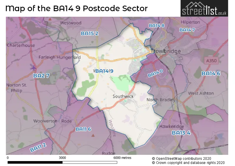
The BA14 9 postcode sector stands on the Somerset and Wiltshire border.
Did you know? According to the 2021 Census, the BA14 9 postcode sector is home to a bustling 9,050 residents!
Given that each sector allows for 400 unique postcode combinations. Letters C, I, K, M, O and V are not allowed in the last two letters of a postcode. With 240 postcodes already in use, this leaves 160 units available.
The largest settlement in the BA14 9 postal code is TROWBRIDGE followed by Southwick, and Wingfield.
The BA14 9 Postcode shares a border with BA11 6 (Beckington, Rode), BA14 8 (TROWBRIDGE, Staverton, Canal Road Industrial Estate), BA15 1 (BRADFORD-ON-AVON), BA15 2 (Winsley, BRADFORD-ON-AVON, Lower Westwood), BA2 7 (Norton St. Philip, Limpley Stoke, Freshford), BA13 4 (WESTBURY, Dilton Marsh, Bratton) and BA14 0 (TROWBRIDGE, North Bradley, White Horse Business Park).
The sector is within the post town of TROWBRIDGE.
BA14 9 is a postcode sector within the BA1 postcode district which is within the BA Bath postcode area.
The Royal Mail delivery office for the BA14 9 postal sector is the Bath Delivery Office.
The area of the BA14 9 postcode sector is 7.52 square miles which is 19.46 square kilometres or 4,809.84 square acres.
Waterways within the BA14 9 postcode sector include the River Frome.

Map of the BA14 9 Postcode Sector
Explore the BA14 9 postcode sector by using our free interactive map.
| B | A | 1 | 4 | - | 9 | X | X |
| B | A | 1 | 4 | Space | 9 | Letter | Letter |
Official List of Streets
TROWBRIDGE (93 Streets)
Southwick (31 Streets)
Wingfield (10 Streets)
North Bradley (4 Streets)
Unofficial Streets or Alternative Spellings
TROWBRIDGE
AVENUE ROAD GLOUCESTER ROAD NEWTOWN WEST STREET WESTBOURNE ROAD WHITEROW PARKBRADFORD-ON-AVON,
WESTWOOD ROADNorth Bradley
CHURCH LANE SOUTHWICK ROADRode
BRADFORD ROAD FROME ROADWeather Forecast for BA14 9
Press Button to Show Forecast for Westwood Manor
| Time Period | Icon | Description | Temperature | Rain Probability | Wind |
|---|---|---|---|---|---|
| 06:00 to 09:00 | Cloudy | 10.0°C (feels like 10.0°C) | 5.00% | NE 2 mph | |
| 09:00 to 12:00 | Partly cloudy (day) | 12.0°C (feels like 12.0°C) | 1.00% | E 2 mph | |
| 12:00 to 15:00 | Cloudy | 15.0°C (feels like 15.0°C) | 12.00% | E 2 mph | |
| 15:00 to 18:00 | Light rain | 15.0°C (feels like 14.0°C) | 60.00% | N 7 mph | |
| 18:00 to 21:00 | Heavy rain | 12.0°C (feels like 11.0°C) | 89.00% | NW 7 mph | |
| 21:00 to 00:00 | Heavy rain | 11.0°C (feels like 10.0°C) | 88.00% | WNW 7 mph |
Press Button to Show Forecast for Westwood Manor
| Time Period | Icon | Description | Temperature | Rain Probability | Wind |
|---|---|---|---|---|---|
| 00:00 to 03:00 | Cloudy | 11.0°C (feels like 10.0°C) | 53.00% | NW 9 mph | |
| 03:00 to 06:00 | Heavy rain | 11.0°C (feels like 10.0°C) | 86.00% | NNW 7 mph | |
| 06:00 to 09:00 | Heavy rain | 11.0°C (feels like 10.0°C) | 73.00% | NNE 7 mph | |
| 09:00 to 12:00 | Light rain shower (day) | 12.0°C (feels like 11.0°C) | 37.00% | NW 4 mph | |
| 12:00 to 15:00 | Light rain | 14.0°C (feels like 12.0°C) | 50.00% | NW 9 mph | |
| 15:00 to 18:00 | Cloudy | 14.0°C (feels like 12.0°C) | 14.00% | WNW 11 mph | |
| 18:00 to 21:00 | Light rain | 12.0°C (feels like 10.0°C) | 42.00% | WNW 13 mph | |
| 21:00 to 00:00 | Light rain | 11.0°C (feels like 8.0°C) | 44.00% | W 13 mph |
Press Button to Show Forecast for Westwood Manor
| Time Period | Icon | Description | Temperature | Rain Probability | Wind |
|---|---|---|---|---|---|
| 00:00 to 03:00 | Cloudy | 10.0°C (feels like 8.0°C) | 16.00% | W 11 mph | |
| 03:00 to 06:00 | Light rain | 10.0°C (feels like 8.0°C) | 46.00% | W 11 mph | |
| 06:00 to 09:00 | Light rain | 10.0°C (feels like 8.0°C) | 46.00% | W 11 mph | |
| 09:00 to 12:00 | Light rain | 11.0°C (feels like 9.0°C) | 44.00% | W 13 mph | |
| 12:00 to 15:00 | Cloudy | 13.0°C (feels like 11.0°C) | 10.00% | W 13 mph | |
| 15:00 to 18:00 | Cloudy | 14.0°C (feels like 12.0°C) | 8.00% | W 11 mph | |
| 18:00 to 21:00 | Partly cloudy (day) | 13.0°C (feels like 11.0°C) | 6.00% | W 9 mph | |
| 21:00 to 00:00 | Clear night | 9.0°C (feels like 8.0°C) | 3.00% | W 7 mph |
Press Button to Show Forecast for Westwood Manor
| Time Period | Icon | Description | Temperature | Rain Probability | Wind |
|---|---|---|---|---|---|
| 00:00 to 03:00 | Clear night | 8.0°C (feels like 6.0°C) | 3.00% | WSW 7 mph | |
| 03:00 to 06:00 | Clear night | 7.0°C (feels like 5.0°C) | 4.00% | SW 4 mph | |
| 06:00 to 09:00 | Mist | 8.0°C (feels like 7.0°C) | 15.00% | SSW 4 mph | |
| 09:00 to 12:00 | Cloudy | 13.0°C (feels like 11.0°C) | 8.00% | SW 9 mph | |
| 12:00 to 15:00 | Light rain | 14.0°C (feels like 13.0°C) | 39.00% | SW 11 mph | |
| 15:00 to 18:00 | Light rain | 15.0°C (feels like 13.0°C) | 50.00% | SSW 11 mph | |
| 18:00 to 21:00 | Cloudy | 14.0°C (feels like 12.0°C) | 17.00% | SSW 9 mph | |
| 21:00 to 00:00 | Overcast | 11.0°C (feels like 10.0°C) | 11.00% | SSW 7 mph |
Schools and Places of Education Within the BA14 9 Postcode Sector
Southwick Church of England Primary School
Voluntary controlled school
Hollis Way, Trowbridge, Wiltshire, BA14 9PH
Head: Mr David Cook
Ofsted Rating: Good
Inspection: 2022-03-17 (776 days ago)
Website: Visit Southwick Church of England Primary School Website
Phone: 01225763325
Number of Pupils: 183
St Augustine's Catholic College
Academy converter
Wingfield Road, Trowbridge, Wiltshire, BA14 9EN
Head: Mr Aidan Dowle
Ofsted Rating: Requires improvement
Inspection: 2021-11-11 (902 days ago)
Website: Visit St Augustine's Catholic College Website
Phone: 01225350001
Number of Pupils: 946
St John's Catholic Primary School, Trowbridge
Voluntary aided school
Wingfield Road, Trowbridge, Wiltshire, BA14 9EA
Head: Mrs Tracey Sessions
Ofsted Rating: Good
Inspection: 2022-11-23 (525 days ago)
Website: Visit St John's Catholic Primary School, Trowbridge Website
Phone: 01225752006
Number of Pupils: 308
Studley Green Primary School
Foundation school
Westfield Road, Trowbridge, Wiltshire, BA14 9JQ
Head: Mr Jon Edy-Berry
Ofsted Rating: Good
Inspection: 2021-09-15 (959 days ago)
Website: Visit Studley Green Primary School Website
Phone: 01225752713
Number of Pupils: 207
The John of Gaunt School
Academy converter
Wingfield Road, Trowbridge, Wiltshire, BA14 9EH
Head: Mr Ben Rhodes
Ofsted Rating: Good
Inspection: 2018-05-15 (2178 days ago)
Website: Visit The John of Gaunt School Website
Phone: 01225762637
Number of Pupils: 1254
Walwayne Court School
Community school
Brook Road, Trowbridge, Wiltshire, BA14 9DU
Head: Mrs Sharon Turley
Ofsted Rating: Requires improvement
Inspection: 2022-11-02 (546 days ago)
Website: Visit Walwayne Court School Website
Phone: 01225776886
Number of Pupils: 258
House Prices in the BA14 9 Postcode Sector
| Type of Property | 2018 Average | 2018 Sales | 2017 Average | 2017 Sales | 2016 Average | 2016 Sales | 2015 Average | 2015 Sales |
|---|---|---|---|---|---|---|---|---|
| Detached | £408,097 | 47 | £402,224 | 35 | £336,433 | 38 | £314,116 | 28 |
| Semi-Detached | £245,484 | 58 | £244,977 | 49 | £228,053 | 34 | £210,461 | 35 |
| Terraced | £216,588 | 34 | £194,806 | 50 | £183,296 | 45 | £164,360 | 46 |
| Flats | £128,563 | 8 | £118,796 | 13 | £126,483 | 6 | £111,111 | 9 |
Important Postcodes BA14 9 in the Postcode Sector
BA14 9DU is the postcode for Walwayne Court School, Brook Road
BA14 9EA is the postcode for St. Johns RC School, Wingfield Road, and St Johns Roman Catholic School, Wingfield Road
BA14 9EH is the postcode for HERFORD BUILDING, The John of Gaunt School, Wingfield Road, Glocester Building, The John of Gaunt School, Wingfield Road, LANCASTER BUILDING, The John of Gaunt School, Wingfield Road, DUNSTON BUILDING, The John of Gaunt School, Wingfield Road, WINGFIELD BUILDING, The John of Gaunt School, Wingfield Road, CHILTERN BUILDING, The John of Gaunt School, Wingfield Road, GLOUCESTER BUILDING, The John of Gaunt School, Wingfield Road, SPORTS HALL, The John of Gaunt School, Wingfield Road, MCKERRITH BUILDING, The John of Gaunt School, Wingfield Road, and Sports Building, The John of Gaunt School, Wingfield Road
BA14 9EN is the postcode for Sports Hall, St Augustines Catholic College, Wingfield Road, 72 WINGFIELD ROAD, TROWBRIDGE, MAIN BUILDING, St. Augustines RC School, Wingfield Road, The Gallery, St Augustines Catholic College, Wingfield Road, SPORTS HALL, St. Augustines RC School, Wingfield Road, GALLERY, St. Augustines RC School, Wingfield Road, Main Building, St Augustines Catholic College, Wingfield Road, JOHN PAUL II BUILDING, St. Augustines RC School, Wingfield Road, BISHOP DECLAN BUILDING, St. Augustines RC School, Wingfield Road, and TROWBRIDGE HEALTH CENTRE, HAMMERSMITH FIELDS, TROWBRIDGE
BA14 9LW is the postcode for The Meads Community Primary School Wingfield, Church Lane
| The BA14 9 Sector is within these Local Authorities |
|
|---|---|
| The BA14 9 Sector is within these Counties |
|
| The BA14 9 Sector is within these Water Company Areas |
|