The BA13 postcode district is a postal district located in the BA Bath postcode area with a population of 21,944 residents according to the 2021 England and Wales Census.
The area of the BA13 postcode district is 31.50 square miles which is 81.59 square kilometres or 20,162.15 acres.
Currently, the BA13 district has about 617 postcode units spread across 3 geographic postcode sectors.
Given that each sector allows for 400 unique postcode combinations, the district has a capacity of 1,200 postcodes. With 617 postcodes already in use, this leaves 583 units available.
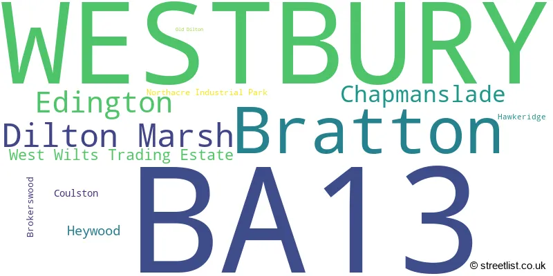
The largest settlement in the BA13 postal code is WESTBURY followed by Dilton Marsh, and Bratton.
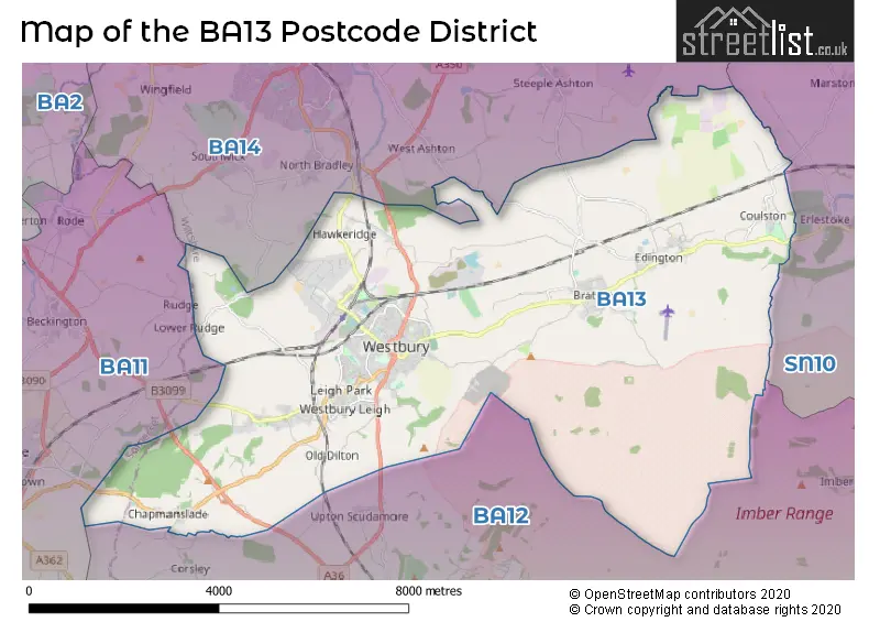
The BA13 Postcode shares a border with SN10 (DEVIZES, Market Lavington, Potterne), BA14 (TROWBRIDGE, Hilperton, Southwick) and BA12 (WARMINSTER, Mere, Codford).
The BA13 postcode district in Wiltshire, England consists primarily of the settlement of Westbury, with a high count of 326. Other significant settlements within the district include Dilton Marsh and Old Dilton. The county for this postcode district is Wiltshire. The post town associated with the highest number of postcodes is also Westbury.
For the district BA13, we have data on 4 postcode sectors. Here's a breakdown: The sector BA13 2, covers Westbury in Wiltshire. The sector BA13 3, covers Westbury in Wiltshire. The sector BA13 4, covers Bratton and Dilton Marsh and Westbury and Edington in Wiltshire. The sector BA13 9 is non-geographic. It's often designated for PO Boxes, large organisations, or special services.

Map of the BA13 Postcode District
Explore the BA13 postcode district by using our free interactive map.
When it comes to local government, postal geography often disregards political borders. However, for a breakdown in the BA13 District: the district mostly encompasses the Wiltshire area with a total of 633 postcodes.
Weather Forecast for BA13
Press Button to Show Forecast for Westbury (Wiltshire)
| Time Period | Icon | Description | Temperature | Rain Probability | Wind |
|---|---|---|---|---|---|
| 06:00 to 09:00 | Cloudy | 6.0°C (feels like 3.0°C) | 16.00% | NE 9 mph | |
| 09:00 to 12:00 | Overcast | 7.0°C (feels like 4.0°C) | 15.00% | ENE 11 mph | |
| 12:00 to 15:00 | Cloudy | 10.0°C (feels like 7.0°C) | 13.00% | NE 11 mph | |
| 15:00 to 18:00 | Cloudy | 11.0°C (feels like 8.0°C) | 13.00% | NE 11 mph | |
| 18:00 to 21:00 | Cloudy | 10.0°C (feels like 7.0°C) | 15.00% | NE 11 mph | |
| 21:00 to 00:00 | Overcast | 8.0°C (feels like 5.0°C) | 25.00% | NNE 11 mph |
Press Button to Show Forecast for Westbury (Wiltshire)
| Time Period | Icon | Description | Temperature | Rain Probability | Wind |
|---|---|---|---|---|---|
| 00:00 to 03:00 | Heavy rain | 7.0°C (feels like 4.0°C) | 85.00% | NNE 11 mph | |
| 03:00 to 06:00 | Heavy rain | 6.0°C (feels like 3.0°C) | 80.00% | N 13 mph | |
| 06:00 to 09:00 | Heavy rain | 6.0°C (feels like 3.0°C) | 84.00% | NNW 11 mph | |
| 09:00 to 12:00 | Light rain | 7.0°C (feels like 4.0°C) | 59.00% | NNW 11 mph | |
| 12:00 to 15:00 | Light rain | 9.0°C (feels like 6.0°C) | 48.00% | NW 11 mph | |
| 15:00 to 18:00 | Cloudy | 10.0°C (feels like 8.0°C) | 14.00% | WNW 9 mph | |
| 18:00 to 21:00 | Partly cloudy (day) | 10.0°C (feels like 8.0°C) | 5.00% | WSW 9 mph | |
| 21:00 to 00:00 | Clear night | 7.0°C (feels like 5.0°C) | 1.00% | WSW 7 mph |
Press Button to Show Forecast for Westbury (Wiltshire)
| Time Period | Icon | Description | Temperature | Rain Probability | Wind |
|---|---|---|---|---|---|
| 00:00 to 03:00 | Clear night | 5.0°C (feels like 3.0°C) | 1.00% | SW 7 mph | |
| 03:00 to 06:00 | Clear night | 4.0°C (feels like 2.0°C) | 1.00% | SSW 7 mph | |
| 06:00 to 09:00 | Sunny day | 6.0°C (feels like 4.0°C) | 2.00% | S 7 mph | |
| 09:00 to 12:00 | Partly cloudy (day) | 11.0°C (feels like 8.0°C) | 3.00% | S 13 mph | |
| 12:00 to 15:00 | Cloudy | 13.0°C (feels like 10.0°C) | 10.00% | S 16 mph | |
| 15:00 to 18:00 | Partly cloudy (day) | 13.0°C (feels like 10.0°C) | 4.00% | S 16 mph | |
| 18:00 to 21:00 | Sunny day | 12.0°C (feels like 9.0°C) | 5.00% | S 11 mph | |
| 21:00 to 00:00 | Clear night | 9.0°C (feels like 6.0°C) | 3.00% | SSE 9 mph |
Press Button to Show Forecast for Westbury (Wiltshire)
| Time Period | Icon | Description | Temperature | Rain Probability | Wind |
|---|---|---|---|---|---|
| 00:00 to 03:00 | Clear night | 8.0°C (feels like 6.0°C) | 3.00% | SE 9 mph | |
| 03:00 to 06:00 | Clear night | 8.0°C (feels like 6.0°C) | 3.00% | SE 9 mph | |
| 06:00 to 09:00 | Sunny day | 9.0°C (feels like 6.0°C) | 5.00% | SE 9 mph | |
| 09:00 to 12:00 | Partly cloudy (day) | 12.0°C (feels like 10.0°C) | 12.00% | SE 13 mph | |
| 12:00 to 15:00 | Partly cloudy (day) | 14.0°C (feels like 11.0°C) | 13.00% | SSE 13 mph | |
| 15:00 to 18:00 | Cloudy | 15.0°C (feels like 12.0°C) | 16.00% | SSE 13 mph | |
| 18:00 to 21:00 | Cloudy | 13.0°C (feels like 12.0°C) | 13.00% | SSE 9 mph | |
| 21:00 to 00:00 | Cloudy | 10.0°C (feels like 9.0°C) | 10.00% | SE 7 mph |
Where is the BA13 Postcode District?
The BA13 postcode district is located in the town of Westbury, which is near several other towns. To the South, there is Warminster which is approximately 4.14 miles away. To the Northwest, there is Trowbridge which is around 4.34 miles away. To the North, there is Melksham which is approximately 7.70 miles away. To the West, there is Frome which is around 8.67 miles away. And to the Northeast, there is Devizes which is approximately 9.49 miles away. Additionally, the BA13 postcode district is situated about 89.21 miles away from the center of London.
The district is within the post town of WESTBURY.
The sector has postcodes within the nation of England.
The BA13 Postcode District is in the Wiltshire region of Gloucestershire, Wiltshire and Bath/Bristol area within the South West (England).
| Postcode Sector | Delivery Office |
|---|---|
| BA13 2 | Westbury Delivery Office |
| BA13 3 | Westbury Delivery Office |
| BA13 4 | Westbury Delivery Office |
| B | A | 1 | 3 | - | X | X | X |
| B | A | 1 | 3 | Space | Numeric | Letter | Letter |
Current Monthly Rental Prices
| # Bedrooms | Min Price | Max Price | Avg Price |
|---|---|---|---|
| £792 | £792 | £792 | |
| 1 | £695 | £700 | £697 |
| 2 | £850 | £850 | £850 |
| 3 | £925 | £1,250 | £1,108 |
| 4 | £1,500 | £2,500 | £2,100 |
Current House Prices
| # Bedrooms | Min Price | Max Price | Avg Price |
|---|---|---|---|
| 3 | £625,000 | £625,000 | £625,000 |
| 4 | £550,000 | £749,950 | £604,463 |
| 5 | £650,000 | £1,350,000 | £998,333 |
| 6 | £1,950,000 | £2,250,000 | £2,100,000 |
| 7 | £1,100,000 | £1,100,000 | £1,100,000 |
Estate Agents who Operate in the BA13 District
| Logo | Name | Brand Name | Address | Contact Number | Total Properties |
|---|---|---|---|---|---|
 | Westbury | Martin & Co | 7 Palomino Place, Westbury, BA13 3SD | 01373 485183 | 68 |
 | Westbury | Davies & Davies | Westbury | 01373 481109 | 53 |
 | Westbury | Allen & Harris | 15a Warminster Road, Westbury, Wiltshire, BA13 3PD | 01375 803704 | 31 |
 | Trowbridge | Town & Country Estates | 9 Fore Street Trowbridge BA14 8HD | 01225 434415 | 9 |
 | Plymouth | Sensible Move | 46 Howard Road, Pomphlett, Plymouth, PL9 7DT | 01752 741813 | 4 |
| Type of Property | 2018 Average | 2018 Sales | 2017 Average | 2017 Sales | 2016 Average | 2016 Sales | 2015 Average | 2015 Sales |
|---|---|---|---|---|---|---|---|---|
| Detached | £353,384 | 140 | £327,302 | 150 | £337,646 | 158 | £311,202 | 175 |
| Semi-Detached | £228,680 | 131 | £216,555 | 137 | £211,838 | 139 | £183,349 | 130 |
| Terraced | £193,927 | 130 | £187,389 | 126 | £177,484 | 130 | £157,268 | 146 |
| Flats | £145,107 | 43 | £130,062 | 39 | £113,052 | 51 | £117,559 | 61 |