The BD6 1 postcode sector is within the county of West Yorkshire.
Did you know? According to the 2021 Census, the BD6 1 postcode sector is home to a bustling 8,799 residents!
Given that each sector allows for 400 unique postcode combinations. Letters C, I, K, M, O and V are not allowed in the last two letters of a postcode. With 249 postcodes already in use, this leaves 151 units available.
The largest settlements in the BD6 1 postal code are BRADFORD and Wibsey.
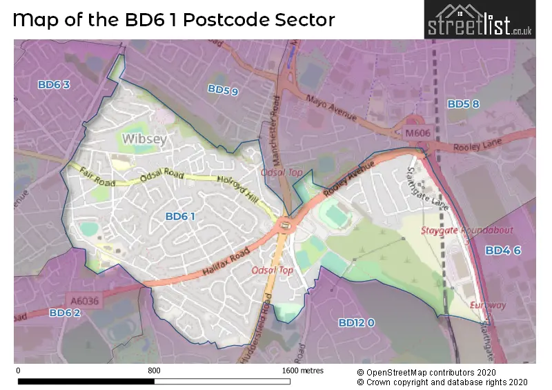
The BD6 1 Postcode shares a border with BD5 8 (BRADFORD, West Bowling), BD6 3 (BRADFORD, Buttershaw, Wibsey), BD12 0 (Low Moor, BRADFORD), BD4 6 (BRADFORD, Bierley, Euroway Industrial Estate), BD5 9 (BRADFORD) and BD6 2 (BRADFORD, Buttershaw).
The sector is within the post town of BRADFORD.
BD6 1 is a postcode sector within the BD6 postcode district which is within the BD Bradford postcode area.
The Royal Mail delivery office for the BD6 1 postal sector is the Bradford South Delivery Office.
The area of the BD6 1 postcode sector is 0.83 square miles which is 2.16 square kilometres or 532.58 square acres.
The BD6 1 postcode sector is crossed by the M606 motorway.

Map of the BD6 1 Postcode Sector
Explore the BD6 1 postcode sector by using our free interactive map.
| B | D | 6 | - | 1 | X | X |
| B | D | 6 | Space | 1 | Letter | Letter |
Official List of Streets
Wibsey (13 Streets)
BRADFORD (151 Streets)
Unofficial Streets or Alternative Spellings
BRADFORD
BUTTERSHAW LANE MANCHESTER ROAD SOMERVILLE PARK TRUNCLIFFE WATTY HALL ROAD WHITE LANE TOP ADAM STREET BACK MARKET STREET BRADLAUGH ROAD CAPA TERRACE GLENFIELD AVENUE ODSAL PLACE ODSAL TOP PEARSON ROAD (WEST) POT HOUSE CLOSE POTHOUSE ROAD ST ABBS GATE ST ENOCHS ROAD STAYGATE ROUNDABOUT SUNNY LEA TERRACE SUTCLIFFE TERRACE THE OLD BARNLow Moor
CLECKHEATON ROAD HUDDERSFIELD ROAD NETHERLANDS AVENUE WYNFORD WAYWibsey
HARBOUR ROADWest Bowling
ROOLEY LANEButtershaw
HALIFAX ROADWeather Forecast for BD6 1
Press Button to Show Forecast for Wibsey
| Time Period | Icon | Description | Temperature | Rain Probability | Wind |
|---|---|---|---|---|---|
| 06:00 to 09:00 | Heavy rain | 4.0°C (feels like 0.0°C) | 90.00% | NNE 16 mph | |
| 09:00 to 12:00 | Heavy rain | 4.0°C (feels like -1.0°C) | 90.00% | NNW 16 mph | |
| 12:00 to 15:00 | Heavy rain | 4.0°C (feels like 0.0°C) | 88.00% | NW 16 mph | |
| 15:00 to 18:00 | Heavy rain | 6.0°C (feels like 2.0°C) | 76.00% | WNW 16 mph | |
| 18:00 to 21:00 | Cloudy | 7.0°C (feels like 3.0°C) | 17.00% | W 13 mph | |
| 21:00 to 00:00 | Clear night | 5.0°C (feels like 1.0°C) | 2.00% | WSW 11 mph |
Press Button to Show Forecast for Wibsey
| Time Period | Icon | Description | Temperature | Rain Probability | Wind |
|---|---|---|---|---|---|
| 00:00 to 03:00 | Clear night | 4.0°C (feels like 1.0°C) | 2.00% | SW 11 mph | |
| 03:00 to 06:00 | Partly cloudy (night) | 4.0°C (feels like 0.0°C) | 41.00% | SW 11 mph | |
| 06:00 to 09:00 | Partly cloudy (day) | 5.0°C (feels like 2.0°C) | 39.00% | SSW 9 mph | |
| 09:00 to 12:00 | Partly cloudy (day) | 10.0°C (feels like 7.0°C) | 6.00% | SSW 13 mph | |
| 12:00 to 15:00 | Cloudy | 12.0°C (feels like 9.0°C) | 11.00% | S 16 mph | |
| 15:00 to 18:00 | Cloudy | 13.0°C (feels like 10.0°C) | 13.00% | S 16 mph | |
| 18:00 to 21:00 | Partly cloudy (day) | 11.0°C (feels like 9.0°C) | 9.00% | S 11 mph | |
| 21:00 to 00:00 | Cloudy | 9.0°C (feels like 7.0°C) | 10.00% | SSE 11 mph |
Press Button to Show Forecast for Wibsey
| Time Period | Icon | Description | Temperature | Rain Probability | Wind |
|---|---|---|---|---|---|
| 00:00 to 03:00 | Cloudy | 8.0°C (feels like 5.0°C) | 7.00% | SSE 9 mph | |
| 03:00 to 06:00 | Partly cloudy (night) | 7.0°C (feels like 4.0°C) | 4.00% | SE 9 mph | |
| 06:00 to 09:00 | Sunny day | 7.0°C (feels like 4.0°C) | 2.00% | ESE 9 mph | |
| 09:00 to 12:00 | Partly cloudy (day) | 11.0°C (feels like 8.0°C) | 2.00% | ESE 11 mph | |
| 12:00 to 15:00 | Partly cloudy (day) | 14.0°C (feels like 11.0°C) | 4.00% | SE 13 mph | |
| 15:00 to 18:00 | Cloudy | 15.0°C (feels like 12.0°C) | 9.00% | SE 13 mph | |
| 18:00 to 21:00 | Partly cloudy (day) | 13.0°C (feels like 11.0°C) | 8.00% | ESE 9 mph | |
| 21:00 to 00:00 | Clear night | 10.0°C (feels like 9.0°C) | 8.00% | E 7 mph |
Press Button to Show Forecast for Wibsey
| Time Period | Icon | Description | Temperature | Rain Probability | Wind |
|---|---|---|---|---|---|
| 00:00 to 03:00 | Overcast | 9.0°C (feels like 7.0°C) | 15.00% | ENE 4 mph | |
| 03:00 to 06:00 | Overcast | 9.0°C (feels like 7.0°C) | 22.00% | ENE 4 mph | |
| 06:00 to 09:00 | Overcast | 9.0°C (feels like 8.0°C) | 23.00% | ENE 7 mph | |
| 09:00 to 12:00 | Overcast | 11.0°C (feels like 10.0°C) | 21.00% | ENE 7 mph | |
| 12:00 to 15:00 | Overcast | 14.0°C (feels like 12.0°C) | 17.00% | ENE 9 mph | |
| 15:00 to 18:00 | Light rain shower (day) | 15.0°C (feels like 13.0°C) | 32.00% | ENE 9 mph | |
| 18:00 to 21:00 | Partly cloudy (day) | 13.0°C (feels like 11.0°C) | 8.00% | ENE 9 mph | |
| 21:00 to 00:00 | Overcast | 10.0°C (feels like 8.0°C) | 12.00% | NE 7 mph |
Schools and Places of Education Within the BD6 1 Postcode Sector
St Paul's CofE Primary School
Voluntary aided school
St Paul's Avenue, Bradford, West Yorkshire, BD6 1ST
Head: Mrs Catherine Palmer
Ofsted Rating: Good
Inspection: 2020-02-12 (1537 days ago)
Website: Visit St Paul's CofE Primary School Website
Phone: 01274679183
Number of Pupils: 205
St Winefride's Catholic Primary School, A Voluntary Academy
Academy converter
St Paul's Avenue, Bradford, West Yorkshire, BD6 1SR
Head: Mr Ben Lavin
Ofsted Rating: Good
Inspection: 2019-04-03 (1852 days ago)
Website: Visit St Winefride's Catholic Primary School, A Voluntary Academy Website
Phone: 01274677705
Number of Pupils: 415
Wibsey Primary School
Community school
North Road, Bradford, West Yorkshire, BD6 1RL
Head: Mr Nigel Cooper
Ofsted Rating: Good
Inspection: 2023-04-26 (368 days ago)
Website: Visit Wibsey Primary School Website
Phone: 01274678016
Number of Pupils: 684
House Prices in the BD6 1 Postcode Sector
| Type of Property | 2018 Average | 2018 Sales | 2017 Average | 2017 Sales | 2016 Average | 2016 Sales | 2015 Average | 2015 Sales |
|---|---|---|---|---|---|---|---|---|
| Detached | £198,000 | 8 | £183,967 | 23 | £186,106 | 25 | £183,450 | 23 |
| Semi-Detached | £116,577 | 66 | £117,335 | 74 | £122,649 | 69 | £120,585 | 85 |
| Terraced | £84,602 | 63 | £92,833 | 54 | £91,971 | 47 | £87,954 | 45 |
| Flats | £58,333 | 3 | £91,333 | 3 | £70,817 | 3 | £52,750 | 4 |
Important Postcodes BD6 1 in the Postcode Sector
BD6 1AT is the postcode for Odsal Resource Centre, Community Centre, 6 Sunny Lea Terrace, Odsal Road
BD6 1DJ is the postcode for West Yorkshire Fire & Rescue Service, Odsal Fire Station, Huddersfield Road
BD6 1DY is the postcode for NORMAN LODGE, City of Bradford Metropolitan District Council, Home & Day Centre, Glenroyd Avenue, and Home And Day Centre, Norman Lodge, 1a Glenroyd Avenue
BD6 1EA is the postcode for Chellow Heights School, Netherlands Avenue, and SOUTH CAMPUS, Chellow Heights School, Netherlands Avenue
BD6 1EZ is the postcode for Richard Dunn Sports Centre, Rooley Avenue
BD6 1RL is the postcode for RECEPTION BLOCK, Wibsey Primary School, North Road, and Wibsey Primary School, North Road
BD6 1SR is the postcode for ST WINIFRIDES CATHOLIC PRIMARY SCHOOL, ST PAULS AVENUE, ST WINIFRIDES CATHOLIC PRIMARY SCHOOL, ST PAULS AVENUE, BRADFORD, and St. Winifreds RC School, St. Pauls Avenue
BD6 1ST is the postcode for St. Pauls Primary School, St. Pauls Avenue
| The BD6 1 Sector is within these Local Authorities |
|
|---|---|
| The BD6 1 Sector is within these Counties |
|
| The BD6 1 Sector is within these Water Company Areas |
|