
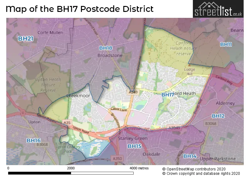
Map of the Postcode District
Explore the postcode district by using our interactive map.
Circles represent recorded crime; the larger the circle, the higher the crime rates.
Your support helps keep this site running!
If you enjoy using this website, consider buying me a coffee to help cover hosting costs.
The postcode district located in the BH Bournemouth postal area , BH17 has a population of 23,043 residents according to the 2021 England and Wales Census.
The area of the district is 3.83 square miles (9.93 square kilometers or 2,454.29 acres).
Where is the BH17 District?
To give you an idea where the district is located we have created the following table showing nearby towns.
Nearest Towns to BH17
| Town | Distance (miles) | Direction |
|---|---|---|
| Poole | 2.04 | S |
| Wimborne Minster | 3.53 | N |
| Bournemouth | 4.98 | ESE |
| Ferndown | 5.42 | NE |
| Wareham | 7.09 | SW |
| Christchurch | 8.80 | E |
| Swanage | 9.76 | S |
| Verwood | 10.26 | NNE |
| Ringwood | 10.73 | NE |
| Blandford Forum | 10.99 | NW |
| New Milton | 14.33 | E |
| Fordingbridge | 14.96 | NE |
| Sturminster Newton | 18.77 | NW |
| Lymington | 19.29 | E |
| Shaftesbury | 20.12 | NNW |
| Dorchester | 20.15 | W |
| Yarmouth | 21.45 | E |
| Stalbridge | 22.67 | NW |
| Weymouth | 22.99 | WSW |
| Wilton | 23.49 | NNE |
The post town for this district is POOLE.
Postcode Information for District BH17 (Total Geographical Postcodes: 485)
| Location | Post Town | Sector | Number of Postcodes |
|---|---|---|---|
| POOLE | POOLE | BH17 7 | 188 |
| POOLE | POOLE | BH17 8 | 121 |
| POOLE | POOLE | BH17 9 | 105 |
| Nuffield Industrial Estate | POOLE | BH17 0 | 54 |
| POOLE | POOLE | BH17 0 | 15 |
| Upton | POOLE | BH17 7 | 1 |
| Waterloo | POOLE | BH17 7 | 1 |
Retail and Shopping in BH17
Street
Town
Locality
Number of Shops
Central Postcode
View on Google Maps
WATERLOO ROAD
POOLE
14
BH17 7LG
View on Google Maps
ADASTRAL SQUARE
POOLE
12
BH17 8SA
View on Google Maps
CULLIFORD CRESCENT
POOLE
11
BH17 9DW
View on Google Maps
MARSHAL ROAD
POOLE
9
BH17 7EZ
View on Google Maps
| Street | Town | Locality | Number of Shops | Central Postcode | View on Google Maps |
|---|---|---|---|---|---|
| WATERLOO ROAD | POOLE | 14 | BH17 7LG | View on Google Maps | |
| ADASTRAL SQUARE | POOLE | 12 | BH17 8SA | View on Google Maps | |
| CULLIFORD CRESCENT | POOLE | 11 | BH17 9DW | View on Google Maps | |
| MARSHAL ROAD | POOLE | 9 | BH17 7EZ | View on Google Maps |
The primary settlement in the BH17 postcode district is Poole, located in the county of Dorset in England. Other significant settlements within the district include Nuffield Industrial Estate, Upton, and Waterloo. The main post town in the district is also Poole.
When it comes to local government, postal geography often disregards political borders. However, this district intersects the following councils: the district mostly encompasses the Bournemouth, Christchurch and Poole area with a total of 438 postal codes.
The largest settlements in the BH17 postal code are POOLE and Nuffield Industrial Estate.
The postcode area has a boundary with Poole Harbour.
The BH17 Postcode shares a border with BH11 (BOURNEMOUTH, Bearwood), BH18 (BROADSTONE), BH16 (POOLE, Lytchett Matravers, Upton) and BH15 (POOLE).


Schools in the Sector
Parkstone Grammar School
Phase: Secondary
Address: Sopers Lane , Poole
Postcode: BH17 7EP
Headteacher: Mr David Hallsworth (Headteacher)
Ofsted Rating: Outstanding
Hillbourne Primary School
Phase: Primary
Address: Kitchener Crescent , Poole
Postcode: BH17 7HX
Headteacher: Ms Helen Roderick (Headteacher)
Ofsted Rating: Requires improvement
Ad Astra Infant School
Phase: Primary
Address: Sherborn Crescent , Canford Heath , Poole
Postcode: BH17 8AP
Headteacher: Mrs Clare Tantrum (Executive Headteacher)
Ofsted Rating: Good
Canford Heath Infant School
Phase: Primary
Address: Learoyd Road , Canford Heath , Poole
Postcode: BH17 8PJ
Headteacher: Mrs Kate Carter (Executive Headteacher)
Ofsted Rating: Outstanding
Longspee Academy
Phase: Not applicable
Address: Learoyd Road , Canford Heath , Poole
Postcode: BH17 8PJ
Headteacher: Gavin O'connell (Associate Principal)
Ofsted Rating: Outstanding
Canford Heath Infant School
Phase: Primary
Address: Learoyd Road , Canford Heath , Poole
Postcode: BH17 8PJ
Headteacher: Mrs Laurin Palmer (Executive Headteacher)
Ofsted Rating: Outstanding
Canford Heath Junior School
Phase: Primary
Address: Learoyd Road , Canford Heath , Poole
Postcode: BH17 8PJ
Headteacher: Mr Mark Wilson (Executive Headteacher)
Ofsted Rating: Good
Magna Academy
Phase: Secondary
Address: Ashdown Close , Adastral Road , Canford Heath , Poole
Postcode: BH17 8RE
Headteacher: Ms Natasha Ullah ()
Ofsted Rating: Good
Haymoor Junior School
Phase: Primary
Address: Ashdown Close , Canford Heath , Poole
Postcode: BH17 8WG
Headteacher: Miss Lucy Waterhouse (Executive Headteacher)
Ofsted Rating: Good
Poole Grammar School
Phase: Secondary
Address: Gravel Hill , Poole
Postcode: BH17 9JU
Headteacher: Dr Amanda Smith (Headteacher)
Ofsted Rating: Good
Montacute School
Phase: Not applicable
Address: 3 Canford Heath Road , Poole
Postcode: BH17 9NG
Headteacher: Mrs Ginny Bellard (Headteacher)
Ofsted Rating: Good
Stations in the Sector
No stations found in this postcode district.
Accessable Motorway Junctions
M27 J1
Average Driving Time from within the district: 28.30
Average Driving Distance: 23.44
Number of Postcodes that can access the Motorway Junction: 438
M27 J2
Average Driving Time from within the district: 31.11
Average Driving Distance: 26.38
Number of Postcodes that can access the Motorway Junction: 438
M27 J3
Average Driving Time from within the district: 33.58
Average Driving Distance: 28.93
Number of Postcodes that can access the Motorway Junction: 438
M271 J1
Average Driving Time from within the district: 34.60
Average Driving Distance: 29.95
Number of Postcodes that can access the Motorway Junction: 438
Weather Forecast for Canford Heath
| Time Period | Icon | Description | Temperature | Rain Probability | Wind |
|---|---|---|---|---|---|
| 12:00 to 15:00 | Light rain shower (day) | 15.0°C (feels like 14.0°C) | 35.00% | WSW 11 mph | |
| 15:00 to 18:00 | Cloudy | 16.0°C (feels like 15.0°C) | 7.00% | WSW 9 mph | |
| 18:00 to 21:00 | Clear night | 13.0°C (feels like 13.0°C) | 1.00% | WSW 4 mph | |
| 21:00 to 00:00 | Clear night | 11.0°C (feels like 11.0°C) | 0.00% | WNW 2 mph |
| Time Period | Icon | Description | Temperature | Rain Probability | Wind |
|---|---|---|---|---|---|
| 00:00 to 03:00 | Partly cloudy (night) | 10.0°C (feels like 10.0°C) | 1.00% | S 4 mph | |
| 03:00 to 06:00 | Partly cloudy (night) | 10.0°C (feels like 10.0°C) | 1.00% | SSE 4 mph | |
| 06:00 to 09:00 | Partly cloudy (night) | 10.0°C (feels like 10.0°C) | 1.00% | SSE 2 mph | |
| 09:00 to 12:00 | Partly cloudy (day) | 14.0°C (feels like 13.0°C) | 2.00% | S 4 mph | |
| 12:00 to 15:00 | Partly cloudy (day) | 16.0°C (feels like 14.0°C) | 3.00% | SSW 11 mph | |
| 15:00 to 18:00 | Partly cloudy (day) | 15.0°C (feels like 14.0°C) | 1.00% | S 9 mph | |
| 18:00 to 21:00 | Clear night | 13.0°C (feels like 12.0°C) | 0.00% | SE 7 mph | |
| 21:00 to 00:00 | Partly cloudy (night) | 14.0°C (feels like 12.0°C) | 1.00% | SSE 9 mph |
| Time Period | Icon | Description | Temperature | Rain Probability | Wind |
|---|---|---|---|---|---|
| 00:00 to 03:00 | Clear night | 14.0°C (feels like 12.0°C) | 0.00% | SSE 11 mph | |
| 03:00 to 06:00 | Clear night | 13.0°C (feels like 11.0°C) | 1.00% | SSE 11 mph | |
| 06:00 to 09:00 | Clear night | 13.0°C (feels like 11.0°C) | 1.00% | SSE 11 mph | |
| 09:00 to 12:00 | Cloudy | 14.0°C (feels like 12.0°C) | 7.00% | SSE 16 mph | |
| 12:00 to 15:00 | Cloudy | 15.0°C (feels like 13.0°C) | 12.00% | S 16 mph | |
| 15:00 to 18:00 | Cloudy | 16.0°C (feels like 13.0°C) | 12.00% | S 16 mph | |
| 18:00 to 21:00 | Partly cloudy (night) | 16.0°C (feels like 13.0°C) | 18.00% | S 16 mph | |
| 21:00 to 00:00 | Heavy rain shower (night) | 16.0°C (feels like 13.0°C) | 59.00% | SSW 18 mph |
| Time Period | Icon | Description | Temperature | Rain Probability | Wind |
|---|---|---|---|---|---|
| 00:00 to 03:00 | Heavy rain shower (night) | 14.0°C (feels like 11.0°C) | 58.00% | SW 13 mph | |
| 03:00 to 06:00 | Cloudy | 13.0°C (feels like 11.0°C) | 13.00% | SW 13 mph | |
| 06:00 to 09:00 | Clear night | 12.0°C (feels like 10.0°C) | 4.00% | SW 11 mph | |
| 09:00 to 12:00 | Partly cloudy (day) | 12.0°C (feels like 10.0°C) | 7.00% | SW 13 mph | |
| 12:00 to 15:00 | Partly cloudy (day) | 13.0°C (feels like 10.0°C) | 33.00% | WSW 16 mph | |
| 15:00 to 18:00 | Light rain shower (day) | 13.0°C (feels like 10.0°C) | 35.00% | WSW 16 mph | |
| 18:00 to 21:00 | Clear night | 11.0°C (feels like 8.0°C) | 1.00% | W 13 mph | |
| 21:00 to 00:00 | Clear night | 10.0°C (feels like 7.0°C) | 1.00% | WSW 11 mph |
| Time Period | Icon | Description | Temperature | Rain Probability | Wind |
|---|---|---|---|---|---|
| 00:00 to 03:00 | Clear night | 10.0°C (feels like 7.0°C) | 1.00% | WSW 11 mph | |
| 03:00 to 06:00 | Partly cloudy (night) | 10.0°C (feels like 7.0°C) | 2.00% | WSW 11 mph | |
| 06:00 to 09:00 | Partly cloudy (night) | 10.0°C (feels like 7.0°C) | 5.00% | WSW 11 mph | |
| 09:00 to 12:00 | Sunny day | 12.0°C (feels like 9.0°C) | 7.00% | WSW 13 mph | |
| 12:00 to 15:00 | Cloudy | 14.0°C (feels like 11.0°C) | 11.00% | WSW 16 mph | |
| 15:00 to 18:00 | Cloudy | 14.0°C (feels like 11.0°C) | 13.00% | WSW 13 mph | |
| 18:00 to 21:00 | Cloudy | 13.0°C (feels like 10.0°C) | 11.00% | WSW 13 mph | |
| 21:00 to 00:00 | Partly cloudy (night) | 12.0°C (feels like 10.0°C) | 6.00% | WSW 11 mph |
| Postal Sector | Delivery Office |
|---|---|
| BH17 0 | Alder Hills Delivery Office |
| BH17 7 | Alder Hills Delivery Office |
| BH17 8 | Alder Hills Delivery Office |
| BH17 9 | Alder Hills Delivery Office |
| B | H | 1 | 7 | - | X | X | X |
| B | H | 1 | 7 | Space | Numeric | Letter | Letter |
Street List for the BH17 District
Current Monthly Rental Prices
| # Bedrooms | Min Price | Max Price | Avg Price |
|---|---|---|---|
| 2 | £1,250 | £1,250 | £1,250 |
| 3 | £1,050 | £1,800 | £1,450 |
| 4 | £1,750 | £1,800 | £1,775 |
Current House Prices
| # Bedrooms | Min Price | Max Price | Avg Price |
|---|---|---|---|
| 2 | £450,000 | £450,000 | £450,000 |
| 3 | £425,000 | £545,000 | £495,000 |
| 4 | £415,000 | £525,000 | £477,300 |
| 5 | £400,000 | £599,950 | £539,993 |
Estate Agents
| Logo | Name | Brand Name | Address | Contact Number |
|---|---|---|---|---|
 | Poole | Meyers Estate Agents | Unit 11, New Fields Business Park, 2 Stinsford Road, Poole, BH17 0NF | 01202 149442 |
 | Canford Heath | Austin & Wyatt | 15 Adastral Square, Canford Heath, Poole, Dorset, BH17 8SA | 020 3835 3434 |
 | Broadstone | Goadsby | 177 Lower Blandford Road, Broadstone, BH18 8DH | 01202 125901 |
 | Poole | Thacker & Revitt | 478 Ashley Road, Parkstone, Poole, BH14 0AD | 01202 748999 |
 | Broadstone | Wrights Estate Agents | 211 The Broadway, Broadstone, BH18 8DN | 020 3892 9558 |
Yearly House Price Averages for the District
| Type of Property | 2018 Average | 2018 Sales | 2017 Average | 2017 Sales | 2016 Average | 2016 Sales | 2015 Average | 2015 Sales |
|---|---|---|---|---|---|---|---|---|
| Detached | £332,855 | 117 | £325,461 | 176 | £309,966 | 148 | £291,777 | 117 |
| Semi-Detached | £268,266 | 98 | £265,869 | 104 | £248,981 | 113 | £224,502 | 98 |
| Terraced | £227,160 | 114 | £231,438 | 124 | £217,466 | 137 | £193,838 | 116 |
| Flats | £145,224 | 45 | £150,800 | 58 | £142,889 | 41 | £125,651 | 39 |