The BH23 5 postcode sector stands on the Dorset and Hampshire border.
Did you know? According to the 2021 Census, the BH23 5 postcode sector is home to a bustling 7,349 residents!
Given that each sector allows for 400 unique postcode combinations. Letters C, I, K, M, O and V are not allowed in the last two letters of a postcode. With 230 postcodes already in use, this leaves 170 units available.
The largest settlement in the BH23 5 postal code is Highcliffe followed by Walkford, and CHRISTCHURCH.
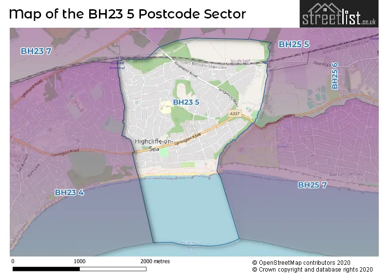
The BH23 5 Postcode shares a border with BH23 4 (CHRISTCHURCH, Highcliffe), BH23 7 (Burton, Sopley, Hinton), BH25 5 (NEW MILTON, Ossemsley), BH25 6 (NEW MILTON) and BH25 7 (Barton On Sea, NEW MILTON).
The sector is within the post town of CHRISTCHURCH.
BH23 5 is a postcode sector within the BH25 postcode district which is within the BH Bournemouth postcode area.
The Royal Mail delivery office for the BH23 5 postal sector is the New Milton Delivery Office.
The area of the BH23 5 postcode sector is 1.42 square miles which is 3.69 square kilometres or 911.30 square acres.

Map of the BH23 5 Postcode Sector
Explore the BH23 5 postcode sector by using our free interactive map.
| B | H | 2 | 3 | - | 5 | X | X |
| B | H | 2 | 3 | Space | 5 | Letter | Letter |
Official List of Streets
Highcliffe (72 Streets)
Walkford (37 Streets)
Unofficial Streets or Alternative Spellings
NEW MILTON
CHRISTCHURCH ROAD GORE ROAD WALKFORD LANEHighcliffe
ROTHESAY DRIVE BUCEHAYES CLOSE GORDON MOUNT GRENVILLE GARDENS HASLEMERE PLACE JAYS COURT MARRYAT COURT MILESTONE ROUNDABOUT MILVERTON CLOSE QUINTIN CLOSE THE LAWNSWalkford
CHEWTON MEWSCHRISTCHURCH
CARISBROOKE WAY NEA ROAD WOODHAYES AVENUEBransgore
RINGWOOD ROADSchools and Places of Education Within the BH23 5 Postcode Sector
Highcliffe St Mark Primary School
Foundation school
Greenways, Christchurch, Dorset, BH23 5AZ
Head: Mrs Claire Barker
Ofsted Rating: Good
Inspection: 2018-07-18 (2147 days ago)
Website: Visit Highcliffe St Mark Primary School Website
Phone: 01425273029
Number of Pupils: 652
House Prices in the BH23 5 Postcode Sector
| Type of Property | 2018 Average | 2018 Sales | 2017 Average | 2017 Sales | 2016 Average | 2016 Sales | 2015 Average | 2015 Sales |
|---|---|---|---|---|---|---|---|---|
| Detached | £536,573 | 86 | £508,178 | 112 | £486,295 | 104 | £450,323 | 112 |
| Semi-Detached | £392,838 | 21 | £325,902 | 23 | £319,711 | 14 | £306,091 | 16 |
| Terraced | £323,689 | 18 | £310,785 | 24 | £294,220 | 22 | £262,856 | 18 |
| Flats | £278,927 | 99 | £240,818 | 84 | £242,524 | 103 | £234,913 | 119 |
Important Postcodes BH23 5 in the Postcode Sector
BH23 5AZ is the postcode for BLOCK B - INFANTS, Highcliffe St Mark Primary School, Greenways, Highcliffe St Mark Primary School, Greenways, and BLOCK A - JUNIORS, Highcliffe St Mark Primary School, Greenways
BH23 5ET is the postcode for Highcliffe Medical Centre, Heila House, 248 Lymington Road, and Christchurch Day Centre, 250 Lymington Road
| The BH23 5 Sector is within these Local Authorities |
|
|---|---|
| The BH23 5 Sector is within these Counties |
|
| The BH23 5 Sector is within these Water Company Areas |
|