The BH6 5 postcode sector is within the county of Dorset.
Did you know? According to the 2021 Census, the BH6 5 postcode sector is home to a bustling 10,473 residents!
Given that each sector allows for 400 unique postcode combinations. Letters C, I, K, M, O and V are not allowed in the last two letters of a postcode. With 206 postcodes already in use, this leaves 194 units available.
The BH6 5 postal code covers the settlement of BOURNEMOUTH.
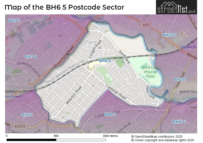
The BH6 5 Postcode shares a border with BH5 2 (BOURNEMOUTH), BH23 2 (CHRISTCHURCH), BH6 3 (BOURNEMOUTH), BH7 6 (BOURNEMOUTH) and BH23 1 (CHRISTCHURCH).
The sector is within the post town of BOURNEMOUTH.
BH6 5 is a postcode sector within the BH5 postcode district which is within the BH Bournemouth postcode area.
The Royal Mail delivery office for the BH6 5 postal sector is the unknown.
The area of the BH6 5 postcode sector is 0.78 square miles which is 2.03 square kilometres or 501.03 square acres.
Waterways within the BH6 5 postcode sector include the Stour.

Map of the BH6 5 Postcode Sector
Explore the BH6 5 postcode sector by using our free interactive map.
| B | H | 6 | - | 5 | X | X |
| B | H | 6 | Space | 5 | Letter | Letter |
Official List of Streets
BOURNEMOUTH (75 Streets)
Unofficial Streets or Alternative Spellings
Schools and Places of Education Within the BH6 5 Postcode Sector
Stourfield Infant School
Academy converter
Cranleigh Road, Bournemouth, Dorset, BH6 5JS
Head: Mrs Pauline Sweetman
Ofsted Rating: Requires improvement
Inspection: 2021-10-21 (945 days ago)
Website: Visit Stourfield Infant School Website
Phone: 01202424585
Number of Pupils: 304
Stourfield Junior School
Academy converter
Stourvale Road, Bournemouth, Dorset, BH6 5JG
Head: Miss Emma Rawson
Ofsted Rating: Good
Inspection: 2020-01-09 (1596 days ago)
Website: Visit Stourfield Junior School Website
Phone: 01202424554
Number of Pupils: 456
House Prices in the BH6 5 Postcode Sector
| Type of Property | 2018 Average | 2018 Sales | 2017 Average | 2017 Sales | 2016 Average | 2016 Sales | 2015 Average | 2015 Sales |
|---|---|---|---|---|---|---|---|---|
| Detached | £398,168 | 76 | £375,411 | 64 | £348,484 | 85 | £337,903 | 106 |
| Semi-Detached | £324,618 | 31 | £316,858 | 41 | £299,133 | 43 | £280,143 | 45 |
| Terraced | £285,375 | 8 | £246,250 | 8 | £269,989 | 9 | £270,403 | 19 |
| Flats | £199,634 | 56 | £178,042 | 78 | £181,121 | 65 | £168,373 | 78 |
Important Postcodes BH6 5 in the Postcode Sector
BH6 5AJ is the postcode for Douglas House, 19 Beaufort Road
BH6 5EJ is the postcode for Wallfield, 29 Castlemain Avenue
BH6 5JG is the postcode for Stourfield Junior School, Stourvale Road
BH6 5JS is the postcode for Stourfield Infant School, Cranleigh Road, and Stourfield Junior School, Cranleigh Road
| The BH6 5 Sector is within these Local Authorities |
|
|---|---|
| The BH6 5 Sector is within these Counties |
|
| The BH6 5 Sector is within these Water Company Areas |
|