The BL4 0 postcode sector is within the county of Greater Manchester.
Did you know? According to the 2021 Census, the BL4 0 postcode sector is home to a bustling 10,739 residents!
Given that each sector allows for 400 unique postcode combinations. Letters C, I, K, M, O and V are not allowed in the last two letters of a postcode. With 200 postcodes already in use, this leaves 200 units available.
The BL4 0 postal code covers the settlement of Farnworth.
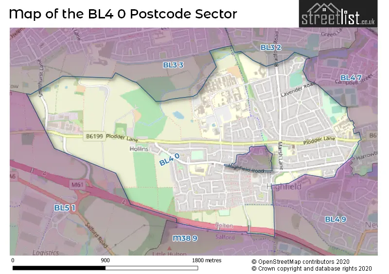
The BL4 0 Postcode shares a border with BL3 2 (BOLTON), BL3 3 (BOLTON), BL4 7 (Farnworth, Kearsley), BL4 9 (Farnworth, Kearsley), BL5 1 (BOLTON, Over Hulton) and M38 9 (Little Hulton).
The sector is within the post town of BOLTON.
BL4 0 is a postcode sector within the BL4 postcode district which is within the BL Bolton postcode area.
The Royal Mail delivery office for the BL4 0 postal sector is the unknown.
The area of the BL4 0 postcode sector is 1.31 square miles which is 3.38 square kilometres or 835.47 square acres.
The BL4 0 postcode sector is crossed by the M61 motorway.

Map of the BL4 0 Postcode Sector
Explore the BL4 0 postcode sector by using our free interactive map.
| B | L | 4 | - | 0 | X | X |
| B | L | 4 | Space | 0 | Letter | Letter |
Official List of Streets
Farnworth (114 Streets)
BOLTON (1 Streets)
Unofficial Streets or Alternative Spellings
Farnworth
BEATRICE STREET GEORGE STREET GLYNNE STREET HARROWBY STREET LEE GROVE LUCAS ROAD WATSON ROAD BACK HARPER GREEN ROAD BACK HIGHFIELD ROAD BACK PLODDER LANE BACK PLODDER LANE NORTH BACK PLODDER LANE SOUTH BARNES DRIVE BARNES STREET CARR DRIVE CHURCHILL DRIVE CRUMMOCK ROAD FINCH AVE HERON AVE KESTREL AVE KINLAY ROAD KITCHENER WAY MARTIN AVE MORT STREET TERN AVE THRUSH AVE VICKERS ROW WATERGATE LANE WESTEND STREET WILD MAN LANEWeather Forecast for BL4 0
Press Button to Show Forecast for Farnworth
| Time Period | Icon | Description | Temperature | Rain Probability | Wind |
|---|---|---|---|---|---|
| 09:00 to 12:00 | Partly cloudy (day) | 19.0°C (feels like 17.0°C) | 0.00% | SE 9 mph | |
| 12:00 to 15:00 | Cloudy | 22.0°C (feels like 19.0°C) | 3.00% | SE 11 mph | |
| 15:00 to 18:00 | Cloudy | 22.0°C (feels like 20.0°C) | 3.00% | SE 11 mph | |
| 18:00 to 21:00 | Cloudy | 21.0°C (feels like 19.0°C) | 4.00% | SE 9 mph | |
| 21:00 to 00:00 | Cloudy | 18.0°C (feels like 16.0°C) | 4.00% | ESE 9 mph |
Press Button to Show Forecast for Farnworth
| Time Period | Icon | Description | Temperature | Rain Probability | Wind |
|---|---|---|---|---|---|
| 00:00 to 03:00 | Cloudy | 15.0°C (feels like 14.0°C) | 3.00% | E 7 mph | |
| 03:00 to 06:00 | Cloudy | 13.0°C (feels like 13.0°C) | 4.00% | ENE 4 mph | |
| 06:00 to 09:00 | Cloudy | 14.0°C (feels like 13.0°C) | 3.00% | ENE 7 mph | |
| 09:00 to 12:00 | Cloudy | 18.0°C (feels like 17.0°C) | 4.00% | E 7 mph | |
| 12:00 to 15:00 | Cloudy | 22.0°C (feels like 20.0°C) | 13.00% | SE 11 mph | |
| 15:00 to 18:00 | Cloudy | 22.0°C (feels like 20.0°C) | 9.00% | SE 11 mph | |
| 18:00 to 21:00 | Cloudy | 21.0°C (feels like 19.0°C) | 48.00% | SE 9 mph | |
| 21:00 to 00:00 | Cloudy | 17.0°C (feels like 16.0°C) | 39.00% | E 7 mph |
Press Button to Show Forecast for Farnworth
| Time Period | Icon | Description | Temperature | Rain Probability | Wind |
|---|---|---|---|---|---|
| 00:00 to 03:00 | Partly cloudy (night) | 16.0°C (feels like 15.0°C) | 8.00% | ESE 4 mph | |
| 03:00 to 06:00 | Cloudy | 14.0°C (feels like 14.0°C) | 13.00% | SSE 4 mph | |
| 06:00 to 09:00 | Partly cloudy (day) | 13.0°C (feels like 12.0°C) | 10.00% | SSE 7 mph | |
| 09:00 to 12:00 | Cloudy | 15.0°C (feels like 13.0°C) | 13.00% | SSE 11 mph | |
| 12:00 to 15:00 | Cloudy | 17.0°C (feels like 14.0°C) | 16.00% | SSE 13 mph | |
| 15:00 to 18:00 | Cloudy | 17.0°C (feels like 14.0°C) | 26.00% | SSE 13 mph | |
| 18:00 to 21:00 | Light rain | 15.0°C (feels like 13.0°C) | 59.00% | SE 11 mph | |
| 21:00 to 00:00 | Heavy rain | 14.0°C (feels like 12.0°C) | 84.00% | SE 11 mph |
Press Button to Show Forecast for Farnworth
| Time Period | Icon | Description | Temperature | Rain Probability | Wind |
|---|---|---|---|---|---|
| 00:00 to 03:00 | Heavy rain | 13.0°C (feels like 12.0°C) | 83.00% | SE 11 mph | |
| 03:00 to 06:00 | Heavy rain | 13.0°C (feels like 11.0°C) | 75.00% | SE 9 mph | |
| 06:00 to 09:00 | Light rain | 12.0°C (feels like 11.0°C) | 51.00% | SE 9 mph | |
| 09:00 to 12:00 | Light rain shower (day) | 14.0°C (feels like 12.0°C) | 37.00% | SE 11 mph | |
| 12:00 to 15:00 | Partly cloudy (day) | 16.0°C (feels like 13.0°C) | 20.00% | SE 11 mph | |
| 15:00 to 18:00 | Light rain shower (day) | 16.0°C (feels like 14.0°C) | 39.00% | SSE 13 mph | |
| 18:00 to 21:00 | Light rain shower (day) | 15.0°C (feels like 13.0°C) | 36.00% | SSE 11 mph | |
| 21:00 to 00:00 | Partly cloudy (night) | 13.0°C (feels like 11.0°C) | 11.00% | SE 9 mph |
Press Button to Show Forecast for Farnworth
| Time Period | Icon | Description | Temperature | Rain Probability | Wind |
|---|---|---|---|---|---|
| 00:00 to 03:00 | Partly cloudy (night) | 12.0°C (feels like 10.0°C) | 8.00% | SSE 9 mph | |
| 03:00 to 06:00 | Partly cloudy (night) | 11.0°C (feels like 9.0°C) | 8.00% | SE 9 mph | |
| 06:00 to 09:00 | Cloudy | 11.0°C (feels like 9.0°C) | 10.00% | SSE 11 mph | |
| 09:00 to 12:00 | Light rain shower (day) | 14.0°C (feels like 11.0°C) | 34.00% | SSE 13 mph | |
| 12:00 to 15:00 | Light rain shower (day) | 16.0°C (feels like 13.0°C) | 36.00% | SSE 13 mph | |
| 15:00 to 18:00 | Light rain shower (day) | 16.0°C (feels like 14.0°C) | 35.00% | S 11 mph | |
| 18:00 to 21:00 | Light rain shower (day) | 15.0°C (feels like 13.0°C) | 37.00% | SSE 9 mph | |
| 21:00 to 00:00 | Partly cloudy (night) | 12.0°C (feels like 11.0°C) | 8.00% | SSE 7 mph |
Schools and Places of Education Within the BL4 0 Postcode Sector
Cherry Tree Primary School
Community school
Highfield Road, Bolton, Lancashire, BL4 0NS
Head: Mr Andrew Feeley
Ofsted Rating: Good
Inspection: 2021-12-08 (885 days ago)
Website: Visit Cherry Tree Primary School Website
Phone: 01204335883
Number of Pupils: 406
Green Fold School
Community special school
Highfield Road, Bolton, Lancashire, BL4 0NS
Head: Mr Gary Anders
Ofsted Rating: Outstanding
Inspection: 2023-11-15 (178 days ago)
Website: Visit Green Fold School Website
Phone: 01204335883
Number of Pupils: 153
Harper Green School
Academy converter
Harper Green Road, Bolton, Lancashire, BL4 0DH
Head: Ms Sally Heppenstall
Ofsted Rating: Good
Inspection: 2023-01-11 (486 days ago)
Website: Visit Harper Green School Website
Phone: 01204572941
Number of Pupils: 1224
Highfield Primary School
Community school
Marsh Lane, Bolton, Lancashire, BL4 0AP
Head: Mr David Glyn-Jones
Ofsted Rating: Good
Inspection: 2022-03-16 (787 days ago)
Website: Visit Highfield Primary School Website
Phone: 01204571749
Number of Pupils: 417
Mount St Joseph
Voluntary aided school
Greenland Road, Bolton, , BL4 0HT
Head: Mrs Alexandra Devany
Ofsted Rating: Requires improvement
Inspection: 2023-10-25 (199 days ago)
Website: Visit Mount St Joseph Website
Phone: 01204391800
Number of Pupils: 898
Our Lady of Lourdes RC Primary School
Voluntary aided school
Beech Avenue, Bolton, Lancashire, BL4 0BP
Head: Mrs Linda Chadwick
Ofsted Rating: Good
Inspection: 2019-02-12 (1915 days ago)
Website: Visit Our Lady of Lourdes RC Primary School Website
Phone: 01204333181
Number of Pupils: 236
The Ferns Primary Academy
Academy sponsor led
Plodder Lane, Bolton, Lancashire, BL4 0DA
Head: Mrs Danielle Broadbent
Ofsted Rating: Good
Inspection: 2021-07-01 (1045 days ago)
Website: Visit The Ferns Primary Academy Website
Phone: 01204471277
Number of Pupils: 446
The Orchards Nursery School
Local authority nursery school
Lower Orchards, Bolton, Lancashire, BL4 0RA
Head: Mr Andrew Feeley
Ofsted Rating: Good
Inspection: 2018-10-16 (2034 days ago)
Website: Visit The Orchards Nursery School Website
Phone: 01204332680
Number of Pupils: 101
House Prices in the BL4 0 Postcode Sector
| Type of Property | 2018 Average | 2018 Sales | 2017 Average | 2017 Sales | 2016 Average | 2016 Sales | 2015 Average | 2015 Sales |
|---|---|---|---|---|---|---|---|---|
| Detached | £144,714 | 7 | £186,000 | 7 | £155,390 | 5 | £156,417 | 6 |
| Semi-Detached | £124,348 | 94 | £116,386 | 87 | £111,949 | 81 | £107,465 | 59 |
| Terraced | £94,857 | 43 | £86,327 | 44 | £85,408 | 44 | £84,857 | 29 |
| Flats | £45,000 | 1 | £194,000 | 1 | £0 | 0 | £0 | 0 |
Important Postcodes BL4 0 in the Postcode Sector
BL4 0AP is the postcode for Highfield Primary School, Marsh Lane
BL4 0BP is the postcode for Our Lady of Lourdes RC Junior & Infant School, Beech Avenue, and Our Lady of Lourdes RC Primary School, Beech Avenue, Farnworth
BL4 0DA is the postcode for Main Building, Ferns Primary Academy, Plodder Lane, Plodder Lane Primary School, Plodder Lane, and The Ferns Primary Academy, Plodder Lane
BL4 0DH is the postcode for RED CAFE, Harper Green Comprehensive School, Harper Green Road, Harper Green Comprehensive School, Harper Green Road, TECH SUITE, Harper Green Comprehensive School, Harper Green Road, Harper Green Community Leisure Centre, Harper Green Road, O BLOCK, Harper Green Comprehensive School, Harper Green Road, MAIN BUILDING, Harper Green Comprehensive School, Harper Green Road, and K Block, Harper Green Comprehensive School, Harper Green Road
BL4 0HA is the postcode for Bolton Science & Technology Centre, Minerva Road
BL4 0HU is the postcode for Mount St Joseph Catholic School, Greenland Road, and Mount St. Joseph Business & Enterprise College, Greenland Road
BL4 0JR is the postcode for SILVERHILL CENTRE, The Royal Bolton Hospital, Minerva Road, RENAL UNIT, Bolton Hospitals NHS Trust, Royal Bolton Hospital, HAWTHORN HOUSE, The Royal Bolton Hospital, Minerva Road, BLOCK H, Bolton Hospitals NHS Trust, Royal Bolton Hospital, CLINICAL PSYCHOLOGY, Bolton Hospitals NHS Trust, Royal Bolton Hospital, BLOCK N, Bolton Hospitals NHS Trust, Royal Bolton Hospital, BLOCKS A & B, Bolton Hospitals NHS Trust, Royal Bolton Hospital, CHURCHILL BLOCK, Bolton Hospitals NHS Trust, Royal Bolton Hospital, J BLOCK, The Royal Bolton Hospital, Minerva Road, DAY NURSERY, Bolton Hospitals NHS Trust, Royal Bolton Hospital, MATERNITY M BLOCK, Bolton Hospitals NHS Trust, Royal Bolton Hospital, NUCLEUS BLOCKS E, F, G, Bolton Hospitals NHS Trust, Royal Bolton Hospital, CAMHS, Bolton Hospitals NHS Trust, Royal Bolton Hospital, Bolton Hospitals NHS Trust, Royal Bolton Hospital, BLOCK L, Bolton Hospitals NHS Trust, Royal Bolton Hospital, BLOCKS C & D, Bolton Hospitals NHS Trust, Royal Bolton Hospital, NEW PATHOLOGY, Bolton Hospitals NHS Trust, Royal Bolton Hospital, K BLOCK & MAPLE HOUSE, The Royal Bolton Hospital, Minerva Road, MINERVA DAY HOSPITAL, Bolton Hospitals NHS Trust, Royal Bolton Hospital, Greater Manchester West Mental Health NHS Foundation Trust, The Royal Bolton Hospital, and CHILDRENS OUTPATIENTS, Bolton Hospitals NHS Trust, Royal Bolton Hospital
BL4 0NS is the postcode for The Orchards - Upper Site, Cherry Tree CP & Green Fold Special Schools, and The Orchards - Upper Site, Cherry Tree CP & Green Fold Special Schools, Highfield Road, Farnworth
BL4 0PG is the postcode for Wilfred Geere House, 310 Highfield Road
BL4 0RA is the postcode for The Orchards - Lower Site, Nursery, Cherry Tree & Green Fold School
| The BL4 0 Sector is within these Local Authorities |
|
|---|---|
| The BL4 0 Sector is within these Counties |
|
| The BL4 0 Sector is within these Water Company Areas |
|