The BN20 postcode district is a postal district located in the BN Brighton postcode area with a population of 21,272 residents according to the 2021 England and Wales Census.
The area of the BN20 postcode district is 12.73 square miles which is 32.96 square kilometres or 8,144.86 acres.
Currently, the BN20 district has about 726 postcode units spread across 4 geographic postcode sectors.
Given that each sector allows for 400 unique postcode combinations, the district has a capacity of 1,600 postcodes. With 726 postcodes already in use, this leaves 874 units available.
The largest settlement in the BN20 postal code is EASTBOURNE followed by East Dean, and Willingdon.
The postcode area has a boundary with The English Channel.
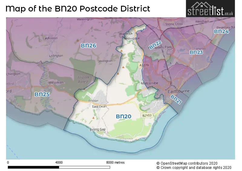
The BN20 Postcode shares a border with BN26 (POLEGATE, Alfriston, Berwick), BN25 (SEAFORD), BN21 (EASTBOURNE) and BN22 (EASTBOURNE).
In the BN20 postcode district in East Sussex, the primary settlement is Eastbourne. Other significant settlements include Beachy Head, East Dean, Friston, Old Town, Ratton, and Willingdon. The most significant post town in this area is Eastbourne in the county of East Sussex, England.
For the district BN20, we have data on 4 postcode sectors. Here's a breakdown: The sector BN20 0, covers East Dean and Friston in East Sussex. The sector BN20 7, covers Eastbourne in East Sussex. The sector BN20 8, covers Eastbourne in East Sussex. The sector BN20 9, covers Eastbourne and Willingdon in East Sussex.

Map of the BN20 Postcode District
Explore the BN20 postcode district by using our free interactive map.
When it comes to local government, postal geography often disregards political borders. However, for a breakdown in the BN20 District: the district mostly encompasses the Eastbourne District (B) (534 postcodes), and finally, the Wealden District area (192 postcodes).
Where is the BN20 Postcode District?
The postcode district BN20 is located in the town of Eastbourne. It is situated near several other towns, including Polegate to the north (4.49 miles away), Seaford to the west (5.52 miles away), Pevensey to the northeast (6.10 miles away), and Lewes to the northwest (12.48 miles away). In addition, Eastbourne is approximately 53.62 miles away from the center of London.
The district is within the post town of EASTBOURNE.
The sector has postcodes within the nation of England.
The BN20 Postcode District is in the East Sussex CC region of Surrey, East and West Sussex within the South East (England).
Weather Forecast for BN20
Press Button to Show Forecast for Eastbourne Youth Hostel
| Time Period | Icon | Description | Temperature | Rain Probability | Wind |
|---|---|---|---|---|---|
| 12:00 to 15:00 | Cloudy | 20.0°C (feels like 18.0°C) | 3.00% | ESE 9 mph | |
| 15:00 to 18:00 | Cloudy | 21.0°C (feels like 20.0°C) | 3.00% | ESE 9 mph | |
| 18:00 to 21:00 | Cloudy | 18.0°C (feels like 17.0°C) | 5.00% | SE 7 mph | |
| 21:00 to 00:00 | Cloudy | 14.0°C (feels like 13.0°C) | 8.00% | SW 7 mph |
Press Button to Show Forecast for Eastbourne Youth Hostel
| Time Period | Icon | Description | Temperature | Rain Probability | Wind |
|---|---|---|---|---|---|
| 00:00 to 03:00 | Partly cloudy (night) | 12.0°C (feels like 10.0°C) | 17.00% | SW 11 mph | |
| 03:00 to 06:00 | Mist | 11.0°C (feels like 9.0°C) | 17.00% | SW 11 mph | |
| 06:00 to 09:00 | Overcast | 12.0°C (feels like 9.0°C) | 18.00% | SW 11 mph | |
| 09:00 to 12:00 | Overcast | 14.0°C (feels like 12.0°C) | 7.00% | SSW 11 mph | |
| 12:00 to 15:00 | Cloudy | 15.0°C (feels like 13.0°C) | 8.00% | S 11 mph | |
| 15:00 to 18:00 | Cloudy | 16.0°C (feels like 15.0°C) | 4.00% | SE 11 mph | |
| 18:00 to 21:00 | Cloudy | 16.0°C (feels like 15.0°C) | 6.00% | ESE 9 mph | |
| 21:00 to 00:00 | Cloudy | 15.0°C (feels like 13.0°C) | 19.00% | ESE 9 mph |
Press Button to Show Forecast for Eastbourne Youth Hostel
| Time Period | Icon | Description | Temperature | Rain Probability | Wind |
|---|---|---|---|---|---|
| 00:00 to 03:00 | Light rain | 14.0°C (feels like 13.0°C) | 52.00% | SSE 9 mph | |
| 03:00 to 06:00 | Light rain | 14.0°C (feels like 12.0°C) | 58.00% | SE 9 mph | |
| 06:00 to 09:00 | Heavy rain | 13.0°C (feels like 12.0°C) | 86.00% | SE 9 mph | |
| 09:00 to 12:00 | Heavy rain | 14.0°C (feels like 12.0°C) | 88.00% | S 9 mph | |
| 12:00 to 15:00 | Heavy rain | 14.0°C (feels like 12.0°C) | 80.00% | SSW 11 mph | |
| 15:00 to 18:00 | Cloudy | 15.0°C (feels like 13.0°C) | 19.00% | S 11 mph | |
| 18:00 to 21:00 | Cloudy | 15.0°C (feels like 13.0°C) | 10.00% | SE 9 mph | |
| 21:00 to 00:00 | Cloudy | 13.0°C (feels like 11.0°C) | 8.00% | SE 9 mph |
Press Button to Show Forecast for Eastbourne Youth Hostel
| Time Period | Icon | Description | Temperature | Rain Probability | Wind |
|---|---|---|---|---|---|
| 00:00 to 03:00 | Cloudy | 12.0°C (feels like 11.0°C) | 7.00% | SSE 9 mph | |
| 03:00 to 06:00 | Clear night | 12.0°C (feels like 10.0°C) | 3.00% | SSE 9 mph | |
| 06:00 to 09:00 | Partly cloudy (day) | 12.0°C (feels like 11.0°C) | 4.00% | SSE 9 mph | |
| 09:00 to 12:00 | Partly cloudy (day) | 14.0°C (feels like 13.0°C) | 7.00% | SSE 11 mph | |
| 12:00 to 15:00 | Sunny day | 16.0°C (feels like 14.0°C) | 6.00% | SSE 11 mph | |
| 15:00 to 18:00 | Sunny day | 16.0°C (feels like 15.0°C) | 4.00% | SSE 9 mph | |
| 18:00 to 21:00 | Sunny day | 16.0°C (feels like 15.0°C) | 3.00% | SE 7 mph | |
| 21:00 to 00:00 | Clear night | 12.0°C (feels like 11.0°C) | 0.00% | ESE 7 mph |
Press Button to Show Forecast for Eastbourne Youth Hostel
| Time Period | Icon | Description | Temperature | Rain Probability | Wind |
|---|---|---|---|---|---|
| 00:00 to 03:00 | Clear night | 11.0°C (feels like 10.0°C) | 1.00% | ESE 7 mph | |
| 03:00 to 06:00 | Clear night | 10.0°C (feels like 8.0°C) | 2.00% | ENE 4 mph | |
| 06:00 to 09:00 | Partly cloudy (day) | 12.0°C (feels like 11.0°C) | 4.00% | ENE 4 mph | |
| 09:00 to 12:00 | Partly cloudy (day) | 16.0°C (feels like 15.0°C) | 7.00% | SE 4 mph | |
| 12:00 to 15:00 | Light rain shower (day) | 16.0°C (feels like 15.0°C) | 34.00% | SSE 7 mph | |
| 15:00 to 18:00 | Sunny day | 17.0°C (feels like 16.0°C) | 12.00% | SSE 7 mph | |
| 18:00 to 21:00 | Cloudy | 16.0°C (feels like 16.0°C) | 11.00% | SW 4 mph | |
| 21:00 to 00:00 | Cloudy | 12.0°C (feels like 12.0°C) | 8.00% | SW 4 mph |
| Postcode Sector | Delivery Office |
|---|---|
| BN20 0 | Eastbourne Delivery Office |
| BN20 7 | Eastbourne Delivery Office |
| BN20 8 | Eastbourne Delivery Office |
| BN20 9 | Eastbourne Delivery Office |
| B | N | 2 | 0 | - | X | X | X |
| B | N | 2 | 0 | Space | Numeric | Letter | Letter |
Current Monthly Rental Prices
| # Bedrooms | Min Price | Max Price | Avg Price |
|---|---|---|---|
| £695 | £695 | £695 | |
| 1 | £700 | £700 | £700 |
| 4 | £1,800 | £1,800 | £1,800 |
| 5 | £3,200 | £3,200 | £3,200 |
Current House Prices
| # Bedrooms | Min Price | Max Price | Avg Price |
|---|---|---|---|
| 3 | £975,000 | £975,000 | £975,000 |
| 4 | £895,950 | £1,900,000 | £1,147,496 |
| 5 | £899,950 | £1,470,000 | £1,090,995 |
| 6 | £1,900,000 | £1,900,000 | £1,900,000 |
Estate Agents who Operate in the BN20 District
| Logo | Name | Brand Name | Address | Contact Number | Total Properties |
|---|---|---|---|---|---|
 | Eastbourne | Rager & Roberts | 36 Cornfield Road, Eastbourne, BN21 4QH | 01323 921799 | 46 |
 | Eastbourne | Emslie & Tarrant | 40 Cornfield Road, Eastbourne, BN21 4QH | 01323 408386 | 39 |
 | Eastbourne | Town Property/Town Flats/Town Rentals | 15 Cornfield Road Eastbourne BN21 4QD | 01320 310211 | 23 |
 | Eastbourne | Leaper Stanbrook | 5 Gildredge Road, Eastbourne, BN21 4RB | 01323 921629 | 21 |
 | Eastbourne | Taylor Engley | 6 Cornfield Road, Eastbourne, Sussex, BN21 4PJ | 01323 921874 | 13 |
Yearly House Price Averages for the BN20 Postcode District
| Type of Property | 2018 Average | 2018 Sales | 2017 Average | 2017 Sales | 2016 Average | 2016 Sales | 2015 Average | 2015 Sales |
|---|---|---|---|---|---|---|---|---|
| Detached | £560,707 | 124 | £513,793 | 134 | £491,630 | 159 | £469,863 | 122 |
| Semi-Detached | £333,490 | 78 | £310,362 | 100 | £317,756 | 97 | £282,178 | 96 |
| Terraced | £319,342 | 63 | £338,447 | 53 | £291,718 | 69 | £288,541 | 60 |
| Flats | £249,608 | 155 | £242,238 | 211 | £233,393 | 190 | £201,248 | 209 |