The BN26 postcode district is a postal district located in the BN Brighton postcode area with a population of 13,160 residents according to the 2021 England and Wales Census.
The area of the BN26 postcode district is 28.42 square miles which is 73.60 square kilometres or 18,187.99 acres.
Currently, the BN26 district has about 518 postcode units spread across 2 geographic postcode sectors.
Given that each sector allows for 400 unique postcode combinations, the district has a capacity of 800 postcodes. With 518 postcodes already in use, this leaves 282 units available.
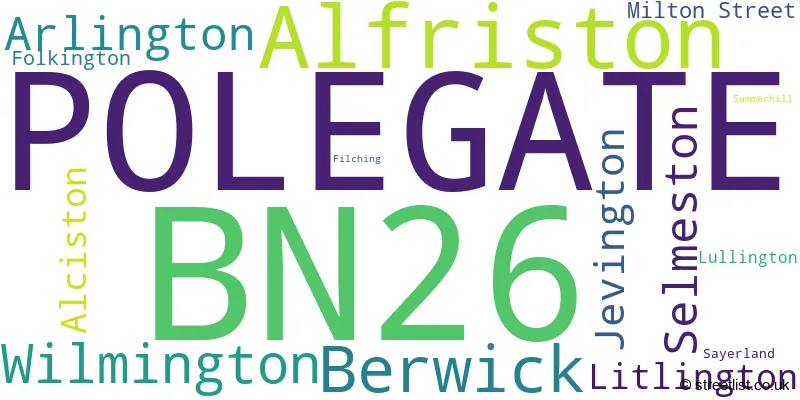
The largest settlement in the BN26 postal code is POLEGATE followed by Alfriston, and Berwick.
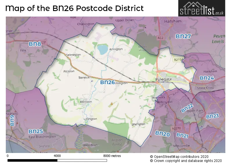
The BN26 Postcode shares a border with BN8 (Ringmer, Newick, South Chailey), BN25 (SEAFORD), BN20 (EASTBOURNE, East Dean, Willingdon), BN24 (Stone Cross, Pevensey Bay, Westham) and BN27 (HAILSHAM, Hellingly, Herstmonceux).
The primary settlement in the BN26 postcode district is Polegate, which is located in the county of East Sussex in England. The other significant settlements in the district include Alfriston, Berwick, Filching, Folkington, Jevington, Litlington, Lullington, Milton Street, Sayerland, Selmeston, Summerhill, and Wilmington. The main post town for the district is also Polegate.
For the district BN26, we have data on 3 postcode sectors. Here's a breakdown: The sector BN26 5, covers Polegate and Alfriston in East Sussex. The sector BN26 6, covers Polegate in East Sussex. The sector BN26 9 is non-geographic. It's often designated for PO Boxes, large organisations, or special services.

Map of the BN26 Postcode District
Explore the BN26 postcode district by using our free interactive map.
When it comes to local government, postal geography often disregards political borders. However, for a breakdown in the BN26 District: the district mostly encompasses the Wealden District area with a total of 523 postcodes.
Weather Forecast for BN26
Press Button to Show Forecast for Litlington
| Time Period | Icon | Description | Temperature | Rain Probability | Wind |
|---|---|---|---|---|---|
| 09:00 to 12:00 | Cloudy | 11.0°C (feels like 10.0°C) | 32.00% | E 7 mph | |
| 12:00 to 15:00 | Cloudy | 13.0°C (feels like 12.0°C) | 8.00% | SE 7 mph | |
| 15:00 to 18:00 | Cloudy | 13.0°C (feels like 12.0°C) | 17.00% | E 7 mph | |
| 18:00 to 21:00 | Heavy rain | 11.0°C (feels like 9.0°C) | 86.00% | ENE 9 mph | |
| 21:00 to 00:00 | Heavy rain | 10.0°C (feels like 8.0°C) | 90.00% | NE 9 mph |
Press Button to Show Forecast for Litlington
| Time Period | Icon | Description | Temperature | Rain Probability | Wind |
|---|---|---|---|---|---|
| 00:00 to 03:00 | Heavy rain | 10.0°C (feels like 9.0°C) | 87.00% | NE 9 mph | |
| 03:00 to 06:00 | Heavy rain | 10.0°C (feels like 8.0°C) | 87.00% | SE 11 mph | |
| 06:00 to 09:00 | Light rain | 10.0°C (feels like 8.0°C) | 52.00% | SSW 11 mph | |
| 09:00 to 12:00 | Light rain shower (day) | 11.0°C (feels like 8.0°C) | 44.00% | WSW 16 mph | |
| 12:00 to 15:00 | Light rain shower (day) | 11.0°C (feels like 8.0°C) | 39.00% | WSW 16 mph | |
| 15:00 to 18:00 | Light rain shower (day) | 11.0°C (feels like 9.0°C) | 33.00% | W 13 mph | |
| 18:00 to 21:00 | Partly cloudy (day) | 11.0°C (feels like 8.0°C) | 5.00% | WSW 11 mph | |
| 21:00 to 00:00 | Clear night | 9.0°C (feels like 7.0°C) | 3.00% | SW 9 mph |
Press Button to Show Forecast for Litlington
| Time Period | Icon | Description | Temperature | Rain Probability | Wind |
|---|---|---|---|---|---|
| 00:00 to 03:00 | Clear night | 8.0°C (feels like 6.0°C) | 2.00% | SW 7 mph | |
| 03:00 to 06:00 | Clear night | 7.0°C (feels like 5.0°C) | 2.00% | SSW 7 mph | |
| 06:00 to 09:00 | Sunny day | 9.0°C (feels like 7.0°C) | 1.00% | S 7 mph | |
| 09:00 to 12:00 | Partly cloudy (day) | 12.0°C (feels like 10.0°C) | 2.00% | S 9 mph | |
| 12:00 to 15:00 | Partly cloudy (day) | 13.0°C (feels like 11.0°C) | 1.00% | S 11 mph | |
| 15:00 to 18:00 | Sunny day | 14.0°C (feels like 12.0°C) | 2.00% | S 9 mph | |
| 18:00 to 21:00 | Sunny day | 13.0°C (feels like 12.0°C) | 1.00% | SSE 7 mph | |
| 21:00 to 00:00 | Partly cloudy (night) | 10.0°C (feels like 8.0°C) | 3.00% | ESE 7 mph |
Press Button to Show Forecast for Litlington
| Time Period | Icon | Description | Temperature | Rain Probability | Wind |
|---|---|---|---|---|---|
| 00:00 to 03:00 | Partly cloudy (night) | 9.0°C (feels like 8.0°C) | 3.00% | ESE 7 mph | |
| 03:00 to 06:00 | Clear night | 9.0°C (feels like 7.0°C) | 3.00% | ESE 7 mph | |
| 06:00 to 09:00 | Sunny day | 10.0°C (feels like 9.0°C) | 5.00% | ESE 7 mph | |
| 09:00 to 12:00 | Cloudy | 13.0°C (feels like 12.0°C) | 8.00% | SE 9 mph | |
| 12:00 to 15:00 | Cloudy | 14.0°C (feels like 12.0°C) | 12.00% | SE 11 mph | |
| 15:00 to 18:00 | Cloudy | 15.0°C (feels like 14.0°C) | 9.00% | SE 9 mph | |
| 18:00 to 21:00 | Cloudy | 14.0°C (feels like 13.0°C) | 10.00% | ESE 9 mph | |
| 21:00 to 00:00 | Overcast | 12.0°C (feels like 11.0°C) | 13.00% | ESE 7 mph |
Where is the BN26 Postcode District?
The BN26 postcode district is located in the town of Polegate. It is situated near several other towns, including Hailsham to the North East (approximately 3.98 miles away), Seaford to the South West (approximately 4.30 miles away), Eastbourne to the South East (approximately 4.80 miles away), Newhaven to the West (approximately 6.08 miles away), Pevensey to the East (approximately 6.79 miles away), Lewes to the North West (approximately 8.67 miles away), and Heathfield to the North (approximately 10.04 miles away). The postcode district is also approximately 49.31 miles away from the center of London.
The district is within the post town of POLEGATE.
The sector has postcodes within the nation of England.
The BN26 Postcode District is in the East Sussex CC region of Surrey, East and West Sussex within the South East (England).
| Postcode Sector | Delivery Office |
|---|---|
| BN26 5 | Polegate Delivery Office |
| BN26 6 | Polegate Delivery Office |
| B | N | 2 | 6 | - | X | X | X |
| B | N | 2 | 6 | Space | Numeric | Letter | Letter |
Tourist Attractions within the Postcode Area
We found 1 visitor attractions within the BN26 postcode area
| Alfriston Clergy House |
|---|
| Historic Properties |
| Historic House / House and Garden / Palace |
| View Alfriston Clergy House on Google Maps |
Current Monthly Rental Prices
| # Bedrooms | Min Price | Max Price | Avg Price |
|---|---|---|---|
| £1,000 | £1,000 | £1,000 | |
| 1 | £925 | £925 | £925 |
| 2 | £950 | £1,150 | £1,050 |
| 3 | £1,550 | £1,550 | £1,550 |
| 5 | £4,000 | £4,000 | £4,000 |
Current House Prices
| # Bedrooms | Min Price | Max Price | Avg Price |
|---|---|---|---|
| £750,000 | £750,000 | £750,000 | |
| 2 | £600,000 | £825,000 | £712,500 |
| 3 | £599,950 | £1,200,000 | £804,158 |
| 4 | £750,000 | £1,295,000 | £1,101,667 |
| 5 | £595,000 | £1,350,000 | £1,074,000 |
| 6 | £2,950,000 | £2,950,000 | £2,950,000 |
| 7 | £1,850,000 | £1,850,000 | £1,850,000 |
Estate Agents who Operate in the BN26 District
| Logo | Name | Brand Name | Address | Contact Number | Total Properties |
|---|---|---|---|---|---|
 | Eastbourne | Move Sussex | Eastbourne | 01323 401851 | 17 |
 | Polegate | Your Move | 91 High Street Polegate BN26 6AE | 01323 396969 | 15 |
 | Polegate | Archer & Partners | 48 High Street, Polegate, BN26 6AG | 01323 921847 | 14 |
 | Polegate | Fox & Sons | 56a High Street, Polegate, East Sussex, BN26 6AD | 01323 403301 | 12 |
 | Eastbourne | Rager & Roberts | 36 Cornfield Road, Eastbourne, BN21 4QH | 01323 921799 | 10 |
| Type of Property | 2018 Average | 2018 Sales | 2017 Average | 2017 Sales | 2016 Average | 2016 Sales | 2015 Average | 2015 Sales |
|---|---|---|---|---|---|---|---|---|
| Detached | £467,831 | 76 | £439,059 | 68 | £426,435 | 110 | £377,007 | 102 |
| Semi-Detached | £276,945 | 121 | £260,581 | 134 | £253,634 | 105 | £241,236 | 142 |
| Terraced | £280,706 | 45 | £239,588 | 39 | £254,462 | 59 | £226,355 | 54 |
| Flats | £155,969 | 35 | £142,672 | 37 | £141,631 | 42 | £135,427 | 59 |