The BN8 postcode district is a postal district located in the BN Brighton postcode area with a population of 16,084 residents according to the 2021 England and Wales Census.
The area of the BN8 postcode district is 69.25 square miles which is 179.36 square kilometres or 44,321.28 acres.
Currently, the BN8 district has about 667 postcode units spread across 3 geographic postcode sectors.
Given that each sector allows for 400 unique postcode combinations, the district has a capacity of 1,200 postcodes. With 667 postcodes already in use, this leaves 533 units available.
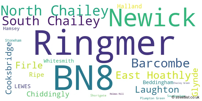
The largest settlement in the BN8 postal code is Ringmer followed by Newick, and South Chailey.
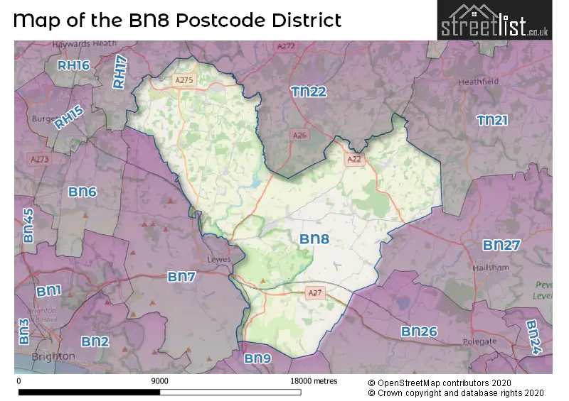
The BN8 Postcode shares a border with TN22 (UCKFIELD, Ridgewood, Buxted), BN26 (POLEGATE, Alfriston, Berwick), BN9 (NEWHAVEN, South Heighton, Piddinghoe), BN25 (SEAFORD), BN27 (HAILSHAM, Hellingly, Herstmonceux), TN21 (HEATHFIELD, Horam, Cross In Hand), RH17 (Cuckfield, Balcombe, Ardingly) and BN7 (LEWES, Plumpton Green, Kingston).
The primary settlement in the BN8 postcode district is Lewes, located in the county of East Sussex in England. Other significant settlements in this postcode district include Chailey Green, Cooksbridge, Newick, North Chailey, Plumpton Green, South Chailey, Barcombe, Hamsey, Ringmer, Beddingham, Chiddingly, East Hoathly, Firle, Glynde, Halland, Laughton, Ripe, Shortgate, Southerham, and Whitesmith. The most significant postal town with the highest number of postcodes is Lewes.
For the district BN8, we have data on 3 postcode sectors. Here's a breakdown: The sector BN8 4, covers Newick and South Chailey and North Chailey and Cooksbridge in East Sussex. The sector BN8 5, covers Ringmer and Barcombe in East Sussex. The sector BN8 6, covers East Hoathly and Firle and Laughton and Glynde in East Sussex.

Map of the BN8 Postcode District
Explore the BN8 postcode district by using our free interactive map.
When it comes to local government, postal geography often disregards political borders. However, for a breakdown in the BN8 District: the district mostly encompasses the Lewes District (557 postcodes), and finally, the Wealden District area (124 postcodes).
Weather Forecast for BN8
Press Button to Show Forecast for Lewes
| Time Period | Icon | Description | Temperature | Rain Probability | Wind |
|---|---|---|---|---|---|
| 09:00 to 12:00 | Cloudy | 11.0°C (feels like 9.0°C) | 42.00% | ENE 7 mph | |
| 12:00 to 15:00 | Cloudy | 13.0°C (feels like 11.0°C) | 34.00% | SE 7 mph | |
| 15:00 to 18:00 | Overcast | 13.0°C (feels like 12.0°C) | 19.00% | E 7 mph | |
| 18:00 to 21:00 | Light rain | 11.0°C (feels like 10.0°C) | 65.00% | NE 7 mph | |
| 21:00 to 00:00 | Heavy rain | 10.0°C (feels like 8.0°C) | 89.00% | NE 9 mph |
Press Button to Show Forecast for Lewes
| Time Period | Icon | Description | Temperature | Rain Probability | Wind |
|---|---|---|---|---|---|
| 00:00 to 03:00 | Heavy rain | 10.0°C (feels like 8.0°C) | 89.00% | NE 9 mph | |
| 03:00 to 06:00 | Heavy rain shower (night) | 10.0°C (feels like 8.0°C) | 73.00% | ESE 7 mph | |
| 06:00 to 09:00 | Heavy rain shower (day) | 10.0°C (feels like 7.0°C) | 62.00% | WSW 11 mph | |
| 09:00 to 12:00 | Light rain shower (day) | 10.0°C (feels like 7.0°C) | 45.00% | SSW 13 mph | |
| 12:00 to 15:00 | Light rain | 10.0°C (feels like 7.0°C) | 52.00% | W 13 mph | |
| 15:00 to 18:00 | Cloudy | 11.0°C (feels like 8.0°C) | 15.00% | W 13 mph | |
| 18:00 to 21:00 | Cloudy | 10.0°C (feels like 8.0°C) | 9.00% | WSW 9 mph | |
| 21:00 to 00:00 | Clear night | 8.0°C (feels like 6.0°C) | 2.00% | SW 7 mph |
Press Button to Show Forecast for Lewes
| Time Period | Icon | Description | Temperature | Rain Probability | Wind |
|---|---|---|---|---|---|
| 00:00 to 03:00 | Clear night | 6.0°C (feels like 5.0°C) | 1.00% | SW 7 mph | |
| 03:00 to 06:00 | Clear night | 6.0°C (feels like 4.0°C) | 1.00% | SW 7 mph | |
| 06:00 to 09:00 | Sunny day | 8.0°C (feels like 7.0°C) | 1.00% | S 4 mph | |
| 09:00 to 12:00 | Partly cloudy (day) | 12.0°C (feels like 10.0°C) | 4.00% | S 9 mph | |
| 12:00 to 15:00 | Cloudy | 13.0°C (feels like 11.0°C) | 5.00% | S 11 mph | |
| 15:00 to 18:00 | Sunny day | 13.0°C (feels like 12.0°C) | 3.00% | S 9 mph | |
| 18:00 to 21:00 | Sunny day | 12.0°C (feels like 11.0°C) | 2.00% | SSE 7 mph | |
| 21:00 to 00:00 | Clear night | 8.0°C (feels like 7.0°C) | 2.00% | ESE 7 mph |
Press Button to Show Forecast for Lewes
| Time Period | Icon | Description | Temperature | Rain Probability | Wind |
|---|---|---|---|---|---|
| 00:00 to 03:00 | Clear night | 9.0°C (feels like 7.0°C) | 3.00% | ESE 9 mph | |
| 03:00 to 06:00 | Clear night | 8.0°C (feels like 6.0°C) | 3.00% | ESE 7 mph | |
| 06:00 to 09:00 | Partly cloudy (day) | 10.0°C (feels like 8.0°C) | 6.00% | ESE 9 mph | |
| 09:00 to 12:00 | Partly cloudy (day) | 14.0°C (feels like 12.0°C) | 5.00% | SE 9 mph | |
| 12:00 to 15:00 | Cloudy | 15.0°C (feels like 13.0°C) | 11.00% | SE 11 mph | |
| 15:00 to 18:00 | Cloudy | 16.0°C (feels like 14.0°C) | 13.00% | SE 9 mph | |
| 18:00 to 21:00 | Cloudy | 14.0°C (feels like 13.0°C) | 10.00% | ESE 9 mph | |
| 21:00 to 00:00 | Overcast | 11.0°C (feels like 10.0°C) | 13.00% | ESE 7 mph |
Where is the BN8 Postcode District?
The postcode district BN8 is located in the town of Lewes. Lewes is in close proximity to several nearby towns. To the north of Lewes is Uckfield, which is approximately 5.07 miles away. Hailsham is situated to the east, about 7.54 miles away. Newhaven is to the south, with a distance of 7.74 miles. Heathfield is situated to the northeast, roughly 8.99 miles away. Polegate is located to the southeast, approximately 9.13 miles away. Burgess Hill is to the west, around 9.44 miles away. Brighton is situated to the southwest and is approximately 9.57 miles away. Additionally, the postcode district BN8 is about 42.46 miles away from the center of London.
The district is within the post town of LEWES.
The sector has postcodes within the nation of England.
The BN8 Postcode District is covers the following regions.
- East Sussex CC - Surrey, East and West Sussex - South East (England)
- West Sussex (North East) - Surrey, East and West Sussex - South East (England)
| Postcode Sector | Delivery Office |
|---|---|
| BN8 4 | Lewes Delivery Office |
| BN8 5 | Lewes Delivery Office |
| BN8 6 | Lewes Delivery Office |
| B | N | 8 | - | X | X | X |
| B | N | 8 | Space | Numeric | Letter | Letter |
Current Monthly Rental Prices
| # Bedrooms | Min Price | Max Price | Avg Price |
|---|---|---|---|
| 1 | £875 | £875 | £875 |
| 2 | £1,225 | £1,225 | £1,225 |
| 3 | £1,350 | £1,600 | £1,463 |
| 4 | £3,300 | £3,500 | £3,400 |
| 5 | £3,000 | £3,000 | £3,000 |
Current House Prices
| # Bedrooms | Min Price | Max Price | Avg Price |
|---|---|---|---|
| 4 | £1,125,000 | £2,200,000 | £1,618,750 |
| 5 | £1,100,000 | £4,250,000 | £1,876,818 |
| 6 | £1,650,000 | £2,500,000 | £2,075,000 |
| 7 | £1,750,000 | £2,000,000 | £1,916,667 |
| 8 | £1,750,000 | £1,750,000 | £1,750,000 |
Estate Agents who Operate in the BN8 District
| Logo | Name | Brand Name | Address | Contact Number | Total Properties |
|---|---|---|---|---|---|
 | Ringmer | Freeman Forman | The Green Lewes Road Ringmer Lewes BN8 5QE | 01273 109710 | 24 |
 | Newick | Mansell McTaggart | The Green, Newick, BN8 4LA | 01825 705524 | 14 |
 | Haywards Heath | Savills | 4 Chelsea Arcade The Broadway Haywards Heath RH16 3AP | 01444 718182 | 13 |
 | Lewes | Fox & Sons | 192 High Street, Lewes, East Sussex, BN7 2NS | 01273 109770 | 13 |
 | Lewes | Rowland Gorringe | 64 High Street Lewes BN7 1XG | 01273 109888 | 10 |
- Ashton Green
- Barcombe Cross
- Barcombe
- Barcombe Mills
- Beddingham
- Broyle Side
- Chalvington
- Chiddingly
- Chiltington
- Cooksbridge
- Cornwell's Bank
- East Hoathly
- Firle
- Fletching Common
- Glynde
- Glyndebourne
- Golden Cross
- Gun Hill
- Halland
- Isfield
- Laughton
- Lewes
- Mount Pleasant
- Muddles Green
- Newick
- Norlington
- North Chailey
- Offham
- Plumpton Green
- Ringmer
- Ripe
- Rodmell
- Rose Hill
- Selmeston
- Shortgate
- South Chailey
- South Street
- Upper Wellingham
- Whitesmith
- Wivelsfield Green
| Type of Property | 2018 Average | 2018 Sales | 2017 Average | 2017 Sales | 2016 Average | 2016 Sales | 2015 Average | 2015 Sales |
|---|---|---|---|---|---|---|---|---|
| Detached | £677,036 | 98 | £573,450 | 86 | £570,938 | 93 | £595,381 | 102 |
| Semi-Detached | £386,539 | 59 | £367,788 | 70 | £349,013 | 65 | £347,971 | 52 |
| Terraced | £308,986 | 35 | £301,700 | 42 | £286,971 | 44 | £278,318 | 43 |
| Flats | £308,638 | 13 | £202,927 | 11 | £183,571 | 21 | £211,661 | 14 |