The BN7 postcode district is a postal district located in the BN Brighton postcode area with a population of 20,330 residents according to the 2021 England and Wales Census.
The area of the BN7 postcode district is 28.53 square miles which is 73.90 square kilometres or 18,260.17 acres.
Currently, the BN7 district has about 754 postcode units spread across 3 geographic postcode sectors.
Given that each sector allows for 400 unique postcode combinations, the district has a capacity of 1,200 postcodes. With 754 postcodes already in use, this leaves 446 units available.
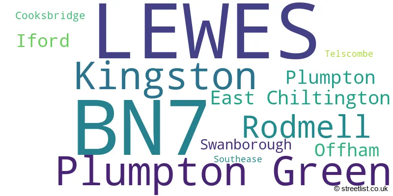
The largest settlement in the BN7 postal code is LEWES followed by Plumpton Green, and Kingston.
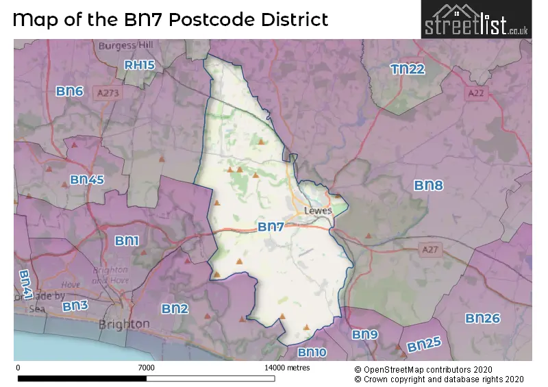
The BN7 Postcode shares a border with BN8 (Ringmer, Newick, South Chailey), BN2 (BRIGHTON, Saltdean, Rottingdean), BN10 (PEACEHAVEN, Telscombe Cliffs), BN9 (NEWHAVEN, South Heighton, Piddinghoe), RH17 (Cuckfield, Balcombe, Ardingly) and BN6 (HASSOCKS, Hurstpierpoint, Ditchling).
In the BN7 postcode district, the primary settlement is Lewes, which is located in the county of East Sussex in England. Lewes has the highest count in this district. Other significant settlements in BN7 include Cooksbridge, East Chiltington, Iford, Kingston, Offham, Plumpton, Plumpton Green, Rodmell, Southease, Swanborough, and Telscombe. The most significant post town in BN7 is also Lewes.
For the district BN7, we have data on 4 postcode sectors. Here's a breakdown: The sector BN7 1, covers Lewes in East Sussex. The sector BN7 2, covers Lewes in East Sussex. The sector BN7 3, covers Plumpton Green and Kingston and Rodmell in East Sussex. The sector BN7 9 is non-geographic. It's often designated for PO Boxes, large organisations, or special services.

Map of the BN7 Postcode District
Explore the BN7 postcode district by using our free interactive map.
When it comes to local government, postal geography often disregards political borders. However, for a breakdown in the BN7 District: the district mostly encompasses the Lewes District area with a total of 756 postcodes.
Weather Forecast for BN7
Press Button to Show Forecast for Lewes
| Time Period | Icon | Description | Temperature | Rain Probability | Wind |
|---|---|---|---|---|---|
| 06:00 to 09:00 | Overcast | 7.0°C (feels like 6.0°C) | 16.00% | NE 7 mph | |
| 09:00 to 12:00 | Cloudy | 11.0°C (feels like 9.0°C) | 42.00% | ENE 7 mph | |
| 12:00 to 15:00 | Cloudy | 13.0°C (feels like 11.0°C) | 34.00% | SE 7 mph | |
| 15:00 to 18:00 | Overcast | 13.0°C (feels like 12.0°C) | 19.00% | E 7 mph | |
| 18:00 to 21:00 | Light rain | 11.0°C (feels like 10.0°C) | 65.00% | NE 7 mph | |
| 21:00 to 00:00 | Heavy rain | 10.0°C (feels like 8.0°C) | 89.00% | NE 9 mph |
Press Button to Show Forecast for Lewes
| Time Period | Icon | Description | Temperature | Rain Probability | Wind |
|---|---|---|---|---|---|
| 00:00 to 03:00 | Heavy rain | 10.0°C (feels like 8.0°C) | 89.00% | NE 9 mph | |
| 03:00 to 06:00 | Heavy rain shower (night) | 10.0°C (feels like 8.0°C) | 73.00% | ESE 7 mph | |
| 06:00 to 09:00 | Heavy rain shower (day) | 10.0°C (feels like 7.0°C) | 62.00% | WSW 11 mph | |
| 09:00 to 12:00 | Light rain shower (day) | 10.0°C (feels like 7.0°C) | 45.00% | SSW 13 mph | |
| 12:00 to 15:00 | Light rain | 10.0°C (feels like 7.0°C) | 52.00% | W 13 mph | |
| 15:00 to 18:00 | Cloudy | 11.0°C (feels like 8.0°C) | 15.00% | W 13 mph | |
| 18:00 to 21:00 | Cloudy | 10.0°C (feels like 8.0°C) | 9.00% | WSW 9 mph | |
| 21:00 to 00:00 | Clear night | 8.0°C (feels like 6.0°C) | 2.00% | SW 7 mph |
Press Button to Show Forecast for Lewes
| Time Period | Icon | Description | Temperature | Rain Probability | Wind |
|---|---|---|---|---|---|
| 00:00 to 03:00 | Clear night | 6.0°C (feels like 5.0°C) | 1.00% | SW 7 mph | |
| 03:00 to 06:00 | Clear night | 6.0°C (feels like 4.0°C) | 1.00% | SW 7 mph | |
| 06:00 to 09:00 | Sunny day | 8.0°C (feels like 7.0°C) | 1.00% | S 4 mph | |
| 09:00 to 12:00 | Partly cloudy (day) | 12.0°C (feels like 10.0°C) | 4.00% | S 9 mph | |
| 12:00 to 15:00 | Cloudy | 13.0°C (feels like 11.0°C) | 5.00% | S 11 mph | |
| 15:00 to 18:00 | Sunny day | 13.0°C (feels like 12.0°C) | 3.00% | S 9 mph | |
| 18:00 to 21:00 | Sunny day | 12.0°C (feels like 11.0°C) | 2.00% | SSE 7 mph | |
| 21:00 to 00:00 | Clear night | 8.0°C (feels like 7.0°C) | 2.00% | ESE 7 mph |
Press Button to Show Forecast for Lewes
| Time Period | Icon | Description | Temperature | Rain Probability | Wind |
|---|---|---|---|---|---|
| 00:00 to 03:00 | Clear night | 9.0°C (feels like 7.0°C) | 3.00% | ESE 9 mph | |
| 03:00 to 06:00 | Clear night | 8.0°C (feels like 6.0°C) | 3.00% | ESE 7 mph | |
| 06:00 to 09:00 | Partly cloudy (day) | 10.0°C (feels like 8.0°C) | 6.00% | ESE 9 mph | |
| 09:00 to 12:00 | Partly cloudy (day) | 14.0°C (feels like 12.0°C) | 5.00% | SE 9 mph | |
| 12:00 to 15:00 | Cloudy | 15.0°C (feels like 13.0°C) | 11.00% | SE 11 mph | |
| 15:00 to 18:00 | Cloudy | 16.0°C (feels like 14.0°C) | 13.00% | SE 9 mph | |
| 18:00 to 21:00 | Cloudy | 14.0°C (feels like 13.0°C) | 10.00% | ESE 9 mph | |
| 21:00 to 00:00 | Overcast | 11.0°C (feels like 10.0°C) | 13.00% | ESE 7 mph |
Where is the BN7 Postcode District?
The postcode district BN7 is located in the town of Lewes in East Sussex. Lewes is a district town and is surrounded by several nearby towns. To the west, there is Brighton, which is approximately 4.75 miles away. To the south, there is Peacehaven, located around 5.49 miles from Lewes. In the southeast, there is Newhaven, situated approximately 6.44 miles away. In the northwest, there is Hassocks, around 6.64 miles from Lewes. Further northeast, there is Uckfield, which is approximately 9.15 miles away. Finally, to the north, there is Haywards Heath, located around 9.41 miles from Lewes. Additionally, Lewes is approximately 44.04 miles away from the center of London.
The district is within the post town of LEWES.
The sector has postcodes within the nation of England.
The BN7 Postcode District is in the East Sussex CC region of Surrey, East and West Sussex within the South East (England).
| Postcode Sector | Delivery Office |
|---|---|
| BN7 1 | Lewes Delivery Office |
| BN7 2 | Lewes Delivery Office |
| BN7 3 | Lewes Delivery Office |
| BN7 9 | Lewes Delivery Office |
| B | N | 7 | - | X | X | X |
| B | N | 7 | Space | Numeric | Letter | Letter |
Tourist Attractions within the Postcode Area
We found 1 visitor attractions within the BN7 postcode area
| Monk's House |
|---|
| Historic Properties |
| Historic House / House and Garden / Palace |
| View Monk's House on Google Maps |
Current Monthly Rental Prices
| # Bedrooms | Min Price | Max Price | Avg Price |
|---|---|---|---|
| £575 | £575 | £575 | |
| 1 | £920 | £1,200 | £1,008 |
| 2 | £1,350 | £1,600 | £1,449 |
| 3 | £1,995 | £1,995 | £1,995 |
| 4 | £1,700 | £6,000 | £3,533 |
Current House Prices
| # Bedrooms | Min Price | Max Price | Avg Price |
|---|---|---|---|
| £1,500,000 | £1,500,000 | £1,500,000 | |
| 2 | £1,200,000 | £1,200,000 | £1,200,000 |
| 3 | £1,225,000 | £1,225,000 | £1,225,000 |
| 4 | £1,250,000 | £2,500,000 | £1,545,833 |
| 5 | £1,200,000 | £2,450,000 | £1,714,000 |
| 6 | £1,300,000 | £2,750,000 | £2,169,000 |
| 7 | £1,250,000 | £1,250,000 | £1,250,000 |
Estate Agents who Operate in the BN7 District
| Logo | Name | Brand Name | Address | Contact Number | Total Properties |
|---|---|---|---|---|---|
 | Lewes | Mansell McTaggart | Albion House Albion Street, Lewes, BN7 2NF | 01277 674466 | 53 |
 | Lewes | Charles Wycherley Independent Estate Agents | 56 High Street, Lewes, East Sussex, BN7 1XE | 01273 109740 | 43 |
 | Lewes | Oakley Property | 14A High Street, Lewes, BN7 2LN | 01273 109772 | 29 |
 | Lewes | Fox & Sons | 192 High Street, Lewes, East Sussex, BN7 2NS | 01273 109770 | 27 |
 | Lewes | Cubitt & West | 78-79 High Street, Lewes, East Sussex, BN7 1XN | 01273 109733 | 20 |
| Type of Property | 2018 Average | 2018 Sales | 2017 Average | 2017 Sales | 2016 Average | 2016 Sales | 2015 Average | 2015 Sales |
|---|---|---|---|---|---|---|---|---|
| Detached | £733,953 | 44 | £811,144 | 52 | £801,954 | 56 | £618,136 | 54 |
| Semi-Detached | £435,356 | 77 | £438,187 | 69 | £496,306 | 65 | £447,423 | 73 |
| Terraced | £457,127 | 90 | £475,604 | 98 | £456,318 | 122 | £379,307 | 129 |
| Flats | £258,254 | 65 | £261,537 | 68 | £261,534 | 76 | £247,649 | 76 |