The BN41 1 postcode sector stands on the East Sussex and West Sussex border.
Did you know? According to the 2021 Census, the BN41 1 postcode sector is home to a bustling 6,888 residents!
Given that each sector allows for 400 unique postcode combinations. Letters C, I, K, M, O and V are not allowed in the last two letters of a postcode. With 153 postcodes already in use, this leaves 247 units available.
The BN41 1 postal code covers the settlement of Portslade.
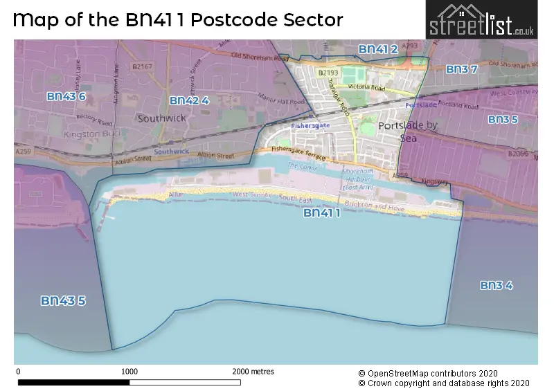
The BN41 1 Postcode shares a border with BN3 5 (HOVE), BN3 7 (HOVE), BN41 2 (Portslade), BN42 4 (Southwick) and BN3 4 (HOVE).
The sector is within the post town of BRIGHTON.
BN41 1 is a postcode sector within the BN41 postcode district which is within the BN Brighton postcode area.
The Royal Mail delivery office for the BN41 1 postal sector is the Portslade Delivery Office.
The area of the BN41 1 postcode sector is 0.74 square miles which is 1.93 square kilometres or 475.73 square acres.

Map of the BN41 1 Postcode Sector
Explore the BN41 1 postcode sector by using our free interactive map.
| B | N | 4 | 1 | - | 1 | X | X |
| B | N | 4 | 1 | Space | 1 | Letter | Letter |
Official List of Streets
Portslade (79 Streets)
Unofficial Streets or Alternative Spellings
HOVE
HALLYBURTON ROAD HANGLETON ROAD KINGSWAY NEW CHURCH ROAD PORTLAND ROAD SEAFORD ROADPortslade
APPLESHAM WAY BENFIELD WAY FOREDOWN DRIVE GEORGE WILLIAMS MEWS LOCKS CRESCENT LOCKS HILL ROMANY CLOSE WINDLESHAM CLOSESouthwick
ALBION STREET MANOR HALL ROAD THE GARDENS WESTBROOK WAYWeather Forecast for BN41 1
Press Button to Show Forecast for Southwick (Beach)
| Time Period | Icon | Description | Temperature | Rain Probability | Wind |
|---|---|---|---|---|---|
| 09:00 to 12:00 | Heavy rain | 7.0°C (feels like 4.0°C) | 75.00% | NE 7 mph | |
| 12:00 to 15:00 | Overcast | 8.0°C (feels like 6.0°C) | 15.00% | ENE 9 mph | |
| 15:00 to 18:00 | Overcast | 9.0°C (feels like 7.0°C) | 12.00% | E 11 mph | |
| 18:00 to 21:00 | Overcast | 9.0°C (feels like 6.0°C) | 14.00% | E 11 mph | |
| 21:00 to 00:00 | Heavy rain | 8.0°C (feels like 5.0°C) | 80.00% | E 9 mph |
Press Button to Show Forecast for Southwick (Beach)
| Time Period | Icon | Description | Temperature | Rain Probability | Wind |
|---|---|---|---|---|---|
| 00:00 to 03:00 | Heavy rain | 8.0°C (feels like 5.0°C) | 80.00% | ENE 11 mph | |
| 03:00 to 06:00 | Light rain | 7.0°C (feels like 5.0°C) | 50.00% | ENE 11 mph | |
| 06:00 to 09:00 | Cloudy | 8.0°C (feels like 5.0°C) | 12.00% | NE 9 mph | |
| 09:00 to 12:00 | Cloudy | 10.0°C (feels like 9.0°C) | 6.00% | E 9 mph | |
| 12:00 to 15:00 | Cloudy | 13.0°C (feels like 11.0°C) | 7.00% | ESE 9 mph | |
| 15:00 to 18:00 | Overcast | 13.0°C (feels like 12.0°C) | 17.00% | ESE 7 mph | |
| 18:00 to 21:00 | Heavy rain | 12.0°C (feels like 10.0°C) | 83.00% | NE 9 mph | |
| 21:00 to 00:00 | Heavy rain | 10.0°C (feels like 8.0°C) | 89.00% | NE 11 mph |
Press Button to Show Forecast for Southwick (Beach)
| Time Period | Icon | Description | Temperature | Rain Probability | Wind |
|---|---|---|---|---|---|
| 00:00 to 03:00 | Light rain | 10.0°C (feels like 8.0°C) | 58.00% | NE 11 mph | |
| 03:00 to 06:00 | Heavy rain shower (night) | 10.0°C (feels like 7.0°C) | 74.00% | E 11 mph | |
| 06:00 to 09:00 | Heavy rain | 10.0°C (feels like 7.0°C) | 84.00% | S 11 mph | |
| 09:00 to 12:00 | Heavy rain | 10.0°C (feels like 7.0°C) | 76.00% | WSW 13 mph | |
| 12:00 to 15:00 | Overcast | 10.0°C (feels like 7.0°C) | 26.00% | W 16 mph | |
| 15:00 to 18:00 | Overcast | 11.0°C (feels like 8.0°C) | 18.00% | W 13 mph | |
| 18:00 to 21:00 | Cloudy | 11.0°C (feels like 8.0°C) | 10.00% | WSW 11 mph | |
| 21:00 to 00:00 | Partly cloudy (night) | 9.0°C (feels like 7.0°C) | 2.00% | SW 9 mph |
Press Button to Show Forecast for Southwick (Beach)
| Time Period | Icon | Description | Temperature | Rain Probability | Wind |
|---|---|---|---|---|---|
| 00:00 to 03:00 | Clear night | 8.0°C (feels like 6.0°C) | 2.00% | SW 9 mph | |
| 03:00 to 06:00 | Clear night | 7.0°C (feels like 5.0°C) | 1.00% | SW 7 mph | |
| 06:00 to 09:00 | Sunny day | 9.0°C (feels like 7.0°C) | 1.00% | S 7 mph | |
| 09:00 to 12:00 | Partly cloudy (day) | 12.0°C (feels like 10.0°C) | 1.00% | S 11 mph | |
| 12:00 to 15:00 | Partly cloudy (day) | 13.0°C (feels like 11.0°C) | 2.00% | S 11 mph | |
| 15:00 to 18:00 | Partly cloudy (day) | 13.0°C (feels like 11.0°C) | 3.00% | S 9 mph | |
| 18:00 to 21:00 | Sunny day | 13.0°C (feels like 11.0°C) | 1.00% | SE 7 mph | |
| 21:00 to 00:00 | Clear night | 10.0°C (feels like 8.0°C) | 2.00% | ESE 9 mph |
Press Button to Show Forecast for Southwick (Beach)
| Time Period | Icon | Description | Temperature | Rain Probability | Wind |
|---|---|---|---|---|---|
| 00:00 to 03:00 | Clear night | 10.0°C (feels like 8.0°C) | 2.00% | ESE 9 mph | |
| 03:00 to 06:00 | Clear night | 9.0°C (feels like 7.0°C) | 4.00% | SE 9 mph | |
| 06:00 to 09:00 | Partly cloudy (day) | 10.0°C (feels like 8.0°C) | 5.00% | SE 9 mph | |
| 09:00 to 12:00 | Partly cloudy (day) | 13.0°C (feels like 11.0°C) | 5.00% | SE 11 mph | |
| 12:00 to 15:00 | Cloudy | 15.0°C (feels like 13.0°C) | 11.00% | SE 11 mph | |
| 15:00 to 18:00 | Sunny day | 16.0°C (feels like 14.0°C) | 8.00% | SE 11 mph | |
| 18:00 to 21:00 | Cloudy | 14.0°C (feels like 13.0°C) | 9.00% | ESE 9 mph | |
| 21:00 to 00:00 | Cloudy | 12.0°C (feels like 10.0°C) | 9.00% | ESE 7 mph |
Schools and Places of Education Within the BN41 1 Postcode Sector
Benfield Primary School
Community school
255 Old Shoreham Road, Brighton, East Sussex, BN41 1XS
Head: Mr Andrew Dower
Ofsted Rating: Good
Inspection: 2019-11-21 (1618 days ago)
Website: Visit Benfield Primary School Website
Phone: 01273916540
Number of Pupils: 235
St Mary's Catholic Primary School
Voluntary aided school
Church Road, Brighton, East Sussex, BN41 1LB
Head: Mrs Sarah Clayton
Ofsted Rating: Good
Inspection: 2023-09-21 (218 days ago)
Website: Visit St Mary's Catholic Primary School Website
Phone: 01273418416
Number of Pupils: 209
St Peter's Community Primary School
Community school
St Peter's Road, Brighton, East Sussex, BN41 1LS
Head: Mr Scott Haywood
Ofsted Rating: Requires improvement
Inspection: 2022-03-09 (779 days ago)
Website: Visit St Peter's Community Primary School Website
Phone: 01273916610
Number of Pupils: 131
House Prices in the BN41 1 Postcode Sector
| Type of Property | 2018 Average | 2018 Sales | 2017 Average | 2017 Sales | 2016 Average | 2016 Sales | 2015 Average | 2015 Sales |
|---|---|---|---|---|---|---|---|---|
| Detached | £460,000 | 4 | £425,667 | 3 | £347,750 | 5 | £307,483 | 3 |
| Semi-Detached | £340,650 | 10 | £337,400 | 15 | £450,772 | 16 | £307,111 | 19 |
| Terraced | £347,483 | 67 | £370,595 | 56 | £367,416 | 71 | £317,916 | 74 |
| Flats | £201,020 | 28 | £229,734 | 45 | £200,546 | 57 | £199,409 | 61 |
Important Postcodes BN41 1 in the Postcode Sector
BN41 1AA is the postcode for Royal Mail, Portslade Delivery Office, 39 Boundary Road
BN41 1DR is the postcode for Chapel Place, Portslade, and Archeology South East, 2 Chapel Place
BN41 1LB is the postcode for St. Marys RC School, Church Road, and St. Marys RC School, Church Road, Portslade
BN41 1LS is the postcode for St. Peters County Infant School, St. Peters Road
BN41 1LX is the postcode for Portslade Health Centre, Church Road, Portslade, and Portslade Health Centre, Church Road
BN41 1PN is the postcode for Stepping Stones Children & Family Centre, Gardner Road, and Eastbrook Primary Academy (South Site), Gardner Road
BN41 1QH is the postcode for Eastbrook Manor Community Centre, West Road
BN41 1UB is the postcode for Brighton & Hove City Council, Sellaby House, 126 Old Shoreham Road
BN41 1XR is the postcode for Brighton & Hove City Council, Portslade Library, 223 Old Shoreham Road
BN41 1XS is the postcode for Benfield Primary School, Old Shoreham Road
BN41 1YF is the postcode for PORTSLADE TOWN HALL, Brighton & Hove Council, Victoria Road
| The BN41 1 Sector is within these Local Authorities |
|
|---|---|
| The BN41 1 Sector is within these Counties |
|
| The BN41 1 Sector is within these Water Company Areas |
|