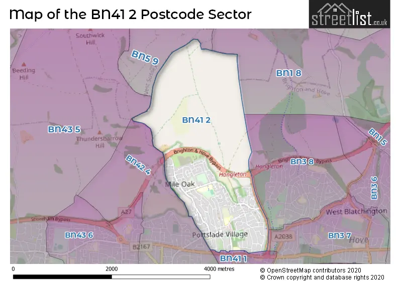
The BN41 2 postcode sector stands on the West Sussex and East Sussex border.
Did you know? According to the 2021 Census, the BN41 2 postcode sector is home to a bustling 14,485 residents!
Given that each sector allows for 400 unique postcode combinations. Letters C, I, K, M, O and V are not allowed in the last two letters of a postcode. With 218 postcodes already in use, this leaves 182 units available.
The BN41 2 postal code covers the settlement of Portslade.
The BN41 2 Postcode shares a border with BN1 8 (BRIGHTON, Patcham), BN3 7 (HOVE), BN41 1 (Portslade), BN42 4 (Southwick), BN43 5 (SHOREHAM-BY-SEA, Shoreham Airport), BN3 8 (HOVE) and BN5 9 (HENFIELD, Small Dole, Woodmancote).
The sector is within the post town of BRIGHTON.
BN41 2 is a postcode sector within the BN41 postcode district which is within the BN Brighton postcode area.
The Royal Mail delivery office for the BN41 2 postal sector is the Portslade Delivery Office.
The area of the BN41 2 postcode sector is 2.68 square miles which is 6.94 square kilometres or 1,714.45 square acres.
The BN41 2 postcode sector is crossed by the A27 Major A road.

Map of the BN41 2 Postcode Sector
Explore the BN41 2 postcode sector by using our free interactive map.
| B | N | 4 | 1 | - | 2 | X | X |
| B | N | 4 | 1 | Space | 2 | Letter | Letter |
Official List of Streets
Portslade (144 Streets)
Unofficial Streets or Alternative Spellings
Weather Forecast for BN41 2
Press Button to Show Forecast for Southwick (West Sussex)
| Time Period | Icon | Description | Temperature | Rain Probability | Wind |
|---|---|---|---|---|---|
| 15:00 to 18:00 | Cloudy | 11.0°C (feels like 8.0°C) | 8.00% | WSW 11 mph | |
| 18:00 to 21:00 | Sunny day | 11.0°C (feels like 8.0°C) | 1.00% | SW 13 mph | |
| 21:00 to 00:00 | Clear night | 10.0°C (feels like 8.0°C) | 0.00% | SW 9 mph |
Press Button to Show Forecast for Southwick (West Sussex)
| Time Period | Icon | Description | Temperature | Rain Probability | Wind |
|---|---|---|---|---|---|
| 00:00 to 03:00 | Clear night | 10.0°C (feels like 7.0°C) | 1.00% | SW 11 mph | |
| 03:00 to 06:00 | Clear night | 9.0°C (feels like 7.0°C) | 1.00% | SW 11 mph | |
| 06:00 to 09:00 | Sunny day | 10.0°C (feels like 8.0°C) | 0.00% | SSW 13 mph | |
| 09:00 to 12:00 | Sunny day | 12.0°C (feels like 9.0°C) | 0.00% | S 13 mph | |
| 12:00 to 15:00 | Sunny day | 13.0°C (feels like 10.0°C) | 0.00% | S 13 mph | |
| 15:00 to 18:00 | Sunny day | 13.0°C (feels like 11.0°C) | 0.00% | S 11 mph | |
| 18:00 to 21:00 | Sunny day | 13.0°C (feels like 11.0°C) | 0.00% | SSE 7 mph | |
| 21:00 to 00:00 | Clear night | 11.0°C (feels like 9.0°C) | 0.00% | SE 9 mph |
Press Button to Show Forecast for Southwick (West Sussex)
| Time Period | Icon | Description | Temperature | Rain Probability | Wind |
|---|---|---|---|---|---|
| 00:00 to 03:00 | Clear night | 10.0°C (feels like 9.0°C) | 0.00% | SE 9 mph | |
| 03:00 to 06:00 | Clear night | 9.0°C (feels like 8.0°C) | 0.00% | SE 7 mph | |
| 06:00 to 09:00 | Sunny day | 11.0°C (feels like 9.0°C) | 2.00% | SE 9 mph | |
| 09:00 to 12:00 | Partly cloudy (day) | 13.0°C (feels like 11.0°C) | 4.00% | SSE 11 mph | |
| 12:00 to 15:00 | Cloudy | 14.0°C (feels like 12.0°C) | 10.00% | SSE 11 mph | |
| 15:00 to 18:00 | Partly cloudy (day) | 15.0°C (feels like 13.0°C) | 8.00% | SSE 11 mph | |
| 18:00 to 21:00 | Partly cloudy (day) | 14.0°C (feels like 13.0°C) | 8.00% | SE 9 mph | |
| 21:00 to 00:00 | Partly cloudy (night) | 11.0°C (feels like 10.0°C) | 8.00% | ESE 7 mph |
Press Button to Show Forecast for Southwick (West Sussex)
| Time Period | Icon | Description | Temperature | Rain Probability | Wind |
|---|---|---|---|---|---|
| 00:00 to 03:00 | Cloudy | 10.0°C (feels like 10.0°C) | 10.00% | SSE 4 mph | |
| 03:00 to 06:00 | Mist | 9.0°C (feels like 8.0°C) | 20.00% | SSE 4 mph | |
| 06:00 to 09:00 | Mist | 10.0°C (feels like 9.0°C) | 21.00% | NNE 4 mph | |
| 09:00 to 12:00 | Cloudy | 13.0°C (feels like 13.0°C) | 16.00% | NE 4 mph | |
| 12:00 to 15:00 | Cloudy | 16.0°C (feels like 15.0°C) | 18.00% | NE 7 mph | |
| 15:00 to 18:00 | Cloudy | 16.0°C (feels like 15.0°C) | 20.00% | W 7 mph | |
| 18:00 to 21:00 | Cloudy | 15.0°C (feels like 14.0°C) | 19.00% | SW 9 mph | |
| 21:00 to 00:00 | Cloudy | 13.0°C (feels like 12.0°C) | 18.00% | NW 9 mph |
Press Button to Show Forecast for Southwick (West Sussex)
| Time Period | Icon | Description | Temperature | Rain Probability | Wind |
|---|---|---|---|---|---|
| 00:00 to 03:00 | Light rain shower (night) | 12.0°C (feels like 10.0°C) | 38.00% | NW 9 mph | |
| 03:00 to 06:00 | Light rain | 11.0°C (feels like 10.0°C) | 46.00% | NNW 7 mph | |
| 06:00 to 09:00 | Overcast | 11.0°C (feels like 10.0°C) | 17.00% | NNW 7 mph | |
| 09:00 to 12:00 | Overcast | 13.0°C (feels like 12.0°C) | 15.00% | NNW 9 mph | |
| 12:00 to 15:00 | Cloudy | 16.0°C (feels like 14.0°C) | 11.00% | NW 9 mph | |
| 15:00 to 18:00 | Partly cloudy (day) | 17.0°C (feels like 15.0°C) | 11.00% | NNW 11 mph | |
| 18:00 to 21:00 | Sunny day | 16.0°C (feels like 14.0°C) | 9.00% | NNW 9 mph | |
| 21:00 to 00:00 | Cloudy | 13.0°C (feels like 12.0°C) | 10.00% | NW 9 mph |
Schools and Places of Education Within the BN41 2 Postcode Sector
Brackenbury Primary School
Community school
Locks Hill, Brighton, East Sussex, BN41 2LA
Head: Miss Lizzie Mullarky
Ofsted Rating: Good
Inspection: 2022-03-02 (788 days ago)
Website: Visit Brackenbury Primary School Website
Phone: 01273418850
Number of Pupils: 167
Hill Park School
Community special school
Foredown Road, Brighton, East Sussex, BN41 2FU
Head: Mrs Rachel Burstow
Ofsted Rating: Outstanding
Inspection: 2022-06-09 (689 days ago)
Website: Visit Hill Park School Website
Phone: 01273422855
Number of Pupils: 201
Mile Oak Primary School
Community school
Graham Avenue, Brighton, East Sussex, BN41 2WN
Head: Mr Luke Lording
Ofsted Rating: Good
Inspection: 2022-03-16 (774 days ago)
Website: Visit Mile Oak Primary School Website
Phone: 01273077114
Number of Pupils: 423
Peter Gladwin Primary School
Community school
Drove Road, Brighton, East Sussex, BN41 2PA
Head: Ms Vicki Strange
Ofsted Rating: Good
Inspection: 2019-02-12 (1902 days ago)
Website: Visit Peter Gladwin Primary School Website
Phone: 01273916592
Number of Pupils: 213
Portslade Aldridge Community Academy
Academy sponsor led
Chalky Road, Brighton, East Sussex, BN41 2WS
Head: Dr Mark Poston
Ofsted Rating: Good
Inspection: 2021-11-17 (893 days ago)
Website: Visit Portslade Aldridge Community Academy Website
Phone: 01273416300
Number of Pupils: 953
St Nicolas CofE Primary School
Voluntary aided school
Locks Hill, Brighton, East Sussex, BN41 2LA
Head: Mr Andy Richbell
Ofsted Rating: Good
Inspection: 2022-11-16 (529 days ago)
Website: Visit St Nicolas CofE Primary School Website
Phone: 01273418026
Number of Pupils: 424
House Prices in the BN41 2 Postcode Sector
| Type of Property | 2018 Average | 2018 Sales | 2017 Average | 2017 Sales | 2016 Average | 2016 Sales | 2015 Average | 2015 Sales |
|---|---|---|---|---|---|---|---|---|
| Detached | £364,804 | 27 | £358,105 | 28 | £394,021 | 21 | £336,826 | 41 |
| Semi-Detached | £332,012 | 96 | £317,608 | 100 | £311,986 | 99 | £287,356 | 92 |
| Terraced | £301,750 | 62 | £310,770 | 63 | £293,578 | 58 | £252,846 | 75 |
| Flats | £194,322 | 18 | £228,609 | 14 | £220,286 | 22 | £182,417 | 26 |
Important Postcodes BN41 2 in the Postcode Sector
BN41 2FU is the postcode for Hillpark Special School, Foredown Road, Hill Park School, Foredown Road, Downs Park School, Foredown Road, Hillpark Lower School, Foredown Road, Hillpark Special School, Foredown Road, Portslade, and Hill Park Upper School, Foredown Road, Portslade
BN41 2LA is the postcode for Brackenbury Primary School, Locks Hill, St. Nicolas' CE Primary School, Locks Hill, and ST NICOLAS CE PRIMARY SCHOOL, LOCKS HILL, PORTSLADE
BN41 2LY is the postcode for Village Centre, 43 Windlesham Close
BN41 2PA is the postcode for Peter Gladwin School, Drove Road
BN41 2PG is the postcode for Sixth Form Centre, Portslade Community College
BN41 2PY is the postcode for North Portslade Childrens Centre & Acorn Nursery, The Rise
BN41 2WF is the postcode for Mile Oak Medical Centre, Chalky Road
BN41 2WN is the postcode for Mile Oak Primary School, Graham Avenue
BN41 2WS is the postcode for SPORTS CENTRE, Portslade Community College, Upper School, Chalky Road, Portslade Community College, Upper School, Chalky Road, and Portslade Community College, Upper School, Chalky Road, Portslade
| The BN41 2 Sector is within these Local Authorities |
|
|---|---|
| The BN41 2 Sector is within these Counties |
|
| The BN41 2 Sector is within these Water Company Areas |
|