The BR6 postcode district is a postal district located in the BR Bromley postcode area with a population of 48,041 residents according to the 2021 England and Wales Census.
The area of the BR6 postcode district is 14.54 square miles which is 37.65 square kilometres or 9,303.42 acres.
Currently, the BR6 district has about 1135 postcode units spread across 5 geographic postcode sectors.
Given that each sector allows for 400 unique postcode combinations, the district has a capacity of 2,000 postcodes. With 1135 postcodes already in use, this leaves 865 units available.
The BR6 postal code covers the settlement of ORPINGTON.
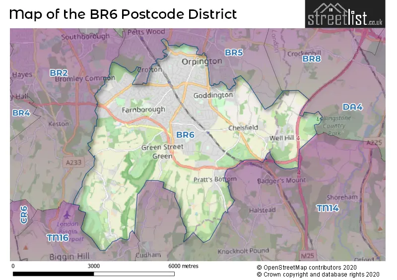
The BR6 Postcode shares a border with BR2 (BROMLEY, HAYES, SHORTLANDS), BR5 (ORPINGTON, PETTS WOOD), DA4 (South Darenth, EYNSFORD, Sutton At Hone), TN14 (OTFORD, SEVENOAKS, HALSTEAD) and TN16 (BIGGIN HILL, WESTERHAM).
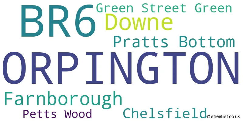
The primary settlement in the BR6 postcode district is Orpington, located in the county of Greater London in England. Other significant settlements in this district include Petts Wood, Chelsfield, Green Street Green, Downe, Farnborough, and Pratts Bottom. The most significant post town in this district is Orpington.
For the district BR6, we have data on 6 postcode sectors. Here's a breakdown: The sector BR6 0, covers Orpington in Greater London. The sector BR6 1 is non-geographic. It's often designated for PO Boxes, large organisations, or special services. The sector BR6 6, covers Orpington in Greater London. The sector BR6 7, covers Orpington and Downe in Greater London. The sector BR6 8, covers Orpington in Greater London. The sector BR6 9, covers Orpington in Greater London.

Map of the BR6 Postcode District
Explore the BR6 postcode district by using our free interactive map.
When it comes to local government, postal geography often disregards political borders. However, for a breakdown in the BR6 District: the district mostly encompasses the Bromley London Boro (1119 postcodes), and finally, the Sevenoaks District area (20 postcodes).
Weather Forecast for BR6
Press Button to Show Forecast for Orpington
| Time Period | Icon | Description | Temperature | Rain Probability | Wind |
|---|---|---|---|---|---|
| 06:00 to 09:00 | Light rain | 7.0°C (feels like 4.0°C) | 53.00% | NE 9 mph | |
| 09:00 to 12:00 | Overcast | 8.0°C (feels like 6.0°C) | 15.00% | ENE 9 mph | |
| 12:00 to 15:00 | Light rain | 11.0°C (feels like 9.0°C) | 53.00% | NE 7 mph | |
| 15:00 to 18:00 | Cloudy | 12.0°C (feels like 11.0°C) | 49.00% | ENE 7 mph | |
| 18:00 to 21:00 | Light rain | 11.0°C (feels like 9.0°C) | 51.00% | ENE 9 mph | |
| 21:00 to 00:00 | Heavy rain | 9.0°C (feels like 7.0°C) | 89.00% | NE 11 mph |
Press Button to Show Forecast for Orpington
| Time Period | Icon | Description | Temperature | Rain Probability | Wind |
|---|---|---|---|---|---|
| 00:00 to 03:00 | Heavy rain | 9.0°C (feels like 6.0°C) | 91.00% | NE 9 mph | |
| 03:00 to 06:00 | Heavy rain | 9.0°C (feels like 7.0°C) | 88.00% | NNE 9 mph | |
| 06:00 to 09:00 | Heavy rain | 9.0°C (feels like 7.0°C) | 84.00% | ENE 9 mph | |
| 09:00 to 12:00 | Heavy rain | 9.0°C (feels like 7.0°C) | 81.00% | W 11 mph | |
| 12:00 to 15:00 | Heavy rain | 10.0°C (feels like 7.0°C) | 76.00% | NW 13 mph | |
| 15:00 to 18:00 | Light rain shower (day) | 10.0°C (feels like 8.0°C) | 39.00% | W 11 mph | |
| 18:00 to 21:00 | Cloudy | 10.0°C (feels like 8.0°C) | 9.00% | WSW 9 mph | |
| 21:00 to 00:00 | Clear night | 8.0°C (feels like 6.0°C) | 3.00% | SW 7 mph |
Press Button to Show Forecast for Orpington
| Time Period | Icon | Description | Temperature | Rain Probability | Wind |
|---|---|---|---|---|---|
| 00:00 to 03:00 | Clear night | 7.0°C (feels like 5.0°C) | 2.00% | SW 7 mph | |
| 03:00 to 06:00 | Clear night | 6.0°C (feels like 4.0°C) | 1.00% | SSW 4 mph | |
| 06:00 to 09:00 | Sunny day | 7.0°C (feels like 5.0°C) | 1.00% | S 4 mph | |
| 09:00 to 12:00 | Partly cloudy (day) | 11.0°C (feels like 10.0°C) | 3.00% | S 9 mph | |
| 12:00 to 15:00 | Cloudy | 14.0°C (feels like 11.0°C) | 8.00% | S 11 mph | |
| 15:00 to 18:00 | Partly cloudy (day) | 14.0°C (feels like 12.0°C) | 2.00% | S 11 mph | |
| 18:00 to 21:00 | Sunny day | 13.0°C (feels like 11.0°C) | 4.00% | S 7 mph | |
| 21:00 to 00:00 | Clear night | 9.0°C (feels like 8.0°C) | 2.00% | SE 7 mph |
Press Button to Show Forecast for Orpington
| Time Period | Icon | Description | Temperature | Rain Probability | Wind |
|---|---|---|---|---|---|
| 00:00 to 03:00 | Clear night | 8.0°C (feels like 7.0°C) | 2.00% | SE 7 mph | |
| 03:00 to 06:00 | Partly cloudy (night) | 8.0°C (feels like 6.0°C) | 3.00% | ESE 7 mph | |
| 06:00 to 09:00 | Cloudy | 9.0°C (feels like 7.0°C) | 8.00% | ESE 7 mph | |
| 09:00 to 12:00 | Cloudy | 13.0°C (feels like 11.0°C) | 8.00% | SE 9 mph | |
| 12:00 to 15:00 | Cloudy | 15.0°C (feels like 14.0°C) | 14.00% | SE 9 mph | |
| 15:00 to 18:00 | Cloudy | 16.0°C (feels like 14.0°C) | 13.00% | SE 9 mph | |
| 18:00 to 21:00 | Cloudy | 15.0°C (feels like 13.0°C) | 11.00% | SE 7 mph | |
| 21:00 to 00:00 | Cloudy | 12.0°C (feels like 10.0°C) | 16.00% | ESE 7 mph |
Where is the BR6 Postcode District?
The postcode district for BR6 is located in Orpington. It is in close proximity to several nearby towns, including Green Street Green to the South, Pratts Bottom to the South East, Farnborough to the West, Chelsfield to the East, Downe to the South West, and Petts Wood to the North. Additionally, Orpington is approximately 14.3 miles away from the center of London.
The district is within the post town of ORPINGTON.
The sector has postcodes within the nation of England.
The BR6 Postcode District is covers the following regions.
- Bromley - Outer London - South - London
- West Kent - Kent - South East (England)
| Postcode Sector | Delivery Office |
|---|---|
| BR6 0 | Orpington Delivery Office |
| BR6 6 | Orpington Delivery Office |
| BR6 7 | Orpington Delivery Office |
| BR6 8 | Orpington Delivery Office |
| BR6 9 | Orpington Delivery Office |
| B | R | 6 | - | X | X | X |
| B | R | 6 | Space | Numeric | Letter | Letter |
Tourist Attractions within the Postcode Area
We found 1 visitor attractions within the BR6 postcode area
| Down House - Home of Charles Darwin |
|---|
| Historic Properties |
| Historic House / House and Garden / Palace |
| View Down House - Home of Charles Darwin on Google Maps |
Current Monthly Rental Prices
| # Bedrooms | Min Price | Max Price | Avg Price |
|---|---|---|---|
| 1 | £1,400 | £1,500 | £1,433 |
| 2 | £1,450 | £1,872 | £1,699 |
| 3 | £2,000 | £2,400 | £2,225 |
| 4 | £2,350 | £2,900 | £2,679 |
| 5 | £5,500 | £5,500 | £5,500 |
Current House Prices
| # Bedrooms | Min Price | Max Price | Avg Price |
|---|---|---|---|
| 3 | £1,650,000 | £1,650,000 | £1,650,000 |
| 4 | £1,375,000 | £2,000,000 | £1,635,000 |
| 5 | £1,450,000 | £4,950,000 | £2,316,154 |
| 6 | £1,400,000 | £4,250,000 | £2,650,000 |
Estate Agents who Operate in the BR6 District
| Logo | Name | Brand Name | Address | Contact Number | Total Properties |
|---|---|---|---|---|---|
 | Orpington | Thomas Brown Estates | 285 High Street, Orpington, BR6 0NN | 01689 884444 | 32 |
 | Locksbottom | jdm | Alexandre House, 399 Crofton Road, Farnborough, Orpington, BR6 8NL | 01689 663754 | 28 |
 | Locksbottom | Alan de Maid | 9 Princess Parade Crofton Road Orpington BR6 8NP | 01689 661649 | 28 |
 | Orpington | Alan de Maid | 182 High Street Orpington BR6 0JW | 01689 661648 | 21 |
 | Orpington | Langford Russell | 280 High Street, Orpington, BR6 0ND | 01689 664636 | 19 |
| Type of Property | 2018 Average | 2018 Sales | 2017 Average | 2017 Sales | 2016 Average | 2016 Sales | 2015 Average | 2015 Sales |
|---|---|---|---|---|---|---|---|---|
| Detached | £768,922 | 212 | £796,840 | 201 | £741,439 | 218 | £736,411 | 285 |
| Semi-Detached | £528,653 | 229 | £509,630 | 250 | £477,891 | 255 | £436,893 | 279 |
| Terraced | £421,240 | 150 | £404,309 | 143 | £382,820 | 153 | £338,225 | 173 |
| Flats | £339,012 | 167 | £297,434 | 157 | £268,946 | 142 | £264,062 | 86 |