The BR8 postcode district is a postal district located in the BR Bromley postcode area with a population of 23,730 residents according to the 2021 England and Wales Census.
The area of the BR8 postcode district is 8.17 square miles which is 21.15 square kilometres or 5,226.35 acres.
Currently, the BR8 district has about 486 postcode units spread across 2 geographic postcode sectors.
Given that each sector allows for 400 unique postcode combinations, the district has a capacity of 800 postcodes. With 486 postcodes already in use, this leaves 314 units available.
The largest settlements in the BR8 postal code are SWANLEY and HEXTABLE.
The BR8 Postcode shares a border with DA2 (DARTFORD, WILMINGTON, DARENTH), BR5 (ORPINGTON, PETTS WOOD), DA14 (SIDCUP) and DA4 (South Darenth, EYNSFORD, Sutton At Hone).
The primary settlement in the BR8 postcode district is Swanley, located in Greater London. Other significant settlements in the district include Hextable and Crockenhill, both located in Kent. The most significant post town in the district is Swanley. The county within which Swanley is located is Greater London, while Hextable and Crockenhill are in Kent.
For the district BR8, we have data on 3 postcode sectors. Here's a breakdown: The sector BR8 7, covers Swanley and Hextable in Kent. The sector BR8 8, covers Swanley and Crockenhill in Kent. The sector BR8 9 is non-geographic. It's often designated for PO Boxes, large organisations, or special services.

Map of the BR8 Postcode District
Explore the BR8 postcode district by using our free interactive map.
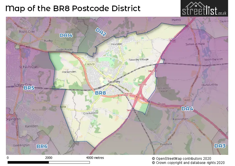
When it comes to local government, postal geography often disregards political borders. However, for a breakdown in the BR8 District: the district mostly encompasses the Sevenoaks District (470 postcodes), followed by the Bromley London Boro area (10 postcodes), and finally, the Dartford District (B) area (4 postcodes).
Where is the BR8 Postcode District?
The postcode district for BR8 is located in Swanley. Swanley is a town that is geographically positioned in the North West of London Road, South East of Moreton Industrial Estate, South of Crockenhill, North East of Swanley Village, North of Woodside Drive, and West of St Pauls Cray. Additionally, Swanley is approximately 15.18 miles away from the center of London.
The district is within the post town of SWANLEY.
The sector has postcodes within the nation of England.
The BR8 Postcode District is covers the following regions.
- West Kent - Kent - South East (England)
- Kent Thames Gateway - Kent - South East (England)
- Bromley - Outer London - South - London
Weather Forecast for BR8
Press Button to Show Forecast for Swanley
| Time Period | Icon | Description | Temperature | Rain Probability | Wind |
|---|---|---|---|---|---|
| 15:00 to 18:00 | Partly cloudy (day) | 23.0°C (feels like 22.0°C) | 1.00% | E 9 mph | |
| 18:00 to 21:00 | Cloudy | 21.0°C (feels like 20.0°C) | 4.00% | ESE 7 mph | |
| 21:00 to 00:00 | Cloudy | 17.0°C (feels like 16.0°C) | 4.00% | S 4 mph |
Press Button to Show Forecast for Swanley
| Time Period | Icon | Description | Temperature | Rain Probability | Wind |
|---|---|---|---|---|---|
| 00:00 to 03:00 | Clear night | 15.0°C (feels like 14.0°C) | 2.00% | SSW 4 mph | |
| 03:00 to 06:00 | Clear night | 13.0°C (feels like 12.0°C) | 1.00% | SSW 7 mph | |
| 06:00 to 09:00 | Partly cloudy (day) | 13.0°C (feels like 12.0°C) | 2.00% | SSW 9 mph | |
| 09:00 to 12:00 | Partly cloudy (day) | 16.0°C (feels like 15.0°C) | 1.00% | SSW 9 mph | |
| 12:00 to 15:00 | Partly cloudy (day) | 19.0°C (feels like 16.0°C) | 1.00% | S 13 mph | |
| 15:00 to 18:00 | Partly cloudy (day) | 19.0°C (feels like 16.0°C) | 1.00% | S 13 mph | |
| 18:00 to 21:00 | Cloudy | 18.0°C (feels like 16.0°C) | 5.00% | SSE 9 mph | |
| 21:00 to 00:00 | Cloudy | 16.0°C (feels like 15.0°C) | 8.00% | ESE 9 mph |
Press Button to Show Forecast for Swanley
| Time Period | Icon | Description | Temperature | Rain Probability | Wind |
|---|---|---|---|---|---|
| 00:00 to 03:00 | Cloudy | 15.0°C (feels like 14.0°C) | 9.00% | SE 9 mph | |
| 03:00 to 06:00 | Cloudy | 14.0°C (feels like 13.0°C) | 16.00% | ESE 7 mph | |
| 06:00 to 09:00 | Light rain | 14.0°C (feels like 13.0°C) | 56.00% | ESE 7 mph | |
| 09:00 to 12:00 | Heavy rain | 15.0°C (feels like 14.0°C) | 82.00% | SE 9 mph | |
| 12:00 to 15:00 | Light rain | 16.0°C (feels like 14.0°C) | 60.00% | S 9 mph | |
| 15:00 to 18:00 | Light rain | 16.0°C (feels like 14.0°C) | 52.00% | S 9 mph | |
| 18:00 to 21:00 | Cloudy | 15.0°C (feels like 14.0°C) | 15.00% | SSE 9 mph | |
| 21:00 to 00:00 | Cloudy | 14.0°C (feels like 12.0°C) | 9.00% | SE 7 mph |
Press Button to Show Forecast for Swanley
| Time Period | Icon | Description | Temperature | Rain Probability | Wind |
|---|---|---|---|---|---|
| 00:00 to 03:00 | Cloudy | 13.0°C (feels like 12.0°C) | 7.00% | SE 7 mph | |
| 03:00 to 06:00 | Cloudy | 12.0°C (feels like 11.0°C) | 6.00% | SE 4 mph | |
| 06:00 to 09:00 | Sunny day | 13.0°C (feels like 12.0°C) | 7.00% | SE 4 mph | |
| 09:00 to 12:00 | Partly cloudy (day) | 16.0°C (feels like 14.0°C) | 7.00% | SSE 7 mph | |
| 12:00 to 15:00 | Partly cloudy (day) | 18.0°C (feels like 16.0°C) | 6.00% | SSE 9 mph | |
| 15:00 to 18:00 | Partly cloudy (day) | 18.0°C (feels like 17.0°C) | 4.00% | SSE 9 mph | |
| 18:00 to 21:00 | Sunny day | 17.0°C (feels like 16.0°C) | 4.00% | SSE 7 mph | |
| 21:00 to 00:00 | Clear night | 13.0°C (feels like 13.0°C) | 3.00% | SE 4 mph |
Press Button to Show Forecast for Swanley
| Time Period | Icon | Description | Temperature | Rain Probability | Wind |
|---|---|---|---|---|---|
| 00:00 to 03:00 | Clear night | 11.0°C (feels like 11.0°C) | 1.00% | SE 4 mph | |
| 03:00 to 06:00 | Partly cloudy (night) | 11.0°C (feels like 10.0°C) | 2.00% | ESE 2 mph | |
| 06:00 to 09:00 | Cloudy | 12.0°C (feels like 12.0°C) | 7.00% | NE 2 mph | |
| 09:00 to 12:00 | Cloudy | 16.0°C (feels like 16.0°C) | 7.00% | E 4 mph | |
| 12:00 to 15:00 | Cloudy | 18.0°C (feels like 18.0°C) | 10.00% | SE 4 mph | |
| 15:00 to 18:00 | Light rain shower (day) | 19.0°C (feels like 18.0°C) | 32.00% | SSW 7 mph | |
| 18:00 to 21:00 | Light rain shower (day) | 17.0°C (feels like 17.0°C) | 31.00% | SSW 4 mph | |
| 21:00 to 00:00 | Cloudy | 14.0°C (feels like 14.0°C) | 10.00% | SSW 4 mph |
| Postcode Sector | Delivery Office |
|---|---|
| BR8 7 | Swanley Delivery Office |
| BR8 8 | Swanley Delivery Office |
| B | R | 8 | - | X | X | X |
| B | R | 8 | Space | Numeric | Letter | Letter |
Current Monthly Rental Prices
| # Bedrooms | Min Price | Max Price | Avg Price |
|---|---|---|---|
| 1 | £800 | £1,050 | £900 |
| 2 | £1,500 | £2,300 | £1,900 |
| 3 | £1,800 | £1,950 | £1,883 |
| 4 | £1,925 | £1,925 | £1,925 |
| 5 | £3,000 | £3,000 | £3,000 |
Current House Prices
| # Bedrooms | Min Price | Max Price | Avg Price |
|---|---|---|---|
| 3 | £635,000 | £635,000 | £635,000 |
| 4 | £600,000 | £1,750,000 | £775,000 |
| 5 | £725,000 | £1,245,000 | £878,333 |
| 6 | £624,995 | £1,875,000 | £1,224,999 |
Estate Agents who Operate in the BR8 District
| Logo | Name | Brand Name | Address | Contact Number | Total Properties |
|---|---|---|---|---|---|
 | Swanley Resale | Robinson Jackson | 39 High Street, Swanley, BR8 8AE | 01322 952125 | 40 |
 | Swanley | Langford Russell | 8 High Street, Swanley, BR8 8BE | 020 3834 8516 | 27 |
 | Swanley | Brookbanks Estate Agents | 41 High Street Swanley Kent BR8 8AE | 01322 936520 | 22 |
 | Swanley | Your Move | 43 High Street, Swanley, BR8 8AE | 01322 952565 | 12 |
 | Eynsford | Wards | Harlend House, High Street, Eynsford, Dartford, DA4 0AB | 01322 936164 | 5 |
Yearly House Price Averages for the BR8 Postcode District
| Type of Property | 2018 Average | 2018 Sales | 2017 Average | 2017 Sales | 2016 Average | 2016 Sales | 2015 Average | 2015 Sales |
|---|---|---|---|---|---|---|---|---|
| Detached | £553,651 | 40 | £454,388 | 50 | £464,671 | 35 | £398,100 | 33 |
| Semi-Detached | £356,285 | 142 | £358,410 | 135 | £335,188 | 127 | £290,654 | 122 |
| Terraced | £316,113 | 108 | £322,215 | 106 | £284,053 | 105 | £250,379 | 109 |
| Flats | £250,326 | 49 | £200,724 | 49 | £191,962 | 79 | £163,111 | 54 |