The BS3 5 postcode sector is within the county of Bristol.
Did you know? According to the 2021 Census, the BS3 5 postcode sector is home to a bustling 9,378 residents!
Given that each sector allows for 400 unique postcode combinations. Letters C, I, K, M, O and V are not allowed in the last two letters of a postcode. With 180 postcodes already in use, this leaves 220 units available.
The largest settlements in the BS3 5 postal code are BRISTOL and Bedminster.
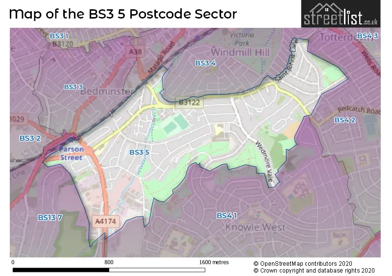
The BS3 5 Postcode shares a border with BS4 1 (BRISTOL, Knowle), BS3 3 (BRISTOL, Bedminster), BS3 4 (BRISTOL, Bedminster, Totterdown), BS4 2 (BRISTOL, Knowle, Totterdown) and BS13 7 (BRISTOL, Bishopsworth, Bedminster Down).
The sector is within the post town of BRISTOL.
BS3 5 is a postcode sector within the BS3 postcode district which is within the BS Bristol postcode area.
The Royal Mail delivery office for the BS3 5 postal sector is the Bristol South Delivery Office.
The area of the BS3 5 postcode sector is 0.65 square miles which is 1.68 square kilometres or 415.38 square acres.
Waterways within the BS3 5 postcode sector include the Malago.

Map of the BS3 5 Postcode Sector
Explore the BS3 5 postcode sector by using our free interactive map.
| B | S | 3 | - | 5 | X | X |
| B | S | 3 | Space | 5 | Letter | Letter |
Official List of Streets
BRISTOL (58 Streets)
Unofficial Streets or Alternative Spellings
BRISTOL
ALMORAH ROAD ATLAS ROAD BRENDON ROAD COTSWOLD ROAD MAIDSTONE STREET MARGATE STREET MARMADUKE STREET MERIONETH STREET MONMOUTH STREET MONTGOMERY STREET NEWPORT STREET NOTTINGHAM STREET NOVERS LANE PAULTOW ROAD RAYMEND ROAD AVONDOWN COURT DICKINSONS FIELD FILWOOD GREENWAY HONEYWICKE CLOSE KINGSWEAR ROAD MALAGO GREENWAY MALAGO VALE ESTATE MASONS CLOSE SAINT AGNES AVENUE SAINT AGNES WALK SAINT JOHNS CRESCENT SAINT JOHNS LANE ST AGNES AVENUE ST AGNES WALK ST LUKES ROAD TORPOINT ROAD WATER LANEWeather Forecast for BS3 5
Press Button to Show Forecast for Bedminster
| Time Period | Icon | Description | Temperature | Rain Probability | Wind |
|---|---|---|---|---|---|
| 03:00 to 06:00 | Overcast | 7.0°C (feels like 5.0°C) | 8.00% | ENE 4 mph | |
| 06:00 to 09:00 | Cloudy | 6.0°C (feels like 4.0°C) | 8.00% | ENE 7 mph | |
| 09:00 to 12:00 | Cloudy | 8.0°C (feels like 6.0°C) | 11.00% | E 9 mph | |
| 12:00 to 15:00 | Overcast | 10.0°C (feels like 8.0°C) | 15.00% | E 9 mph | |
| 15:00 to 18:00 | Overcast | 11.0°C (feels like 9.0°C) | 19.00% | E 9 mph | |
| 18:00 to 21:00 | Overcast | 10.0°C (feels like 8.0°C) | 19.00% | E 7 mph | |
| 21:00 to 00:00 | Cloudy | 8.0°C (feels like 7.0°C) | 16.00% | ENE 7 mph |
Press Button to Show Forecast for Bedminster
| Time Period | Icon | Description | Temperature | Rain Probability | Wind |
|---|---|---|---|---|---|
| 00:00 to 03:00 | Cloudy | 7.0°C (feels like 5.0°C) | 14.00% | ENE 7 mph | |
| 03:00 to 06:00 | Cloudy | 6.0°C (feels like 4.0°C) | 14.00% | ENE 7 mph | |
| 06:00 to 09:00 | Cloudy | 6.0°C (feels like 3.0°C) | 18.00% | ENE 9 mph | |
| 09:00 to 12:00 | Light rain | 8.0°C (feels like 5.0°C) | 50.00% | ENE 11 mph | |
| 12:00 to 15:00 | Overcast | 10.0°C (feels like 8.0°C) | 21.00% | NE 11 mph | |
| 15:00 to 18:00 | Cloudy | 11.0°C (feels like 9.0°C) | 19.00% | ENE 11 mph | |
| 18:00 to 21:00 | Light rain | 11.0°C (feels like 8.0°C) | 48.00% | NE 9 mph | |
| 21:00 to 00:00 | Light rain | 9.0°C (feels like 7.0°C) | 48.00% | NE 11 mph |
Press Button to Show Forecast for Bedminster
| Time Period | Icon | Description | Temperature | Rain Probability | Wind |
|---|---|---|---|---|---|
| 00:00 to 03:00 | Light rain | 8.0°C (feels like 6.0°C) | 51.00% | NE 9 mph | |
| 03:00 to 06:00 | Light rain | 8.0°C (feels like 5.0°C) | 52.00% | NE 9 mph | |
| 06:00 to 09:00 | Light rain | 8.0°C (feels like 5.0°C) | 52.00% | NE 9 mph | |
| 09:00 to 12:00 | Light rain | 9.0°C (feels like 7.0°C) | 50.00% | NNE 9 mph | |
| 12:00 to 15:00 | Heavy rain shower (day) | 11.0°C (feels like 9.0°C) | 61.00% | N 11 mph | |
| 15:00 to 18:00 | Heavy rain shower (day) | 12.0°C (feels like 10.0°C) | 58.00% | NW 11 mph | |
| 18:00 to 21:00 | Light rain shower (day) | 12.0°C (feels like 10.0°C) | 35.00% | NNW 9 mph | |
| 21:00 to 00:00 | Clear night | 9.0°C (feels like 8.0°C) | 7.00% | NW 7 mph |
Schools and Places of Education Within the BS3 5 Postcode Sector
Oasis Academy Marksbury Road
Academy sponsor led
Marksbury Road, Bedminster, Bristol, BS3 5JL
Head: Mr Alex Dart
Ofsted Rating: Outstanding
Inspection: 2018-07-11 (2116 days ago)
Website: Visit Oasis Academy Marksbury Road Website
Phone: 01173126500
Number of Pupils: 394
Parson Street Primary School
Academy converter
Bedminster Road, Bristol, , BS3 5NR
Head: Mr Laurie Munro
Ofsted Rating: Requires improvement
Inspection: 2022-03-03 (785 days ago)
Website: Visit Parson Street Primary School Website
Phone: 01179030226
Number of Pupils: 353
House Prices in the BS3 5 Postcode Sector
| Type of Property | 2018 Average | 2018 Sales | 2017 Average | 2017 Sales | 2016 Average | 2016 Sales | 2015 Average | 2015 Sales |
|---|---|---|---|---|---|---|---|---|
| Detached | £469,085 | 20 | £364,178 | 11 | £0 | 0 | £0 | 0 |
| Semi-Detached | £307,259 | 47 | £296,129 | 46 | £230,472 | 29 | £220,071 | 35 |
| Terraced | £304,741 | 101 | £285,187 | 85 | £261,240 | 63 | £226,420 | 49 |
| Flats | £212,451 | 41 | £177,512 | 38 | £170,013 | 38 | £148,792 | 33 |
Important Postcodes BS3 5 in the Postcode Sector
BS3 5AS is the postcode for St. Johns Lane Health Centre, St. Johns Lane
BS3 5JL is the postcode for NEW BUILDING, City of Bristol College, Bedminster Centre, Marksbury Road, OLD BUILDING, City of Bristol College, Bedminster Centre, Marksbury Road, Oasis Academy, Marksbury Road, OLD WORKSHOP BUILDING, City of Bristol College, Bedminster Centre, Marksbury Road, and Oasis Academy Marksbury Road, Marksbury Road, Bedminster
BS3 5NR is the postcode for NEW BLOCK PARSON STREET PRIMARY SCHOOL, Parson Street Primary School, Bedminster Road, Parson Street Primary School, Bedminster Road, Bedminster, and Parson Street Primary School, Bedminster Road
BS3 5RN is the postcode for Avon Fire & Rescue Service, Fire Station, 61 Hartcliffe Way, and Bedminster Fire Station, 61 Hartcliffe Way, Knowle
| The BS3 5 Sector is within these Local Authorities |
|
|---|---|
| The BS3 5 Sector is within these Counties |
|
| The BS3 5 Sector is within these Water Company Areas |
|