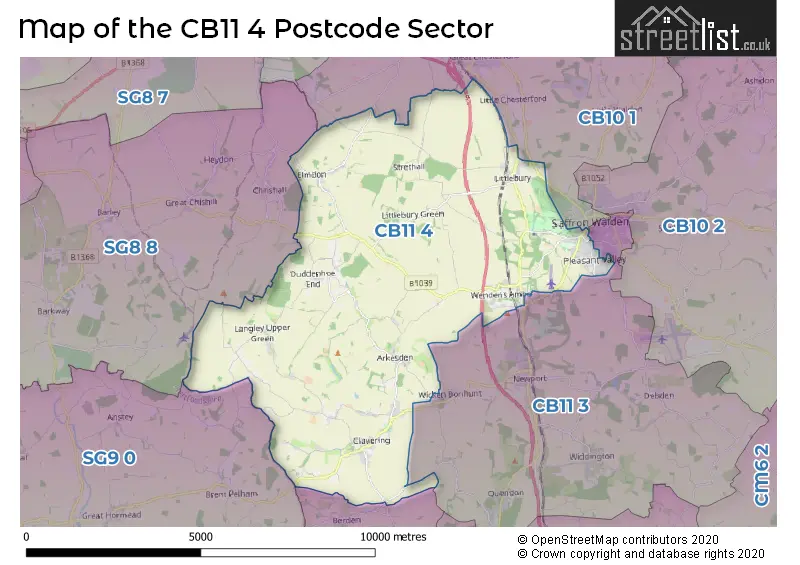
The CB11 4 postcode sector lies where the three counties of Cambridgeshire, Essex, and Hertfordshire meet.
Did you know? According to the 2021 Census, the CB11 4 postcode sector is home to a bustling 8,808 residents!
Given that each sector allows for 400 unique postcode combinations. Letters C, I, K, M, O and V are not allowed in the last two letters of a postcode. With 237 postcodes already in use, this leaves 163 units available.
The largest settlement in the CB11 4 postal code is SAFFRON WALDEN followed by Clavering, and Wendens Ambo.
The CB11 4 Postcode shares a border with CB10 1 (SAFFRON WALDEN, Great Chesterford, Ickleton), CM23 1 (BISHOP'S STORTFORD, Manuden, Farnham), SG8 8 (Barkway, Barley, Chrishall), SG9 0 (Sandon, Furneux Pelham, Rushden) and CB11 3 (SAFFRON WALDEN, Newport, Debden).
The sector is within the post town of SAFFRON WALDEN.
CB11 4 is a postcode sector within the CB11 postcode district which is within the CB Cambridge postcode area.
The Royal Mail delivery office for the CB11 4 postal sector is the Saffron Walden Delivery Office and Arkesden Scale Payment Delivery Office.
The area of the CB11 4 postcode sector is 28.16 square miles which is 72.95 square kilometres or 18,025.18 square acres.
The CB11 4 postcode sector is crossed by the M11 motorway.
Waterways within the CB11 4 postcode sector include the River Cam.

Map of the CB11 4 Postcode Sector
Explore the CB11 4 postcode sector by using our free interactive map.
| C | B | 1 | 1 | - | 4 | X | X |
| C | B | 1 | 1 | Space | 4 | Letter | Letter |
Official List of Streets
SAFFRON WALDEN (56 Streets)
Clavering (31 Streets)
Duddenhoe End (5 Streets)
Langley Upper Green (4 Streets)
Elmdon (12 Streets)
Littlebury (17 Streets)
Wendens Ambo (11 Streets)
Arkesden (9 Streets)
Langley Lower Green (2 Streets)
Wenden Lofts (1 Streets)
Audley End (1 Streets)
Unofficial Streets or Alternative Spellings
SAFFRON WALDEN
GREENWAYS HIGH STREET HILL TOP LANE MOUNT PLEASANT ROAD STATION ROAD WEST ROAD WINDMILL HILL WINSTANLEY ROAD ADAM BRIDGE ADCOCKS LANE ARKESDEN ROAD (CLATTERBURY LANE) AUDLEY END BATTS LANE BEARDS LANE BEARDS LANE; HAMPIT ROAD BEARWALDEN BUSINESS PARK BEECHY RIDE PATH BEECHY RIDE TRACK BERDEN ROAD BIRCH LANE BRIDGE GREEN ROAD BROMLEY LANE BROOKSIES CAKEBREADS LANE CHALK PIT LANE CHALKPIT LANE CHAPEL GREEN ROAD CHESTNUT AVENUE CHINNEL LANE CHURCH LANE CLATTERBURY LANE CLAVERING ROAD (CLATTERBURY LANE) CLEMENTS CLOSE COCK LANE COGMORE COLEHILL LANE COOPERS END ROAD DARK LANE DEVILS LANE DUDDENHOE LANE ELMDON ROAD ELMSTREET LANE ESSEX HILL FIELDSIDE FORD END ROAD FRIENDS WK FURTHER FORD END ROAD HIGHFIELD HIGHFIELD LANE HUNTERS YARD ICKNIELD WAY ICKNIELD WAY TRAIL LANGLEY LOWER GREEN LANGLEY ROAD LITTLE CHISHILL ROAD LONG LANE LORKINGS LANE LOWER GREEN LOWER ROAD MANUDEN ROAD MEESDEN BRIDGE MILLS ROAD MOUNT PLEASANT COTTAGES MUTLOW HILL OLD SCHOOL YARD OSTLERS GREEN PARK LANE PARKHOUSE LANE PARSONAGE LANE PAVILLION WAY PIPERS LANE PLANTATION HILL POOR BRIDGE POOR BRIDGE ROAD POOR BRIDGE ROAD; CHURCH END POORE STREET QUICKSET ROAD ROBINSONS BUNGALOWS ROCKELLS LANE ROPERS LANE SAFFRON TRAIL SHEEPCOTE GREEN LANE SPARROWSEND HILL SPRING HILL SPRINGWELL ROAD STABLE BRIDGE STARLINGS GREEN ROAD STEVENS LANE STRETHALL CHURCH LANE SUMMER HILL ROAD THE BEECHES THE CAUSEWAY THE GAP THE HIDE THE WANTS THE WILLOWS THOMAS WALK TRINITY COURT UP END UTTLESFORD BRIDGE WATERY STONES WELL-GREEN CLOSE WENDEN COURT WICKEN ROAD (POORE STREET) WOODMANS LANEIckleton
COPLOE ROADElmdon
BURY GARDENSChrishall
HERTFORD LANEWeather Forecast for CB11 4
Press Button to Show Forecast for Duddenhoe End
| Time Period | Icon | Description | Temperature | Rain Probability | Wind |
|---|---|---|---|---|---|
| 18:00 to 21:00 | Sunny day | 14.0°C (feels like 12.0°C) | 0.00% | NNE 11 mph | |
| 21:00 to 00:00 | Partly cloudy (night) | 9.0°C (feels like 8.0°C) | 1.00% | NNE 4 mph |
Press Button to Show Forecast for Duddenhoe End
| Time Period | Icon | Description | Temperature | Rain Probability | Wind |
|---|---|---|---|---|---|
| 00:00 to 03:00 | Overcast | 9.0°C (feels like 7.0°C) | 8.00% | NNE 4 mph | |
| 03:00 to 06:00 | Fog | 8.0°C (feels like 7.0°C) | 15.00% | NNE 4 mph | |
| 06:00 to 09:00 | Mist | 8.0°C (feels like 7.0°C) | 14.00% | NNE 4 mph | |
| 09:00 to 12:00 | Cloudy | 11.0°C (feels like 10.0°C) | 4.00% | NNE 4 mph | |
| 12:00 to 15:00 | Partly cloudy (day) | 15.0°C (feels like 15.0°C) | 0.00% | NE 4 mph | |
| 15:00 to 18:00 | Partly cloudy (day) | 17.0°C (feels like 17.0°C) | 0.00% | NNE 4 mph | |
| 18:00 to 21:00 | Sunny day | 17.0°C (feels like 16.0°C) | 1.00% | ENE 4 mph | |
| 21:00 to 00:00 | Clear night | 11.0°C (feels like 9.0°C) | 1.00% | SE 9 mph |
Press Button to Show Forecast for Duddenhoe End
| Time Period | Icon | Description | Temperature | Rain Probability | Wind |
|---|---|---|---|---|---|
| 00:00 to 03:00 | Cloudy | 10.0°C (feels like 8.0°C) | 4.00% | SSE 9 mph | |
| 03:00 to 06:00 | Cloudy | 9.0°C (feels like 8.0°C) | 4.00% | S 7 mph | |
| 06:00 to 09:00 | Mist | 11.0°C (feels like 10.0°C) | 12.00% | SSW 4 mph | |
| 09:00 to 12:00 | Sunny day | 16.0°C (feels like 16.0°C) | 1.00% | SSW 4 mph | |
| 12:00 to 15:00 | Partly cloudy (day) | 19.0°C (feels like 18.0°C) | 4.00% | WSW 2 mph | |
| 15:00 to 18:00 | Cloudy | 19.0°C (feels like 19.0°C) | 6.00% | SSW 4 mph | |
| 18:00 to 21:00 | Partly cloudy (day) | 18.0°C (feels like 18.0°C) | 2.00% | SE 4 mph | |
| 21:00 to 00:00 | Cloudy | 13.0°C (feels like 12.0°C) | 3.00% | ESE 7 mph |
Press Button to Show Forecast for Duddenhoe End
| Time Period | Icon | Description | Temperature | Rain Probability | Wind |
|---|---|---|---|---|---|
| 00:00 to 03:00 | Cloudy | 11.0°C (feels like 10.0°C) | 4.00% | SSE 4 mph | |
| 03:00 to 06:00 | Cloudy | 10.0°C (feels like 9.0°C) | 4.00% | SSE 4 mph | |
| 06:00 to 09:00 | Cloudy | 12.0°C (feels like 11.0°C) | 4.00% | SSE 4 mph | |
| 09:00 to 12:00 | Cloudy | 17.0°C (feels like 17.0°C) | 4.00% | SE 4 mph | |
| 12:00 to 15:00 | Cloudy | 19.0°C (feels like 18.0°C) | 4.00% | ESE 4 mph | |
| 15:00 to 18:00 | Cloudy | 19.0°C (feels like 19.0°C) | 4.00% | ESE 7 mph | |
| 18:00 to 21:00 | Cloudy | 17.0°C (feels like 17.0°C) | 4.00% | SE 7 mph | |
| 21:00 to 00:00 | Cloudy | 13.0°C (feels like 12.0°C) | 4.00% | SE 7 mph |
Press Button to Show Forecast for Duddenhoe End
| Time Period | Icon | Description | Temperature | Rain Probability | Wind |
|---|---|---|---|---|---|
| 00:00 to 03:00 | Clear night | 11.0°C (feels like 10.0°C) | 1.00% | SE 4 mph | |
| 03:00 to 06:00 | Clear night | 10.0°C (feels like 9.0°C) | 1.00% | SE 4 mph | |
| 06:00 to 09:00 | Sunny day | 12.0°C (feels like 11.0°C) | 2.00% | SE 4 mph | |
| 09:00 to 12:00 | Sunny day | 17.0°C (feels like 17.0°C) | 1.00% | SE 4 mph | |
| 12:00 to 15:00 | Cloudy | 20.0°C (feels like 19.0°C) | 4.00% | SSE 7 mph | |
| 15:00 to 18:00 | Cloudy | 20.0°C (feels like 19.0°C) | 6.00% | SSE 7 mph | |
| 18:00 to 21:00 | Sunny day | 18.0°C (feels like 17.0°C) | 2.00% | SE 7 mph | |
| 21:00 to 00:00 | Clear night | 14.0°C (feels like 13.0°C) | 1.00% | SE 7 mph |
Schools and Places of Education Within the CB11 4 Postcode Sector
Clavering Primary School
Community school
Stortford Road, Saffron Walden, Essex, CB11 4PE
Head: Ms Rosalind Allsop
Ofsted Rating: Good
Inspection: 2022-05-05 (733 days ago)
Website: Visit Clavering Primary School Website
Phone: 01799550300
Number of Pupils: 173
Saffron Walden County High School
Academy converter
Audley End Road, Saffron Walden, Essex, CB11 4UH
Head: Ms Polly Lankester
Ofsted Rating: Outstanding
Inspection: 2012-05-17 (4373 days ago)
Website: Visit Saffron Walden County High School Website
Phone: 01799513030
Number of Pupils: 2147
House Prices in the CB11 4 Postcode Sector
| Type of Property | 2018 Average | 2018 Sales | 2017 Average | 2017 Sales | 2016 Average | 2016 Sales | 2015 Average | 2015 Sales |
|---|---|---|---|---|---|---|---|---|
| Detached | £669,788 | 40 | £611,723 | 47 | £640,286 | 55 | £585,528 | 72 |
| Semi-Detached | £405,051 | 44 | £385,264 | 36 | £397,214 | 35 | £338,364 | 53 |
| Terraced | £294,902 | 21 | £324,250 | 20 | £303,100 | 33 | £278,526 | 32 |
| Flats | £201,188 | 8 | £143,350 | 6 | £151,173 | 20 | £167,783 | 23 |
Important Postcodes CB11 4 in the Postcode Sector
CB11 4DU is the postcode for Katherine Semar Infant School, Ross Close, Main Building (Infant&Junior), Katherine Semar Schools, Ross Close, and Katherine Semar Junior School, Ross Close
CB11 4ER is the postcode for Uttlesford District Council, Council Offices, London Road
CB11 4JF is the postcode for Audley End House, Audley End, and HOUSE, Audley End House, Audley End
CB11 4PE is the postcode for Clavering Primary School, Stortford Road
CB11 4UH is the postcode for MAIN BUILDING, Saffron Walden County High School, Audley End Road, TECH BLOCK, Saffron Walden County High School, Audley End Road, and SPORTS HALL, Saffron Walden County High School, Audley End Road
| The CB11 4 Sector is within these Local Authorities |
|
|---|---|
| The CB11 4 Sector is within these Counties |
|
| The CB11 4 Sector is within these Water Company Areas |
|
Tourist Attractions within the CB11 4 Postcode Area
We found 1 visitor attractions within the CB11 postcode area
| Audley End House and Gardens |
|---|
| Historic Properties |
| Historic House / House and Garden / Palace |
| View Audley End House and Gardens on Google Maps |