The CF5 5 postcode sector is within the county of South Glamorgan.
Did you know? According to the 2021 Census, the CF5 5 postcode sector is home to a bustling 12,357 residents!
Given that each sector allows for 400 unique postcode combinations. Letters C, I, K, M, O and V are not allowed in the last two letters of a postcode. With 226 postcodes already in use, this leaves 174 units available.
The largest settlement in the CF5 5 postal code is CAERAU followed by CARDIFF, and Ely.
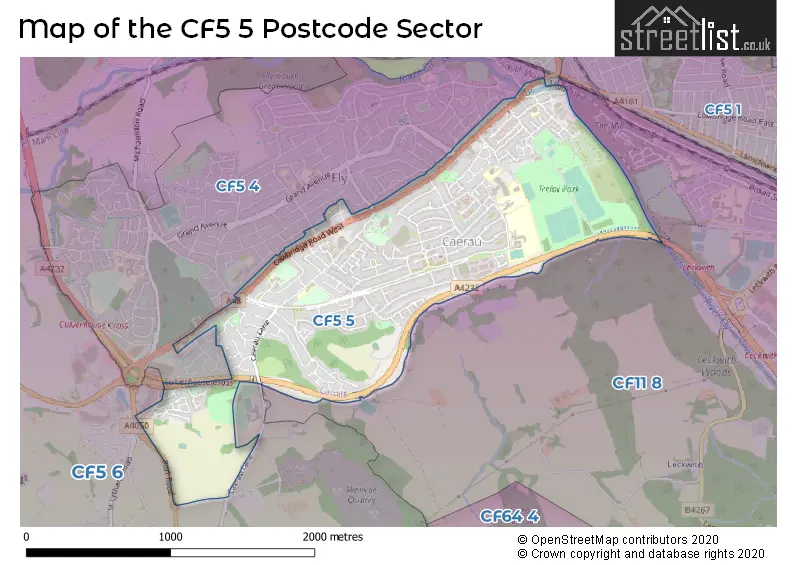
The CF5 5 Postcode shares a border with CF5 3 (FAIRWATER, CARDIFF, ST FAGANS), CF5 4 (CARDIFF, ELY, ST FAGANS), CF5 6 (ST FAGANS, WENVOE, CREIGIAU) and CF11 8 (CANTON, LECKWITH, CARDIFF).
The sector is within the post town of CARDIFF.
CF5 5 is a postcode sector within the CF5 postcode district which is within the CF Cardiff postcode area.
The Royal Mail delivery office for the CF5 5 postal sector is the Cardiff West Delivery Office.
The area of the CF5 5 postcode sector is 1.34 square miles which is 3.48 square kilometres or 859.77 square acres.

Map of the CF5 5 Postcode Sector
Explore the CF5 5 postcode sector by using our free interactive map.
| C | F | 5 | - | 5 | X | X |
| C | F | 5 | Space | 5 | Letter | Letter |
Official List of Streets
CARDIFF (109 Streets)
Ely (8 Streets)
Unofficial Streets or Alternative Spellings
CARDIFF
BRUNDALL CRESCENT CROSSWAYS ROAD FORGE PLACE GRAND AVENUE HIGHMEAD ROAD HOLLYCROFT CLOSE KNIGHTSWELL ROAD L�N YR EFAIL PARKER ROAD PENDINE ROAD TEIFI PLACE WILSON PLACE WILSON ROADCanton
THE BOULEVARDEly
MILL ROAD STATION TERRACE WROUGHTON PLACE ASH GROVE BAYLIS COURT BERKELEY SQUARE BROADFIELD COURT CLOS-Y-RHIW CWRT ROBERTS CWRT-YR-ALA AVENUE CWRT-YR-ALA ROAD GREEN FARM ROAD HEOL PANTYDERI HEOL-Y-BERLLAN HEOL-Y-CASTELL HEOL-Y-FELIN HEOL-Y-GAER HEOL-YR-ODYN HILL-SNOOK ROAD LON-Y-CASTELL LON-YR-EFAIL MAYFAIR PANT-Y-DERI CLOSE PARK AVENUE PORT ROAD CYCLEWAY QUEENS DRIVE REGENT AVENUE ST DAVIDS CRESCENT ST. MARYS CLOSE WINSTON AVENUEWenvoe
ALPS QUARRY ROAD PORT ROADWeather Forecast for CF5 5
Press Button to Show Forecast for Caerau
| Time Period | Icon | Description | Temperature | Rain Probability | Wind |
|---|---|---|---|---|---|
| 06:00 to 09:00 | Cloudy | 7.0°C (feels like 4.0°C) | 9.00% | ENE 9 mph | |
| 09:00 to 12:00 | Cloudy | 8.0°C (feels like 5.0°C) | 10.00% | E 11 mph | |
| 12:00 to 15:00 | Overcast | 10.0°C (feels like 7.0°C) | 15.00% | E 9 mph | |
| 15:00 to 18:00 | Overcast | 10.0°C (feels like 8.0°C) | 17.00% | E 9 mph | |
| 18:00 to 21:00 | Cloudy | 10.0°C (feels like 8.0°C) | 15.00% | E 9 mph | |
| 21:00 to 00:00 | Cloudy | 9.0°C (feels like 6.0°C) | 17.00% | E 9 mph |
Press Button to Show Forecast for Caerau
| Time Period | Icon | Description | Temperature | Rain Probability | Wind |
|---|---|---|---|---|---|
| 00:00 to 03:00 | Cloudy | 7.0°C (feels like 5.0°C) | 15.00% | ENE 9 mph | |
| 03:00 to 06:00 | Cloudy | 7.0°C (feels like 4.0°C) | 12.00% | ENE 11 mph | |
| 06:00 to 09:00 | Cloudy | 7.0°C (feels like 3.0°C) | 14.00% | NE 11 mph | |
| 09:00 to 12:00 | Cloudy | 8.0°C (feels like 4.0°C) | 22.00% | ENE 13 mph | |
| 12:00 to 15:00 | Cloudy | 10.0°C (feels like 7.0°C) | 18.00% | ENE 13 mph | |
| 15:00 to 18:00 | Cloudy | 11.0°C (feels like 8.0°C) | 15.00% | NE 13 mph | |
| 18:00 to 21:00 | Cloudy | 10.0°C (feels like 8.0°C) | 17.00% | NE 13 mph | |
| 21:00 to 00:00 | Light rain | 9.0°C (feels like 7.0°C) | 49.00% | NE 13 mph |
Press Button to Show Forecast for Caerau
| Time Period | Icon | Description | Temperature | Rain Probability | Wind |
|---|---|---|---|---|---|
| 00:00 to 03:00 | Light rain | 9.0°C (feels like 6.0°C) | 46.00% | NE 13 mph | |
| 03:00 to 06:00 | Light rain | 8.0°C (feels like 5.0°C) | 53.00% | NE 11 mph | |
| 06:00 to 09:00 | Light rain | 8.0°C (feels like 5.0°C) | 52.00% | NE 11 mph | |
| 09:00 to 12:00 | Light rain | 9.0°C (feels like 7.0°C) | 45.00% | NE 11 mph | |
| 12:00 to 15:00 | Heavy rain shower (day) | 11.0°C (feels like 9.0°C) | 56.00% | NW 11 mph | |
| 15:00 to 18:00 | Heavy rain shower (day) | 12.0°C (feels like 10.0°C) | 54.00% | NNW 11 mph | |
| 18:00 to 21:00 | Partly cloudy (day) | 11.0°C (feels like 9.0°C) | 10.00% | NNW 11 mph | |
| 21:00 to 00:00 | Clear night | 10.0°C (feels like 8.0°C) | 4.00% | N 9 mph |
House Prices in the CF5 5 Postcode Sector
| Type of Property | 2018 Average | 2018 Sales | 2017 Average | 2017 Sales | 2016 Average | 2016 Sales | 2015 Average | 2015 Sales |
|---|---|---|---|---|---|---|---|---|
| Detached | £223,104 | 14 | £235,064 | 14 | £223,295 | 10 | £202,133 | 15 |
| Semi-Detached | £164,115 | 50 | £146,261 | 59 | £146,032 | 59 | £135,287 | 55 |
| Terraced | £132,748 | 49 | £131,421 | 50 | £129,314 | 62 | £120,144 | 46 |
| Flats | £87,500 | 12 | £86,131 | 21 | £85,322 | 27 | £74,732 | 17 |
Important Postcodes CF5 5 in the Postcode Sector
CF5 5AL is the postcode for Millbank Primary School, Clarke Street
CF5 5AQ is the postcode for Riverbank Special School, Vincent Road, Ty Storrie Respite Centre, Vincent Road, Ty Gwyn Special School, Vincent Road, and Woodlands High Special School, Vincent Road
CF5 5BQ is the postcode for Ely & Caerau Hub, Cowbridge Road West, Ely And Caerau Hub, Cowbridge Road West, Caerau, Jasmine Enterprise Centre, Cowbridge Road West, and South Wales Fire & Rescue Service, Fire Station, Cowbridge Road West
CF5 5BT is the postcode for Pendine Centre, 124-126 Cowbridge Road West
CF5 5DY is the postcode for Trelai Youth Centre, Bishopston Road, and Trelai Primary School, Bishopston Road
CF5 5HJ is the postcode for Western Leisure Centre, Caerau Lane
CF5 5NU is the postcode for Park View Health Centre, Treseder Way
CF5 5QN is the postcode for Cwrt-yr-Ala Junior School, Cyntwell Avenue, and Pencaerau Primary School, Cyntwell Avenue
CF5 5QZ is the postcode for Caerau Infant School, Caerau Lane, SPORTS HALL (BLOCK 3), Mary Immaculate High School, Caerau Lane, MAIN BUILDING (BLOCK 1 AND 2), Mary Immaculate High School, Caerau Lane, Ysgol Nant Caerau, Caerau Lane, and Mary Immaculate High School, Caerau Lane
CF5 5XP is the postcode for Glyn Derw High School, Penally Road
| The CF5 5 Sector is within these Local Authorities |
|
|---|---|
| The CF5 5 Sector is within these Counties |
|
| The CF5 5 Sector is within these Water Company Areas |
|