The CH46 9 postcode sector is within the county of Merseyside.
Did you know? According to the 2021 Census, the CH46 9 postcode sector is home to a bustling 2,745 residents!
Given that each sector allows for 400 unique postcode combinations. Letters C, I, K, M, O and V are not allowed in the last two letters of a postcode. With 70 postcodes already in use, this leaves 330 units available.
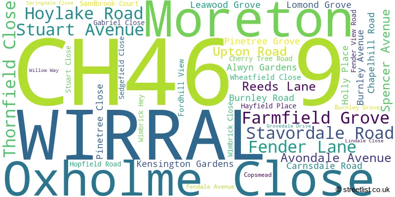
The largest settlements in the CH46 9 postal code are WIRRAL and Moreton.
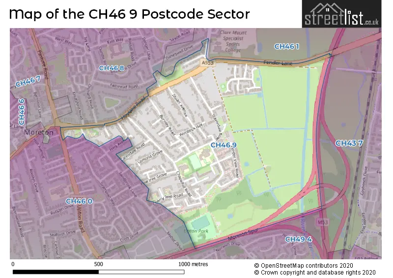
The CH46 9 Postcode shares a border with CH43 7 (PRENTON), CH49 4 (WIRRAL, Upton), CH46 0 (WIRRAL, Moreton), CH46 1 (WIRRAL, Moreton) and CH46 8 (WIRRAL, Moreton).
The sector is within the post town of WIRRAL.
CH46 9 is a postcode sector within the CH46 postcode district which is within the CH Chester postcode area.
The Royal Mail delivery office for the CH46 9 postal sector is the Moreton Delivery Office.
The area of the CH46 9 postcode sector is 0.40 square miles which is 1.04 square kilometres or 257.83 square acres.
The CH46 9 postcode sector is crossed by the M53 motorway.

Map of the CH46 9 Postcode Sector
Explore the CH46 9 postcode sector by using our free interactive map.
| C | H | 4 | 6 | - | 9 | X | X |
| C | H | 4 | 6 | Space | 9 | Letter | Letter |
Official List of Streets
WIRRAL (33 Streets)
Unofficial Streets or Alternative Spellings
Weather Forecast for CH46 9
Press Button to Show Forecast for Moreton
| Time Period | Icon | Description | Temperature | Rain Probability | Wind |
|---|---|---|---|---|---|
| 03:00 to 06:00 | Partly cloudy (night) | 6.0°C (feels like 3.0°C) | 2.00% | ESE 7 mph | |
| 06:00 to 09:00 | Partly cloudy (day) | 5.0°C (feels like 3.0°C) | 1.00% | ESE 7 mph | |
| 09:00 to 12:00 | Partly cloudy (day) | 8.0°C (feels like 6.0°C) | 2.00% | E 7 mph | |
| 12:00 to 15:00 | Overcast | 9.0°C (feels like 7.0°C) | 9.00% | NE 7 mph | |
| 15:00 to 18:00 | Overcast | 10.0°C (feels like 8.0°C) | 10.00% | NNE 7 mph | |
| 18:00 to 21:00 | Cloudy | 9.0°C (feels like 7.0°C) | 7.00% | NNE 9 mph | |
| 21:00 to 00:00 | Cloudy | 8.0°C (feels like 6.0°C) | 7.00% | ENE 9 mph |
Press Button to Show Forecast for Moreton
| Time Period | Icon | Description | Temperature | Rain Probability | Wind |
|---|---|---|---|---|---|
| 00:00 to 03:00 | Cloudy | 7.0°C (feels like 4.0°C) | 8.00% | E 9 mph | |
| 03:00 to 06:00 | Cloudy | 5.0°C (feels like 3.0°C) | 9.00% | ESE 7 mph | |
| 06:00 to 09:00 | Cloudy | 6.0°C (feels like 3.0°C) | 8.00% | E 9 mph | |
| 09:00 to 12:00 | Cloudy | 8.0°C (feels like 6.0°C) | 10.00% | E 9 mph | |
| 12:00 to 15:00 | Overcast | 10.0°C (feels like 8.0°C) | 15.00% | ENE 9 mph | |
| 15:00 to 18:00 | Overcast | 10.0°C (feels like 8.0°C) | 18.00% | NE 11 mph | |
| 18:00 to 21:00 | Cloudy | 10.0°C (feels like 8.0°C) | 14.00% | NE 11 mph | |
| 21:00 to 00:00 | Cloudy | 9.0°C (feels like 6.0°C) | 15.00% | NE 11 mph |
Press Button to Show Forecast for Moreton
| Time Period | Icon | Description | Temperature | Rain Probability | Wind |
|---|---|---|---|---|---|
| 00:00 to 03:00 | Cloudy | 8.0°C (feels like 5.0°C) | 18.00% | NE 11 mph | |
| 03:00 to 06:00 | Cloudy | 8.0°C (feels like 5.0°C) | 18.00% | NE 11 mph | |
| 06:00 to 09:00 | Heavy rain | 8.0°C (feels like 5.0°C) | 68.00% | NE 11 mph | |
| 09:00 to 12:00 | Overcast | 9.0°C (feels like 6.0°C) | 23.00% | NNE 11 mph | |
| 12:00 to 15:00 | Light rain | 10.0°C (feels like 8.0°C) | 48.00% | NNE 13 mph | |
| 15:00 to 18:00 | Light rain shower (day) | 10.0°C (feels like 8.0°C) | 47.00% | N 13 mph | |
| 18:00 to 21:00 | Sunny day | 10.0°C (feels like 8.0°C) | 14.00% | WNW 13 mph | |
| 21:00 to 00:00 | Clear night | 9.0°C (feels like 7.0°C) | 9.00% | WNW 11 mph |
Schools and Places of Education Within the CH46 9 Postcode Sector
Orrets Meadow School
Community special school
Chapelhill Road, Wirral, Merseyside, CH46 9QQ
Head: Mrs Carolyn Duncan
Ofsted Rating: Outstanding
Inspection: 2017-10-11 (2389 days ago)
Website: Visit Orrets Meadow School Website
Phone: 01516788070
Number of Pupils: 82
House Prices in the CH46 9 Postcode Sector
| Type of Property | 2018 Average | 2018 Sales | 2017 Average | 2017 Sales | 2016 Average | 2016 Sales | 2015 Average | 2015 Sales |
|---|---|---|---|---|---|---|---|---|
| Detached | £181,400 | 10 | £170,113 | 8 | £176,582 | 11 | £141,177 | 11 |
| Semi-Detached | £139,406 | 16 | £133,500 | 12 | £126,800 | 12 | £123,145 | 10 |
| Terraced | £113,000 | 8 | £110,749 | 8 | £110,406 | 9 | £105,063 | 15 |
| Flats | £66,667 | 3 | £69,250 | 2 | £61,100 | 5 | £63,429 | 7 |
Important Postcodes CH46 9 in the Postcode Sector
CH46 9PA is the postcode for Clare Mount School, Fender Lane
CH46 9PS is the postcode for Sandbrook Primary School, Stavordale Road
| The CH46 9 Sector is within these Local Authorities |
|
|---|---|
| The CH46 9 Sector is within these Counties |
|
| The CH46 9 Sector is within these Water Company Areas |
|