The CH48 9 postcode sector is within the county of Merseyside.
Did you know? According to the 2021 Census, the CH48 9 postcode sector is home to a bustling 1,897 residents!
Given that each sector allows for 400 unique postcode combinations. Letters C, I, K, M, O and V are not allowed in the last two letters of a postcode. With 47 postcodes already in use, this leaves 353 units available.
The largest settlements in the CH48 9 postal code are WIRRAL and West Kirby.
The CH48 9 Postcode shares a border with CH48 6 (WIRRAL, West Kirby), CH48 8 (WIRRAL, West Kirby) and CH48 1 (WIRRAL, West Kirby, Frankby).
The sector is within the post town of WIRRAL.
CH48 9 is a postcode sector within the CH48 postcode district which is within the CH Chester postcode area.
The Royal Mail delivery office for the CH48 9 postal sector is the Hoylake Delivery Office.
The area of the CH48 9 postcode sector is 0.19 square miles which is 0.49 square kilometres or 121.28 square acres.

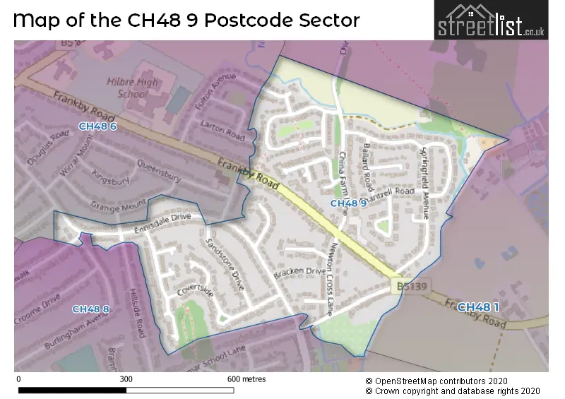
Map of the CH48 9 Postcode Sector
Explore the CH48 9 postcode sector by using our free interactive map.
| C | H | 4 | 8 | - | 9 | X | X |
| C | H | 4 | 8 | Space | 9 | Letter | Letter |
Official List of Streets
WIRRAL (24 Streets)
West Kirby (3 Streets)
Unofficial Streets or Alternative Spellings
WIRRAL
BURLINGHAM AVENUE FRANKBY STILES FULTON AVENUE GRAMMAR SCHOOL LANE LARTON ROADWest Kirby
HILLSIDE ROAD WOODLAND ROADFrankby
FRANKBY ROAD KINGSWALKWeather Forecast for CH48 9
Press Button to Show Forecast for West Kirby
| Time Period | Icon | Description | Temperature | Rain Probability | Wind |
|---|---|---|---|---|---|
| 12:00 to 15:00 | Cloudy | 21.0°C (feels like 18.0°C) | 3.00% | SE 11 mph | |
| 15:00 to 18:00 | Cloudy | 22.0°C (feels like 20.0°C) | 4.00% | SE 11 mph | |
| 18:00 to 21:00 | Cloudy | 22.0°C (feels like 20.0°C) | 4.00% | SE 11 mph | |
| 21:00 to 00:00 | Cloudy | 19.0°C (feels like 17.0°C) | 4.00% | SE 11 mph |
Press Button to Show Forecast for West Kirby
| Time Period | Icon | Description | Temperature | Rain Probability | Wind |
|---|---|---|---|---|---|
| 00:00 to 03:00 | Cloudy | 17.0°C (feels like 15.0°C) | 4.00% | SE 13 mph | |
| 03:00 to 06:00 | Cloudy | 15.0°C (feels like 13.0°C) | 3.00% | SE 11 mph | |
| 06:00 to 09:00 | Cloudy | 14.0°C (feels like 12.0°C) | 3.00% | SE 11 mph | |
| 09:00 to 12:00 | Cloudy | 17.0°C (feels like 15.0°C) | 4.00% | SE 13 mph | |
| 12:00 to 15:00 | Cloudy | 20.0°C (feels like 18.0°C) | 5.00% | SE 13 mph | |
| 15:00 to 18:00 | Cloudy | 22.0°C (feels like 19.0°C) | 16.00% | SSE 11 mph | |
| 18:00 to 21:00 | Light rain shower (day) | 18.0°C (feels like 17.0°C) | 46.00% | WSW 7 mph | |
| 21:00 to 00:00 | Cloudy | 16.0°C (feels like 15.0°C) | 21.00% | S 7 mph |
Press Button to Show Forecast for West Kirby
| Time Period | Icon | Description | Temperature | Rain Probability | Wind |
|---|---|---|---|---|---|
| 00:00 to 03:00 | Cloudy | 14.0°C (feels like 14.0°C) | 16.00% | SSE 7 mph | |
| 03:00 to 06:00 | Cloudy | 13.0°C (feels like 13.0°C) | 30.00% | SW 4 mph | |
| 06:00 to 09:00 | Cloudy | 13.0°C (feels like 13.0°C) | 8.00% | ESE 7 mph | |
| 09:00 to 12:00 | Cloudy | 15.0°C (feels like 13.0°C) | 11.00% | SSE 13 mph | |
| 12:00 to 15:00 | Cloudy | 16.0°C (feels like 13.0°C) | 20.00% | SE 16 mph | |
| 15:00 to 18:00 | Cloudy | 16.0°C (feels like 13.0°C) | 22.00% | SE 16 mph | |
| 18:00 to 21:00 | Heavy rain | 15.0°C (feels like 12.0°C) | 79.00% | SE 16 mph | |
| 21:00 to 00:00 | Heavy rain | 14.0°C (feels like 12.0°C) | 81.00% | SE 13 mph |
Press Button to Show Forecast for West Kirby
| Time Period | Icon | Description | Temperature | Rain Probability | Wind |
|---|---|---|---|---|---|
| 00:00 to 03:00 | Heavy rain | 14.0°C (feels like 12.0°C) | 77.00% | SSE 13 mph | |
| 03:00 to 06:00 | Light rain | 13.0°C (feels like 12.0°C) | 50.00% | SE 11 mph | |
| 06:00 to 09:00 | Cloudy | 13.0°C (feels like 11.0°C) | 16.00% | SSE 11 mph | |
| 09:00 to 12:00 | Cloudy | 14.0°C (feels like 12.0°C) | 16.00% | SSE 13 mph | |
| 12:00 to 15:00 | Partly cloudy (day) | 16.0°C (feels like 13.0°C) | 18.00% | SSE 13 mph | |
| 15:00 to 18:00 | Light rain shower (day) | 16.0°C (feels like 13.0°C) | 37.00% | SSW 13 mph | |
| 18:00 to 21:00 | Partly cloudy (day) | 15.0°C (feels like 13.0°C) | 19.00% | SE 13 mph | |
| 21:00 to 00:00 | Partly cloudy (night) | 14.0°C (feels like 11.0°C) | 8.00% | S 13 mph |
Press Button to Show Forecast for West Kirby
| Time Period | Icon | Description | Temperature | Rain Probability | Wind |
|---|---|---|---|---|---|
| 00:00 to 03:00 | Partly cloudy (night) | 13.0°C (feels like 10.0°C) | 5.00% | SSE 13 mph | |
| 03:00 to 06:00 | Cloudy | 12.0°C (feels like 9.0°C) | 8.00% | SSE 13 mph | |
| 06:00 to 09:00 | Partly cloudy (day) | 12.0°C (feels like 10.0°C) | 5.00% | SSE 16 mph | |
| 09:00 to 12:00 | Partly cloudy (day) | 14.0°C (feels like 11.0°C) | 12.00% | SSE 16 mph | |
| 12:00 to 15:00 | Partly cloudy (day) | 16.0°C (feels like 13.0°C) | 13.00% | SSE 13 mph | |
| 15:00 to 18:00 | Light rain shower (day) | 16.0°C (feels like 13.0°C) | 39.00% | SSE 13 mph | |
| 18:00 to 21:00 | Light rain shower (day) | 15.0°C (feels like 13.0°C) | 35.00% | S 11 mph | |
| 21:00 to 00:00 | Partly cloudy (night) | 13.0°C (feels like 11.0°C) | 4.00% | SSE 11 mph |
House Prices in the CH48 9 Postcode Sector
| Type of Property | 2018 Average | 2018 Sales | 2017 Average | 2017 Sales | 2016 Average | 2016 Sales | 2015 Average | 2015 Sales |
|---|---|---|---|---|---|---|---|---|
| Detached | £345,392 | 12 | £352,498 | 21 | £285,900 | 10 | £287,324 | 17 |
| Semi-Detached | £216,529 | 17 | £211,000 | 14 | £223,472 | 18 | £199,684 | 16 |
| Terraced | £179,667 | 3 | £196,650 | 3 | £207,000 | 2 | £182,500 | 2 |
| Flats | £122,908 | 6 | £115,000 | 1 | £123,875 | 4 | £115,000 | 1 |
| The CH48 9 Sector is within these Local Authorities |
|
|---|---|
| The CH48 9 Sector is within these Counties |
|
| The CH48 9 Sector is within these Water Company Areas |
|