The CH61 0 postcode sector is within the county of Merseyside.
Did you know? According to the 2021 Census, the CH61 0 postcode sector is home to a bustling 512 residents!
Given that each sector allows for 400 unique postcode combinations. Letters C, I, K, M, O and V are not allowed in the last two letters of a postcode. With 14 postcodes already in use, this leaves 386 units available.
The largest settlement in the CH61 0 postal code is Thurstaston followed by Irby, and WIRRAL.
The CH61 0 Postcode shares a border with CH61 2 (WIRRAL, Irby), CH60 6 (WIRRAL, Heswall), CH61 3 (WIRRAL, Irby, Thingwall), CH61 4 (WIRRAL, Irby), CH48 1 (WIRRAL, West Kirby, Frankby) and CH60 9 (Heswall, WIRRAL).
The sector is within the post town of WIRRAL.
CH61 0 is a postcode sector within the CH6 postcode district which is within the CH Chester postcode area.
The Royal Mail delivery office for the CH61 0 postal sector is the unknown.
The area of the CH61 0 postcode sector is 1.32 square miles which is 3.42 square kilometres or 844.09 square acres.

Map of the CH61 0 Postcode Sector
Explore the CH61 0 postcode sector by using our free interactive map.
| C | H | 6 | 1 | - | 0 | X | X |
| C | H | 6 | 1 | Space | 0 | Letter | Letter |
Official List of Streets
Thurstaston (5 Streets)
Heswall (1 Streets)
WIRRAL (1 Streets)
Irby (2 Streets)
Unofficial Streets or Alternative Spellings
Irby
SOUTH DRIVEWIRRAL
GREENHEYS ROAD HILLVIEW ROADHeswall
TELEGRAPH ROAD CHURCH ROAD FRANK LEWIS CYCLEWAY WIRRAL WAY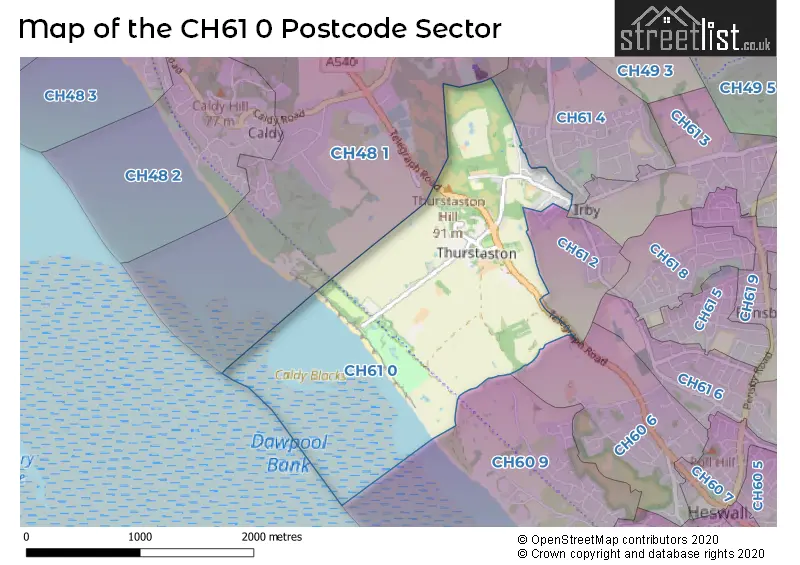
House Prices in the CH61 0 Postcode Sector
| Type of Property | 2018 Average | 2018 Sales | 2017 Average | 2017 Sales | 2016 Average | 2016 Sales | 2015 Average | 2015 Sales |
|---|---|---|---|---|---|---|---|---|
| Detached | £508,500 | 5 | £475,000 | 2 | £281,500 | 2 | £728,300 | 5 |
| Semi-Detached | £250,000 | 1 | £399,950 | 1 | £213,000 | 1 | £215,000 | 1 |
| Terraced | £280,000 | 1 | £0 | 0 | £495,000 | 1 | £0 | 0 |
| Flats | £180,000 | 1 | £0 | 0 | £0 | 0 | £307,000 | 1 |
Important Postcodes CH61 0 in the Postcode Sector
CH61 0HH is the postcode for Dawpool C of E Primary School, 6 School Lane
| The CH61 0 Sector is within these Local Authorities |
|
|---|---|
| The CH61 0 Sector is within these Counties |
|
| The CH61 0 Sector is within these Water Company Areas |
|