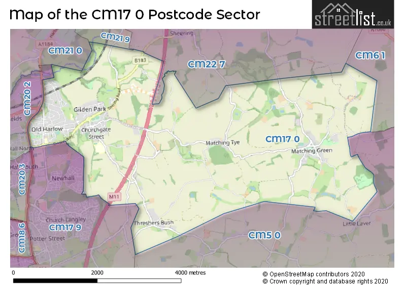
The CM17 0 postcode sector stands on the Essex and Hertfordshire border.
Did you know? According to the 2021 Census, the CM17 0 postcode sector is home to a bustling 8,916 residents!
Given that each sector allows for 400 unique postcode combinations. Letters C, I, K, M, O and V are not allowed in the last two letters of a postcode. With 230 postcodes already in use, this leaves 170 units available.
The largest settlement in the CM17 0 postal code is HARLOW followed by Matching Green, and Matching Tye.
The CM17 0 Postcode shares a border with CM20 2 (HARLOW, Gilston, Eastwick), CM20 3 (HARLOW), CM21 0 (SAWBRIDGEWORTH, High Wych, Allens Green), CM5 0 (ONGAR, Fyfield, Willingale), CM6 1 (DUNMOW, Little Canfield, Barnston), CM22 7 (Hatfield Heath, Little Hallingbury, Hatfield Broad Oak), CM17 9 (HARLOW, Newhall, Church Langley) and CM21 9 (SAWBRIDGEWORTH).
The sector is within the post town of HARLOW.
CM17 0 is a postcode sector within the CM17 postcode district which is within the CM Chelmsford postcode area.
The Royal Mail delivery office for the CM17 0 postal sector is the Harlow Delivery Office.
The area of the CM17 0 postcode sector is 9.63 square miles which is 24.95 square kilometres or 6,165.65 square acres.
The CM17 0 postcode sector is crossed by the M11 motorway.
Waterways within the CM17 0 postcode sector include the Feakes Lock, Stort Navigation.

Map of the CM17 0 Postcode Sector
Explore the CM17 0 postcode sector by using our free interactive map.
| C | M | 1 | 7 | - | 0 | X | X |
| C | M | 1 | 7 | Space | 0 | Letter | Letter |
Official List of Streets
HARLOW (106 Streets)
Matching (1 Streets)
Matching Green (9 Streets)
Matching Tye (6 Streets)
Threshers Bush (2 Streets)
Unofficial Streets or Alternative Spellings
Abbess Roding
ANCHOR LANESheering
HARLOW ROAD HIGH LANEHARLOW
CAMBRIDGE ROAD CHURCH MILL GRANGE FIRST AVENUE FOSTER STREET SHEERING HALL DRIVE ST. JOHNS AVENUE THE ROBINSNewhall
BARNSLEY WOOD RISE BLACKCAP DRIVE MAGPIE ROADHigh Laver
FAGGOTTERS LANEHARLOW,
SHEERING LOWER ROADWeather Forecast for CM17 0
Press Button to Show Forecast for Hatfield Heath
| Time Period | Icon | Description | Temperature | Rain Probability | Wind |
|---|---|---|---|---|---|
| 09:00 to 12:00 | Cloudy | 7.0°C (feels like 5.0°C) | 4.00% | ENE 7 mph | |
| 12:00 to 15:00 | Overcast | 10.0°C (feels like 8.0°C) | 9.00% | E 7 mph | |
| 15:00 to 18:00 | Overcast | 10.0°C (feels like 8.0°C) | 13.00% | E 7 mph | |
| 18:00 to 21:00 | Overcast | 8.0°C (feels like 6.0°C) | 15.00% | E 9 mph | |
| 21:00 to 00:00 | Cloudy | 6.0°C (feels like 4.0°C) | 10.00% | E 7 mph |
Press Button to Show Forecast for Hatfield Heath
| Time Period | Icon | Description | Temperature | Rain Probability | Wind |
|---|---|---|---|---|---|
| 00:00 to 03:00 | Cloudy | 5.0°C (feels like 3.0°C) | 14.00% | ENE 7 mph | |
| 03:00 to 06:00 | Cloudy | 5.0°C (feels like 2.0°C) | 16.00% | ENE 7 mph | |
| 06:00 to 09:00 | Light rain | 6.0°C (feels like 3.0°C) | 50.00% | ENE 9 mph | |
| 09:00 to 12:00 | Overcast | 9.0°C (feels like 6.0°C) | 20.00% | E 11 mph | |
| 12:00 to 15:00 | Cloudy | 11.0°C (feels like 9.0°C) | 20.00% | E 11 mph | |
| 15:00 to 18:00 | Light rain shower (day) | 12.0°C (feels like 9.0°C) | 38.00% | E 11 mph | |
| 18:00 to 21:00 | Light rain | 11.0°C (feels like 8.0°C) | 49.00% | E 11 mph | |
| 21:00 to 00:00 | Light rain | 9.0°C (feels like 6.0°C) | 47.00% | ENE 9 mph |
Press Button to Show Forecast for Hatfield Heath
| Time Period | Icon | Description | Temperature | Rain Probability | Wind |
|---|---|---|---|---|---|
| 00:00 to 03:00 | Cloudy | 9.0°C (feels like 6.0°C) | 24.00% | ENE 9 mph | |
| 03:00 to 06:00 | Light rain | 9.0°C (feels like 6.0°C) | 53.00% | E 9 mph | |
| 06:00 to 09:00 | Light rain | 9.0°C (feels like 7.0°C) | 52.00% | ESE 9 mph | |
| 09:00 to 12:00 | Heavy rain shower (day) | 10.0°C (feels like 8.0°C) | 61.00% | SSE 9 mph | |
| 12:00 to 15:00 | Light rain shower (day) | 12.0°C (feels like 10.0°C) | 44.00% | S 11 mph | |
| 15:00 to 18:00 | Heavy rain shower (day) | 13.0°C (feels like 10.0°C) | 59.00% | SSW 11 mph | |
| 18:00 to 21:00 | Light rain shower (day) | 12.0°C (feels like 10.0°C) | 32.00% | SSW 9 mph | |
| 21:00 to 00:00 | Clear night | 9.0°C (feels like 7.0°C) | 5.00% | S 9 mph |
Schools and Places of Education Within the CM17 0 Postcode Sector
Churchgate Church of England Voluntary Aided Primary School, Harlow
Voluntary aided school
Hobbs Cross Road, Harlow, Essex, CM17 0LB
Head: Mr Jonathan Tye
Ofsted Rating: Good
Inspection: 2019-02-28 (1884 days ago)
Website: Visit Churchgate Church of England Voluntary Aided Primary School, Harlow Website
Phone: 01279866059
Number of Pupils: 195
Fawbert and Barnard's Primary School
Academy converter
London Road, Old Harlow, Essex, CM17 0DA
Head: Mrs Sue Spearman
Ofsted Rating: Good
Inspection: 2022-02-02 (814 days ago)
Website: Visit Fawbert and Barnard's Primary School Website
Phone: 01279429427
Number of Pupils: 210
Harlowbury Primary School
Academy converter
Watlington Road, Harlow, Essex, CM17 0DX
Head: Ms Victoria Early
Ofsted Rating: Good
Inspection: 2022-03-16 (772 days ago)
Website: Visit Harlowbury Primary School Website
Phone: 01279423444
Number of Pupils: 201
Matching Green Church of England Voluntary Controlled Primary School
Voluntary controlled school
Little Laver Road, Harlow, Essex, CM17 0QB
Head: Miss Amy Wareham
Ofsted Rating: Good
Inspection: 2023-07-04 (297 days ago)
Website: Visit Matching Green Church of England Voluntary Controlled Primary School Website
Phone: 01279731225
Number of Pupils: 90
House Prices in the CM17 0 Postcode Sector
| Type of Property | 2018 Average | 2018 Sales | 2017 Average | 2017 Sales | 2016 Average | 2016 Sales | 2015 Average | 2015 Sales |
|---|---|---|---|---|---|---|---|---|
| Detached | £559,591 | 38 | £564,038 | 28 | £643,710 | 31 | £626,226 | 36 |
| Semi-Detached | £423,358 | 43 | £412,627 | 27 | £369,737 | 19 | £346,830 | 34 |
| Terraced | £350,261 | 40 | £309,329 | 29 | £306,915 | 30 | £265,703 | 45 |
| Flats | £228,144 | 17 | £216,083 | 12 | £204,588 | 15 | £177,582 | 17 |
Important Postcodes CM17 0 in the Postcode Sector
CM17 0AX is the postcode for Old Harlow Health Centre, Garden Terrace Road
CM17 0DA is the postcode for MAIN BUILDING, Fawbert & Barnards (Undl) Primary School, London Road, and HALL BUILDING, Fawbert & Barnards (Undl) Primary School, London Road
CM17 0DX is the postcode for Harlowbury Primary School, Watlington Road, and Harlowbury School, Watlington Road
CM17 0LB is the postcode for Churchgate C of E Primary School, Hobbs Cross Road, and MAIN BUILDING, Churchgate C of E Primary School, Hobbs Cross Road
CM17 0QB is the postcode for Matching Green C of E Primary School, Little Laver Road
| The CM17 0 Sector is within these Local Authorities |
|
|---|---|
| The CM17 0 Sector is within these Counties |
|
| The CM17 0 Sector is within these Water Company Areas |
|