CV47 2FH is a postal code used within the United Kingdom for delivering mail.
Postcodes are made up of two parts. The part before the space (CV47) is called the outward code. The part after the space (2FH) is called the inward code. The letters C, I, K, M, O and V are not allowed in the inward code. In addition to the inward and outward code, the postcode can be broken up into four parts:
- Postal Area. In our case CV which means Coventry.
- Postal District. In our case CV47.
- Postal Sector. In our case CV47 2.
- Postcode Unit. The last two letters. In our case FH.
The regional mail center for the post area CV is the National Distribution Centre, which is located at Danes Way, NORTHAMPTON, NN6 7DD.
The final port of call for any post addressed to the CV47 2FH postcode is the local delivery office (DO) which is SOUTHAM DO. Here the post will be sorted ready for delivery.
The properties in the CV47 2FH postcode have the street address of Bottom Street
A close-knit community! The 2021 Census indicates that only 6 individuals call the CV47 2FH postcode their home.
It is situated within the post town of SOUTHAM within the old postal county of Warwickshire.
CV47 2FH is within the village of Northend.
The CV47 2FH postcode area is composed of 100% residential properties, 0% commercial properties, and 0% public properties.
According to our data. Most dwellings in CV47 2FH are houses. Of these houses, most are end-terraced.
Most properties in CV47 2FH are owned by the occupiers with the rest being unknown tenure.
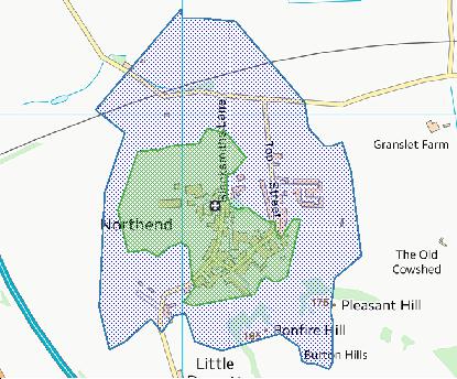
Interactive Mapping Showing UPRNs within the CV47 2FH Postcode Boundaries
Use the search box to search for other postcodes or places.
| Property Type | Percentage |
|---|---|
| Residential | 100% |
| Commercial | 0% |
| Public | 0% |
Map Coordinates for CV47 2FH
| Latitude | 52.1709484224 |
|---|---|
| Longitude | -1.4294365918 |
Weather Forecast for CV47 2FH
Mon 6th May
Press Button to Show Forecast for Bishop's Itchington
| Time Period | Icon | Description | Temperature | Rain Probability | Wind |
|---|---|---|---|---|---|
| 00:00 to 03:00 | Overcast | 10.0°C (feels like 9.0°C) | 10.00% | SSE 4 mph | |
| 03:00 to 06:00 | Cloudy | 10.0°C (feels like 10.0°C) | 6.00% | S 2 mph | |
| 06:00 to 09:00 | Mist | 10.0°C (feels like 10.0°C) | 14.00% | SW 2 mph | |
| 09:00 to 12:00 | Cloudy | 13.0°C (feels like 13.0°C) | 8.00% | NW 4 mph | |
| 12:00 to 15:00 | Partly cloudy (day) | 16.0°C (feels like 16.0°C) | 30.00% | NNE 4 mph | |
| 15:00 to 18:00 | Cloudy | 17.0°C (feels like 16.0°C) | 16.00% | N 7 mph | |
| 18:00 to 21:00 | Cloudy | 15.0°C (feels like 15.0°C) | 32.00% | N 7 mph | |
| 21:00 to 00:00 | Cloudy | 13.0°C (feels like 12.0°C) | 6.00% | NNW 4 mph |
Tue 7th May
Press Button to Show Forecast for Bishop's Itchington
| Time Period | Icon | Description | Temperature | Rain Probability | Wind |
|---|---|---|---|---|---|
| 00:00 to 03:00 | Clear night | 11.0°C (feels like 9.0°C) | 1.00% | NNW 7 mph | |
| 03:00 to 06:00 | Partly cloudy (night) | 10.0°C (feels like 9.0°C) | 2.00% | NNW 7 mph | |
| 06:00 to 09:00 | Cloudy | 11.0°C (feels like 9.0°C) | 6.00% | N 7 mph | |
| 09:00 to 12:00 | Cloudy | 13.0°C (feels like 12.0°C) | 7.00% | N 7 mph | |
| 12:00 to 15:00 | Cloudy | 16.0°C (feels like 15.0°C) | 9.00% | N 7 mph | |
| 15:00 to 18:00 | Cloudy | 17.0°C (feels like 16.0°C) | 9.00% | N 7 mph | |
| 18:00 to 21:00 | Partly cloudy (day) | 16.0°C (feels like 15.0°C) | 5.00% | NNE 7 mph | |
| 21:00 to 00:00 | Clear night | 12.0°C (feels like 11.0°C) | 1.00% | NE 7 mph |
Wed 8th May
Press Button to Show Forecast for Bishop's Itchington
| Time Period | Icon | Description | Temperature | Rain Probability | Wind |
|---|---|---|---|---|---|
| 00:00 to 03:00 | Clear night | 9.0°C (feels like 8.0°C) | 2.00% | ENE 4 mph | |
| 03:00 to 06:00 | Cloudy | 8.0°C (feels like 8.0°C) | 5.00% | ENE 4 mph | |
| 06:00 to 09:00 | Cloudy | 9.0°C (feels like 9.0°C) | 5.00% | ENE 4 mph | |
| 09:00 to 12:00 | Cloudy | 12.0°C (feels like 12.0°C) | 4.00% | ENE 4 mph | |
| 12:00 to 15:00 | Cloudy | 16.0°C (feels like 15.0°C) | 4.00% | NE 4 mph | |
| 15:00 to 18:00 | Cloudy | 17.0°C (feels like 17.0°C) | 4.00% | WNW 4 mph | |
| 18:00 to 21:00 | Cloudy | 17.0°C (feels like 17.0°C) | 4.00% | SE 4 mph | |
| 21:00 to 00:00 | Cloudy | 13.0°C (feels like 12.0°C) | 3.00% | SSE 7 mph |
Thu 9th May
Press Button to Show Forecast for Bishop's Itchington
| Time Period | Icon | Description | Temperature | Rain Probability | Wind |
|---|---|---|---|---|---|
| 00:00 to 03:00 | Cloudy | 11.0°C (feels like 10.0°C) | 3.00% | S 7 mph | |
| 03:00 to 06:00 | Cloudy | 9.0°C (feels like 8.0°C) | 4.00% | S 4 mph | |
| 06:00 to 09:00 | Cloudy | 10.0°C (feels like 10.0°C) | 4.00% | SSW 4 mph | |
| 09:00 to 12:00 | Cloudy | 15.0°C (feels like 15.0°C) | 4.00% | SSW 4 mph | |
| 12:00 to 15:00 | Cloudy | 18.0°C (feels like 17.0°C) | 4.00% | SSW 4 mph | |
| 15:00 to 18:00 | Cloudy | 19.0°C (feels like 18.0°C) | 4.00% | SSW 4 mph | |
| 18:00 to 21:00 | Cloudy | 18.0°C (feels like 18.0°C) | 5.00% | SSW 4 mph | |
| 21:00 to 00:00 | Cloudy | 13.0°C (feels like 13.0°C) | 4.00% | S 4 mph |
Schools within a five minute drive of CV47 2FH Postcode
England Primary Schools
Temple Herdewyke Primary School
Address: Temple Herdewyke Primary School, Falkland Place, Temple Herdewyke, Southam, Warwickshire, CV47 2UD
Distance: 0.71 miles
Contact:
Nearest Dentists
Dentists near CV47 2FH
KINETON DENTAL CENTRE
Address: MARLBOROUGH, TEMPLE HERDEWYKE, SOUTHAM, WARWICKSHIRE, CV47 2UL
Distance: 0.77 miles
Contact: :
BROOK HOUSE (DENTAL SURGERY)
Address: BROOK HOUSE, MORETON MORRELL, WARWICK, WARWICKSHIRE, CV35 9AR
Distance: 5.35 miles
Contact: :
CEDARLEA DENTAL CARE
Address: 12 WARWICK ROAD, SOUTHAM, WARWICKSHIRE, CV47 0HN
Distance: 5.71 miles
Contact: :
21 MARKET HILL [DENTAL PRACTICE
Address: 21 MARKET HILL, SOUTHAM, WARWICKSHIRE, CV47 0HF
Distance: 5.89 miles
Contact: :
DENTAL SURGERY
Address: 2 DAVENTRY STREET, SOUTHAM, WARWICKSHIRE, CV47 1PH
Distance: 5.95 miles
Contact: :
DENTAL SURGERY
Address: 2 WILLOW DRIVE, WELLESBOURNE, WARWICK, WARWICKSHIRE, CV35 9SB
Distance: 7.10 miles
Contact: :
Nearest Chemists
Pharmacies near CV47 2FH
KINETON PHARMACY
Address: WARWICK ROAD, KINETON, WARWICK, CV35 0HN
Distance: 3.63 miles
Contact: tel: 01926 641902
HARBURY PHARMACY
Address: HIGH STREET, HARBURY, LEAMINGTON SPA, WARWICKSHIRE, CV33 9HW
Distance: 4.67 miles
Contact: :
SOUTHAM PHARMACY
Address: 4 MARKET HILL, SOUTHAM, WARWICKSHIRE, CV47 0HE
Distance: 5.89 miles
Contact: tel: 01926 812287
OXFORD ONLINE PHARMACY
Address: UNIT 7, APOLLO OFFICE PARK, IRONSTONE LANE, BANBURY, OX15 6AY
Distance: 6.29 miles
Contact: tel: 01295 262925
WELLESBOURNE PHARMACY
Address: HASTINGS HOUSE MEDICAL CENTRE, RIVERS WAY, WELLESBOURNE, WARWICK, CV35 9RH
Distance: 7.18 miles
Contact: tel: 01789 840484
WELL
Address: HARDWICK SHOPPING CENTRE, FERRISTON, BANBURY, OXFORDSHIRE, OX16 1XE
Distance: 7.32 miles
Contact: tel: 01295 272432
Nearest Opticians
Opticians near CV47 2FH
KINETON OPTOMETRISTS
Address: THE BANK HOUSE, BANBURY STREET, KINETON, WARWICK, WARWICKSHIRE, CV35 0JS
Distance: 3.54 miles
Contact: :
JANET PORTER OPTICIANS
Address: 52 COVENTRY STREET, SOUTHAM, WARWICKSHIRE, CV47 0EP
Distance: 6.01 miles
Contact: :
M&S OPTICIANS - BANBURY
Address: UNIT 11, BANBURY GATEWAY, ACORN WAY, BANBURY, OX16 3AB
Distance: 8.07 miles
Contact: :
4660 LEAMINGTON SPA
Address: ASDA STORES LTD, CHESTERTON DRIVE, SYDENHAM, LEAMINGTON SPA, WARWICKSHIRE, CV31 1YD
Distance: 8.14 miles
Contact: :
VISION EXPRESS (BANBURY)
Address: UNIT 8, CASTLE QUAY, BANBURY, OXFORDSHIRE, OX16 5UH
Distance: 8.48 miles
Contact: :
BOOTS OPTICIANS (BANBURY)
Address: 19 CASTLE QUAY, BANBURY, OXFORDSHIRE, OX16 5UH
Distance: 8.48 miles
Contact: :
Nearest GP Surgeries
Doctors near CV47 2FH
FENNY COMPTON SURGERY - COVID LOCAL VACCINATION SERVICE
Address: HIGH STREET, FENNY COMPTON, SOUTHAM, CV47 2YG
Distance: 1.67 miles
Contact: :
FENNY COMPTON SURGERY
Address: THE SURGERY, HIGH STREET, FENNY COMPTON, SOUTHAM, WARWICKSHIRE, CV47 2YG
Distance: 1.67 miles
Contact: tel: 01295 770855
THE SURGERY
Address: FISHERS ROAD, BISHOPS ITCHINGTON, SOUTHAM, WARWICKSHIRE, CV47 2RE
Distance: 3.18 miles
Contact: tel: 01926 612977
VALE OF RED HORSE
Address: OLD SCHOOL, MARKET SQUARE, KINETON, WARWICK, WARWICKSHIRE, CV35 0LP
Distance: 3.54 miles
Contact: tel: 01926 640471
LITTLE THATCH
Address: WARWICK ROAD, KINETON, WARWICKSHIRE, CV35 0HN
Distance: 3.63 miles
Contact: tel: 01926 640491
HARBURY SURGERY
Address: MILL STREET, HARBURY, LEAMINGTON SPA, WARWICKSHIRE, CV33 9HR
Distance: 4.72 miles
Contact: tel: 01926 612232
Transport Links near CV47 2FH
Train Stations
Nearest stations for postcode: CV47 2FH
- Banbury
Banbury station, Station Road, Banbury, Oxfordshire, OX16 5ABDistance: 10.50 milesDriving Time: 18.08 minutes - Warwick
Warwick station, Station Approach, Warwick, Warwickshire, CV34 4LADistance: 12.52 milesDriving Time: 18.23 minutes - Leamington Spa
Leamington Spa station, Old Warwick Road, Leamington Spa, Warwickshire, CV31 3NSDistance: 12.56 milesDriving Time: 17.68 minutes - Warwick Parkway
Warwick Parkway station, Old Budbrooke Road, near Warwick, Warwickshire, CV35 8RHDistance: 14.58 milesDriving Time: 18.81 minutes - Kings Sutton
Kings Sutton station, Station Approach, Kings Sutton, Oxfordshire, OX17 3RRDistance: 14.72 milesDriving Time: 23.77 minutes
Distances represent the quickest route by car.
Motorway Junctions near CV47 2FH
Train Stations
Motorway Junctions near CV47 2FH
Distances represent the quickest route by car.
Who are my Elected Representatives in the CV47 2FH Postcode?
| Westminster Constituency | Kenilworth and Southam Co Const |
|---|---|
| Member or Parliament |  |
| Contact Details | Contact Jeremy Wright |
| Political Party | Conservative |
What Council is the CV47 2FH Postcode in?
The Local Council for this Postcode is Stratford-on-Avon District Council and the County Council is Warwickshire County Council.
Warwickshire County Council is responsible for providing education, libraries and maintaining highways.
Stratford-on-Avon District Council is responsible for duties such as council tax, rubbish collection, housing, environmental health and planning.
You can visit the website for Stratford-on-Avon District at the following link Stratford-on-Avon District.How much is the Council Tax?
Stratford-on-Avon District Council is responsible for collecting council tax. This will vary depending on which council tax band the property falls within. You can check the council tax band at the gov.uk website.
Once you know the council tax band you can view how much Stratford-on-Avon District charge for that band by visiting the The Council Tax section of their website.
Planning Applications
When moving house to a new post code it is worth checking out what will be built in the neighbourhood.
Few people want to live next door to a building site, have their garden overlooked or have the views from their property ruined.
Visit the local planning department and search for planning applications in this postcode granted within the last three years or still awaiting a decision. This will give an indication of what could still be built.
Where can I find out where the nearest Library to the CV47 2FH Postcode is?
Libraries are the responsibility of Warwickshire County Council
Visit the link for more information. Please note that some councils outsource library services to private companies and community groups ran by volunteers.
Libraries � Warwickshire County CouncilHouse Sales in CV47 2FH
| Year | High | Low | Average | Sales |
|---|---|---|---|---|
| 2021 | £237,000 | £237,000 | £237,000 | 1 |
Contains HM Land Registry data © Crown copyright and database right 2024. This data is licensed under the Open Government Licence v3.0.
Postcodes near the CV47 2FH Postcode
What Popular Supermarkets are near the CV47 2FH Postcode?
| Supermarket | Distance | Directions |
|---|---|---|
| Tesco, Northfield Road, Kineton Road Industrial Estate, SOUTHAM, CV47 0FG | 8.78 miles | Directions from CV47 2FH to Tesco |
| Iceland, Lockheed Close, BANBURY, OX16 1LX | 12.29 miles | Directions from CV47 2FH to Iceland |
| Aldi, Ruscote Avenue, BANBURY, OX16 2GU | 12.49 miles | Directions from CV47 2FH to Aldi |
| Asda, Chesterton Drive, LEAMINGTON SPA, CV31 1YD | 13.08 miles | Directions from CV47 2FH to Asda |
| Waitrose, Southam Road, BANBURY, OX16 2FW | 13.18 miles | Directions from CV47 2FH to Waitrose |
What Popular Restaurants are near the CV47 2FH Postcode?
| Burger King | Distance | Directions |
|---|---|---|
| Warwick (north) Service Area, Warwick, CV35 0AA | 4.49 miles | Directions from CV47 2FH to Warwick (north) Service Area |
| M40 Junction 12/13, Ashorne, CV35 0AA | 4.49 miles | Directions from CV47 2FH to M40 Junction 12/13 |
| Central Six Retail Park, Coventry, CV3 6TA | 16.36 miles | Directions from CV47 2FH to Central Six Retail Park |
| M40 Junction 10, Southbound, Bicester, OX27 7RD | 18.12 miles | Directions from CV47 2FH to M40 Junction 10, Southbound |
| Mcdonald's | Distance | Directions |
|---|---|---|
| McDonald's, Beaumont Road, BANBURY, OX16 1RH | 7.55 miles | Directions from CV47 2FH to McDonald's, Beaumont Road, BANBURY, OX16 1RH |
| McDonald's, Acorn Way, BANBURY, OX16 3AB | 8.05 miles | Directions from CV47 2FH to McDonald's, Acorn Way, BANBURY, OX16 3AB |
| McDonald's, Queensway, LEAMINGTON SPA, CV31 3JZ | 8.99 miles | Directions from CV47 2FH to McDonald's, Queensway, LEAMINGTON SPA, CV31 3JZ |
| McDonald's, Parade, LEAMINGTON SPA, CV32 4DN | 9.51 miles | Directions from CV47 2FH to McDonald's, Parade, LEAMINGTON SPA, CV32 4DN |
| Restaurant | Distance | Directions |
|---|---|---|
| KFC, Banbury Road, Ashorne, WARWICK, CV35 0AA | 4.49 miles | Directions from CV47 2FH to KFC Warwick - M40 North Services |
| KFC, Banbury Road, Ashorne, WARWICK, CV35 0AA | 4.49 miles | Directions from CV47 2FH to KFC Warwick - M40 South Services |
| KFC, Lockheed Close, BANBURY, OX16 1LX | 7.64 miles | Directions from CV47 2FH to KFC Banbury Cross Retail Park |
| KFC, Elliotts Field Shopping Park, Leicester Road, RUGBY, CV21 1SR | 16.61 miles | Directions from CV47 2FH to KFC Rugby - Leicester Road Retail Park |
| KFC, Walsgrave Road, COVENTRY, CV2 4BL | 16.68 miles | Directions from CV47 2FH to KFC Coventry - Walsgrave Road |