The CV5 7 postcode sector is within the county of West Midlands.
Did you know? According to the 2021 Census, the CV5 7 postcode sector is home to a bustling 12,038 residents!
Given that each sector allows for 400 unique postcode combinations. Letters C, I, K, M, O and V are not allowed in the last two letters of a postcode. With 223 postcodes already in use, this leaves 177 units available.
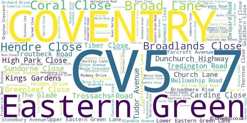
The CV5 7 postal code covers the settlement of COVENTRY.
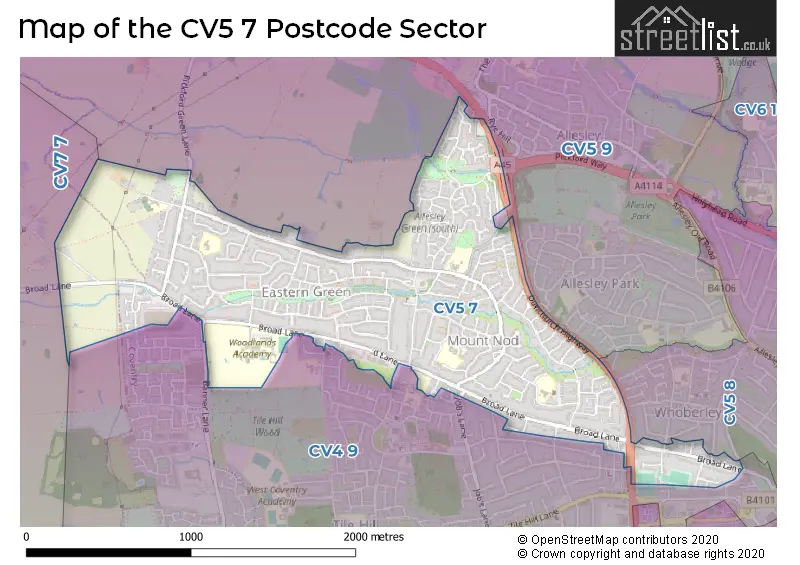
The CV5 7 Postcode shares a border with CV5 8 (COVENTRY), CV5 9 (COVENTRY, Allesley, Millisons Wood), CV4 9 (COVENTRY) and CV7 7 (Balsall Common, Meriden, Berkswell).
The sector is within the post town of COVENTRY.
CV5 7 is a postcode sector within the CV5 postcode district which is within the CV Coventry postcode area.
The Royal Mail delivery office for the CV5 7 postal sector is the Coventry City Delivery Office and Coventry West Delivery Office.
The area of the CV5 7 postcode sector is 1.33 square miles which is 3.43 square kilometres or 848.38 square acres.

Map of the CV5 7 Postcode Sector
Explore the CV5 7 postcode sector by using our free interactive map.
| C | V | 5 | - | 7 | X | X |
| C | V | 5 | Space | 7 | Letter | Letter |
Official List of Streets
COVENTRY (123 Streets)
Eastern Green (2 Streets)
Unofficial Streets or Alternative Spellings
COVENTRY
ASTORIA DRIVE BANNER LANE BAYCHESTER ROAD BEECH TREE AVENUE BUSH CLOSE FERNDOWN CLOSE FLETCHAMSTEAD HIGHWAY GLENDOWER AVENUE JARDINE CRESCENT LARCH TREE AVENUE THIRLMERE CLOSE WILDCROFT ROAD BROOKSTRAY FLATS CENTORA WALK DELTA CLOSE FORREST COURT GARDEN FLATS HAWTHORN LANE HOVE AVENUE JOBS LANE MADIN CLOSE OLTON ROAD PARK HILL LANE (PATH) ROSE COTTAGEAllesley
DUNCHURCH HIGHWAY PARK HILL LANE PICKFORD GREEN LANEMeriden
BACK LANEWeather Forecast for CV5 7
Press Button to Show Forecast for Upper Eastern Green
| Time Period | Icon | Description | Temperature | Rain Probability | Wind |
|---|---|---|---|---|---|
| 03:00 to 06:00 | Cloudy | 3.0°C (feels like 1.0°C) | 6.00% | ENE 4 mph | |
| 06:00 to 09:00 | Cloudy | 3.0°C (feels like 1.0°C) | 4.00% | ENE 4 mph | |
| 09:00 to 12:00 | Partly cloudy (day) | 7.0°C (feels like 4.0°C) | 2.00% | E 7 mph | |
| 12:00 to 15:00 | Overcast | 9.0°C (feels like 7.0°C) | 11.00% | ENE 7 mph | |
| 15:00 to 18:00 | Cloudy | 10.0°C (feels like 8.0°C) | 9.00% | E 7 mph | |
| 18:00 to 21:00 | Overcast | 9.0°C (feels like 7.0°C) | 12.00% | ENE 7 mph | |
| 21:00 to 00:00 | Partly cloudy (night) | 6.0°C (feels like 4.0°C) | 8.00% | ENE 7 mph |
Press Button to Show Forecast for Upper Eastern Green
| Time Period | Icon | Description | Temperature | Rain Probability | Wind |
|---|---|---|---|---|---|
| 00:00 to 03:00 | Cloudy | 5.0°C (feels like 2.0°C) | 11.00% | E 7 mph | |
| 03:00 to 06:00 | Cloudy | 4.0°C (feels like 2.0°C) | 14.00% | ENE 7 mph | |
| 06:00 to 09:00 | Cloudy | 5.0°C (feels like 2.0°C) | 13.00% | ENE 7 mph | |
| 09:00 to 12:00 | Cloudy | 7.0°C (feels like 4.0°C) | 17.00% | ENE 11 mph | |
| 12:00 to 15:00 | Light rain | 9.0°C (feels like 6.0°C) | 51.00% | ENE 11 mph | |
| 15:00 to 18:00 | Overcast | 10.0°C (feels like 8.0°C) | 23.00% | ENE 11 mph | |
| 18:00 to 21:00 | Cloudy | 9.0°C (feels like 7.0°C) | 22.00% | ENE 11 mph | |
| 21:00 to 00:00 | Overcast | 8.0°C (feels like 5.0°C) | 25.00% | NE 11 mph |
Press Button to Show Forecast for Upper Eastern Green
| Time Period | Icon | Description | Temperature | Rain Probability | Wind |
|---|---|---|---|---|---|
| 00:00 to 03:00 | Light rain | 7.0°C (feels like 4.0°C) | 53.00% | NE 11 mph | |
| 03:00 to 06:00 | Heavy rain | 7.0°C (feels like 4.0°C) | 73.00% | NE 9 mph | |
| 06:00 to 09:00 | Heavy rain | 7.0°C (feels like 4.0°C) | 74.00% | NE 9 mph | |
| 09:00 to 12:00 | Heavy rain | 8.0°C (feels like 6.0°C) | 74.00% | ENE 9 mph | |
| 12:00 to 15:00 | Heavy rain shower (day) | 10.0°C (feels like 8.0°C) | 57.00% | E 9 mph | |
| 15:00 to 18:00 | Heavy rain shower (day) | 11.0°C (feels like 8.0°C) | 60.00% | ESE 11 mph | |
| 18:00 to 21:00 | Light rain shower (day) | 10.0°C (feels like 9.0°C) | 40.00% | ESE 9 mph | |
| 21:00 to 00:00 | Partly cloudy (night) | 8.0°C (feels like 7.0°C) | 9.00% | SE 7 mph |
Schools and Places of Education Within the CV5 7 Postcode Sector
Eastern Green Junior School
Community school
Sutton Avenue, Coventry, West Midlands, CV5 7EG
Head: Mrs Sara Nealon
Ofsted Rating: Good
Inspection: 2023-02-08 (443 days ago)
Website: Visit Eastern Green Junior School Website
Phone: 02476465077
Number of Pupils: 237
Mount Nod Primary School
Community school
Greenleaf Close, Coventry, West Midlands, CV5 7BG
Head: Mrs Isobel Rose
Ofsted Rating: Good
Inspection: 2019-12-05 (1604 days ago)
Website: Visit Mount Nod Primary School Website
Phone: 02476466837
Number of Pupils: 314
Park Hill Primary School
Community school
Lower Eastern Green Lane, Coventry, West Midlands, CV5 7LR
Head: Mr Paul Griffin
Ofsted Rating: Good
Inspection: 2023-10-11 (198 days ago)
Website: Visit Park Hill Primary School Website
Phone: 02476466669
Number of Pupils: 420
St Andrew's Church of England Infant School
Voluntary controlled school
Church Lane, Coventry, West Midlands, CV5 7BX
Head: Mrs Allison Underhill
Ofsted Rating: Good
Inspection: 2019-11-07 (1632 days ago)
Website: Visit St Andrew's Church of England Infant School Website
Phone: 02476466309
Number of Pupils: 179
House Prices in the CV5 7 Postcode Sector
| Type of Property | 2018 Average | 2018 Sales | 2017 Average | 2017 Sales | 2016 Average | 2016 Sales | 2015 Average | 2015 Sales |
|---|---|---|---|---|---|---|---|---|
| Detached | £332,897 | 30 | £332,167 | 39 | £296,965 | 36 | £287,532 | 44 |
| Semi-Detached | £252,565 | 83 | £235,106 | 80 | £213,681 | 82 | £213,820 | 86 |
| Terraced | £195,868 | 53 | £187,983 | 57 | £175,020 | 56 | £160,694 | 55 |
| Flats | £118,934 | 35 | £116,898 | 43 | £112,717 | 55 | £104,437 | 43 |
Important Postcodes CV5 7 in the Postcode Sector
CV5 7BG is the postcode for Mount Nod Primary School, Greenleaf Close
CV5 7BX is the postcode for St. Andrews C of E Infant School, Church Lane
CV5 7EG is the postcode for EASTERN GREEN JUNIOR SCHOOL, SUTTON AVENUE, COVENTRY, and Coventry City Council, Eastern Green Junior School, Sutton Avenue
CV5 7FF is the postcode for 9. GIBRALTAR 1108M, WOODLANDS SCHOOL, Coventry City Council, The Woodlands, Broad Lane, 8. DA VINCI 2029M, WOODLANDS SCHOOL, Coventry City Council, The Woodlands, Broad Lane, 2 HOUSE BLOCK 2, 492M,, Coventry City Council, The Woodlands, Broad Lane, Woodfield School, The Spinney, House Block 4, Woodlands School, YORK BLOCK 590M WOODLANDS SCHOOL, Coventry City Council, The Woodlands, Broad Lane, Coventry City Council, The Woodlands, Broad Lane, 7. CENTRAL 2046M, WOODLANDS SCHOOL, Coventry City Council, The Woodlands, Broad Lane, SPORTS BLOCK 818M WOODLANDS SCHOOL, Coventry City Council, The Woodlands, Broad Lane, WOODLANDS SCHOOL SPORTS CENTRE, Coventry City Council, The Woodlands, Broad Lane, 6. CANTERBURY 1338M, WOODLANDS SCHOOL, Coventry City Council, The Woodlands, Broad Lane, THOMPSON & CRESSWELL 1049M WOODLANDS SCHOOL, Coventry City Council, The Woodlands, Broad Lane, and KENT BLOCK 616M WOODLANDS SCHOOL, Coventry City Council, The Woodlands, Broad Lane
CV5 7GX is the postcode for St. John Vianney Catholic Primary School, Mount Nod Way
CV5 7LR is the postcode for Park Hill Primary School, Lower Eastern Green Lane
| The CV5 7 Sector is within these Local Authorities |
|
|---|---|
| The CV5 7 Sector is within these Counties |
|
| The CV5 7 Sector is within these Water Company Areas |
|