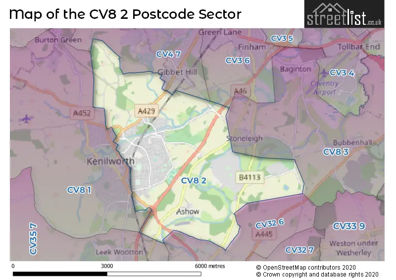
The CV8 2 postcode sector stands on the Warwickshire and West Midlands border.
Did you know? According to the 2021 Census, the CV8 2 postcode sector is home to a bustling 13,235 residents!
Given that each sector allows for 400 unique postcode combinations. Letters C, I, K, M, O and V are not allowed in the last two letters of a postcode. With 298 postcodes already in use, this leaves 102 units available.
The largest settlement in the CV8 2 postal code is KENILWORTH followed by Stoneleigh Park, and Ashow.
The CV8 2 Postcode shares a border with CV8 1 (KENILWORTH, Burton Green, Honiley), CV8 3 (Wolston, Ryton On Dunsmore, Baginton), CV3 6 (COVENTRY), CV4 7 (COVENTRY), CV32 6 (LEAMINGTON SPA, Blackdown, Old Milverton) and CV35 7 (Hatton Park, Hatton, Leek Wootton).
The sector is within the post town of KENILWORTH.
CV8 2 is a postcode sector within the CV8 postcode district which is within the CV Coventry postcode area.
The Royal Mail delivery office for the CV8 2 postal sector is the Kenilworth Delivery Office.
The area of the CV8 2 postcode sector is 8.14 square miles which is 21.08 square kilometres or 5,207.99 square acres.
The CV8 2 postcode sector is crossed by the A46 Major A road.
Waterways within the CV8 2 postcode sector include the River Avon, River Sowe, Finham Brook.

Map of the CV8 2 Postcode Sector
Explore the CV8 2 postcode sector by using our free interactive map.
| C | V | 8 | - | 2 | X | X |
| C | V | 8 | Space | 2 | Letter | Letter |
Official List of Streets
Stareton (1 Streets)
KENILWORTH (197 Streets)
Ashow (1 Streets)
Unofficial Streets or Alternative Spellings
KENILWORTH
FIELDGATE LANE PEARS CLOSECOVENTRY
KENILWORTH ROAD STONELEIGH ROAD 10A STREET 10TH STREET 11TH STREET 1ST STREET 2ND STREET 3RD STREET 4TH STREET 5TH STREET 6TH STREET 7TH STREET 8TH STREET 9TH STREET ALDRIDGE CRESCENT ARBOURFIELDS CLOSE AVENUE A AVENUE B AVENUE C AVENUE D AVENUE E AVENUE F AVENUE G AVENUE H AVENUE J AVENUE K AVENUE L AVENUE M AVENUE N AVENUE P AVENUE Q AVENUE R AVENUE Z BLACKTHORNE ROAD CLEMENTS ROAD DALEBROOK PLACE DENEMOOR COURT GREENWAY BRIDGE GROVE LANE KENILWORTH BYPASS KENILWORTH GREENWAY KENILWORTH GREENWAY SPUR KENILWORTH LODGE MILL BANK MEWS MOUNTBATEN AVENUE PRINCES DRIVE ROCKY LANE RYE MEADOW STARE BRIDGE STARETON LANE STONELEIGH JUNCTION THE CONIFERS THE COURTYARD THICKTHORN ROUNDABOUT WARWICK BY-PASS WYNCOTE CLOSEBlackdown
BERICOTE ROAD KENILWORTH ROAD STONELEIGH ROADLeek Wootton
WARWICK ROADCOVENTRY,
CRYFIELD GRANGE ROADWeather Forecast for CV8 2
Press Button to Show Forecast for Stoneleigh Abbey Grounds
| Time Period | Icon | Description | Temperature | Rain Probability | Wind |
|---|---|---|---|---|---|
| 09:00 to 12:00 | Light rain | 7.0°C (feels like 4.0°C) | 52.00% | ENE 9 mph | |
| 12:00 to 15:00 | Overcast | 8.0°C (feels like 5.0°C) | 18.00% | NE 11 mph | |
| 15:00 to 18:00 | Overcast | 9.0°C (feels like 6.0°C) | 13.00% | NE 11 mph | |
| 18:00 to 21:00 | Overcast | 8.0°C (feels like 5.0°C) | 13.00% | NE 11 mph | |
| 21:00 to 00:00 | Overcast | 7.0°C (feels like 4.0°C) | 12.00% | NE 11 mph |
Press Button to Show Forecast for Stoneleigh Abbey Grounds
| Time Period | Icon | Description | Temperature | Rain Probability | Wind |
|---|---|---|---|---|---|
| 00:00 to 03:00 | Overcast | 6.0°C (feels like 3.0°C) | 21.00% | NNE 11 mph | |
| 03:00 to 06:00 | Light rain | 6.0°C (feels like 2.0°C) | 53.00% | NNE 13 mph | |
| 06:00 to 09:00 | Heavy rain | 6.0°C (feels like 2.0°C) | 80.00% | N 11 mph | |
| 09:00 to 12:00 | Heavy rain | 7.0°C (feels like 4.0°C) | 80.00% | NNW 11 mph | |
| 12:00 to 15:00 | Light rain | 9.0°C (feels like 6.0°C) | 53.00% | NW 9 mph | |
| 15:00 to 18:00 | Overcast | 10.0°C (feels like 8.0°C) | 17.00% | WNW 9 mph | |
| 18:00 to 21:00 | Partly cloudy (day) | 10.0°C (feels like 8.0°C) | 7.00% | WSW 7 mph | |
| 21:00 to 00:00 | Clear night | 7.0°C (feels like 5.0°C) | 2.00% | SW 7 mph |
Press Button to Show Forecast for Stoneleigh Abbey Grounds
| Time Period | Icon | Description | Temperature | Rain Probability | Wind |
|---|---|---|---|---|---|
| 00:00 to 03:00 | Clear night | 6.0°C (feels like 4.0°C) | 1.00% | SW 7 mph | |
| 03:00 to 06:00 | Clear night | 4.0°C (feels like 2.0°C) | 1.00% | SSW 7 mph | |
| 06:00 to 09:00 | Sunny day | 6.0°C (feels like 3.0°C) | 1.00% | S 7 mph | |
| 09:00 to 12:00 | Sunny day | 11.0°C (feels like 8.0°C) | 1.00% | S 11 mph | |
| 12:00 to 15:00 | Cloudy | 13.0°C (feels like 11.0°C) | 8.00% | S 13 mph | |
| 15:00 to 18:00 | Cloudy | 14.0°C (feels like 11.0°C) | 6.00% | S 13 mph | |
| 18:00 to 21:00 | Sunny day | 13.0°C (feels like 11.0°C) | 3.00% | S 11 mph | |
| 21:00 to 00:00 | Clear night | 9.0°C (feels like 7.0°C) | 3.00% | SSE 9 mph |
Press Button to Show Forecast for Stoneleigh Abbey Grounds
| Time Period | Icon | Description | Temperature | Rain Probability | Wind |
|---|---|---|---|---|---|
| 00:00 to 03:00 | Clear night | 8.0°C (feels like 6.0°C) | 3.00% | SE 9 mph | |
| 03:00 to 06:00 | Clear night | 7.0°C (feels like 5.0°C) | 2.00% | SE 9 mph | |
| 06:00 to 09:00 | Sunny day | 8.0°C (feels like 6.0°C) | 4.00% | ESE 9 mph | |
| 09:00 to 12:00 | Sunny day | 13.0°C (feels like 11.0°C) | 5.00% | SE 11 mph | |
| 12:00 to 15:00 | Partly cloudy (day) | 15.0°C (feels like 13.0°C) | 9.00% | SE 13 mph | |
| 15:00 to 18:00 | Partly cloudy (day) | 16.0°C (feels like 14.0°C) | 8.00% | SE 11 mph | |
| 18:00 to 21:00 | Cloudy | 15.0°C (feels like 13.0°C) | 9.00% | ESE 9 mph | |
| 21:00 to 00:00 | Partly cloudy (night) | 12.0°C (feels like 10.0°C) | 6.00% | ESE 7 mph |
Schools and Places of Education Within the CV8 2 Postcode Sector
Kenilworth School and Sixth Form
Academy converter
Glasshouse Lane, Kenilworth, , CV8 2AL
Head: Mr Darren Nicholas
Ofsted Rating: Outstanding
Inspection: 2023-11-08 (171 days ago)
Website: Visit Kenilworth School and Sixth Form Website
Phone: 01926859421
Number of Pupils: 1834
Park Hill Junior School
Community school
Parkfield Drive, Kenilworth, Warwickshire, CV8 2JJ
Head: Mrs Liz Bradbury
Ofsted Rating: Good
Inspection: 2022-03-11 (778 days ago)
Website: Visit Park Hill Junior School Website
Phone: 01926855974
Number of Pupils: 260
St Nicholas CofE Primary School
Voluntary controlled school
Priory Road, Kenilworth, Warwickshire, CV8 2PE
Head: Mrs Sarah Rayson
Ofsted Rating: Good
Inspection: 2019-01-22 (1922 days ago)
Website: Visit St Nicholas CofE Primary School Website
Phone: 01926853257
Number of Pupils: 420
Thorns Community Infant School
Community school
Blackthorn Road, Kenilworth, Warwickshire, CV8 2DS
Head: Mrs Elizabeth Bradbury
Ofsted Rating: Good
Inspection: 2022-03-02 (787 days ago)
Website: Visit Thorns Community Infant School Website
Phone: 01926853875
Number of Pupils: 152
House Prices in the CV8 2 Postcode Sector
| Type of Property | 2018 Average | 2018 Sales | 2017 Average | 2017 Sales | 2016 Average | 2016 Sales | 2015 Average | 2015 Sales |
|---|---|---|---|---|---|---|---|---|
| Detached | £612,378 | 83 | £535,555 | 75 | £492,410 | 72 | £467,356 | 79 |
| Semi-Detached | £326,292 | 77 | £347,132 | 79 | £324,507 | 63 | £288,344 | 79 |
| Terraced | £284,981 | 57 | £262,905 | 53 | £253,750 | 57 | £235,427 | 55 |
| Flats | £156,016 | 27 | £168,670 | 20 | £153,823 | 33 | £144,929 | 39 |
Important Postcodes CV8 2 in the Postcode Sector
CV8 2DA is the postcode for MAIN BUILDING (LOWER SCHOOL), Warwickshire County Council, Kenilworth School, Leyes Lane, Kenilworth School and Sixth Form (Upper School), Leyes Lane, Kenilworth School and Sixth Form (Lower School), Leyes Lane, SPORTS HALL (LOWER SCHOOL), Warwickshire County Council, Kenilworth School, Leyes Lane, ADMIN/LRC BLOCK, Warwickshire County Council, Kenilworth School, Leyes Lane, MAIN BUILDING UPPER SCHOOL, Warwickshire County Council, Kenilworth School, Leyes Lane, Kenilworth School and Sixth Form (Sports Hall), Leyes Lane, and Warwickshire County Council, Kenilworth School, Leyes Lane
CV8 2DS is the postcode for MAIN BUILDING, Warwickshire County Council, Thorns County First School, Blackthorn Road, and MAIN BUILDING, Thorns Community Infant School, Blackthorn Road
CV8 2JJ is the postcode for MAIN BUILDING, Park Hill Junior School, Parkfield Drive
CV8 2JY is the postcode for Warwickshire County Council, St. Augustines RC Combined School, Hollis Lane, and ST AUGUSTINES CATHOLIC PRIMARY SCHOOL, HOLLIS LANE, KENILWORTH
CV8 2PE is the postcode for The Blundells, and MAIN BUILDING, St Nicholas C of E Primary School, The Blundells
| The CV8 2 Sector is within these Local Authorities |
|
|---|---|
| The CV8 2 Sector is within these Counties |
|
| The CV8 2 Sector is within these Water Company Areas |
|