The DA4 0 postcode sector is within the county of Kent.
Did you know? According to the 2021 Census, the DA4 0 postcode sector is home to a bustling 3,222 residents!
Given that each sector allows for 400 unique postcode combinations. Letters C, I, K, M, O and V are not allowed in the last two letters of a postcode. With 105 postcodes already in use, this leaves 295 units available.
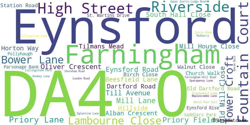
The largest settlements in the DA4 0 postal code are EYNSFORD and Farningham.
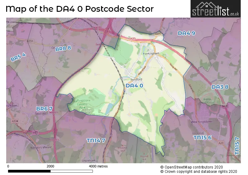
The DA4 0 Postcode shares a border with TN15 6 (West Kingsdown, KEMSING, Knatts Valley), BR6 7 (ORPINGTON , DOWNE , FARNBOROUGH ), DA3 8 (New Ash Green, Hartley, Fawkham), DA4 9 (South Darenth, Sutton At Hone, Horton Kirby), TN14 7 (HALSTEAD, Knockholt, SHOREHAM) and BR8 8 (SWANLEY , CROCKENHILL ).
The sector is within the post town of DARTFORD.
DA4 0 is a postcode sector within the DA4 postcode district which is within the DA Dartford postcode area.
The Royal Mail delivery office for the DA4 0 postal sector is the Dartford Delivery Office.
The area of the DA4 0 postcode sector is 8.06 square miles which is 20.88 square kilometres or 5,158.89 square acres.
The DA4 0 postcode sector is crossed by the M25 motorway.
The DA4 0 postcode sector is crossed by the M20 motorway.
Waterways within the DA4 0 postcode sector include the Darent.

Map of the DA4 0 Postcode Sector
Explore the DA4 0 postcode sector by using our free interactive map.
| D | A | 4 | - | 0 | X | X |
| D | A | 4 | Space | 0 | Letter | Letter |
Official List of Streets
Farningham (21 Streets)
Eynsford (25 Streets)
Unofficial Streets or Alternative Spellings
Knatts Valley
KNATTS VALLEY ROADWest Kingsdown
BOTSOM LANEFarningham
CALFSTOCK LANE EDWARDS COURT FARNINGHAM HIGH STREET GIBSONS PLACE KNIGHTS FIELD MAIN ROAD MAIN ROAD GORSE HILL POLLYHOUGH RABLUS PLACE SD196 SD198 TOLLGATE YARD WOODLAND WALKHorton Kirby
EGLANTINE LANEORPINGTON
PARKGATE ROADSWANLEY
BUTTON STREETWeather Forecast for DA4 0
Press Button to Show Forecast for Brands Hatch
| Time Period | Icon | Description | Temperature | Rain Probability | Wind |
|---|---|---|---|---|---|
| 06:00 to 09:00 | Cloudy | 4.0°C (feels like 1.0°C) | 6.00% | NE 7 mph | |
| 09:00 to 12:00 | Cloudy | 6.0°C (feels like 4.0°C) | 6.00% | ENE 9 mph | |
| 12:00 to 15:00 | Cloudy | 9.0°C (feels like 7.0°C) | 15.00% | ENE 7 mph | |
| 15:00 to 18:00 | Overcast | 9.0°C (feels like 8.0°C) | 15.00% | ENE 7 mph | |
| 18:00 to 21:00 | Cloudy | 8.0°C (feels like 7.0°C) | 12.00% | E 7 mph | |
| 21:00 to 00:00 | Cloudy | 5.0°C (feels like 3.0°C) | 13.00% | E 7 mph |
Press Button to Show Forecast for Brands Hatch
| Time Period | Icon | Description | Temperature | Rain Probability | Wind |
|---|---|---|---|---|---|
| 00:00 to 03:00 | Cloudy | 4.0°C (feels like 2.0°C) | 16.00% | ENE 7 mph | |
| 03:00 to 06:00 | Overcast | 4.0°C (feels like 2.0°C) | 20.00% | NE 7 mph | |
| 06:00 to 09:00 | Cloudy | 5.0°C (feels like 3.0°C) | 18.00% | NE 9 mph | |
| 09:00 to 12:00 | Overcast | 9.0°C (feels like 7.0°C) | 19.00% | E 9 mph | |
| 12:00 to 15:00 | Cloudy | 11.0°C (feels like 9.0°C) | 18.00% | E 11 mph | |
| 15:00 to 18:00 | Light rain | 11.0°C (feels like 8.0°C) | 49.00% | E 11 mph | |
| 18:00 to 21:00 | Light rain | 9.0°C (feels like 7.0°C) | 55.00% | ENE 11 mph | |
| 21:00 to 00:00 | Light rain | 9.0°C (feels like 6.0°C) | 51.00% | ENE 11 mph |
Press Button to Show Forecast for Brands Hatch
| Time Period | Icon | Description | Temperature | Rain Probability | Wind |
|---|---|---|---|---|---|
| 00:00 to 03:00 | Heavy rain | 9.0°C (feels like 6.0°C) | 77.00% | ENE 9 mph | |
| 03:00 to 06:00 | Light rain | 9.0°C (feels like 6.0°C) | 50.00% | SE 11 mph | |
| 06:00 to 09:00 | Light rain | 9.0°C (feels like 6.0°C) | 50.00% | SSE 11 mph | |
| 09:00 to 12:00 | Light rain shower (day) | 10.0°C (feels like 7.0°C) | 42.00% | SSE 13 mph | |
| 12:00 to 15:00 | Heavy rain shower (day) | 12.0°C (feels like 9.0°C) | 61.00% | SSW 13 mph | |
| 15:00 to 18:00 | Light rain shower (day) | 13.0°C (feels like 10.0°C) | 40.00% | SW 13 mph | |
| 18:00 to 21:00 | Light rain shower (day) | 11.0°C (feels like 9.0°C) | 35.00% | WSW 11 mph | |
| 21:00 to 00:00 | Cloudy | 9.0°C (feels like 6.0°C) | 8.00% | SW 9 mph |
Schools and Places of Education Within the DA4 0 Postcode Sector
The Anthony Roper Primary School
Foundation school
High Street, Dartford, Kent, DA4 0AA
Head: Mr Adam Nicholls
Ofsted Rating: Good
Inspection: 2019-06-27 (1765 days ago)
Website: Visit The Anthony Roper Primary School Website
Phone: 01322863680
Number of Pupils: 307
House Prices in the DA4 0 Postcode Sector
| Type of Property | 2018 Average | 2018 Sales | 2017 Average | 2017 Sales | 2016 Average | 2016 Sales | 2015 Average | 2015 Sales |
|---|---|---|---|---|---|---|---|---|
| Detached | £705,882 | 17 | £687,250 | 14 | £592,455 | 11 | £581,333 | 23 |
| Semi-Detached | £476,352 | 14 | £426,778 | 9 | £376,812 | 14 | £489,750 | 6 |
| Terraced | £349,852 | 12 | £394,012 | 13 | £360,356 | 17 | £380,354 | 24 |
| Flats | £158,125 | 4 | £196,583 | 6 | £180,745 | 10 | £349,643 | 14 |
Important Postcodes DA4 0 in the Postcode Sector
DA4 0AA is the postcode for THE ANTHONY ROPER PRIMARY SCHOOL, HIGH STREET, EYNSFORD, Anthony Roper Cp School, High Street, and The Anthony Roper Primary School, High Street
DA4 0JF is the postcode for Lullingstone Park Visitor Centre, Kingfisher Bridge, Castle Road
| The DA4 0 Sector is within these Local Authorities |
|
|---|---|
| The DA4 0 Sector is within these Counties |
|
| The DA4 0 Sector is within these Water Company Areas |
|
Tourist Attractions within the DA4 0 Postcode Area
We found 2 visitor attractions within the DA4 postcode area
| Lullingstone Castle & Lullingstone World Garden |
|---|
| Gardens |
| Garden |
| View Lullingstone Castle & Lullingstone World Garden on Google Maps |
| Lullingstone Roman Villa |
| Historic Properties |
| Historic Monument / Archaeological Site |
| View Lullingstone Roman Villa on Google Maps |