The DE4 3 postcode sector is within the county of Derbyshire.
Did you know? According to the 2021 Census, the DE4 3 postcode sector is home to a bustling 11,996 residents!
Given that each sector allows for 400 unique postcode combinations. Letters C, I, K, M, O and V are not allowed in the last two letters of a postcode. With 290 postcodes already in use, this leaves 110 units available.
The largest settlement in the DE4 3 postal code is MATLOCK followed by Cromford, and Matlock Bath.
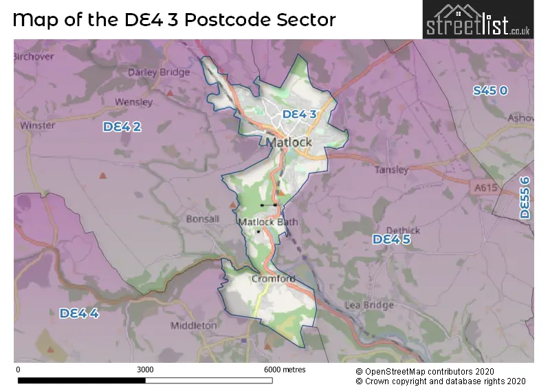
The DE4 3 Postcode shares a border with DE4 2 (Darley Dale, Winster, Bonsall), DE4 4 (Wirksworth, Brassington, Middleton) and DE4 5 (Crich, Tansley, Whatstandwell).
The sector is within the post town of MATLOCK.
DE4 3 is a postcode sector within the DE4 postcode district which is within the DE Derby postcode area.
The Royal Mail delivery office for the DE4 3 postal sector is the Matlock Delivery Office.
The area of the DE4 3 postcode sector is 3.96 square miles which is 10.25 square kilometres or 2,532.54 square acres.
Waterways within the DE4 3 postcode sector include the Derwent, River Derwent, Cromford Canal.

Map of the DE4 3 Postcode Sector
Explore the DE4 3 postcode sector by using our free interactive map.
| D | E | 4 | - | 3 | X | X |
| D | E | 4 | Space | 3 | Letter | Letter |
Official List of Streets
MATLOCK (157 Streets)
Cromford (24 Streets)
Matlock Bath (15 Streets)
Unofficial Streets or Alternative Spellings
Matlock Moor
CHESTERFIELD ROADMATLOCK
LUMSDALE ROAD SALTERS LANE SMUSE LANEHackney
BURNETT LANE HACKNEY ROAD OLD HACKNEY LANEStarkholmes
STARKHOLMES ROADFarley
FARLEY HILLDarley Dale
DALE ROAD SOUTHWeather Forecast for DE4 3
Press Button to Show Forecast for Matlock Youth Hostel
| Time Period | Icon | Description | Temperature | Rain Probability | Wind |
|---|---|---|---|---|---|
| 21:00 to 00:00 | Cloudy | 4.0°C (feels like 2.0°C) | 5.00% | ENE 7 mph |
Press Button to Show Forecast for Matlock Youth Hostel
| Time Period | Icon | Description | Temperature | Rain Probability | Wind |
|---|---|---|---|---|---|
| 00:00 to 03:00 | Cloudy | 3.0°C (feels like 1.0°C) | 6.00% | NE 7 mph | |
| 03:00 to 06:00 | Partly cloudy (night) | 3.0°C (feels like 0.0°C) | 4.00% | NE 7 mph | |
| 06:00 to 09:00 | Cloudy | 3.0°C (feels like 1.0°C) | 7.00% | NNE 7 mph | |
| 09:00 to 12:00 | Cloudy | 6.0°C (feels like 3.0°C) | 23.00% | NE 9 mph | |
| 12:00 to 15:00 | Light rain | 7.0°C (feels like 4.0°C) | 55.00% | ENE 11 mph | |
| 15:00 to 18:00 | Overcast | 7.0°C (feels like 4.0°C) | 16.00% | ENE 9 mph | |
| 18:00 to 21:00 | Overcast | 6.0°C (feels like 4.0°C) | 12.00% | NE 9 mph | |
| 21:00 to 00:00 | Overcast | 5.0°C (feels like 2.0°C) | 12.00% | NE 9 mph |
Press Button to Show Forecast for Matlock Youth Hostel
| Time Period | Icon | Description | Temperature | Rain Probability | Wind |
|---|---|---|---|---|---|
| 00:00 to 03:00 | Cloudy | 5.0°C (feels like 1.0°C) | 13.00% | NNE 9 mph | |
| 03:00 to 06:00 | Overcast | 4.0°C (feels like 1.0°C) | 19.00% | N 11 mph | |
| 06:00 to 09:00 | Light rain | 5.0°C (feels like 1.0°C) | 52.00% | NNW 11 mph | |
| 09:00 to 12:00 | Light rain | 6.0°C (feels like 2.0°C) | 53.00% | NNW 11 mph | |
| 12:00 to 15:00 | Light rain | 8.0°C (feels like 5.0°C) | 50.00% | NW 11 mph | |
| 15:00 to 18:00 | Cloudy | 9.0°C (feels like 7.0°C) | 15.00% | WNW 11 mph | |
| 18:00 to 21:00 | Sunny day | 8.0°C (feels like 6.0°C) | 6.00% | W 9 mph | |
| 21:00 to 00:00 | Clear night | 5.0°C (feels like 3.0°C) | 3.00% | WSW 7 mph |
Press Button to Show Forecast for Matlock Youth Hostel
| Time Period | Icon | Description | Temperature | Rain Probability | Wind |
|---|---|---|---|---|---|
| 00:00 to 03:00 | Clear night | 3.0°C (feels like 1.0°C) | 1.00% | SW 7 mph | |
| 03:00 to 06:00 | Clear night | 2.0°C (feels like -1.0°C) | 1.00% | SSW 7 mph | |
| 06:00 to 09:00 | Sunny day | 4.0°C (feels like 1.0°C) | 2.00% | SSW 7 mph | |
| 09:00 to 12:00 | Partly cloudy (day) | 9.0°C (feels like 6.0°C) | 2.00% | S 11 mph | |
| 12:00 to 15:00 | Cloudy | 12.0°C (feels like 9.0°C) | 6.00% | S 13 mph | |
| 15:00 to 18:00 | Cloudy | 12.0°C (feels like 10.0°C) | 7.00% | S 13 mph | |
| 18:00 to 21:00 | Partly cloudy (day) | 11.0°C (feels like 9.0°C) | 4.00% | S 11 mph | |
| 21:00 to 00:00 | Clear night | 8.0°C (feels like 6.0°C) | 3.00% | SSE 9 mph |
Press Button to Show Forecast for Matlock Youth Hostel
| Time Period | Icon | Description | Temperature | Rain Probability | Wind |
|---|---|---|---|---|---|
| 00:00 to 03:00 | Clear night | 7.0°C (feels like 4.0°C) | 2.00% | SSE 9 mph | |
| 03:00 to 06:00 | Clear night | 5.0°C (feels like 2.0°C) | 4.00% | SE 7 mph | |
| 06:00 to 09:00 | Sunny day | 7.0°C (feels like 4.0°C) | 4.00% | ESE 7 mph | |
| 09:00 to 12:00 | Partly cloudy (day) | 11.0°C (feels like 9.0°C) | 5.00% | ESE 9 mph | |
| 12:00 to 15:00 | Partly cloudy (day) | 14.0°C (feels like 11.0°C) | 7.00% | SE 11 mph | |
| 15:00 to 18:00 | Partly cloudy (day) | 15.0°C (feels like 12.0°C) | 10.00% | ESE 11 mph | |
| 18:00 to 21:00 | Cloudy | 13.0°C (feels like 11.0°C) | 8.00% | ESE 9 mph | |
| 21:00 to 00:00 | Cloudy | 10.0°C (feels like 9.0°C) | 9.00% | E 7 mph |
Schools and Places of Education Within the DE4 3 Postcode Sector
All Saints CofE Infant School
Academy converter
Dimple Road, Matlock, Derbyshire, DE4 3HX
Head: Mr Ben O'Connell
Ofsted Rating: Good
Inspection: 2019-12-04 (1605 days ago)
Website: Visit All Saints CofE Infant School Website
Phone: 01629582913
Number of Pupils: 162
All Saints CofE Junior School
Academy converter
Hurds Hollow, Matlock, Derbyshire, DE4 3LA
Head: Mr Ben O'Connell
Ofsted Rating: Good
Inspection: 2021-09-16 (953 days ago)
Website: Visit All Saints CofE Junior School Website
Phone: 01629582913
Number of Pupils: 233
Castle View Primary School
Academy converter
School Road, Matlock, Derbyshire, DE4 3DS
Head: Miss Amie Wilton
Ofsted Rating: Requires improvement
Inspection: 2022-06-29 (667 days ago)
Website: Visit Castle View Primary School Website
Phone: 01629582699
Number of Pupils: 158
Cromford Church of England Primary School
Voluntary controlled school
North Street, Matlock, Derbyshire, DE4 3RG
Head: Mrs Elizabeth Foster
Ofsted Rating: Good
Inspection: 2022-11-03 (540 days ago)
Website: Visit Cromford Church of England Primary School Website
Phone: 01629822248
Number of Pupils: 68
Matlock Bath Holy Trinity CofE Controlled Primary School
Voluntary controlled school
14 Clifton Road, Matlock, Derbyshire, DE4 3PW
Head: Mr Chris Layhe-Humphreys
Ofsted Rating: Good
Inspection: 2023-03-02 (421 days ago)
Website: Visit Matlock Bath Holy Trinity CofE Controlled Primary School Website
Phone: 01629582862
Number of Pupils: 45
St Giles Church of England Primary School
Academy sponsor led
Starkholmes Road, Matlock, Derbyshire, DE4 3DD
Head: Mr Ben O'Connell
Ofsted Rating: Good
Inspection: 2018-06-13 (2144 days ago)
Website: Visit St Giles Church of England Primary School Website
Phone: 0162956813
Number of Pupils: 92
St Joseph's Catholic Voluntary Academy
Academy sponsor led
Chesterfield Road, Matlock, Derbyshire, DE4 3FT
Head: Mrs Stacey Carr
Ofsted Rating: Good
Inspection: 2019-09-18 (1682 days ago)
Website: Visit St Joseph's Catholic Voluntary Academy Website
Phone: 01629583616
Number of Pupils: 126
House Prices in the DE4 3 Postcode Sector
| Type of Property | 2018 Average | 2018 Sales | 2017 Average | 2017 Sales | 2016 Average | 2016 Sales | 2015 Average | 2015 Sales |
|---|---|---|---|---|---|---|---|---|
| Detached | £347,649 | 67 | £291,401 | 49 | £299,780 | 49 | £316,428 | 55 |
| Semi-Detached | £218,138 | 80 | £194,482 | 76 | £174,466 | 75 | £175,044 | 71 |
| Terraced | £165,484 | 65 | £180,815 | 55 | £169,454 | 70 | £170,273 | 68 |
| Flats | £193,039 | 18 | £137,850 | 24 | £123,037 | 28 | £129,271 | 29 |
Important Postcodes DE4 3 in the Postcode Sector
DE4 3AA is the postcode for Royal Mail, Matlock Delivery Office, 14 Bank Road
DE4 3AG is the postcode for NORTH BLOCK, Derbyshire County Council, County Offices,, SOUTH BLOCK - 01, Derbyshire County Council, County Offices,, South Block - 01, Derbyshire County Council, County Offices, SOUTH BLOCK - 01, Derbyshire County Council, County Office, North Block, Derbyshire County Council, County Offices, and BLOCK 4, Derbyshire County Council, County Offices,
DE4 3AR is the postcode for Patience, Ritz Building, Causeway Lane
DE4 3AZ is the postcode for Arc Leisure Matlock, Bakewell Road
DE4 3DD is the postcode for BLOCK 1, Highfields Lower School, Starkholmes Road, Highfields Lower School, Starkholmes Road, and HIGHFIELDS LOWER SCHOOL, STARKHOLMES ROAD, MATLOCK
DE4 3DP is the postcode for Derbyshire County Council, Matlock Library, Steep Turnpike, and Adult Community Education Centre, The Ritz, Steep Turnpike
DE4 3DQ is the postcode for Derbyshire Fire & Rescue Service, Fire Station, Chesterfield Road
DE4 3DS is the postcode for OFFICE BLOCK, Castle View Primary School, School Road, and MAIN BUILDING, Castle View Primary School, School Road
DE4 3EJ is the postcode for Ambulance Station, Lime Tree Road
DE4 3FD is the postcode for Jobcentre Plus, The Phoenix Centre, 2 Lime Grove Walk, and Lime Grove Medical Centre, Lime Grove Walk
DE4 3FE is the postcode for Derbyshire Record Office, New Street, and Main Building, Derbyshire Record Office, New Street
DE4 3FT is the postcode for St. Joseph Catholic Primary School, Chesterfield Road
DE4 3FW is the postcode for D BLOCK/TRADING STANDARDS, Chatsworth Hall, Chesterfield Road, B BLOCK, Chatsworth Hall, Chesterfield Road, and A BLOCK, Chatsworth Hall, Chesterfield Road
DE4 3HX is the postcode for BLOCK A, Matlock All Saints C of E Infant School, Dimple Road, and BLOCK B, Matlock All Saints C of E Infant School, Dimple Road
DE4 3LA is the postcode for ALL SAINTS CHURCH OF ENGLAND VOLUNTARY CONTROLLED JUNIOR SCHOOL, HURDS HOLLOW, MATLOCK, and All Saints C of E Voluntary Controlled Junior School, Hurds Hollow
DE4 3NF is the postcode for Matlock Police Office, Bank Road
DE4 3NL is the postcode for The Surgery, 8 Imperial Road, Matlock Lido, 1 Imperial Road, and Imperial Rooms, Imperial Road
DE4 3NN is the postcode for Town Hall, Bank Road, and Derbyshire Dales District Council, Town Hall, Bank Road
DE4 3PW is the postcode for The Maiin Building, Matlock Bath Holy Trinity CofE (VC) Primary School, Clifton Road
DE4 3RD is the postcode for John Hadfield House, Dale Road, and Main Building, John Hadfield House, Dale Road
DE4 3RY is the postcode for Shand House, Dale Road South, Whole Building, Shand House, Dale Road South, and D C C Environmental Services, Shand House, Dale Road South
| The DE4 3 Sector is within these Local Authorities |
|
|---|---|
| The DE4 3 Sector is within these Counties |
|
| The DE4 3 Sector is within these Water Company Areas |
|