DG11 2QG is a postal code used within the United Kingdom for delivering mail.
Postcodes are made up of two parts. The part before the space (DG11) is called the outward code. The part after the space (2QG) is called the inward code. The letters C, I, K, M, O and V are not allowed in the inward code. In addition to the inward and outward code, the postcode can be broken up into four parts:
- Postal Area. In our case DG which means Dumfries and Galloway.
- Postal District. In our case DG11.
- Postal Sector. In our case DG11 2.
- Postcode Unit. The last two letters. In our case QG.
The regional mail center for the post area DG is the North West Distribution Centre, which is located at Mill Lane, Winwick Quay, WARRINGTON, WA2 8RJ.
The final port of call for any post addressed to the DG11 2QG postcode is the local delivery office (DO) which is LOCKERBIE DO. Here the post will be sorted ready for delivery.
It is situated within the post town of LOCKERBIE within the old postal county of Dumfriesshire.
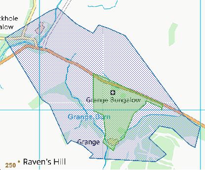
DG11 2QG is within Corrie Common.
Interactive Mapping Showing UPRNs within the DG11 2QG Postcode Boundaries
Use the search box to search for other postcodes or places.
Map Coordinates for DG11 2QG
| Latitude | 55.1364204856 |
|---|---|
| Longitude | -3.20219934999 |
Ordnance Survey Maps for DG11 2QG
| Map Series | Amazon | Ordnance Survey |
| Explorer 1:25,000 323 Eskdale and Castle O'er Forest | Check Price on Amazon | Buy Direct from the Ordnance Survey |
| Landranger 1:50,000 79 Hawick & Eskdale | Check Price on Amazon | Buy Direct from the Ordnance Survey |
Weather Forecast for DG11 2QG
Mon 29th Apr
Press Button to Show Forecast for Lockerbie
| Time Period | Icon | Description | Temperature | Rain Probability | Wind |
|---|---|---|---|---|---|
| 15:00 to 18:00 | Heavy rain | 10.0°C (feels like 6.0°C) | 93.00% | S 18 mph | |
| 18:00 to 21:00 | Overcast | 10.0°C (feels like 7.0°C) | 55.00% | S 18 mph | |
| 21:00 to 00:00 | Cloudy | 9.0°C (feels like 7.0°C) | 51.00% | S 13 mph |
Tue 30th Apr
Press Button to Show Forecast for Lockerbie
| Time Period | Icon | Description | Temperature | Rain Probability | Wind |
|---|---|---|---|---|---|
| 00:00 to 03:00 | Cloudy | 9.0°C (feels like 7.0°C) | 11.00% | S 11 mph | |
| 03:00 to 06:00 | Cloudy | 9.0°C (feels like 6.0°C) | 15.00% | SE 9 mph | |
| 06:00 to 09:00 | Light rain | 9.0°C (feels like 6.0°C) | 59.00% | SE 11 mph | |
| 09:00 to 12:00 | Cloudy | 11.0°C (feels like 9.0°C) | 15.00% | SE 11 mph | |
| 12:00 to 15:00 | Partly cloudy (day) | 14.0°C (feels like 11.0°C) | 3.00% | SSE 13 mph | |
| 15:00 to 18:00 | Cloudy | 15.0°C (feels like 12.0°C) | 8.00% | SSE 11 mph | |
| 18:00 to 21:00 | Cloudy | 13.0°C (feels like 12.0°C) | 7.00% | SSE 9 mph | |
| 21:00 to 00:00 | Cloudy | 10.0°C (feels like 9.0°C) | 7.00% | SE 4 mph |
Wed 1st May
Press Button to Show Forecast for Lockerbie
| Time Period | Icon | Description | Temperature | Rain Probability | Wind |
|---|---|---|---|---|---|
| 00:00 to 03:00 | Cloudy | 9.0°C (feels like 8.0°C) | 9.00% | NNE 4 mph | |
| 03:00 to 06:00 | Light rain | 8.0°C (feels like 7.0°C) | 41.00% | ENE 4 mph | |
| 06:00 to 09:00 | Cloudy | 9.0°C (feels like 8.0°C) | 9.00% | E 4 mph | |
| 09:00 to 12:00 | Partly cloudy (day) | 12.0°C (feels like 11.0°C) | 4.00% | ESE 7 mph | |
| 12:00 to 15:00 | Partly cloudy (day) | 15.0°C (feels like 14.0°C) | 6.00% | SE 7 mph | |
| 15:00 to 18:00 | Partly cloudy (day) | 15.0°C (feels like 14.0°C) | 6.00% | SSE 7 mph | |
| 18:00 to 21:00 | Cloudy | 14.0°C (feels like 13.0°C) | 8.00% | SSE 7 mph | |
| 21:00 to 00:00 | Cloudy | 11.0°C (feels like 10.0°C) | 5.00% | N 7 mph |
Thu 2nd May
Press Button to Show Forecast for Lockerbie
| Time Period | Icon | Description | Temperature | Rain Probability | Wind |
|---|---|---|---|---|---|
| 00:00 to 03:00 | Cloudy | 10.0°C (feels like 8.0°C) | 7.00% | N 7 mph | |
| 03:00 to 06:00 | Cloudy | 9.0°C (feels like 7.0°C) | 6.00% | N 7 mph | |
| 06:00 to 09:00 | Cloudy | 10.0°C (feels like 8.0°C) | 6.00% | N 9 mph | |
| 09:00 to 12:00 | Partly cloudy (day) | 13.0°C (feels like 11.0°C) | 2.00% | NE 11 mph | |
| 12:00 to 15:00 | Partly cloudy (day) | 16.0°C (feels like 13.0°C) | 1.00% | N 11 mph | |
| 15:00 to 18:00 | Sunny day | 16.0°C (feels like 14.0°C) | 2.00% | NNE 13 mph | |
| 18:00 to 21:00 | Sunny day | 14.0°C (feels like 12.0°C) | 1.00% | N 11 mph | |
| 21:00 to 00:00 | Partly cloudy (night) | 10.0°C (feels like 8.0°C) | 1.00% | N 9 mph |
Schools within a five minute drive of DG11 2QG Postcode
Scotland Primary Schools
Hottsbridge School
Address: Hottsbridge School, Waterbeck, Lockerbie, DG11 3HA
Distance: 3.30 miles
Contact: 01461 600243
Nearest Opticians
Opticians near DG11 2QG
ERIC HAGAN OPTICIANS LTD (CARLISLE)
Address: 18 HIGH STREET, LONGTOWN, CARLISLE, CUMBRIA, CA6 5UE
Distance: 12.65 miles
Contact: :
BOOTS OPTICIANS (DUMFRIES - QUEENSBERRY SQUARE)
Address: 22 QUEENSBERRY STREET, DUMFRIES, DUMFRIESSHIRE, DG1 1HR
Distance: 16.78 miles
Contact: :
4640 CARLISLE
Address: ASDA STORES LTD, CHANDLER WAY, PARKHOUSE, CARLISLE, CUMBRIA, CA3 0JQ
Distance: 17.42 miles
Contact: :
C LEE OPTICIANS (THE BIRCHES)
Address: THE BIRCHES, MOORHOUSE, CARLISLE, CUMBRIA, CA5 6EY
Distance: 17.48 miles
Contact: :
C LEE DOMICILILARY EYECARE (CARLISLE)
Address: THE BIRCHES, MOORHOUSE, CARLISLE, CUMBRIA, CA5 6EY
Distance: 17.48 miles
Contact: :
OSPREY OPTICIANS LTD
Address: 22 PUNTON ROAD, CARLISLE, CA3 9BB
Distance: 19.11 miles
Contact: :
Nearest GP Surgeries
Doctors near DG11 2QG
ECCLEFECHAN SURGERY
Address: MAIN ROAD, ECCLEFECHAN, LOCKERBIE, DG11 3BT
Distance: 5.90 miles
Contact: tel: 01576 300208
LOCKERBIE MEDICAL PRACTICE
Address: VICTORIA GARDENS, LOCKERBIE, DG11 2BJ
Distance: 6.23 miles
Contact: :
LANGHOLM MEDICAL PARTNERSHIP
Address: HEALTH CENTRE, LANGHOLM, DUMFRIESSHIRE, DG13 0JY
Distance: 8.04 miles
Contact: tel: 01387 383100
LOCHMABEN MEDICAL GROUP
Address: 42-44 HIGH STREET, LOCHMABEN, LOCKERBIE, DG11 1NH
Distance: 9.42 miles
Contact: tel: 01387 810215
GREENCROFT SOUTH MEDICAL GROUP
Address: GREENCROFT MEDICAL CENTRE (SOUTH), GREENCROFT WYND, ANNAN, DUMFRIESSHIRE, DG12 6GS
Distance: 10.64 miles
Contact: tel: 01461 202244
DR N G KELLY & PARTNERS
Address: GREENCROFT MEDICAL CENTRE (NORTH), GREENCROFT WYND, ANNAN, DUMFRIESSHIRE, DG12 6GN
Distance: 10.64 miles
Contact: tel: 01461 202745
Transport Links near DG11 2QG
Train Stations
Nearest stations for postcode: DG11 2QG
- Lockerbie
Lockerbie station, Station Road, Lockerbie, Dumfries & Galloway, DG11 2HADistance: 7.30 milesDriving Time: 9.07 minutes - Gretna Green
Gretna Green station, Station Road, off Glasgow Road, Gretna Green, DG16 5HFDistance: 12.79 milesDriving Time: 15.29 minutes - Annan
Annan station, Station Road, Annan, Dumfries & Galloway, DG12 6ASDistance: 14.06 milesDriving Time: 17.95 minutes - Dumfries
Dumfries station, Lovers Walk, Dumfries, Dumfries & Galloway, DG1 1NFDistance: 19.53 milesDriving Time: 26.37 minutes - Carlisle
Carlisle station, Court Square, Carlisle, Cumbria, CA1 1QZDistance: 23.91 milesDriving Time: 30.36 minutes
Distances represent the quickest route by car.
Motorway Junctions near DG11 2QG
Train Stations
Motorway Junctions near DG11 2QG
Distances represent the quickest route by car.
Who are my Elected Representatives in the DG11 2QG Postcode?
| Westminster Constituency | Dumfriesshire, Clydesdale and Tweeddale Co Const |
|---|---|
| Member or Parliament |  |
| Contact Details | Contact David Mundell |
| Political Party | Conservative |
What Council is the DG11 2QG Postcode in?
The Council for this Postcode is Dumfries and Galloway Council, who are a Unitary authority. This means that they are responsible for providing education, libraries and maintaining highways as well as normal council duties such as council tax, rubbish collection, housing, environmental health and planning.
You can visit the website for Dumfries and Galloway at the following link Dumfries and Galloway.How much is the Council Tax?
Dumfries and Galloway Council is responsible for collecting council tax. This will vary depending on which council tax band the property falls within. You can check the council tax band at the gov.uk website.
Once you know the council tax band you can view how much Dumfries and Galloway charge for that band by visiting the The Council Tax section of their website.
Planning Applications
When moving house to a new post code it is worth checking out what will be built in the neighbourhood.
Few people want to live next door to a building site, have their garden overlooked or have the views from their property ruined.
Visit the local planning department and search for planning applications in this postcode granted within the last three years or still awaiting a decision. This will give an indication of what could still be built.
Where can I find out where the nearest Library to the DG11 2QG Postcode is?
Libraries are the responsibility of Dumfries and Galloway council
Visit the link for more information. Please note that some councils outsource library services to private companies and community groups ran by volunteers.
Libraries - Dumfries and Galloway CouncilWhat Popular Supermarkets are near the DG11 2QG Postcode?
| Supermarket | Distance | Directions |
|---|---|---|
| Aldi, Butts Street, ANNAN, DG12 5AL | 16.82 miles | Directions from DG11 2QG to Aldi |
| Tesco, Scotts Street, ANNAN, DG12 6JH | 16.91 miles | Directions from DG11 2QG to Tesco |
What Popular Restaurants are near the DG11 2QG Postcode?
| Burger King | Distance | Directions |
|---|---|---|
| Service Area, A74(m) Trunk Road, Gretna Green, DG16 5HQ | 10.05 miles | Directions from DG11 2QG to Service Area, A74(m) Trunk Road |
| Southwaite Svc Area, Carlisle, CA4 0NT | 26.75 miles | Directions from DG11 2QG to Southwaite Svc Area |
| Broadfield Site, Carlisle, CA4 0NT | 26.75 miles | Directions from DG11 2QG to Broadfield Site |
| Bk Lilly Hall, Toll Bar,, Distington, Workington, CA14 4PJ | 38.96 miles | Directions from DG11 2QG to Bk Lilly Hall, Toll Bar, |
| Mcdonald's | Distance | Directions |
|---|---|---|
| McDonald's, Grearshill Road, Kingstown Industrial Estate, CARLISLE, CA3 0ET | 17.68 miles | Directions from DG11 2QG to McDonald's, Grearshill Road, Kingstown Industrial Estate, CARLISLE, CA3 0ET |
| McDonald's, Scotch Street, CARLISLE, CA3 8PN | 19.70 miles | Directions from DG11 2QG to McDonald's, Scotch Street, CARLISLE, CA3 8PN |
| McDonald's, London Road, CARLISLE, CA1 2LS | 20.50 miles | Directions from DG11 2QG to McDonald's, London Road, CARLISLE, CA1 2LS |
| McDonald's, Wilderhaugh, GALASHIELS, TD1 1PR | 36.67 miles | Directions from DG11 2QG to McDonald's, Wilderhaugh, GALASHIELS, TD1 1PR |
| Restaurant | Distance | Directions |
|---|---|---|
| KFC, GRETNA, DG16 5HQ | 10.06 miles | Directions from DG11 2QG to KFC Gretna Green Services |
| KFC, London Road, CARLISLE, CA1 2PR | 20.92 miles | Directions from DG11 2QG to KFC Carlisle - London Road |
| KFC, Derwent Drive, Derwent Howe Industrial Estate, WORKINGTON, CA14 3YW | 36.99 miles | Directions from DG11 2QG to KFC Workington - Bassemer Way |