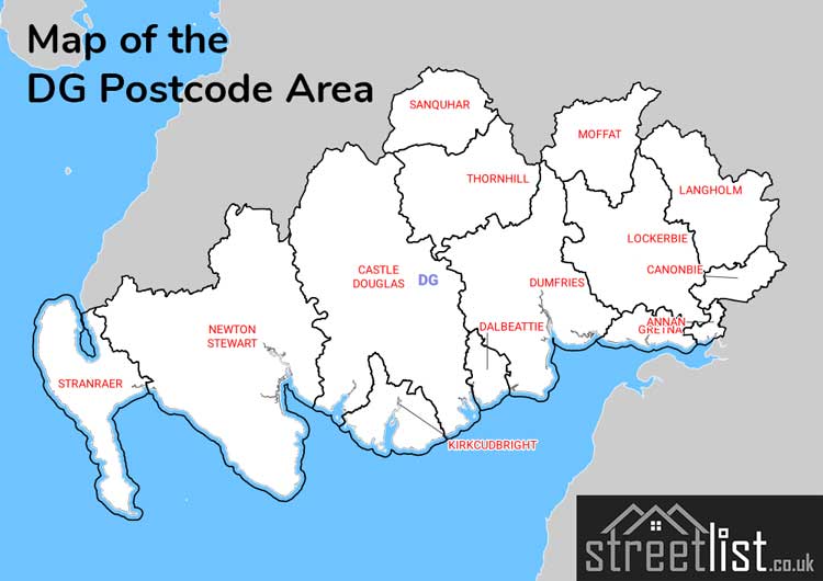
DG Postcode Area for the Dumfries and Galloway Region
A wide range of spatial data has been analysed to present this overview. If you would like anything added, please contact us.
This section of the site is all about the DG Postcode area, also known as the Dumfries and Galloway Postal Area. Explore links to the next level to learn more about specific postcode districts such as DG1.
Map of the DG Dumfries and Galloway Postcode Area
Explore the postcode area by using our interactive map.
Quick Facts about the DG Postcode
| Width from East to West | 93.73 mi |
| Height from North to South | 56.23 mi |
| Area of DG | 829.14 mi² |
| Maximum Width | 94.80 mi |
| Perimeter of Postcode Area | 505.71 mi |
| Number of Postcode Districts | 15 |
| Number of Postcode Sectors | 39 |
| Number of Post Towns | 14 |
| Number of Postcodes | 6,847 |
The DG postcode area represents a group of 15 postal districts in the Dumfries and Galloway area of the United Kingdom. The area code stands for the letters d and g in Dumfries and Galloway. The area has a population of 151,174 and covers an area of 6,479,521 hectares. Fun fact: 0.23% of the population of Great Britain lives in this area.
The postcode area falls within the following counties: Dumfries (58.28%), Wigtown (23.96%), The Stewartry of Kirkcudbright (17.65%), Cumbria (0.07%), Ayrshire and Arran (0.01%), Lanarkshire (0.01%), Roxburgh, Ettrick and Lauderdale (0.01%).
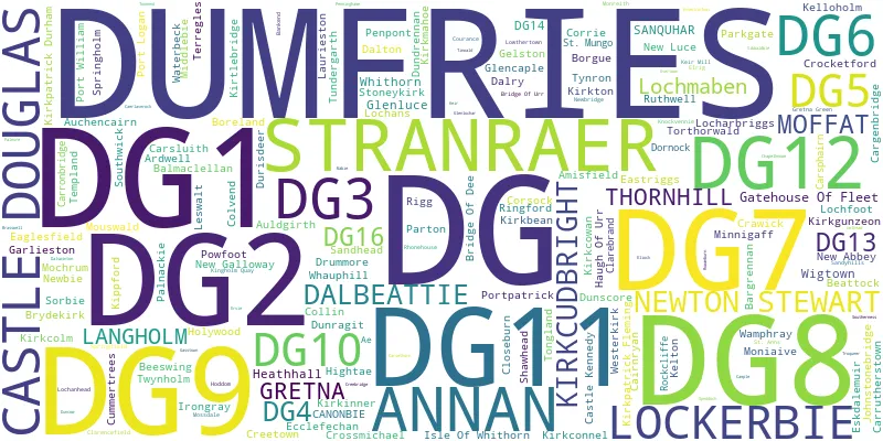
Post Towns and Postcode Districts
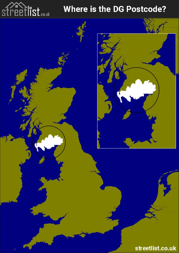
Where is the DG Postcode Area?
The DG Dumfries and Galloway Postcode is in Scotland.. The postal area borders the following neighbouring postal areas: TD - Teviotdale, CA - Carlisle, KA - Kilmarnock and ML - Motherwell, It also borders The Irish Sea, The North Channel and The Solway Firth.
How built up is the Postcode Area?
I've calculated the total area covered by building footprints within the postcode area.
By analyzing this against the total area, I've determined the percentage of the area that's developed, this will give you an idea of how urban or rural the postcode region is.
The higher the percentage the more urban the area is. For example the least urban district is DG13 and the most urban is DG12.
| Postcode District | Total Area (m²) | Footprint Area (m²) | Built Percentage % |
|---|---|---|---|
| DG13 | 432,847,190 | 327,485 | 0.08% |
| DG3 | 485,008,454 | 689,542 | 0.14% |
| DG4 | 271,379,389 | 390,367 | 0.14% |
| DG10 | 312,948,665 | 459,591 | 0.15% |
| DG7 | 1,322,724,581 | 1,949,918 | 0.15% |
| DG8 | 1,374,047,827 | 2,183,270 | 0.16% |
| DG14 | 116,294,246 | 259,606 | 0.22% |
| DG11 | 606,344,342 | 2,266,415 | 0.37% |
| DG6 | 189,372,356 | 804,362 | 0.42% |
| DG2 | 482,882,350 | 2,292,100 | 0.47% |
| DG9 | 373,098,452 | 1,898,154 | 0.51% |
| DG5 | 85,839,638 | 534,402 | 0.62% |
| DG1 | 292,755,397 | 2,412,105 | 0.82% |
| DG16 | 34,040,171 | 418,264 | 1.23% |
| DG12 | 99,417,913 | 1,235,128 | 1.24% |
| Total | 6,479,000,971 (m²) | 18,120,709 (m²) | 0.28% |
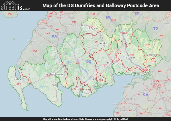
A map showing the boundary of DG in relation to other areas
There are 16 towns within the Dumfries and Galloway postcode area.
| Unit | Area² |
|---|---|
| Hectares | 6,479,521² |
| Miles | 25,018² |
| Feet | 697,449,160,919² |
| Kilometres | 64,795² |
Postal Delivery Offices Serving the Postcode Area
- Annan Delivery Office
- Canonbie Scale Payment Delivery Office
- Castle Douglas Delivery Office
- Dalry (dg) Scale Payment Delivery Office
- Dumfries Delivery Office
- Garlieston Scale Payment Delivery Office
- Gatehouse Of Fleet Scale Payment Delivery Office
- Glenluce Scale Payment Delivery Office
- Gretna Scale Payment Delivery Office
- Kirkconnel Scale Payment Delivery Office
- Kirkcudbright Delivery Office
- Langholm Delivery Office
- Lockerbie Delivery Office
- Moffat Delivery Office
- Newton Stewart Delivery Office
- Port William Scale Payment Delivery Office
- Sanquhar Scale Payment Delivery Office
- Stranraer Delivery Office
- Thornhill Delivery Office
- Whauphill Scale Payment Delivery Office
- Whithorn Scale Payment Delivery Office
- Wigtown Scale Payment Delivery Office
Tourist Attractions within the Area
We found 1 visitor attractions within the Dumfries and Galloway postcode area
| RNLI Station and Museum |
|---|
| Other |
| View RNLI Station and Museum on Google Maps |
Councils with Postcodes the Area
Towns and Villages within the Area
- Ae - village
- Amisfield - village
- Annan - town
- Ardwell - village
- Auchencairn - village
- Auldgirth - village
- Balmaclellan - village
- Beattock - village
- Beeswing - village
- Bladnoch - village
- Bridge of Dee - village
- Brydekirk - village
- Cairnryan - village
- Canonbie - village
- Cargenbridge - village
- Carronbridge - village
- Carrutherstown - village
- Carsethorn - village
- Carsluith - village
- Castle Douglas - town
- Castle Kennedy - village
- Clarencefield - village
- Closeburn - village
- Collin - village
- Colvend - village
- Corsock - village
- Creetown - village
- Crossmichael - village
- Cummertrees - village
- Dalbeattie - town
- Dornock - village
- Drummore - village
- Dumfries - town
- Dundrennan - village
- Dunragit - village
- Dunscore - village
- Eaglesfield -
- Eastriggs - village
- Ecclefechan - village
- Eskdalemuir - village
- Garlieston - village
- Gatehouse of Fleet - town
- Gelston - village
- Glasserton - otherSettlement
- Glencaple - village
- Glenluce - village
- Greenlea - village
- Gretna - village
- Gretna Green - village
- Halleaths - otherSettlement
- Haugh of Urr - village
- Hightae - village
- Holywood - village
- Isle of Whithorn - village
- Johnstonebridge - village
- Kelton Hill / Rhonehouse - village
- Kirkcolm - village
- Kirkconnel - village
- Kirkcowan - village
- Kirkcudbright - town
- Kirkgunzeon - village
- Kirkinner - village
- Kirkland - otherSettlement
- Kirkpatrick Durham - village
- Kirkpatrick-Fleming - village
- Kirkton - village
- Kirtlebridge - village
- Langholm - town
- Laurieston - village
- Leswalt - village
- Lochanhead - otherSettlement
- Lochans - village
- Locharbriggs - village
- Lochfoot - village
- Lochmaben - town
- Lockerbie - town
- Mochrum - village
- Moffat - town
- Moniaive - village
- New Abbey - village
- New Galloway - town
- New Luce - village
- Newbie - village
- Newton Stewart - town
- Ninemile Bar / Crocketford - village
- Palnackie - village
- Park - village
- Parkgate - village
- Penpont - village
- Port Logan - village
- Port William - village
- Portpatrick - village
- Powfoot - village
- Rigg - village
- Rockcliffe - village
- Rowanburn - village
- Sandhead - village
- Sandyhills - village
- Sanquhar - town
- Scaur / Kippford - village
- Shawhead - village
- Sorbie - village
- Southerness - village
- Springfield - village
- Springholm - village
- St John's Town of Dalry - village
- Stoneykirk - village
- Stranraer - town
- Templand - village
- Terregles - village
- Thornhill (Dumfries and Galloway) -
- Tongland - village
- Torthorwald - village
- Twynholm - village
- Waterbeck - village
- Whauphill - village
- Whithorn - town
- Wigtown - town