The DG9 postcode district is a postal district located in the DG Dumfries and Galloway postcode area with a population of 16,349 residents according to the 2011 Scotland Census.
The area of the DG9 postcode district is 144.05 square miles which is 373.10 square kilometres or 92,194.55 acres.
Currently, the DG9 district has about 808 postcode units spread across 4 geographic postcode sectors.
Given that each sector allows for 400 unique postcode combinations, the district has a capacity of 1,600 postcodes. With 808 postcodes already in use, this leaves 792 units available.
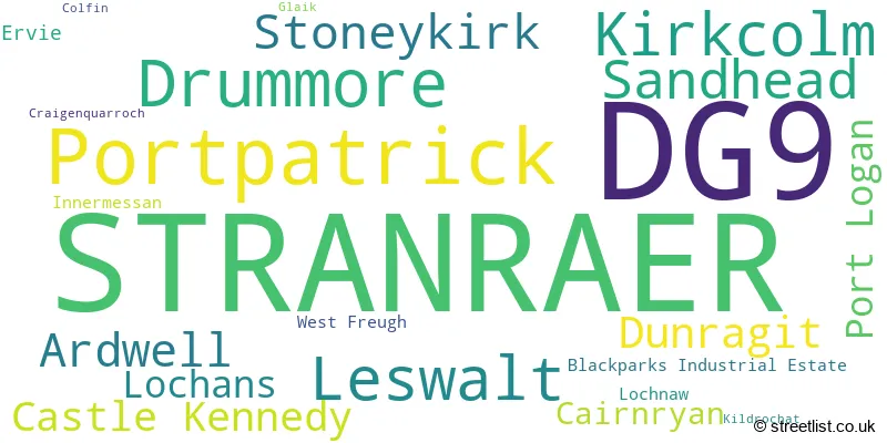
The largest settlement in the DG9 postal code is STRANRAER followed by Portpatrick, and Drummore.
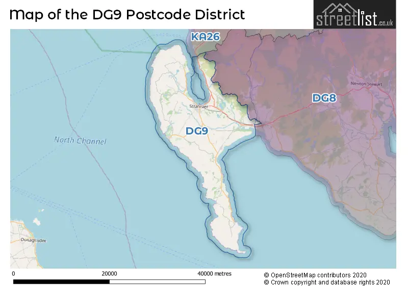
The postcode area has a boundary with North Channel and The Irish Sea.
The DG9 Postcode shares a border with DG8 (NEWTON STEWART, Wigtown, Glenluce).
The primary settlement in the DG9 postcode district is Stranraer, which is located in the county of Wigtown in Scotland. Other significant settlements in this postcode district include Kirkcolm, Leswalt, Lochans, Portpatrick, Ardwell, Drummore, Sandhead, and Stoneykirk. The main post town in this district is also Stranraer.
For the district DG9, we have data on 5 postcode sectors. Here's a breakdown: The sector DG9 0, covers Stranraer and Leswalt and Kirkcolm in Wigtown. The sector DG9 1 is non-geographic. It's often designated for PO Boxes, large organisations, or special services. The sector DG9 7, covers Stranraer in Wigtown. The sector DG9 8, covers Stranraer and Portpatrick in Wigtown. The sector DG9 9, covers Drummore and Sandhead and Stoneykirk and Ardwell and Stranraer in Wigtown.

Map of the DG9 Postcode District
Explore the DG9 postcode district by using our free interactive map.
When it comes to local government, postal geography often disregards political borders. However, for a breakdown in the DG9 District: the district mostly encompasses the Dumfries and Galloway area with a total of 807 postcodes.
Weather Forecast for DG9
Press Button to Show Forecast for West Freugh
| Time Period | Icon | Description | Temperature | Rain Probability | Wind |
|---|---|---|---|---|---|
| 21:00 to 00:00 | Partly cloudy (night) | 5.0°C (feels like 3.0°C) | 1.00% | N 4 mph |
Press Button to Show Forecast for West Freugh
| Time Period | Icon | Description | Temperature | Rain Probability | Wind |
|---|---|---|---|---|---|
| 00:00 to 03:00 | Partly cloudy (night) | 3.0°C (feels like 1.0°C) | 2.00% | NE 4 mph | |
| 03:00 to 06:00 | Clear night | 0.0°C (feels like -2.0°C) | 3.00% | NE 2 mph | |
| 06:00 to 09:00 | Sunny day | 3.0°C (feels like 1.0°C) | 2.00% | NE 2 mph | |
| 09:00 to 12:00 | Partly cloudy (day) | 9.0°C (feels like 8.0°C) | 1.00% | SE 7 mph | |
| 12:00 to 15:00 | Cloudy | 9.0°C (feels like 7.0°C) | 37.00% | SW 9 mph | |
| 15:00 to 18:00 | Cloudy | 10.0°C (feels like 9.0°C) | 9.00% | WNW 7 mph | |
| 18:00 to 21:00 | Partly cloudy (day) | 10.0°C (feels like 8.0°C) | 3.00% | N 7 mph | |
| 21:00 to 00:00 | Partly cloudy (night) | 5.0°C (feels like 3.0°C) | 1.00% | N 4 mph |
Press Button to Show Forecast for West Freugh
| Time Period | Icon | Description | Temperature | Rain Probability | Wind |
|---|---|---|---|---|---|
| 00:00 to 03:00 | Clear night | 4.0°C (feels like 2.0°C) | 0.00% | NE 4 mph | |
| 03:00 to 06:00 | Clear night | 2.0°C (feels like 0.0°C) | 0.00% | NE 2 mph | |
| 06:00 to 09:00 | Sunny day | 4.0°C (feels like 3.0°C) | 0.00% | NNE 2 mph | |
| 09:00 to 12:00 | Partly cloudy (day) | 9.0°C (feels like 8.0°C) | 2.00% | NNW 7 mph | |
| 12:00 to 15:00 | Partly cloudy (day) | 11.0°C (feels like 9.0°C) | 3.00% | WNW 11 mph | |
| 15:00 to 18:00 | Sunny day | 11.0°C (feels like 9.0°C) | 3.00% | W 11 mph | |
| 18:00 to 21:00 | Sunny day | 10.0°C (feels like 7.0°C) | 2.00% | WSW 9 mph | |
| 21:00 to 00:00 | Partly cloudy (night) | 7.0°C (feels like 5.0°C) | 4.00% | SW 9 mph |
Press Button to Show Forecast for West Freugh
| Time Period | Icon | Description | Temperature | Rain Probability | Wind |
|---|---|---|---|---|---|
| 00:00 to 03:00 | Cloudy | 7.0°C (feels like 4.0°C) | 7.00% | S 9 mph | |
| 03:00 to 06:00 | Cloudy | 7.0°C (feels like 4.0°C) | 9.00% | S 9 mph | |
| 06:00 to 09:00 | Cloudy | 8.0°C (feels like 5.0°C) | 13.00% | S 11 mph | |
| 09:00 to 12:00 | Light rain shower (day) | 10.0°C (feels like 6.0°C) | 43.00% | S 18 mph | |
| 12:00 to 15:00 | Light rain | 11.0°C (feels like 7.0°C) | 56.00% | S 22 mph | |
| 15:00 to 18:00 | Light rain | 11.0°C (feels like 8.0°C) | 53.00% | S 22 mph | |
| 18:00 to 21:00 | Light rain | 11.0°C (feels like 7.0°C) | 54.00% | SSE 18 mph | |
| 21:00 to 00:00 | Light rain | 10.0°C (feels like 6.0°C) | 50.00% | SSE 16 mph |
Press Button to Show Forecast for West Freugh
| Time Period | Icon | Description | Temperature | Rain Probability | Wind |
|---|---|---|---|---|---|
| 00:00 to 03:00 | Light rain | 9.0°C (feels like 6.0°C) | 49.00% | SE 13 mph | |
| 03:00 to 06:00 | Light rain shower (night) | 9.0°C (feels like 6.0°C) | 39.00% | SE 13 mph | |
| 06:00 to 09:00 | Light rain | 9.0°C (feels like 6.0°C) | 46.00% | SE 13 mph | |
| 09:00 to 12:00 | Light rain | 11.0°C (feels like 8.0°C) | 45.00% | SE 16 mph | |
| 12:00 to 15:00 | Partly cloudy (day) | 13.0°C (feels like 10.0°C) | 13.00% | SE 18 mph | |
| 15:00 to 18:00 | Cloudy | 14.0°C (feels like 11.0°C) | 12.00% | SE 16 mph | |
| 18:00 to 21:00 | Partly cloudy (day) | 14.0°C (feels like 11.0°C) | 6.00% | ESE 11 mph | |
| 21:00 to 00:00 | Partly cloudy (night) | 11.0°C (feels like 8.0°C) | 4.00% | E 9 mph |
Where is the DG9 Postcode District?
The data shows that the postcode district DG9 is located in the town of Stranraer. Stranraer is a district town in Scotland. It is situated near other towns such as Glasgow, Newton Stewart, and Girvan. Additionally, Stranraer is located approximately 308.1 miles away from the center of London.
The district is within the post town of STRANRAER.
The sector has postcodes within the nation of Scotland.
The DG9 Postcode District is in the Dumfries & Galloway region of Southern Scotland within the Scotland.
Postcode Districts that Share a Border with DG9
| Postcode Sector | Delivery Office |
|---|---|
| DG9 0 | Stranraer Delivery Office |
| DG9 7 | Stranraer Delivery Office |
| DG9 8 | Stranraer Delivery Office |
| DG9 9 | Stranraer Delivery Office |
| D | G | 9 | - | X | X | X |
| D | G | 9 | Space | Numeric | Letter | Letter |
Current Monthly Rental Prices
| # Bedrooms | Min Price | Max Price | Avg Price |
|---|
Current House Prices
| # Bedrooms | Min Price | Max Price | Avg Price |
|---|---|---|---|
| £50,000 | £225,000 | £95,000 | |
| 1 | £75,000 | £75,000 | £75,000 |
| 2 | £120,000 | £250,000 | £157,182 |
| 3 | £150,000 | £250,000 | £193,333 |
| 4 | £85,000 | £650,000 | £354,999 |
| 5 | £250,000 | £620,000 | £380,000 |
| 9 | £9,500,000 | £9,500,000 | £9,500,000 |
Estate Agents who Operate in the DG9 District
| Logo | Name | Brand Name | Address | Contact Number | Total Properties |
|---|---|---|---|---|---|
 | Stranraer | South West Property Centre | Charlotte Street, Stranraer, DG9 7ED | 01776 748739 | 19 |
 | Paisley | Auction House Scotland | Auction House Scotland Office 2 Craigs Business Centre Macdowall Street Paisley Renfrewshire PA3 2NB | 0141 673 7275 | 3 |
 | Castle Douglas | Galbraith | 93 King Street Castle Douglas DG7 1AE | 01556 512041 | 2 |
 | Edinburgh Country | Savills | Wemyss House 8 Wemyss Place Edinburgh EH3 6DH | 0131 381 2387 | 1 |
 | Scotland | Yopa | Meridian House Wheatfield Way Hinckley LE10 1YG | 0161 524 0574 | 1 |