The DG8 postcode district is a postal district located in the DG Dumfries and Galloway postcode area with a population of 12,980 residents according to the 2011 Scotland Census.
The area of the DG8 postcode district is 53.05 square miles which is 137.40 square kilometres or 33,953.43 acres.
Currently, the DG8 district has about 834 postcode units spread across 5 geographic postcode sectors.
Given that each sector allows for 400 unique postcode combinations, the district has a capacity of 2,000 postcodes. With 834 postcodes already in use, this leaves 1166 units available.
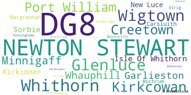
The largest settlement in the DG8 postal code is NEWTON STEWART followed by Wigtown, and Glenluce.
The postcode area has a boundary with Solway Firth and The Irish Sea.
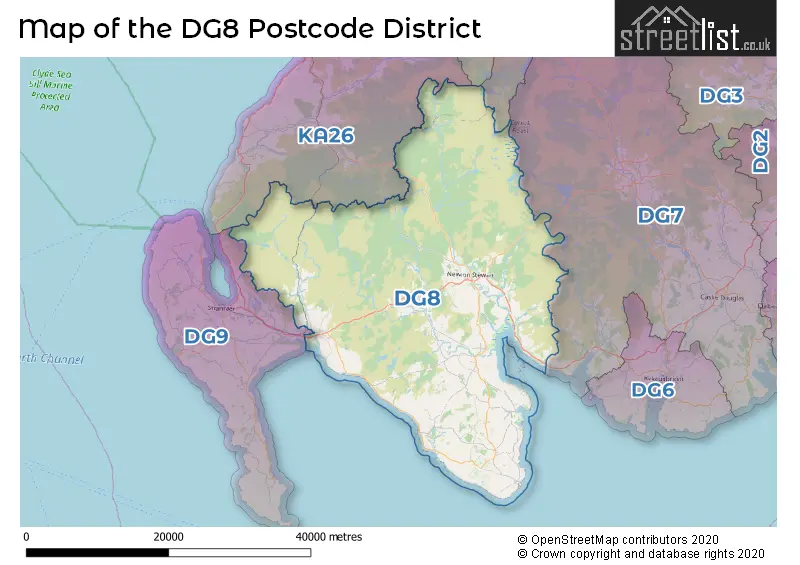
The DG8 Postcode shares a border with DG7 (CASTLE DOUGLAS, Gatehouse Of Fleet, Dalry), KA19 (MAYBOLE, Crosshill, Straiton), KA6 (Dalmellington, Drongan, Coylton), DG9 (STRANRAER, Portpatrick, Drummore) and KA26 (GIRVAN, Dailly, Ballantrae).
The primary settlement in the DG8 postcode district is Newton Stewart, located in the county of Wigtown in Scotland. Other significant settlements within this district include Glenluce, Kirkcowan, New Luce, Bargrennan, Barvennan, Carty, Challoch, Creebridge, Glentrool, Knowe, Minnigaff, Old Minnigaff, Penninghame, Blackcraig, Carsluith, Creetown, Palnure, Garlieston, Isle of Whithorn, Monreith, Sorbie, Whithorn, Elrig, Kirkinner, Mochrum, Port William, Whauphill, and Wigtown. The most significant post town in this district is Newton Stewart.
For the district DG8, we have data on 5 postcode sectors. Here's a breakdown: The sector DG8 0, covers Glenluce and Kirkcowan and New Luce in Wigtown. The sector DG8 6, covers Newton Stewart and Minnigaff in Wigtown. The sector DG8 7, covers Creetown and Newton Stewart and Carsluith in Wigtown. The sector DG8 8, covers Whithorn and Garlieston and Isle Of Whithorn and Sorbie in Wigtown. The sector DG8 9, covers Wigtown and Port William and Whauphill in Wigtown.

Map of the DG8 Postcode District
Explore the DG8 postcode district by using our free interactive map.
When it comes to local government, postal geography often disregards political borders. However, for a breakdown in the DG8 District: the district mostly encompasses the Dumfries and Galloway area with a total of 832 postcodes.
Where is the DG8 Postcode District?
The data you provided indicates that the postcode district DG8 is located in Newton Stewart, a district town. Newton Stewart is situated in the South of Scotland. It is surrounded by several nearby towns, including Glasgow to the South (11.36 miles away), Stranraer to the West (18.30 miles away), Girvan to the North (22.12 miles away), and Kirkcudbright to the East (23.26 miles away). In addition, the distance between Newton Stewart and the centre of London is approximately 300.97 miles.
The district is within the post town of NEWTON STEWART.
The sector has postcodes within the nation of Scotland.
The DG8 Postcode District is covers the following regions.
- Dumfries & Galloway - Southern Scotland - Scotland
- South Ayrshire - Southern Scotland - Scotland
Weather Forecast for DG8
Press Button to Show Forecast for Kirkcowan
| Time Period | Icon | Description | Temperature | Rain Probability | Wind |
|---|---|---|---|---|---|
| 21:00 to 00:00 | Cloudy | 11.0°C (feels like 11.0°C) | 8.00% | S 2 mph |
Press Button to Show Forecast for Kirkcowan
| Time Period | Icon | Description | Temperature | Rain Probability | Wind |
|---|---|---|---|---|---|
| 00:00 to 03:00 | Light rain | 11.0°C (feels like 11.0°C) | 42.00% | SSE 2 mph | |
| 03:00 to 06:00 | Cloudy | 10.0°C (feels like 10.0°C) | 6.00% | SSE 2 mph | |
| 06:00 to 09:00 | Mist | 11.0°C (feels like 11.0°C) | 12.00% | S 2 mph | |
| 09:00 to 12:00 | Overcast | 14.0°C (feels like 13.0°C) | 8.00% | SSW 4 mph | |
| 12:00 to 15:00 | Cloudy | 16.0°C (feels like 15.0°C) | 8.00% | SSW 7 mph | |
| 15:00 to 18:00 | Cloudy | 15.0°C (feels like 14.0°C) | 4.00% | SSW 7 mph | |
| 18:00 to 21:00 | Cloudy | 14.0°C (feels like 13.0°C) | 6.00% | SSW 7 mph | |
| 21:00 to 00:00 | Cloudy | 11.0°C (feels like 11.0°C) | 6.00% | SSE 2 mph |
Press Button to Show Forecast for Kirkcowan
| Time Period | Icon | Description | Temperature | Rain Probability | Wind |
|---|---|---|---|---|---|
| 00:00 to 03:00 | Cloudy | 10.0°C (feels like 10.0°C) | 7.00% | ESE 2 mph | |
| 03:00 to 06:00 | Cloudy | 10.0°C (feels like 9.0°C) | 8.00% | ESE 4 mph | |
| 06:00 to 09:00 | Cloudy | 11.0°C (feels like 10.0°C) | 5.00% | ESE 4 mph | |
| 09:00 to 12:00 | Cloudy | 14.0°C (feels like 13.0°C) | 4.00% | SE 7 mph | |
| 12:00 to 15:00 | Partly cloudy (day) | 17.0°C (feels like 16.0°C) | 1.00% | SSE 7 mph | |
| 15:00 to 18:00 | Partly cloudy (day) | 18.0°C (feels like 16.0°C) | 1.00% | S 9 mph | |
| 18:00 to 21:00 | Sunny day | 16.0°C (feels like 15.0°C) | 0.00% | SSE 7 mph | |
| 21:00 to 00:00 | Clear night | 12.0°C (feels like 11.0°C) | 1.00% | SE 4 mph |
Press Button to Show Forecast for Kirkcowan
| Time Period | Icon | Description | Temperature | Rain Probability | Wind |
|---|---|---|---|---|---|
| 00:00 to 03:00 | Partly cloudy (night) | 11.0°C (feels like 10.0°C) | 2.00% | SE 4 mph | |
| 03:00 to 06:00 | Partly cloudy (night) | 10.0°C (feels like 9.0°C) | 1.00% | SE 4 mph | |
| 06:00 to 09:00 | Partly cloudy (day) | 12.0°C (feels like 11.0°C) | 1.00% | SE 7 mph | |
| 09:00 to 12:00 | Partly cloudy (day) | 16.0°C (feels like 15.0°C) | 1.00% | SSE 9 mph | |
| 12:00 to 15:00 | Sunny day | 18.0°C (feels like 16.0°C) | 1.00% | SSE 9 mph | |
| 15:00 to 18:00 | Sunny day | 19.0°C (feels like 17.0°C) | 1.00% | SSE 11 mph | |
| 18:00 to 21:00 | Sunny day | 17.0°C (feels like 16.0°C) | 3.00% | SSE 9 mph | |
| 21:00 to 00:00 | Partly cloudy (night) | 14.0°C (feels like 13.0°C) | 2.00% | SE 7 mph |
Press Button to Show Forecast for Kirkcowan
| Time Period | Icon | Description | Temperature | Rain Probability | Wind |
|---|---|---|---|---|---|
| 00:00 to 03:00 | Partly cloudy (night) | 13.0°C (feels like 12.0°C) | 3.00% | SE 7 mph | |
| 03:00 to 06:00 | Partly cloudy (night) | 12.0°C (feels like 11.0°C) | 3.00% | SE 7 mph | |
| 06:00 to 09:00 | Cloudy | 14.0°C (feels like 12.0°C) | 7.00% | SE 9 mph | |
| 09:00 to 12:00 | Cloudy | 16.0°C (feels like 14.0°C) | 9.00% | SSE 11 mph | |
| 12:00 to 15:00 | Cloudy | 18.0°C (feels like 16.0°C) | 12.00% | SSE 11 mph | |
| 15:00 to 18:00 | Cloudy | 18.0°C (feels like 16.0°C) | 11.00% | SSE 11 mph | |
| 18:00 to 21:00 | Cloudy | 17.0°C (feels like 16.0°C) | 12.00% | SSE 7 mph | |
| 21:00 to 00:00 | Cloudy | 14.0°C (feels like 13.0°C) | 13.00% | SW 7 mph |
| Postcode Sector | Delivery Office |
|---|---|
| DG8 0 | Newton Stewart Delivery Office |
| DG8 0 | Port William Scale Payment Delivery Office |
| DG8 0 | Glenluce Scale Payment Delivery Office |
| DG8 6 | Port William Scale Payment Delivery Office |
| DG8 6 | Whauphill Scale Payment Delivery Office |
| DG8 6 | Glenluce Scale Payment Delivery Office |
| DG8 6 | Newton Stewart Delivery Office |
| DG8 7 | Newton Stewart Delivery Office |
| DG8 8 | Newton Stewart Delivery Office |
| DG8 8 | Garlieston Scale Payment Delivery Office |
| DG8 8 | Whithorn Scale Payment Delivery Office |
| DG8 9 | Newton Stewart Delivery Office |
| DG8 9 | Whithorn Scale Payment Delivery Office |
| DG8 9 | Port William Scale Payment Delivery Office |
| DG8 9 | Whauphill Scale Payment Delivery Office |
| DG8 9 | Wigtown Scale Payment Delivery Office |
| D | G | 8 | - | X | X | X |
| D | G | 8 | Space | Numeric | Letter | Letter |
Current Monthly Rental Prices
| # Bedrooms | Min Price | Max Price | Avg Price |
|---|---|---|---|
| 1 | £806 | £806 | £806 |
Current House Prices
| # Bedrooms | Min Price | Max Price | Avg Price |
|---|---|---|---|
| £29,000 | £2,150,000 | £806,619 | |
| 2 | £19,500 | £300,000 | £106,728 |
| 3 | £90,000 | £950,000 | £294,615 |
| 4 | £170,000 | £1,850,000 | £467,490 |
| 5 | £290,000 | £495,000 | £375,000 |
| 6 | £9,500,000 | £9,500,000 | £9,500,000 |
| 7 | £775,000 | £990,000 | £882,500 |
| 8 | £395,000 | £395,000 | £395,000 |
Estate Agents who Operate in the DG8 District
| Logo | Name | Brand Name | Address | Contact Number | Total Properties |
|---|---|---|---|---|---|
 | Castle Douglas | Galbraith | 93 King Street Castle Douglas DG7 1AE | 01556 512041 | 9 |
 | Stranraer | South West Property Centre | Charlotte Street, Stranraer, DG9 7ED | 01776 748739 | 8 |
 | Lytham | Sell My Group | The Old Bakery Green Street, Lytham, Lytham St. Annes, FY8 5LG | 020 3910 6164 | 6 |
 | Riccarton | Davidson & Robertson Limited | The Rural Centre West Mains Ingliston Edinburgh EH28 8LT | 01308 800946 | 6 |
 | Kirkcudbright | Williamson & Henry | 3 St. Cuthbert Street Kirkcudbright DG6 4DJ | 01557 520288 | 6 |