The DG5 postcode district is a postal district located in the DG Dumfries and Galloway postcode area with a population of 5,311 residents according to the 2011 Scotland Census.
The area of the DG5 postcode district is 33.14 square miles which is 85.84 square kilometres or 21,211.42 acres.
Currently, the DG5 district has about 215 postcode units spread across 1 geographic postcode sectors.
Given that each sector allows for 400 unique postcode combinations, the district has a capacity of 400 postcodes. With 215 postcodes already in use, this leaves 185 units available.
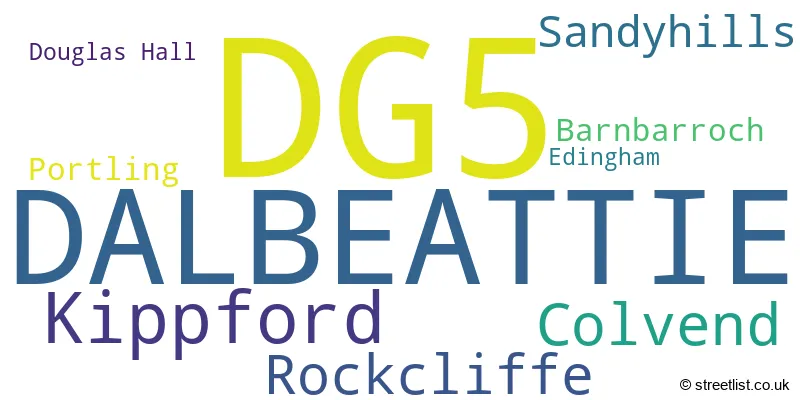
The largest settlement in the DG5 postal code is DALBEATTIE followed by Kippford, and Rockcliffe.
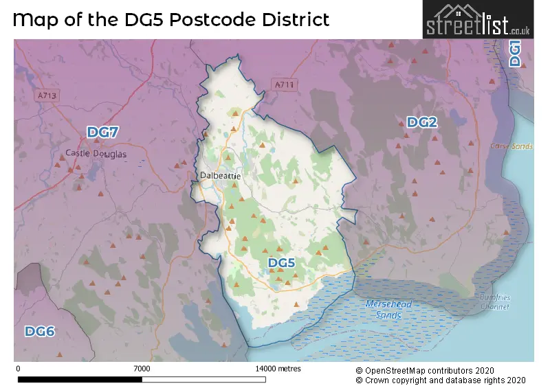
The postcode area has a boundary with Solway Firth.
The DG5 Postcode shares a border with DG7 (CASTLE DOUGLAS, Gatehouse Of Fleet, Dalry) and DG2 (DUMFRIES, Southerness, Auldgirth).
The primary settlement in the DG5 postcode district is Dalbeattie, which is located in the Stewartry of Kirkcudbright in Scotland. Other significant settlements in this postcode district include Barnbarroch, Colvend, Douglas Hall, Edingham, Kippford, Portling, Rockcliffe, and Sandyhills. The most significant Postal Town within this district is Dalbeattie.
For the district DG5, we have data on 1 postcode sectors. Here's a breakdown: The sector DG5 4, covers Dalbeattie in The Stewartry of Kirkcudbright.
DG5 Postcode Sectors

Map of the DG5 Postcode District
Explore the DG5 postcode district by using our free interactive map.
When it comes to local government, postal geography often disregards political borders. However, for a breakdown in the DG5 District: the district mostly encompasses the Dumfries and Galloway area with a total of 215 postcodes.
Where is the DG5 Postcode District?
The postcode district DG5 is located in Dalbeattie. Dalbeattie is a district town in Scotland. It is nearby several towns, with Castle Douglas situated to the North West, Kirkcudbright to the South West, Dumfries to the North East, Maryport to the South East, and Annan to the East. The distance from DG5 to the center of London is 280.2 miles.
The district is within the post town of DALBEATTIE.
The sector has postcodes within the nation of Scotland.
The DG5 Postcode District is in the Dumfries & Galloway region of Southern Scotland within the Scotland.
Weather Forecast for DG5
Press Button to Show Forecast for Dalbeattie Mountain Bike Trail Centre
| Time Period | Icon | Description | Temperature | Rain Probability | Wind |
|---|---|---|---|---|---|
| 09:00 to 12:00 | Sunny day | 19.0°C (feels like 19.0°C) | 0.00% | ESE 2 mph | |
| 12:00 to 15:00 | Partly cloudy (day) | 21.0°C (feels like 20.0°C) | 2.00% | S 7 mph | |
| 15:00 to 18:00 | Cloudy | 20.0°C (feels like 19.0°C) | 3.00% | S 7 mph | |
| 18:00 to 21:00 | Cloudy | 19.0°C (feels like 19.0°C) | 4.00% | SSE 4 mph | |
| 21:00 to 00:00 | Cloudy | 15.0°C (feels like 15.0°C) | 3.00% | ENE 2 mph |
Press Button to Show Forecast for Dalbeattie Mountain Bike Trail Centre
| Time Period | Icon | Description | Temperature | Rain Probability | Wind |
|---|---|---|---|---|---|
| 00:00 to 03:00 | Cloudy | 14.0°C (feels like 14.0°C) | 4.00% | SE 4 mph | |
| 03:00 to 06:00 | Cloudy | 14.0°C (feels like 13.0°C) | 5.00% | ENE 4 mph | |
| 06:00 to 09:00 | Cloudy | 14.0°C (feels like 14.0°C) | 5.00% | ENE 4 mph | |
| 09:00 to 12:00 | Cloudy | 18.0°C (feels like 17.0°C) | 4.00% | ESE 4 mph | |
| 12:00 to 15:00 | Cloudy | 21.0°C (feels like 20.0°C) | 5.00% | SSE 7 mph | |
| 15:00 to 18:00 | Light rain shower (day) | 20.0°C (feels like 19.0°C) | 27.00% | SSE 7 mph | |
| 18:00 to 21:00 | Cloudy | 18.0°C (feels like 17.0°C) | 61.00% | SSE 7 mph | |
| 21:00 to 00:00 | Heavy rain shower (night) | 15.0°C (feels like 14.0°C) | 69.00% | SE 7 mph |
Press Button to Show Forecast for Dalbeattie Mountain Bike Trail Centre
| Time Period | Icon | Description | Temperature | Rain Probability | Wind |
|---|---|---|---|---|---|
| 00:00 to 03:00 | Light rain shower (night) | 14.0°C (feels like 14.0°C) | 48.00% | E 4 mph | |
| 03:00 to 06:00 | Heavy rain shower (night) | 13.0°C (feels like 13.0°C) | 59.00% | SE 4 mph | |
| 06:00 to 09:00 | Light rain shower (day) | 13.0°C (feels like 12.0°C) | 37.00% | SE 4 mph | |
| 09:00 to 12:00 | Cloudy | 14.0°C (feels like 13.0°C) | 15.00% | SSE 7 mph | |
| 12:00 to 15:00 | Light rain shower (day) | 15.0°C (feels like 15.0°C) | 36.00% | S 7 mph | |
| 15:00 to 18:00 | Cloudy | 16.0°C (feels like 15.0°C) | 24.00% | S 7 mph | |
| 18:00 to 21:00 | Cloudy | 15.0°C (feels like 14.0°C) | 29.00% | ESE 4 mph | |
| 21:00 to 00:00 | Light rain | 14.0°C (feels like 13.0°C) | 63.00% | ESE 7 mph |
Press Button to Show Forecast for Dalbeattie Mountain Bike Trail Centre
| Time Period | Icon | Description | Temperature | Rain Probability | Wind |
|---|---|---|---|---|---|
| 00:00 to 03:00 | Heavy rain | 13.0°C (feels like 12.0°C) | 85.00% | ESE 9 mph | |
| 03:00 to 06:00 | Heavy rain | 13.0°C (feels like 12.0°C) | 82.00% | ESE 9 mph | |
| 06:00 to 09:00 | Light rain | 13.0°C (feels like 12.0°C) | 56.00% | SE 7 mph | |
| 09:00 to 12:00 | Light rain | 14.0°C (feels like 13.0°C) | 54.00% | SE 9 mph | |
| 12:00 to 15:00 | Light rain shower (day) | 15.0°C (feels like 14.0°C) | 40.00% | SE 9 mph | |
| 15:00 to 18:00 | Light rain shower (day) | 16.0°C (feels like 15.0°C) | 38.00% | SE 7 mph | |
| 18:00 to 21:00 | Light rain shower (day) | 15.0°C (feels like 14.0°C) | 37.00% | SE 7 mph | |
| 21:00 to 00:00 | Partly cloudy (night) | 12.0°C (feels like 12.0°C) | 12.00% | ESE 7 mph |
Press Button to Show Forecast for Dalbeattie Mountain Bike Trail Centre
| Time Period | Icon | Description | Temperature | Rain Probability | Wind |
|---|---|---|---|---|---|
| 00:00 to 03:00 | Partly cloudy (night) | 12.0°C (feels like 10.0°C) | 9.00% | ESE 7 mph | |
| 03:00 to 06:00 | Partly cloudy (night) | 11.0°C (feels like 9.0°C) | 10.00% | SE 7 mph | |
| 06:00 to 09:00 | Partly cloudy (day) | 12.0°C (feels like 10.0°C) | 6.00% | SE 9 mph | |
| 09:00 to 12:00 | Partly cloudy (day) | 14.0°C (feels like 12.0°C) | 13.00% | SSE 11 mph | |
| 12:00 to 15:00 | Light rain shower (day) | 15.0°C (feels like 14.0°C) | 35.00% | SSE 11 mph | |
| 15:00 to 18:00 | Light rain shower (day) | 16.0°C (feels like 15.0°C) | 34.00% | SSE 9 mph | |
| 18:00 to 21:00 | Light rain shower (day) | 15.0°C (feels like 14.0°C) | 33.00% | SSE 7 mph | |
| 21:00 to 00:00 | Light rain shower (night) | 12.0°C (feels like 11.0°C) | 25.00% | SE 7 mph |
Postcode Sectors within the DG5 District
| Postcode Sector | Delivery Office |
|---|---|
| DG5 4 | Castle Douglas Delivery Office |
| D | G | 5 | - | X | X | X |
| D | G | 5 | Space | Numeric | Letter | Letter |
Current Monthly Rental Prices
| # Bedrooms | Min Price | Max Price | Avg Price |
|---|
Current House Prices
| # Bedrooms | Min Price | Max Price | Avg Price |
|---|---|---|---|
| £85,000 | £170,000 | £127,500 | |
| 1 | £140,000 | £140,000 | £140,000 |
| 2 | £480,000 | £480,000 | £480,000 |
| 3 | £80,000 | £495,000 | £216,429 |
| 4 | £180,000 | £800,000 | £514,167 |
| 5 | £470,000 | £470,000 | £470,000 |
| 6 | £789,000 | £789,000 | £789,000 |
Estate Agents who Operate in the DG5 District
| Logo | Name | Brand Name | Address | Contact Number | Total Properties |
|---|---|---|---|---|---|
 | Scotland | Yopa | Meridian House Wheatfield Way Hinckley LE10 1YG | 0161 524 0574 | 16 |
 | Castle Douglas | Galbraith | 93 King Street Castle Douglas DG7 1AE | 01556 512041 | 3 |
 | Ayr | Corum | 14 Beresford Terrace, Ayr, KA7 2EG | 01292 431247 | 2 |
 | Dumfries | YOUR MOVE | 2 Queensberry Street, Dumfries, DG1 1EX | 01387 213713 | 2 |
 | Nationwide | Quicklister | 16 - 18 High Street, Kingston Upon Thames, KT1 1EY | 020 3910 6577 | 2 |