The DH9 7 postcode sector is within the county of Durham.
Did you know? According to the 2021 Census, the DH9 7 postcode sector is home to a bustling 8,190 residents!
Given that each sector allows for 400 unique postcode combinations. Letters C, I, K, M, O and V are not allowed in the last two letters of a postcode. With 253 postcodes already in use, this leaves 147 units available.
The largest settlement in the DH9 7 postal code is STANLEY followed by Annfield Plain, and South Moor.
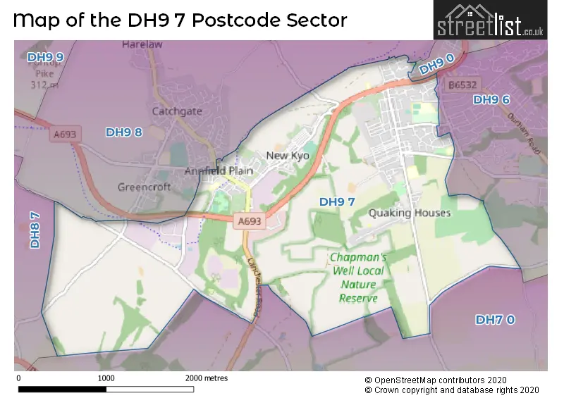
The DH9 7 Postcode shares a border with DH7 0 (Lanchester, Burnhope), DH9 0 (STANLEY, Beamish), DH9 8 (STANLEY, Greencroft, Catchgate), DH8 7 (CONSETT, Leadgate, Crookhall) and DH9 6 (STANLEY, Craghead, West Pelton).
The sector is within the post town of STANLEY.
DH9 7 is a postcode sector within the DH9 postcode district which is within the DH Durham postcode area.
The Royal Mail delivery office for the DH9 7 postal sector is the Derwentside Delivery Office.
The area of the DH9 7 postcode sector is 3.83 square miles which is 9.91 square kilometres or 2,448.56 square acres.

Map of the DH9 7 Postcode Sector
Explore the DH9 7 postcode sector by using our free interactive map.
| D | H | 9 | - | 7 | X | X |
| D | H | 9 | Space | 7 | Letter | Letter |
Official List of Streets
STANLEY (125 Streets)
Greencroft Industrial Park (3 Streets)
South Moor (9 Streets)
Annfield Plain (15 Streets)
New Kyo (7 Streets)
Oxhill (1 Streets)
Quaking Houses (1 Streets)
Greencroft (1 Streets)
Unofficial Streets or Alternative Spellings
STANLEY
FRONT STREET KYO LANE WAGTAIL LANEAnnfield Plain
HUTTON COURTLanchester
LANCHESTER ROADWeather Forecast for DH9 7
Press Button to Show Forecast for Annfield Plain
| Time Period | Icon | Description | Temperature | Rain Probability | Wind |
|---|---|---|---|---|---|
| 15:00 to 18:00 | Cloudy | 20.0°C (feels like 18.0°C) | 3.00% | SSE 11 mph | |
| 18:00 to 21:00 | Cloudy | 18.0°C (feels like 16.0°C) | 3.00% | SE 9 mph | |
| 21:00 to 00:00 | Cloudy | 14.0°C (feels like 12.0°C) | 3.00% | SSE 9 mph |
Press Button to Show Forecast for Annfield Plain
| Time Period | Icon | Description | Temperature | Rain Probability | Wind |
|---|---|---|---|---|---|
| 00:00 to 03:00 | Cloudy | 11.0°C (feels like 9.0°C) | 3.00% | S 9 mph | |
| 03:00 to 06:00 | Cloudy | 10.0°C (feels like 7.0°C) | 3.00% | S 9 mph | |
| 06:00 to 09:00 | Cloudy | 10.0°C (feels like 8.0°C) | 4.00% | S 9 mph | |
| 09:00 to 12:00 | Cloudy | 14.0°C (feels like 13.0°C) | 3.00% | SSE 9 mph | |
| 12:00 to 15:00 | Cloudy | 18.0°C (feels like 16.0°C) | 3.00% | ESE 11 mph | |
| 15:00 to 18:00 | Cloudy | 18.0°C (feels like 16.0°C) | 5.00% | ESE 13 mph | |
| 18:00 to 21:00 | Partly cloudy (day) | 16.0°C (feels like 15.0°C) | 3.00% | SE 9 mph | |
| 21:00 to 00:00 | Cloudy | 13.0°C (feels like 12.0°C) | 6.00% | SE 7 mph |
Press Button to Show Forecast for Annfield Plain
| Time Period | Icon | Description | Temperature | Rain Probability | Wind |
|---|---|---|---|---|---|
| 00:00 to 03:00 | Partly cloudy (night) | 11.0°C (feels like 10.0°C) | 4.00% | ESE 4 mph | |
| 03:00 to 06:00 | Partly cloudy (night) | 10.0°C (feels like 9.0°C) | 5.00% | SE 4 mph | |
| 06:00 to 09:00 | Cloudy | 12.0°C (feels like 11.0°C) | 10.00% | SSE 7 mph | |
| 09:00 to 12:00 | Cloudy | 15.0°C (feels like 13.0°C) | 9.00% | SSE 9 mph | |
| 12:00 to 15:00 | Cloudy | 17.0°C (feels like 15.0°C) | 14.00% | SSE 11 mph | |
| 15:00 to 18:00 | Light rain shower (day) | 17.0°C (feels like 15.0°C) | 36.00% | SSE 13 mph | |
| 18:00 to 21:00 | Cloudy | 16.0°C (feels like 14.0°C) | 16.00% | SSE 11 mph | |
| 21:00 to 00:00 | Cloudy | 14.0°C (feels like 12.0°C) | 22.00% | SSE 9 mph |
Press Button to Show Forecast for Annfield Plain
| Time Period | Icon | Description | Temperature | Rain Probability | Wind |
|---|---|---|---|---|---|
| 00:00 to 03:00 | Overcast | 13.0°C (feels like 11.0°C) | 26.00% | SE 11 mph | |
| 03:00 to 06:00 | Light rain | 12.0°C (feels like 10.0°C) | 58.00% | SE 11 mph | |
| 06:00 to 09:00 | Light rain | 12.0°C (feels like 10.0°C) | 53.00% | SE 9 mph | |
| 09:00 to 12:00 | Light rain | 13.0°C (feels like 11.0°C) | 50.00% | SE 11 mph | |
| 12:00 to 15:00 | Light rain | 14.0°C (feels like 12.0°C) | 52.00% | SE 11 mph | |
| 15:00 to 18:00 | Light rain shower (day) | 14.0°C (feels like 12.0°C) | 41.00% | SE 11 mph | |
| 18:00 to 21:00 | Cloudy | 14.0°C (feels like 12.0°C) | 19.00% | SE 9 mph | |
| 21:00 to 00:00 | Partly cloudy (night) | 12.0°C (feels like 10.0°C) | 7.00% | SE 7 mph |
Press Button to Show Forecast for Annfield Plain
| Time Period | Icon | Description | Temperature | Rain Probability | Wind |
|---|---|---|---|---|---|
| 00:00 to 03:00 | Clear night | 10.0°C (feels like 9.0°C) | 4.00% | SSE 7 mph | |
| 03:00 to 06:00 | Partly cloudy (night) | 9.0°C (feels like 8.0°C) | 3.00% | SSE 7 mph | |
| 06:00 to 09:00 | Cloudy | 10.0°C (feels like 9.0°C) | 7.00% | SSE 9 mph | |
| 09:00 to 12:00 | Cloudy | 13.0°C (feels like 11.0°C) | 9.00% | SSE 11 mph | |
| 12:00 to 15:00 | Light rain shower (day) | 15.0°C (feels like 12.0°C) | 34.00% | SSE 13 mph | |
| 15:00 to 18:00 | Light rain shower (day) | 15.0°C (feels like 13.0°C) | 33.00% | SSE 11 mph | |
| 18:00 to 21:00 | Light rain shower (day) | 13.0°C (feels like 12.0°C) | 31.00% | SE 9 mph | |
| 21:00 to 00:00 | Partly cloudy (night) | 11.0°C (feels like 9.0°C) | 4.00% | SE 7 mph |
Schools and Places of Education Within the DH9 7 Postcode Sector
Annfield Plain Junior School
Academy converter
Front Street, Stanley, County Durham, DH9 7ST
Head: Mrs Inez Burgess
Ofsted Rating: Good
Inspection: 2023-10-13 (211 days ago)
Website: Visit Annfield Plain Junior School Website
Phone: 01207234531
Number of Pupils: 120
Greenland Community Primary School
Academy converter
South Moor Road, Stanley, County Durham, DH9 7EZ
Head: Mr Mark Stewart
Ofsted Rating: Good
Inspection: 2019-11-13 (1641 days ago)
Website: Visit Greenland Community Primary School Website
Phone: 01207232147
Number of Pupils: 331
Oxhill Nursery School
Local authority nursery school
Oxhill, Stanley, County Durham, DH9 7LR
Head: Miss Julia Watson
Ofsted Rating: Good
Inspection: 2019-02-28 (1899 days ago)
Website: Visit Oxhill Nursery School Website
Phone: 01207232266
Number of Pupils: 113
House Prices in the DH9 7 Postcode Sector
| Type of Property | 2018 Average | 2018 Sales | 2017 Average | 2017 Sales | 2016 Average | 2016 Sales | 2015 Average | 2015 Sales |
|---|---|---|---|---|---|---|---|---|
| Detached | £140,027 | 18 | £148,873 | 10 | £151,930 | 23 | £136,116 | 27 |
| Semi-Detached | £94,243 | 32 | £89,114 | 26 | £92,661 | 24 | £97,768 | 16 |
| Terraced | £50,853 | 100 | £51,659 | 121 | £49,963 | 113 | £47,708 | 107 |
| Flats | £28,000 | 2 | £36,000 | 2 | £0 | 0 | £0 | 0 |
Important Postcodes DH9 7 in the Postcode Sector
DH9 7BF is the postcode for The Greencroft Centre, 1 Woodland Court
DH9 7EZ is the postcode for Greenland Community Primary School, South Moor Road, and GREENLAND COMMUNITY PRIMARY, SOUTH MOOR ROAD, DURHAM
DH9 7LR is the postcode for Oxhill Nursery School, Oxhill
DH9 7QN is the postcode for South Moor Greenland Community Junior School, School Terrace, and JUNIOR BLOCK, South Moor Greenland Community Junior School, School Terrace
DH9 7ST is the postcode for UPPER SCHOOL, Annfield Plain Junior School, Annfield Plain, and LOWER SCHOOL, Annfield Plain Junior School, Annfield Plain
DH9 7UY is the postcode for Annfield Plain Infant School, Northgate
DH9 7UZ is the postcode for Manor House, Station Road
DH9 7XN is the postcode for The Greenhouse, Greencroft Industrial Estate
DH9 7XW is the postcode for Morrison Busty Depot Direct Service Organisation, Morrison Busty Depot
| The DH9 7 Sector is within these Local Authorities |
|
|---|---|
| The DH9 7 Sector is within these Counties |
|
| The DH9 7 Sector is within these Water Company Areas |
|