The DL12 9 postcode sector lies where the three counties of Cumbria, Durham, and North Yorkshire meet.
Did you know? According to the 2021 Census, the DL12 9 postcode sector is home to a bustling 3,204 residents!
Given that each sector allows for 400 unique postcode combinations. Letters C, I, K, M, O and V are not allowed in the last two letters of a postcode. With 234 postcodes already in use, this leaves 166 units available.
The largest settlement in the DL12 9 postal code is BARNARD CASTLE followed by Bowes, and Cotherstone.
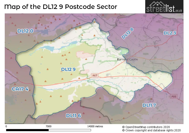
The DL12 9 Postcode shares a border with CA17 4 (KIRKBY STEPHEN, Brough, Ravenstonedale), DL11 7 (Hurst, Aldbrough St. John, Barningham), DL12 0 (Middleton-in-Teesdale, Eggleston, Mickleton), DL12 8 (BARNARD CASTLE, Stainton Grove, Marwood) and DL11 6 (Reeth, Low Row, Ellerton Abbey).
The sector is within the post town of BARNARD CASTLE.
DL12 9 is a postcode sector within the DL12 postcode district which is within the DL Darlington postcode area.
The Royal Mail delivery office for the DL12 9 postal sector is the Barnard Castle Delivery Office.
The area of the DL12 9 postcode sector is 79.43 square miles which is 205.73 square kilometres or 50,836.33 square acres.
The DL12 9 postcode sector is crossed by the A66 Major A road.
Waterways within the DL12 9 postcode sector include the River Tees, Percy Beck, River Greta, Manyfold Beck, Ease Gill, White Stone Gill, Sleightholme Beck, Gill Beck, Gregory Beck, Eller Beck, Polly Gutter, Burnt Gill, Rea Gill, Ay Gill, Rove Gill, Tutta Beck, River Balder, Balder Beck, Black Beck, Deepdale Beck, Wilden Beck.

Map of the DL12 9 Postcode Sector
Explore the DL12 9 postcode sector by using our free interactive map.
| D | L | 1 | 2 | - | 9 | X | X |
| D | L | 1 | 2 | Space | 9 | Letter | Letter |
Official List of Streets
BARNARD CASTLE (21 Streets)
Bowes (10 Streets)
Cotherstone (14 Streets)
Startforth (11 Streets)
Gilmonby (1 Streets)
Romaldkirk (3 Streets)
Boldron (2 Streets)
Greta Bridge (1 Streets)
Unofficial Streets or Alternative Spellings
BARNARD CASTLE
BRIDGEGATE MONTALBO ROAD BLACKTON BRIDGE BOTANY ROAD BRIGNALL LANE BRISCOE LANE BROADMIRES LANE CHAPEL LANE COLLIERY CAUSEWAY COLLINGWOOD BANK CROFT YOKE LANE DAIRY BRIDGE DARK LANE DEEPDALE AQUEDUCT DEMESNE LANE EGGLESTON BRIDGE EGGLESTON LANE FELL LANE GALLOW HILL GALLOW HILL THE STREET GILL-LANDS LANE GILMOOR GARTH GODS BRIDGE GRASSHOLME LANE GREEN LANE GRETA BRIDGE BANK HILLGILL BRIDGE LARTINGTON GREEN LANE LEADPIPE LANE LONG CAUSEWAY LONG CLOSE LANE MIRE LANE MOOR LANE MOORHOUSE LANE MORTHAM LANE NABY LANE NEEDLESS BRIDGE NORBECK BANK PENNINE WAY RUTHERFORD LANE SENNINGS LANE SIKE BRIDGE SLEIGHTHOLME MOOR ROAD SOUTH DURHAM AND LANCASHIRE UNION RAILWAY SPOUT BANK STANG LANE TEES RAILWAY PATH TEES RAILWAY WALK THE SILLS THE STREET THORNBERRY LANE THORSGILL BECK PACKHORSE BRIDGE THORSGILL BRIDGE TUTTA BRIDGE WATER GAP WEST LANE WHORLTON BRIDGE WILDEN BRIDGEMickleton
BAIL HILL ROADNewsham
DYSON LANEWeather Forecast for DL12 9
Press Button to Show Forecast for Baldersdale Youth Hostel
| Time Period | Icon | Description | Temperature | Rain Probability | Wind |
|---|---|---|---|---|---|
| 00:00 to 03:00 | Partly cloudy (night) | 1.0°C (feels like -1.0°C) | 0.00% | NE 2 mph | |
| 03:00 to 06:00 | Clear night | 0.0°C (feels like -2.0°C) | 0.00% | NE 2 mph | |
| 06:00 to 09:00 | Sunny day | 2.0°C (feels like 0.0°C) | 1.00% | NE 2 mph | |
| 09:00 to 12:00 | Cloudy | 5.0°C (feels like 2.0°C) | 4.00% | E 9 mph | |
| 12:00 to 15:00 | Cloudy | 7.0°C (feels like 5.0°C) | 15.00% | ENE 9 mph | |
| 15:00 to 18:00 | Overcast | 7.0°C (feels like 4.0°C) | 48.00% | ENE 9 mph | |
| 18:00 to 21:00 | Overcast | 5.0°C (feels like 2.0°C) | 47.00% | ENE 9 mph | |
| 21:00 to 00:00 | Cloudy | 3.0°C (feels like 1.0°C) | 36.00% | ENE 7 mph |
Press Button to Show Forecast for Baldersdale Youth Hostel
| Time Period | Icon | Description | Temperature | Rain Probability | Wind |
|---|---|---|---|---|---|
| 00:00 to 03:00 | Cloudy | 3.0°C (feels like 0.0°C) | 5.00% | NNE 7 mph | |
| 03:00 to 06:00 | Cloudy | 2.0°C (feels like -1.0°C) | 7.00% | NNE 7 mph | |
| 06:00 to 09:00 | Cloudy | 3.0°C (feels like 0.0°C) | 9.00% | NNE 9 mph | |
| 09:00 to 12:00 | Overcast | 5.0°C (feels like 1.0°C) | 16.00% | N 11 mph | |
| 12:00 to 15:00 | Light rain | 6.0°C (feels like 3.0°C) | 46.00% | NNW 11 mph | |
| 15:00 to 18:00 | Overcast | 8.0°C (feels like 5.0°C) | 16.00% | WNW 11 mph | |
| 18:00 to 21:00 | Partly cloudy (day) | 7.0°C (feels like 5.0°C) | 6.00% | W 9 mph | |
| 21:00 to 00:00 | Clear night | 4.0°C (feels like 1.0°C) | 2.00% | WSW 9 mph |
Press Button to Show Forecast for Baldersdale Youth Hostel
| Time Period | Icon | Description | Temperature | Rain Probability | Wind |
|---|---|---|---|---|---|
| 00:00 to 03:00 | Partly cloudy (night) | 4.0°C (feels like 1.0°C) | 3.00% | SW 9 mph | |
| 03:00 to 06:00 | Partly cloudy (night) | 4.0°C (feels like 1.0°C) | 6.00% | SW 9 mph | |
| 06:00 to 09:00 | Cloudy | 5.0°C (feels like 2.0°C) | 6.00% | SSW 9 mph | |
| 09:00 to 12:00 | Cloudy | 8.0°C (feels like 5.0°C) | 8.00% | SSW 13 mph | |
| 12:00 to 15:00 | Overcast | 10.0°C (feels like 7.0°C) | 12.00% | S 13 mph | |
| 15:00 to 18:00 | Overcast | 11.0°C (feels like 8.0°C) | 13.00% | S 13 mph | |
| 18:00 to 21:00 | Partly cloudy (day) | 10.0°C (feels like 7.0°C) | 9.00% | S 11 mph | |
| 21:00 to 00:00 | Partly cloudy (night) | 7.0°C (feels like 5.0°C) | 6.00% | SSE 9 mph |
Press Button to Show Forecast for Baldersdale Youth Hostel
| Time Period | Icon | Description | Temperature | Rain Probability | Wind |
|---|---|---|---|---|---|
| 00:00 to 03:00 | Clear night | 6.0°C (feels like 4.0°C) | 5.00% | SSE 9 mph | |
| 03:00 to 06:00 | Clear night | 5.0°C (feels like 3.0°C) | 6.00% | SE 7 mph | |
| 06:00 to 09:00 | Partly cloudy (day) | 6.0°C (feels like 3.0°C) | 5.00% | SE 7 mph | |
| 09:00 to 12:00 | Cloudy | 9.0°C (feels like 6.0°C) | 9.00% | ESE 11 mph | |
| 12:00 to 15:00 | Cloudy | 12.0°C (feels like 9.0°C) | 12.00% | ESE 13 mph | |
| 15:00 to 18:00 | Cloudy | 12.0°C (feels like 10.0°C) | 17.00% | ESE 11 mph | |
| 18:00 to 21:00 | Partly cloudy (day) | 11.0°C (feels like 9.0°C) | 9.00% | E 9 mph | |
| 21:00 to 00:00 | Mist | 8.0°C (feels like 6.0°C) | 20.00% | ENE 7 mph |
Schools and Places of Education Within the DL12 9 Postcode Sector
Bowes Hutchinson's CofE (Aided) School
Voluntary aided school
Bowes, Barnard Castle, County Durham, DL12 9LG
Head: Mrs Julie Gibson
Ofsted Rating: Requires improvement
Inspection: 2023-09-21 (219 days ago)
Website: Visit Bowes Hutchinson's CofE (Aided) School Website
Phone: 01833628291
Number of Pupils: 66
Cotherstone Primary School
Community school
Cotherstone, Barnard Castle, County Durham, DL12 9QB
Head: Mrs Julie Gibson
Ofsted Rating: Outstanding
Inspection: 2013-02-12 (4092 days ago)
Website: Visit Cotherstone Primary School Website
Phone: 01833650491
Number of Pupils: 54
House Prices in the DL12 9 Postcode Sector
| Type of Property | 2018 Average | 2018 Sales | 2017 Average | 2017 Sales | 2016 Average | 2016 Sales | 2015 Average | 2015 Sales |
|---|---|---|---|---|---|---|---|---|
| Detached | £288,295 | 31 | £236,814 | 30 | £252,680 | 22 | £287,179 | 14 |
| Semi-Detached | £162,700 | 13 | £174,621 | 20 | £135,118 | 21 | £191,295 | 10 |
| Terraced | £160,550 | 12 | £137,104 | 9 | £158,375 | 12 | £139,856 | 17 |
| Flats | £160,000 | 2 | £0 | 0 | £112,625 | 2 | £165,000 | 1 |
Important Postcodes DL12 9 in the Postcode Sector
DL12 9AQ is the postcode for Startforth Morritt C of E Memorial School, High Startforth
DL12 9BG is the postcode for H M Young Offenders Institution, Bowes Road
DL12 9LG is the postcode for Bowes C of E School, Bowes
DL12 9QB is the postcode for Cotherstone Primary School, Cotherstone
| The DL12 9 Sector is within these Local Authorities |
|
|---|---|
| The DL12 9 Sector is within these Counties |
|
| The DL12 9 Sector is within these Water Company Areas |
|