The DN14 6 postcode sector is within the county of East Riding of Yorkshire.
Did you know? According to the 2021 Census, the DN14 6 postcode sector is home to a bustling 13,266 residents!
Given that each sector allows for 400 unique postcode combinations. Letters C, I, K, M, O and V are not allowed in the last two letters of a postcode. With 261 postcodes already in use, this leaves 139 units available.
The DN14 6 postal code covers the settlement of GOOLE.
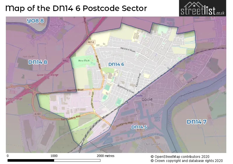
The DN14 6 Postcode shares a border with DN14 8 (Rawcliffe, Swinefleet, Rawcliffe Bridge) and DN14 5 (GOOLE, Hook).
The sector is within the post town of GOOLE.
DN14 6 is a postcode sector within the DN14 postcode district which is within the DN Doncaster postcode area.
The Royal Mail delivery office for the DN14 6 postal sector is the Goole Delivery Office.
The area of the DN14 6 postcode sector is 1.67 square miles which is 4.33 square kilometres or 1,069.34 square acres.
The DN14 6 postcode sector is crossed by the M62 motorway.

Map of the DN14 6 Postcode Sector
Explore the DN14 6 postcode sector by using our free interactive map.
| D | N | 1 | 4 | - | 6 | X | X |
| D | N | 1 | 4 | Space | 6 | Letter | Letter |
Official List of Streets
GOOLE (165 Streets)
Airmyn (1 Streets)
Unofficial Streets or Alternative Spellings
Weather Forecast for DN14 6
Press Button to Show Forecast for Goole
| Time Period | Icon | Description | Temperature | Rain Probability | Wind |
|---|---|---|---|---|---|
| 06:00 to 09:00 | Cloudy | 3.0°C (feels like 1.0°C) | 8.00% | NNW 4 mph | |
| 09:00 to 12:00 | Cloudy | 7.0°C (feels like 6.0°C) | 7.00% | NNE 4 mph | |
| 12:00 to 15:00 | Overcast | 9.0°C (feels like 7.0°C) | 13.00% | ENE 7 mph | |
| 15:00 to 18:00 | Cloudy | 9.0°C (feels like 7.0°C) | 9.00% | ENE 7 mph | |
| 18:00 to 21:00 | Cloudy | 8.0°C (feels like 6.0°C) | 8.00% | E 7 mph | |
| 21:00 to 00:00 | Partly cloudy (night) | 5.0°C (feels like 3.0°C) | 3.00% | E 4 mph |
Press Button to Show Forecast for Goole
| Time Period | Icon | Description | Temperature | Rain Probability | Wind |
|---|---|---|---|---|---|
| 00:00 to 03:00 | Partly cloudy (night) | 4.0°C (feels like 2.0°C) | 4.00% | ENE 4 mph | |
| 03:00 to 06:00 | Partly cloudy (night) | 3.0°C (feels like 1.0°C) | 5.00% | ENE 4 mph | |
| 06:00 to 09:00 | Cloudy | 5.0°C (feels like 2.0°C) | 11.00% | ENE 7 mph | |
| 09:00 to 12:00 | Cloudy | 8.0°C (feels like 6.0°C) | 11.00% | ENE 9 mph | |
| 12:00 to 15:00 | Overcast | 10.0°C (feels like 7.0°C) | 18.00% | E 11 mph | |
| 15:00 to 18:00 | Overcast | 10.0°C (feels like 8.0°C) | 19.00% | ENE 11 mph | |
| 18:00 to 21:00 | Cloudy | 9.0°C (feels like 6.0°C) | 18.00% | ENE 11 mph | |
| 21:00 to 00:00 | Cloudy | 7.0°C (feels like 5.0°C) | 13.00% | NE 9 mph |
Press Button to Show Forecast for Goole
| Time Period | Icon | Description | Temperature | Rain Probability | Wind |
|---|---|---|---|---|---|
| 00:00 to 03:00 | Overcast | 7.0°C (feels like 4.0°C) | 21.00% | NE 9 mph | |
| 03:00 to 06:00 | Light rain | 7.0°C (feels like 4.0°C) | 51.00% | NE 9 mph | |
| 06:00 to 09:00 | Cloudy | 8.0°C (feels like 5.0°C) | 28.00% | NE 9 mph | |
| 09:00 to 12:00 | Heavy rain | 10.0°C (feels like 7.0°C) | 78.00% | ENE 11 mph | |
| 12:00 to 15:00 | Heavy rain | 11.0°C (feels like 9.0°C) | 76.00% | ENE 11 mph | |
| 15:00 to 18:00 | Heavy rain shower (day) | 11.0°C (feels like 9.0°C) | 60.00% | NE 11 mph | |
| 18:00 to 21:00 | Light rain shower (day) | 11.0°C (feels like 9.0°C) | 37.00% | NW 9 mph | |
| 21:00 to 00:00 | Cloudy | 8.0°C (feels like 6.0°C) | 11.00% | WSW 9 mph |
Schools and Places of Education Within the DN14 6 Postcode Sector
Boothferry Primary School
Community school
Newport Street, Goole, , DN14 6TL
Head: Mr Mike Sibley
Ofsted Rating: Good
Inspection: 2019-02-13 (1899 days ago)
Website: Visit Boothferry Primary School Website
Phone: 01405762151
Number of Pupils: 390
Goole Academy
Academy converter
Centenary Road, Goole, East Yorkshire, DN14 6AN
Head: Mrs Kirsty Holt
Ofsted Rating: Good
Inspection: 2022-09-22 (582 days ago)
Website: Visit Goole Academy Website
Phone: 01405504000
Number of Pupils: 1113
Parkside Primary School
Community school
Western Road, Goole, East Yorkshire, DN14 6RQ
Head: Miss Samantha O'Brien
Ofsted Rating: Good
Inspection: 2020-03-04 (1514 days ago)
Website: Visit Parkside Primary School Website
Phone: 01405763634
Number of Pupils: 541
St Joseph's Catholic Primary School
Academy converter
Kennedy Drive, Goole, East Yorkshire, DN14 6HQ
Head: Mrs Helen Cooke
Ofsted Rating: Good
Inspection: 2023-11-07 (171 days ago)
Website: Visit St Joseph's Catholic Primary School Website
Phone: 01405762607
Number of Pupils: 107
House Prices in the DN14 6 Postcode Sector
| Type of Property | 2018 Average | 2018 Sales | 2017 Average | 2017 Sales | 2016 Average | 2016 Sales | 2015 Average | 2015 Sales |
|---|---|---|---|---|---|---|---|---|
| Detached | £211,218 | 40 | £216,531 | 45 | £194,837 | 46 | £190,749 | 38 |
| Semi-Detached | £146,746 | 75 | £136,665 | 80 | £131,233 | 75 | £126,768 | 65 |
| Terraced | £91,054 | 102 | £95,737 | 134 | £90,668 | 123 | £87,934 | 118 |
| Flats | £75,000 | 1 | £66,500 | 1 | £55,000 | 1 | £72,125 | 4 |
Important Postcodes DN14 6 in the Postcode Sector
DN14 6AL is the postcode for Bartholomew House, Boothferry Road
DN14 6AN is the postcode for Q BLOCK, Goole Academy, Boothferry Road, OLD MAIN BLOCK A, Goole Academy, Boothferry Road, NEW MAIN TEACHING BLOCK, Goole Academy, Boothferry Road, G BLOCK, Goole High School, Centenary Road, V BLOCK, Goole Academy, Boothferry Road, Goole Academy, Boothferry Road, M BLOCK, Goole High School, Centenary Road, SPORTS HALL TEACHING BLOCK C, Goole Academy, Boothferry Road, and SPORTS HALL, Goole Academy, Boothferry Road
DN14 6AW is the postcode for Goole Health Centre, Bartholomew Avenue
DN14 6DA is the postcode for Royal Mail, Goole Delivery Office, Larsen Road
DN14 6DP is the postcode for Adult Learning Centre, Pasture Road, and Pasture Road Day Centre, Pasture Road
DN14 6HQ is the postcode for St. Josephs RC Primary School, Kennedy Drive
DN14 6JD is the postcode for MONTAGUE MEDICAL CENTRE, FIFTH AVENUE
DN14 6PU is the postcode for Ilkeston Avenue Community Centre, Sandringham Drive
DN14 6RQ is the postcode for BLOCK A INFANT SCHOOL, Parkside Primary School, Western Road, Parkside Primary School, Western Road, and BLOCK D JUNIOR SCHOOL, Parkside Primary School, Western Road
DN14 6RU is the postcode for Goole Health Centre, Woodland Avenue, and PRIMARY CARE CENTRE, GOOLE HOSPITAL, Goole Health Centre, Woodland Avenue
DN14 6RX is the postcode for GOOLE AND DISTRICT HOSPITAL, WOODLAND AVENUE, Northern Lincolnshire and Goole NHS Foundation Trust, Goole and District Hospital, Woodland Avenue, Northern Lincolnshire and Goole NHS Foundation Trust, Goole and District Hospital, and AMBULANCE STATION - BLOCK 14A, Northern Lincolnshire and Goole Hospitals NHS Foundation Trust, Goole and District Hospital
DN14 6SR is the postcode for WORKSHOP BLOCK, Goole College, Boothferry Road, and Goole College, Boothferry Road
DN14 6SX is the postcode for East Riding of Yorkshire Council, Dunhill Road
DN14 6TA is the postcode for BMU, New Goole Depot, Seavy Road, and VMU, New Goole Depot, Seavy Road
DN14 6TL is the postcode for Boothferry Primary School, Newport Street
DN14 6XF is the postcode for Humberside Fire & Rescue Service, Fire Station, Larsen Road
| The DN14 6 Sector is within these Local Authorities |
|
|---|---|
| The DN14 6 Sector is within these Counties |
|
| The DN14 6 Sector is within these Water Company Areas |
|