The DY11 postcode district is a postal district located in the DY Dudley postcode area with a population of 32,221 residents according to the 2021 England and Wales Census.
The area of the DY11 postcode district is 13.75 square miles which is 35.61 square kilometres or 8,799.25 acres.
Currently, the DY11 district has about 810 postcode units spread across 3 geographic postcode sectors.
Given that each sector allows for 400 unique postcode combinations, the district has a capacity of 1,200 postcodes. With 810 postcodes already in use, this leaves 390 units available.
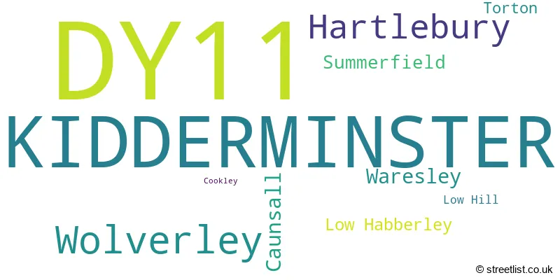
The largest settlement in the DY11 postal code is KIDDERMINSTER followed by Wolverley, and Hartlebury.
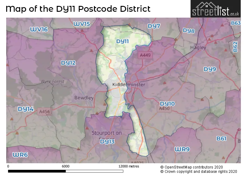
The DY11 Postcode shares a border with DY12 (BEWDLEY, Kinlet, Arley), DY7 (Kinver, Stourton, Enville), DY10 (KIDDERMINSTER, Cookley, Blakedown) and DY13 (STOURPORT-ON-SEVERN, Astley, Titton).
The primary settlement in the DY11 postcode district is Kidderminster, located in Worcestershire. Additionally, there are other significant settlements in this district, including Caunsall, Cookley, Low Habberley, Wolverley, Hartlebury, Low Hill, Summerfield, Torton, and Waresley. While Kidderminster is located in Worcestershire, Wolverley is located in Staffordshire. The most significant Postal Town in this district is Kidderminster.
For the district DY11, we have data on 4 postcode sectors. Here's a breakdown: The sector DY11 5, covers Kidderminster and Wolverley in Worcestershire. The sector DY11 6, covers Kidderminster in Worcestershire. The sector DY11 7, covers Kidderminster and Hartlebury in Worcestershire. The sector DY11 9 is non-geographic. It's often designated for PO Boxes, large organisations, or special services.

Map of the DY11 Postcode District
Explore the DY11 postcode district by using our free interactive map.
When it comes to local government, postal geography often disregards political borders. However, for a breakdown in the DY11 District: the district mostly encompasses the Wyre Forest District (741 postcodes), followed by the Wychavon District area (67 postcodes), and finally, the South Staffordshire District area (4 postcodes).
Recent House Sales in DY11
| Date | Price | Address |
|---|---|---|
| 17/10/2023 | £250,000 | Beechcote Avenue, Kidderminster, DY11 5TS |
| 22/09/2023 | £122,500 | Mill Street, Kidderminster, DY11 6GA |
| 22/09/2023 | £215,000 | Kinver Avenue, Kidderminster, DY11 7HA |
| 06/09/2023 | £227,000 | Clee Avenue, Kidderminster, DY11 7BS |
| 01/09/2023 | £255,000 | Crosbie Grove, Kidderminster, DY11 7DS |
| 01/09/2023 | £118,000 | Perrett Walk, Kidderminster, DY11 6SA |
| 30/08/2023 | £230,000 | Greatfield Road, Kidderminster, DY11 6PP |
| 30/08/2023 | £214,000 | Wilton Avenue, Kidderminster, DY11 5QF |
| 29/08/2023 | £390,000 | Waresley Road, Hartlebury, Kidderminster, DY11 7XT |
| 29/08/2023 | £193,000 | Beauchamp Heights, Kidderminster, DY11 7AD |
Weather Forecast for DY11
Press Button to Show Forecast for Kidderminster
| Time Period | Icon | Description | Temperature | Rain Probability | Wind |
|---|---|---|---|---|---|
| 09:00 to 12:00 | Cloudy | 7.0°C (feels like 5.0°C) | 6.00% | E 7 mph | |
| 12:00 to 15:00 | Overcast | 10.0°C (feels like 8.0°C) | 12.00% | ENE 7 mph | |
| 15:00 to 18:00 | Cloudy | 10.0°C (feels like 9.0°C) | 9.00% | ENE 7 mph | |
| 18:00 to 21:00 | Cloudy | 10.0°C (feels like 8.0°C) | 10.00% | ENE 7 mph | |
| 21:00 to 00:00 | Cloudy | 7.0°C (feels like 6.0°C) | 12.00% | ENE 7 mph |
Press Button to Show Forecast for Kidderminster
| Time Period | Icon | Description | Temperature | Rain Probability | Wind |
|---|---|---|---|---|---|
| 00:00 to 03:00 | Cloudy | 6.0°C (feels like 4.0°C) | 12.00% | ENE 7 mph | |
| 03:00 to 06:00 | Cloudy | 5.0°C (feels like 3.0°C) | 12.00% | ENE 7 mph | |
| 06:00 to 09:00 | Cloudy | 5.0°C (feels like 3.0°C) | 13.00% | NE 7 mph | |
| 09:00 to 12:00 | Cloudy | 8.0°C (feels like 5.0°C) | 17.00% | ENE 9 mph | |
| 12:00 to 15:00 | Light rain | 9.0°C (feels like 7.0°C) | 50.00% | ENE 9 mph | |
| 15:00 to 18:00 | Overcast | 10.0°C (feels like 8.0°C) | 23.00% | ENE 9 mph | |
| 18:00 to 21:00 | Cloudy | 10.0°C (feels like 8.0°C) | 18.00% | NE 9 mph | |
| 21:00 to 00:00 | Cloudy | 9.0°C (feels like 6.0°C) | 21.00% | NE 9 mph |
Press Button to Show Forecast for Kidderminster
| Time Period | Icon | Description | Temperature | Rain Probability | Wind |
|---|---|---|---|---|---|
| 00:00 to 03:00 | Light rain | 8.0°C (feels like 5.0°C) | 50.00% | NE 9 mph | |
| 03:00 to 06:00 | Light rain | 7.0°C (feels like 5.0°C) | 52.00% | NE 9 mph | |
| 06:00 to 09:00 | Light rain | 7.0°C (feels like 5.0°C) | 55.00% | NNE 9 mph | |
| 09:00 to 12:00 | Heavy rain | 9.0°C (feels like 7.0°C) | 76.00% | NNE 9 mph | |
| 12:00 to 15:00 | Light rain | 11.0°C (feels like 9.0°C) | 53.00% | ENE 11 mph | |
| 15:00 to 18:00 | Heavy rain shower (day) | 12.0°C (feels like 10.0°C) | 60.00% | NNW 9 mph | |
| 18:00 to 21:00 | Light rain shower (day) | 11.0°C (feels like 9.0°C) | 40.00% | NNE 9 mph | |
| 21:00 to 00:00 | Partly cloudy (night) | 9.0°C (feels like 7.0°C) | 10.00% | N 7 mph |
Where is the DY11 Postcode District?
The postcode district DY11 is located in Kidderminster. Kidderminster is situated near several towns. To the west is Bewdley, which is approximately 3.18 miles away. To the south is Stourport-on-Severn, which is approximately 4.35 miles away. Stourbridge is located in the northeast and is roughly 5.43 miles away. Halesowen is to the east and is around 9.18 miles away. Finally, Droitwich is situated in the southeast and is approximately 10.06 miles away. Kidderminster is also approximately 109.78 miles away from the center of London.
The district is within the post town of KIDDERMINSTER.
The sector has postcodes within the nation of England.
The DY11 Postcode District is covers the following regions.
- Worcestershire - Herefordshire, Worcestershire and Warwickshire - West Midlands (England)
- Staffordshire CC - Shropshire and Staffordshire - West Midlands (England)
| Postcode Sector | Delivery Office |
|---|---|
| DY11 5 | Cookley Scale Payment Delivery Office |
| DY11 5 | Kidderminster Delivery Office |
| DY11 6 | Kidderminster Delivery Office |
| DY11 7 | Kidderminster Delivery Office |
| D | Y | 1 | 1 | - | X | X | X |
| D | Y | 1 | 1 | Space | Numeric | Letter | Letter |
Current Monthly Rental Prices
| # Bedrooms | Min Price | Max Price | Avg Price |
|---|---|---|---|
| £7,500 | £7,500 | £7,500 | |
| 1 | £470 | £470 | £470 |
| 2 | £795 | £975 | £840 |
| 3 | £600 | £1,250 | £1,044 |
| 4 | £1,295 | £1,375 | £1,335 |
Current House Prices
| # Bedrooms | Min Price | Max Price | Avg Price |
|---|---|---|---|
| £185,000 | £300,000 | £242,500 | |
| 1 | £75,000 | £125,000 | £101,666 |
| 2 | £70,000 | £575,000 | £207,218 |
| 3 | £62,500 | £1,000,000 | £285,592 |
| 4 | £190,000 | £1,200,000 | £480,182 |
| 5 | £380,000 | £1,200,000 | £580,850 |
| 6 | £650,000 | £650,000 | £650,000 |
Estate Agents who Operate in the DY11 District
| Logo | Name | Brand Name | Address | Contact Number | Total Properties |
|---|---|---|---|---|---|
 | Kidderminster | Connells | 28-29 Worcester Street Kidderminster DY10 1ED | 01562 541721 | 28 |
 | Kidderminster | Shipways | 4 Carlton House, Marlborough Street, Kidderminster, DY10 1AY | 01562 543940 | 27 |
 | Kidderminster | Doolittle & Dalley | Estate House Proud Cross Ringway Kidderminster DY11 6AE | 01562 543884 | 13 |
 | Kidderminster | Dixons | 19 Oxford Street, Kidderminster, Worcestershire, DY10 1AU | 01562 547727 | 9 |
 | Kidderminster | Phipps & Pritchard | 32 Worcester Street Kidderminster DY10 1EW | 01562 543978 | 9 |
| Type of Property | 2018 Average | 2018 Sales | 2017 Average | 2017 Sales | 2016 Average | 2016 Sales | 2015 Average | 2015 Sales |
|---|---|---|---|---|---|---|---|---|
| Detached | £325,984 | 146 | £316,641 | 185 | £290,428 | 176 | £269,010 | 139 |
| Semi-Detached | £180,056 | 188 | £174,882 | 201 | £166,522 | 199 | £156,369 | 207 |
| Terraced | £140,019 | 124 | £140,090 | 168 | £145,869 | 116 | £131,435 | 124 |
| Flats | £107,626 | 37 | £115,279 | 35 | £97,287 | 34 | £99,800 | 46 |