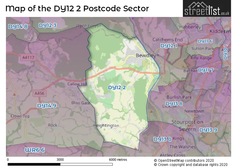
The DY12 2 postcode sector stands on the Worcestershire and Shropshire border.
Did you know? According to the 2021 Census, the DY12 2 postcode sector is home to a bustling 5,881 residents!
Given that each sector allows for 400 unique postcode combinations. Letters C, I, K, M, O and V are not allowed in the last two letters of a postcode. With 240 postcodes already in use, this leaves 160 units available.
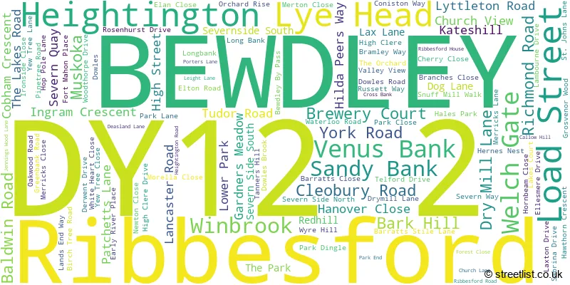
The largest settlement in the DY12 2 postal code is BEWDLEY followed by Ribbesford, and Heightington.
The DY12 2 Postcode shares a border with DY12 1 (BEWDLEY, Shatterford, Trimpley), DY13 0 (STOURPORT-ON-SEVERN, Astley, Dunley), DY12 3 (Kinlet, BEWDLEY, Arley), DY13 8 (STOURPORT-ON-SEVERN) and DY14 9 (Rock, Far Forest, Clows Top).
The sector is within the post town of BEWDLEY.
DY12 2 is a postcode sector within the DY12 postcode district which is within the DY Dudley postcode area.
The Royal Mail delivery office for the DY12 2 postal sector is the Kidderminster Delivery Office.
The area of the DY12 2 postcode sector is 8.31 square miles which is 21.51 square kilometres or 5,315.80 square acres.
Waterways within the DY12 2 postcode sector include the River Severn.

Map of the DY12 2 Postcode Sector
Explore the DY12 2 postcode sector by using our free interactive map.
| D | Y | 1 | 2 | - | 2 | X | X |
| D | Y | 1 | 2 | Space | 2 | Letter | Letter |
Official List of Streets
BEWDLEY (96 Streets)
Heightington (2 Streets)
Ribbesford (3 Streets)
Lye Head (1 Streets)
Unofficial Streets or Alternative Spellings
Weather Forecast for DY12 2
Press Button to Show Forecast for Bewdley
| Time Period | Icon | Description | Temperature | Rain Probability | Wind |
|---|---|---|---|---|---|
| 06:00 to 09:00 | Cloudy | 5.0°C (feels like 3.0°C) | 17.00% | ENE 4 mph | |
| 09:00 to 12:00 | Cloudy | 7.0°C (feels like 5.0°C) | 7.00% | E 7 mph | |
| 12:00 to 15:00 | Overcast | 9.0°C (feels like 8.0°C) | 12.00% | ENE 7 mph | |
| 15:00 to 18:00 | Cloudy | 10.0°C (feels like 9.0°C) | 11.00% | ENE 7 mph | |
| 18:00 to 21:00 | Cloudy | 9.0°C (feels like 8.0°C) | 10.00% | ENE 7 mph | |
| 21:00 to 00:00 | Cloudy | 7.0°C (feels like 5.0°C) | 12.00% | ENE 7 mph |
Press Button to Show Forecast for Bewdley
| Time Period | Icon | Description | Temperature | Rain Probability | Wind |
|---|---|---|---|---|---|
| 00:00 to 03:00 | Cloudy | 6.0°C (feels like 4.0°C) | 14.00% | ENE 7 mph | |
| 03:00 to 06:00 | Cloudy | 5.0°C (feels like 3.0°C) | 12.00% | NE 7 mph | |
| 06:00 to 09:00 | Cloudy | 5.0°C (feels like 3.0°C) | 13.00% | NE 7 mph | |
| 09:00 to 12:00 | Cloudy | 8.0°C (feels like 5.0°C) | 16.00% | ENE 9 mph | |
| 12:00 to 15:00 | Overcast | 9.0°C (feels like 7.0°C) | 25.00% | ENE 9 mph | |
| 15:00 to 18:00 | Overcast | 10.0°C (feels like 8.0°C) | 23.00% | ENE 9 mph | |
| 18:00 to 21:00 | Cloudy | 10.0°C (feels like 8.0°C) | 19.00% | NE 9 mph | |
| 21:00 to 00:00 | Cloudy | 8.0°C (feels like 6.0°C) | 23.00% | NE 9 mph |
Press Button to Show Forecast for Bewdley
| Time Period | Icon | Description | Temperature | Rain Probability | Wind |
|---|---|---|---|---|---|
| 00:00 to 03:00 | Overcast | 8.0°C (feels like 5.0°C) | 26.00% | NE 9 mph | |
| 03:00 to 06:00 | Light rain | 7.0°C (feels like 5.0°C) | 51.00% | NNE 9 mph | |
| 06:00 to 09:00 | Light rain | 7.0°C (feels like 5.0°C) | 54.00% | NNE 9 mph | |
| 09:00 to 12:00 | Heavy rain | 9.0°C (feels like 7.0°C) | 74.00% | NNE 9 mph | |
| 12:00 to 15:00 | Light rain | 11.0°C (feels like 9.0°C) | 53.00% | NW 11 mph | |
| 15:00 to 18:00 | Heavy rain shower (day) | 12.0°C (feels like 10.0°C) | 60.00% | NW 11 mph | |
| 18:00 to 21:00 | Light rain shower (day) | 11.0°C (feels like 9.0°C) | 38.00% | NNW 9 mph | |
| 21:00 to 00:00 | Clear night | 8.0°C (feels like 6.0°C) | 6.00% | W 7 mph |
Schools and Places of Education Within the DY12 2 Postcode Sector
St Anne's CofE VC Primary School
Voluntary controlled school
St Anne's CofE VC Primary School, Bewdley, Worcestershire, DY12 2UQ
Head: Mrs Joanne Harvey
Ofsted Rating: Requires improvement
Inspection: 2023-02-08 (443 days ago)
Website: Visit St Anne's CofE VC Primary School Website
Phone: 01299402013
Number of Pupils: 246
House Prices in the DY12 2 Postcode Sector
| Type of Property | 2018 Average | 2018 Sales | 2017 Average | 2017 Sales | 2016 Average | 2016 Sales | 2015 Average | 2015 Sales |
|---|---|---|---|---|---|---|---|---|
| Detached | £332,973 | 42 | £369,177 | 38 | £332,206 | 36 | £288,918 | 44 |
| Semi-Detached | £208,178 | 25 | £211,802 | 23 | £174,590 | 31 | £169,756 | 27 |
| Terraced | £211,494 | 26 | £197,180 | 25 | £178,318 | 14 | £174,057 | 21 |
| Flats | £135,182 | 14 | £127,393 | 14 | £120,438 | 8 | £130,719 | 16 |
Important Postcodes DY12 2 in the Postcode Sector
DY12 2AE is the postcode for Bewdley Town Hall & Museum, 12 Load Street, Bewdley Museum & Tourist Information, Load Street, and Wyre Forest District Council, Bewdley Museum, Load Street
DY12 2EF is the postcode for Bewdley Medical Centre, Dog Lane
DY12 2TY is the postcode for Frank Chapman Centre, Park End, Ribbesford, and Frank Chapman Centre, Park End
DY12 2UQ is the postcode for St. Anne's C. E. Primary School, Wyre Hill, St Anne's C. E. Primary School, Wyre Hill, St. Annes C of E First School, Wyre Hill, and St. Anne's C.E. Primary School, Wyre Hill
| The DY12 2 Sector is within these Local Authorities |
|
|---|---|
| The DY12 2 Sector is within these Counties |
|
| The DY12 2 Sector is within these Water Company Areas |
|