The DY7 5 postcode sector lies where the four counties of Staffordshire, West Midlands, Shropshire, and Worcestershire meet.
Did you know? According to the 2021 Census, the DY7 5 postcode sector is home to a bustling 1,833 residents!
Given that each sector allows for 400 unique postcode combinations. Letters C, I, K, M, O and V are not allowed in the last two letters of a postcode. With 156 postcodes already in use, this leaves 244 units available.
The largest settlement in the DY7 5 postal code is Enville followed by Bobbington, and STOURBRIDGE.
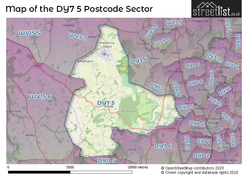
The DY7 5 Postcode shares a border with WV5 7 (Claverley, Seisdon, Trysull), DY3 4 (Swindon, DUDLEY, Himley), DY8 4 (STOURBRIDGE, Wollaston, Amblecote), DY8 5 (STOURBRIDGE, Wordsley), DY12 1 (BEWDLEY, Shatterford, Trimpley), WV15 6 (Alveley, BRIDGNORTH, Quatford), DY6 9 (KINGSWINFORD), DY6 0 (KINGSWINFORD, Wall Heath), DY7 6 (Kinver, Stourton, STOURBRIDGE) and DY11 5 (KIDDERMINSTER, Wolverley, Caunsall).
The sector is within the post town of STOURBRIDGE.
DY7 5 is a postcode sector within the DY7 postcode district which is within the DY Dudley postcode area.
The Royal Mail delivery office for the DY7 5 postal sector is the Stourbridge Delivery Office.
The area of the DY7 5 postcode sector is 19.55 square miles which is 50.65 square kilometres or 12,514.69 square acres.
Waterways within the DY7 5 postcode sector include the Staffordshire and Worcestershire Canal, Staffordshire & Worcestershire Canal, Smestow Brook, River Stour, Stourbridge Canal.

Map of the DY7 5 Postcode Sector
Explore the DY7 5 postcode sector by using our free interactive map.
| D | Y | 7 | - | 5 | X | X |
| D | Y | 7 | Space | 5 | Letter | Letter |
Official List of Streets
Enville (26 Streets)
STOURBRIDGE (15 Streets)
Bobbington (14 Streets)
Stourton (4 Streets)
Kinver (3 Streets)
Prestwood (2 Streets)
Unofficial Streets or Alternative Spellings
STOURBRIDGE
ASHDENE GARDENS BELLS LANE LAWNSWOOD ROAD STOURTON CRESCENT ASHWOOD LOWER LANE BANNUT TREE LANE BATH LANE CAMP HILL ROAD CLANBROOK ROAD ENVILLE COMMON ROAD GOTHERSLEY LANE GREAT CHECKHILL ROAD GREENFIELDS ROAD HERONS GATE ROAD HIGHGATE ROAD KINVER EDGE PERMISSIVE BRIDLWAY LITTLE CHECKHILL LANE ROCKY WALL RUTH SILK WAY SHEEPWALKS LANE SIX ASHES LANE THE AVENUE TOM LANE WATER LANE WHITE HOUSE LANE WIGLEY BANK ROAD WORLDS ENDSwindon
CHASEPOOL ROAD NEW ROAD WHITEHOUSE LANEWolverley
KINGSFORD LANE SHEEPWASH LANERomsley
BEACON LANEKinver
COMPTON ROAD HYDE LANEWeather Forecast for DY7 5
Press Button to Show Forecast for Wall Heath
| Time Period | Icon | Description | Temperature | Rain Probability | Wind |
|---|---|---|---|---|---|
| 12:00 to 15:00 | Cloudy | 9.0°C (feels like 7.0°C) | 6.00% | ENE 7 mph | |
| 15:00 to 18:00 | Overcast | 10.0°C (feels like 9.0°C) | 9.00% | ENE 7 mph | |
| 18:00 to 21:00 | Cloudy | 9.0°C (feels like 7.0°C) | 7.00% | ENE 9 mph | |
| 21:00 to 00:00 | Cloudy | 7.0°C (feels like 5.0°C) | 7.00% | ENE 9 mph |
Press Button to Show Forecast for Wall Heath
| Time Period | Icon | Description | Temperature | Rain Probability | Wind |
|---|---|---|---|---|---|
| 00:00 to 03:00 | Cloudy | 6.0°C (feels like 4.0°C) | 10.00% | ENE 9 mph | |
| 03:00 to 06:00 | Cloudy | 6.0°C (feels like 3.0°C) | 9.00% | ENE 7 mph | |
| 06:00 to 09:00 | Cloudy | 5.0°C (feels like 3.0°C) | 15.00% | ENE 7 mph | |
| 09:00 to 12:00 | Cloudy | 7.0°C (feels like 4.0°C) | 18.00% | ENE 9 mph | |
| 12:00 to 15:00 | Light rain | 8.0°C (feels like 5.0°C) | 50.00% | ENE 9 mph | |
| 15:00 to 18:00 | Overcast | 9.0°C (feels like 6.0°C) | 15.00% | NE 9 mph | |
| 18:00 to 21:00 | Overcast | 8.0°C (feels like 6.0°C) | 12.00% | NE 11 mph | |
| 21:00 to 00:00 | Cloudy | 7.0°C (feels like 4.0°C) | 13.00% | NE 9 mph |
Press Button to Show Forecast for Wall Heath
| Time Period | Icon | Description | Temperature | Rain Probability | Wind |
|---|---|---|---|---|---|
| 00:00 to 03:00 | Cloudy | 6.0°C (feels like 3.0°C) | 11.00% | NNE 9 mph | |
| 03:00 to 06:00 | Light rain | 6.0°C (feels like 2.0°C) | 46.00% | N 9 mph | |
| 06:00 to 09:00 | Light rain | 5.0°C (feels like 2.0°C) | 53.00% | NNW 11 mph | |
| 09:00 to 12:00 | Light rain | 7.0°C (feels like 4.0°C) | 51.00% | NNW 11 mph | |
| 12:00 to 15:00 | Overcast | 9.0°C (feels like 7.0°C) | 23.00% | NW 11 mph | |
| 15:00 to 18:00 | Cloudy | 11.0°C (feels like 8.0°C) | 13.00% | WNW 9 mph | |
| 18:00 to 21:00 | Partly cloudy (day) | 10.0°C (feels like 8.0°C) | 6.00% | W 7 mph | |
| 21:00 to 00:00 | Clear night | 7.0°C (feels like 5.0°C) | 2.00% | SW 4 mph |
Press Button to Show Forecast for Wall Heath
| Time Period | Icon | Description | Temperature | Rain Probability | Wind |
|---|---|---|---|---|---|
| 00:00 to 03:00 | Clear night | 5.0°C (feels like 3.0°C) | 1.00% | SSW 7 mph | |
| 03:00 to 06:00 | Clear night | 5.0°C (feels like 2.0°C) | 2.00% | S 7 mph | |
| 06:00 to 09:00 | Sunny day | 5.0°C (feels like 2.0°C) | 2.00% | S 7 mph | |
| 09:00 to 12:00 | Partly cloudy (day) | 10.0°C (feels like 8.0°C) | 2.00% | S 11 mph | |
| 12:00 to 15:00 | Overcast | 13.0°C (feels like 10.0°C) | 9.00% | S 13 mph | |
| 15:00 to 18:00 | Partly cloudy (day) | 13.0°C (feels like 11.0°C) | 6.00% | S 13 mph | |
| 18:00 to 21:00 | Partly cloudy (day) | 13.0°C (feels like 10.0°C) | 5.00% | S 11 mph | |
| 21:00 to 00:00 | Clear night | 10.0°C (feels like 8.0°C) | 2.00% | SSE 9 mph |
Press Button to Show Forecast for Wall Heath
| Time Period | Icon | Description | Temperature | Rain Probability | Wind |
|---|---|---|---|---|---|
| 00:00 to 03:00 | Clear night | 9.0°C (feels like 6.0°C) | 3.00% | SSE 9 mph | |
| 03:00 to 06:00 | Clear night | 8.0°C (feels like 5.0°C) | 3.00% | SE 9 mph | |
| 06:00 to 09:00 | Sunny day | 8.0°C (feels like 6.0°C) | 4.00% | SE 9 mph | |
| 09:00 to 12:00 | Sunny day | 12.0°C (feels like 10.0°C) | 5.00% | SE 11 mph | |
| 12:00 to 15:00 | Cloudy | 15.0°C (feels like 12.0°C) | 14.00% | SE 13 mph | |
| 15:00 to 18:00 | Partly cloudy (day) | 16.0°C (feels like 13.0°C) | 11.00% | SE 11 mph | |
| 18:00 to 21:00 | Partly cloudy (day) | 15.0°C (feels like 13.0°C) | 7.00% | SE 9 mph | |
| 21:00 to 00:00 | Cloudy | 12.0°C (feels like 11.0°C) | 9.00% | ESE 7 mph |
Schools and Places of Education Within the DY7 5 Postcode Sector
Corbett VA CofE Primary School
Voluntary aided school
Six Ashes Road, Stourbridge, West Midlands, DY7 5DU
Head: Mrs Emma Jones
Ofsted Rating: Good
Inspection: 2018-10-18 (2017 days ago)
Website: Visit Corbett VA CofE Primary School Website
Phone: 01384221260
Number of Pupils: 85
House Prices in the DY7 5 Postcode Sector
| Type of Property | 2018 Average | 2018 Sales | 2017 Average | 2017 Sales | 2016 Average | 2016 Sales | 2015 Average | 2015 Sales |
|---|---|---|---|---|---|---|---|---|
| Detached | £390,723 | 11 | £418,586 | 11 | £533,286 | 7 | £402,995 | 10 |
| Semi-Detached | £243,600 | 5 | £229,000 | 4 | £0 | 0 | £480,000 | 1 |
| Terraced | £245,000 | 1 | £294,975 | 2 | £0 | 0 | £257,000 | 4 |
| Flats | £125,000 | 1 | £119,950 | 1 | £165,375 | 4 | £0 | 0 |
| The DY7 5 Sector is within these Local Authorities |
|
|---|---|
| The DY7 5 Sector is within these Counties |
|
| The DY7 5 Sector is within these Water Company Areas |
|