The EH36 postcode district is a postal district located in the EH Edinburgh postcode area with a population of 383 residents according to the 2011 Scotland Census.
The area of the EH36 postcode district is 12.60 square miles which is 32.64 square kilometres or 8,064.32 acres.
Currently, the EH36 district has about 11 postcode units spread across 1 geographic postcode sectors.
Given that each sector allows for 400 unique postcode combinations, the district has a capacity of 400 postcodes. With 11 postcodes already in use, this leaves 389 units available.
The EH36 postal code covers the settlement of HUMBIE.
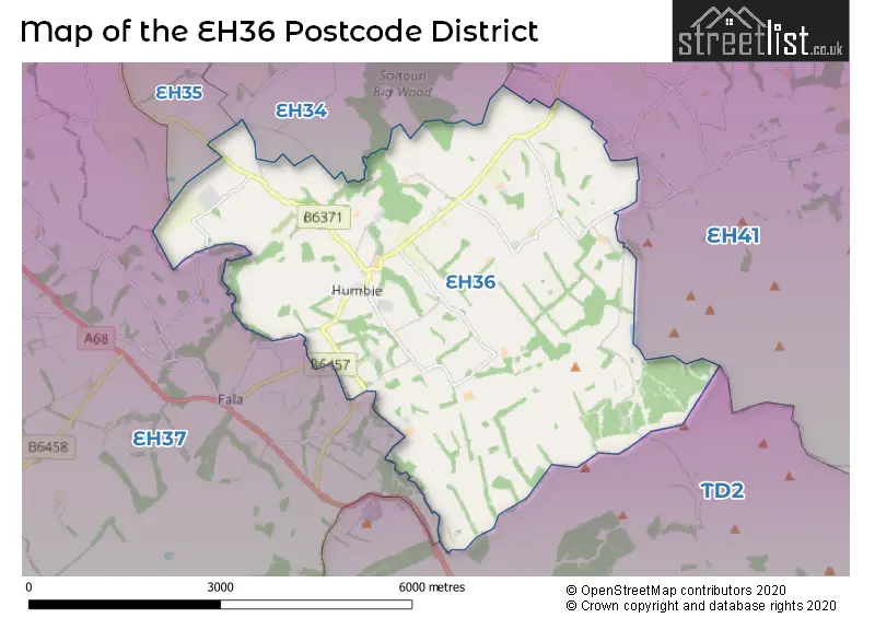
The EH36 Postcode shares a border with EH34 (Pencaitland), TD2 (LAUDER, Oxton), EH37 (PATHHEAD, Edgehead, Tynehead) and EH41 (HADDINGTON, Gifford).
The primary settlement in the EH36 postcode district is Humbie, located in East Lothian. This postcode district also encompasses other significant settlements. However, due to the lack of available data, we cannot provide further details on these settlements. The most significant post town in this district is also Humbie. East Lothian is the county in which Humbie and the EH36 postcode district are situated, and it is located in Scotland.
For the district EH36, we have data on 1 postcode sectors. Here's a breakdown: The sector EH36 5, covers Humbie in East Lothian.
EH36 Postcode Sectors

Map of the EH36 Postcode District
Explore the EH36 postcode district by using our free interactive map.
When it comes to local government, postal geography often disregards political borders. However, for a breakdown in the EH36 District: the district mostly encompasses the East Lothian area with a total of 11 postcodes.
Where is the EH36 Postcode District?
The EH36 postcode district is located in the town of Humbie. It is situated near several towns, including Pathhead to the west, Haddington to the northeast, Tranent to the northwest, Heriot to the southwest, Lauder to the southeast, and Longniddry to the north. Additionally, this district is approximately 320.45 miles away from the center of London.
The district is within the post town of HUMBIE.
The sector has postcodes within the nation of Scotland.
The EH36 Postcode District is in the East Lothian and Midlothian region of Eastern Scotland within the Scotland.
Weather Forecast for EH36
Press Button to Show Forecast for St Mary's Pleasance Haddington
| Time Period | Icon | Description | Temperature | Rain Probability | Wind |
|---|---|---|---|---|---|
| 06:00 to 09:00 | Cloudy | 14.0°C (feels like 13.0°C) | 5.00% | ESE 7 mph | |
| 09:00 to 12:00 | Cloudy | 16.0°C (feels like 15.0°C) | 10.00% | E 9 mph | |
| 12:00 to 15:00 | Cloudy | 15.0°C (feels like 13.0°C) | 12.00% | E 11 mph | |
| 15:00 to 18:00 | Cloudy | 14.0°C (feels like 12.0°C) | 14.00% | ENE 11 mph | |
| 18:00 to 21:00 | Cloudy | 14.0°C (feels like 12.0°C) | 7.00% | E 9 mph | |
| 21:00 to 00:00 | Cloudy | 12.0°C (feels like 11.0°C) | 7.00% | E 7 mph |
Press Button to Show Forecast for St Mary's Pleasance Haddington
| Time Period | Icon | Description | Temperature | Rain Probability | Wind |
|---|---|---|---|---|---|
| 00:00 to 03:00 | Cloudy | 13.0°C (feels like 12.0°C) | 7.00% | ENE 7 mph | |
| 03:00 to 06:00 | Cloudy | 12.0°C (feels like 11.0°C) | 5.00% | ENE 4 mph | |
| 06:00 to 09:00 | Cloudy | 12.0°C (feels like 12.0°C) | 4.00% | ESE 4 mph | |
| 09:00 to 12:00 | Cloudy | 15.0°C (feels like 14.0°C) | 5.00% | ENE 7 mph | |
| 12:00 to 15:00 | Partly cloudy (day) | 16.0°C (feels like 15.0°C) | 1.00% | ENE 9 mph | |
| 15:00 to 18:00 | Partly cloudy (day) | 15.0°C (feels like 13.0°C) | 1.00% | ENE 11 mph | |
| 18:00 to 21:00 | Partly cloudy (day) | 13.0°C (feels like 11.0°C) | 1.00% | ENE 11 mph | |
| 21:00 to 00:00 | Clear night | 11.0°C (feels like 9.0°C) | 3.00% | ENE 9 mph |
Press Button to Show Forecast for St Mary's Pleasance Haddington
| Time Period | Icon | Description | Temperature | Rain Probability | Wind |
|---|---|---|---|---|---|
| 00:00 to 03:00 | Partly cloudy (night) | 10.0°C (feels like 8.0°C) | 3.00% | NE 7 mph | |
| 03:00 to 06:00 | Clear night | 10.0°C (feels like 8.0°C) | 3.00% | NE 7 mph | |
| 06:00 to 09:00 | Cloudy | 11.0°C (feels like 10.0°C) | 5.00% | NE 7 mph | |
| 09:00 to 12:00 | Cloudy | 13.0°C (feels like 11.0°C) | 6.00% | NE 9 mph | |
| 12:00 to 15:00 | Cloudy | 15.0°C (feels like 13.0°C) | 4.00% | ENE 9 mph | |
| 15:00 to 18:00 | Partly cloudy (day) | 14.0°C (feels like 13.0°C) | 1.00% | ENE 9 mph | |
| 18:00 to 21:00 | Sunny day | 13.0°C (feels like 11.0°C) | 1.00% | ENE 9 mph | |
| 21:00 to 00:00 | Clear night | 10.0°C (feels like 9.0°C) | 1.00% | NE 7 mph |
Press Button to Show Forecast for St Mary's Pleasance Haddington
| Time Period | Icon | Description | Temperature | Rain Probability | Wind |
|---|---|---|---|---|---|
| 00:00 to 03:00 | Clear night | 10.0°C (feels like 8.0°C) | 1.00% | NE 7 mph | |
| 03:00 to 06:00 | Clear night | 10.0°C (feels like 8.0°C) | 1.00% | NNE 7 mph | |
| 06:00 to 09:00 | Sunny day | 11.0°C (feels like 10.0°C) | 3.00% | NNE 7 mph | |
| 09:00 to 12:00 | Partly cloudy (day) | 13.0°C (feels like 12.0°C) | 4.00% | NE 9 mph | |
| 12:00 to 15:00 | Sunny day | 15.0°C (feels like 13.0°C) | 5.00% | NE 9 mph | |
| 15:00 to 18:00 | Sunny day | 15.0°C (feels like 13.0°C) | 4.00% | ENE 9 mph | |
| 18:00 to 21:00 | Partly cloudy (day) | 13.0°C (feels like 12.0°C) | 4.00% | NE 9 mph | |
| 21:00 to 00:00 | Partly cloudy (night) | 11.0°C (feels like 9.0°C) | 5.00% | NE 7 mph |
Press Button to Show Forecast for St Mary's Pleasance Haddington
| Time Period | Icon | Description | Temperature | Rain Probability | Wind |
|---|---|---|---|---|---|
| 00:00 to 03:00 | Partly cloudy (night) | 10.0°C (feels like 9.0°C) | 5.00% | NNE 7 mph | |
| 03:00 to 06:00 | Partly cloudy (night) | 9.0°C (feels like 8.0°C) | 6.00% | NNE 4 mph | |
| 06:00 to 09:00 | Cloudy | 11.0°C (feels like 9.0°C) | 8.00% | NNE 7 mph | |
| 09:00 to 12:00 | Partly cloudy (day) | 13.0°C (feels like 12.0°C) | 5.00% | NE 7 mph | |
| 12:00 to 15:00 | Cloudy | 14.0°C (feels like 13.0°C) | 6.00% | ENE 7 mph | |
| 15:00 to 18:00 | Sunny day | 15.0°C (feels like 13.0°C) | 2.00% | ENE 7 mph | |
| 18:00 to 21:00 | Sunny day | 13.0°C (feels like 12.0°C) | 1.00% | E 7 mph | |
| 21:00 to 00:00 | Clear night | 10.0°C (feels like 9.0°C) | 1.00% | E 7 mph |
Postcode Sectors within the EH36 District
| Postcode Sector | Delivery Office |
|---|---|
| EH36 5 | Dalkeith Delivery Office |
| E | H | 3 | 6 | - | X | X | X |
| E | H | 3 | 6 | Space | Numeric | Letter | Letter |
Current Monthly Rental Prices
| # Bedrooms | Min Price | Max Price | Avg Price |
|---|
Current House Prices
| # Bedrooms | Min Price | Max Price | Avg Price |
|---|---|---|---|
| 3 | £540,000 | £540,000 | £540,000 |
| 4 | £565,000 | £565,000 | £565,000 |
Estate Agents who Operate in the EH36 District
| Logo | Name | Brand Name | Address | Contact Number | Total Properties |
|---|---|---|---|---|---|
 | Edinburgh | Strutt & Parker | 76 George Street Edinburgh EH2 3BU | 0131 381 0648 | 1 |
 | Hawick | Cullen Kilshaw | 55 High Street, Hawick, TD9 9BP | 01451 604180 | 1 |