The EN5 1 postcode sector is within the county of Greater London.
Did you know? According to the 2021 Census, the EN5 1 postcode sector is home to a bustling 7,672 residents!
Given that each sector allows for 400 unique postcode combinations. Letters C, I, K, M, O and V are not allowed in the last two letters of a postcode. With 199 postcodes already in use, this leaves 201 units available.
The largest settlement in the EN5 1 postal code is NEW BARNET followed by BARNET , and UNDERHILL .
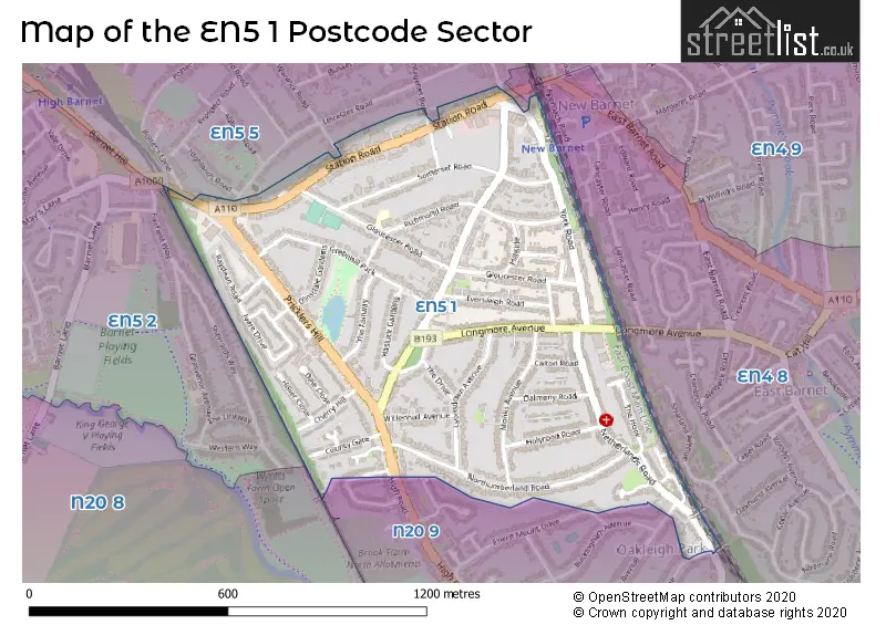
The EN5 1 Postcode shares a border with EN5 2 (BARNET , UNDERHILL , CHIPPING BARNET ), N20 8 (WHETSTONE , TOTTERIDGE ), N20 9 (WHETSTONE ), EN4 8 (EAST BARNET , NEW BARNET , STATION ROAD TO BROOKHILL ROAD ) and EN5 5 (NEW BARNET , BARNET , POTTERS ROAD TO HADLEY COMMON ).
The sector is within the post town of BARNET.
EN5 1 is a postcode sector within the EN5 postcode district which is within the EN Enfield postcode area.
The Royal Mail delivery office for the EN5 1 postal sector is the Barnet Delivery Office.
The area of the EN5 1 postcode sector is 0.48 square miles which is 1.26 square kilometres or 310.20 square acres.

Map of the EN5 1 Postcode Sector
Explore the EN5 1 postcode sector by using our free interactive map.
| E | N | 5 | - | 1 | X | X |
| E | N | 5 | Space | 1 | Letter | Letter |
Official List of Streets
New Barnet (38 Streets)
BARNET (16 Streets)
Unofficial Streets or Alternative Spellings
Barnet
CHANDOS AVENUE HIGH ROAD OAKLEIGH PARK NORTH TEMPLE AVENUE WALFIELD AVENUEBARNET
BARNET HILL DUNCAN CLOSE EAST BARNET ROAD PLANTAGENET ROAD POTTERS LANE WARWICK ROADNew Barnet
LEICESTER ROAD LYTTON ROAD CROFTON WAY GREENHILL PARADE HILL SIDE HOMESTEAD COURT MEADOW WORKS PRESTON COURT PRICKLERS HILL TEMPLE PARADE THE COPPICE WESTERN PARADEEast Barnet
LONGMORE AVENUEWeather Forecast for EN5 1
Press Button to Show Forecast for Barnet
| Time Period | Icon | Description | Temperature | Rain Probability | Wind |
|---|---|---|---|---|---|
| 03:00 to 06:00 | Cloudy | 3.0°C (feels like 1.0°C) | 4.00% | NE 7 mph | |
| 06:00 to 09:00 | Partly cloudy (day) | 3.0°C (feels like 0.0°C) | 1.00% | NE 7 mph | |
| 09:00 to 12:00 | Partly cloudy (day) | 7.0°C (feels like 4.0°C) | 2.00% | ENE 7 mph | |
| 12:00 to 15:00 | Cloudy | 10.0°C (feels like 8.0°C) | 9.00% | ENE 7 mph | |
| 15:00 to 18:00 | Overcast | 10.0°C (feels like 9.0°C) | 14.00% | ENE 4 mph | |
| 18:00 to 21:00 | Cloudy | 9.0°C (feels like 7.0°C) | 11.00% | ENE 7 mph | |
| 21:00 to 00:00 | Cloudy | 6.0°C (feels like 4.0°C) | 11.00% | E 7 mph |
Press Button to Show Forecast for Barnet
| Time Period | Icon | Description | Temperature | Rain Probability | Wind |
|---|---|---|---|---|---|
| 00:00 to 03:00 | Cloudy | 4.0°C (feels like 2.0°C) | 12.00% | ENE 7 mph | |
| 03:00 to 06:00 | Cloudy | 4.0°C (feels like 1.0°C) | 18.00% | NE 7 mph | |
| 06:00 to 09:00 | Cloudy | 4.0°C (feels like 1.0°C) | 20.00% | NE 9 mph | |
| 09:00 to 12:00 | Overcast | 8.0°C (feels like 6.0°C) | 19.00% | ENE 9 mph | |
| 12:00 to 15:00 | Overcast | 11.0°C (feels like 8.0°C) | 20.00% | E 9 mph | |
| 15:00 to 18:00 | Cloudy | 11.0°C (feels like 9.0°C) | 21.00% | E 11 mph | |
| 18:00 to 21:00 | Cloudy | 10.0°C (feels like 8.0°C) | 23.00% | ENE 11 mph | |
| 21:00 to 00:00 | Light rain | 8.0°C (feels like 5.0°C) | 51.00% | NE 13 mph |
Press Button to Show Forecast for Barnet
| Time Period | Icon | Description | Temperature | Rain Probability | Wind |
|---|---|---|---|---|---|
| 00:00 to 03:00 | Heavy rain | 8.0°C (feels like 5.0°C) | 73.00% | NE 11 mph | |
| 03:00 to 06:00 | Light rain | 8.0°C (feels like 6.0°C) | 55.00% | E 9 mph | |
| 06:00 to 09:00 | Cloudy | 9.0°C (feels like 6.0°C) | 41.00% | SE 9 mph | |
| 09:00 to 12:00 | Light rain shower (day) | 10.0°C (feels like 8.0°C) | 46.00% | SE 9 mph | |
| 12:00 to 15:00 | Heavy rain shower (day) | 11.0°C (feels like 9.0°C) | 62.00% | S 9 mph | |
| 15:00 to 18:00 | Light rain shower (day) | 13.0°C (feels like 10.0°C) | 42.00% | SW 11 mph | |
| 18:00 to 21:00 | Cloudy | 11.0°C (feels like 9.0°C) | 17.00% | SW 11 mph | |
| 21:00 to 00:00 | Overcast | 9.0°C (feels like 7.0°C) | 11.00% | WSW 9 mph |
House Prices in the EN5 1 Postcode Sector
| Type of Property | 2018 Average | 2018 Sales | 2017 Average | 2017 Sales | 2016 Average | 2016 Sales | 2015 Average | 2015 Sales |
|---|---|---|---|---|---|---|---|---|
| Detached | £944,833 | 12 | £1,009,000 | 5 | £993,667 | 9 | £1,021,600 | 10 |
| Semi-Detached | £674,502 | 33 | £750,696 | 27 | £707,297 | 35 | £659,916 | 34 |
| Terraced | £528,550 | 10 | £533,083 | 6 | £584,525 | 10 | £484,155 | 19 |
| Flats | £363,833 | 55 | £369,241 | 45 | £353,272 | 64 | £317,629 | 56 |
Important Postcodes EN5 1 in the Postcode Sector
EN5 1AA is the postcode for Royal Mail, Barnet Delivery Office, 55 Longmore Avenue
EN5 1AH is the postcode for Jobcentre Plus, Raydean House, 15 Great North Road, Western Parade, New Barnet, and Jobcentre Plus, Raydean House, 15 Great North Road, Western Parade
EN5 1SA is the postcode for Lyonsdown School, 3 Richmond Road, New Barnet, and Lyonsdown School, 3 Richmond Road
EN5 1TE is the postcode for Barnet Fire Station, 144 Station Road, and BARNET FIRE STATION, 144 STATION ROAD, NEW BARNET
| The EN5 1 Sector is within these Local Authorities |
|
|---|---|
| The EN5 1 Sector is within these Counties |
|
| The EN5 1 Sector is within these Water Company Areas |
|