The EN5 postcode district is a postal district located in the EN Enfield postcode area with a population of 39,898 residents according to the 2021 England and Wales Census.
The area of the EN5 postcode district is 8.86 square miles which is 22.96 square kilometres or 5,673.26 acres.
Currently, the EN5 district has about 1063 postcode units spread across 5 geographic postcode sectors.
Given that each sector allows for 400 unique postcode combinations, the district has a capacity of 2,000 postcodes. With 1063 postcodes already in use, this leaves 937 units available.
The largest settlements in the EN5 postal code are BARNET and NEW BARNET.
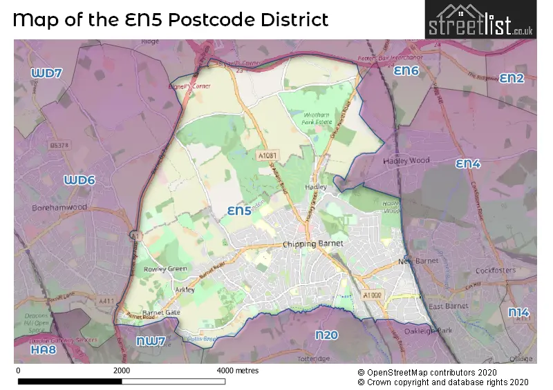
The EN5 Postcode shares a border with EN6 (POTTERS BAR, CUFFLEY), WD6 (BOREHAMWOOD, ELSTREE), EN4 (EAST BARNET, NEW BARNET, ENFIELD), N20 (WHETSTONE) and NW7 (MILL HILL).
In the EN5 postcode district, the primary settlement is Barnet, located in the county of Greater London. Other significant settlements include New Barnet, Arkley, Bentley Heath, and High Barnet. The most significant post town in this district is Barnet.
For the district EN5, we have data on 6 postcode sectors. Here's a breakdown: The sector EN5 1, covers New Barnet and Barnet in Greater London. The sector EN5 2, covers Barnet in Greater London. The sector EN5 3, covers Barnet in Greater London. The sector EN5 4, covers Barnet in Greater London. The sector EN5 4, covers Barnet in Hertfordshire. The sector EN5 5, covers Barnet in Greater London. The sector EN5 9 is non-geographic. It's often designated for PO Boxes, large organisations, or special services.


Map of the EN5 Postcode District
Explore the EN5 postcode district by using our free interactive map.
When it comes to local government, postal geography often disregards political borders. However, for a breakdown in the EN5 District: the district mostly encompasses the Barnet London Boro (1039 postcodes), and finally, the Hertsmere District (B) area (27 postcodes).
Recent House Sales in EN5
| Date | Price | Address |
|---|---|---|
| 16/10/2023 | £820,000 | Wood Street, Barnet, EN5 4BW |
| 13/10/2023 | £305,000 | Hadley Road, Barnet, EN5 5QH |
| 05/10/2023 | £699,500 | Hera Avenue, Barnet, EN5 2FQ |
| 22/09/2023 | £260,000 | Bells Hill, Barnet, EN5 2SR |
| 22/09/2023 | £230,000 | Christ Church Lane, Barnet, EN5 4PL |
| 18/09/2023 | £340,000 | Christ Church Lane, Barnet, EN5 4PL |
| 15/09/2023 | £445,000 | Mays Lane, Barnet, EN5 2QQ |
| 08/09/2023 | £365,000 | Wentworth Road, Barnet, EN5 4PA |
| 08/09/2023 | £238,000 | Leicester Road, Barnet, EN5 5DY |
| 08/09/2023 | £690,000 | Hadley Road, Barnet, EN5 5QH |
Weather Forecast for EN5
Press Button to Show Forecast for Barnet
| Time Period | Icon | Description | Temperature | Rain Probability | Wind |
|---|---|---|---|---|---|
| 06:00 to 09:00 | Heavy rain | 5.0°C (feels like 2.0°C) | 80.00% | NE 9 mph | |
| 09:00 to 12:00 | Light rain | 6.0°C (feels like 3.0°C) | 45.00% | NE 11 mph | |
| 12:00 to 15:00 | Overcast | 9.0°C (feels like 7.0°C) | 14.00% | NE 9 mph | |
| 15:00 to 18:00 | Cloudy | 11.0°C (feels like 9.0°C) | 16.00% | NE 9 mph | |
| 18:00 to 21:00 | Light rain | 10.0°C (feels like 8.0°C) | 52.00% | NE 11 mph | |
| 21:00 to 00:00 | Light rain | 8.0°C (feels like 6.0°C) | 67.00% | NNE 11 mph |
Press Button to Show Forecast for Barnet
| Time Period | Icon | Description | Temperature | Rain Probability | Wind |
|---|---|---|---|---|---|
| 00:00 to 03:00 | Heavy rain | 8.0°C (feels like 4.0°C) | 89.00% | NNE 13 mph | |
| 03:00 to 06:00 | Heavy rain | 7.0°C (feels like 4.0°C) | 89.00% | NNE 11 mph | |
| 06:00 to 09:00 | Heavy rain | 7.0°C (feels like 4.0°C) | 87.00% | N 11 mph | |
| 09:00 to 12:00 | Heavy rain | 8.0°C (feels like 5.0°C) | 78.00% | NNW 9 mph | |
| 12:00 to 15:00 | Light rain | 9.0°C (feels like 6.0°C) | 55.00% | WNW 11 mph | |
| 15:00 to 18:00 | Overcast | 10.0°C (feels like 7.0°C) | 20.00% | W 11 mph | |
| 18:00 to 21:00 | Cloudy | 10.0°C (feels like 8.0°C) | 10.00% | W 9 mph | |
| 21:00 to 00:00 | Cloudy | 8.0°C (feels like 6.0°C) | 8.00% | SW 7 mph |
Press Button to Show Forecast for Barnet
| Time Period | Icon | Description | Temperature | Rain Probability | Wind |
|---|---|---|---|---|---|
| 00:00 to 03:00 | Clear night | 7.0°C (feels like 5.0°C) | 3.00% | SW 7 mph | |
| 03:00 to 06:00 | Clear night | 5.0°C (feels like 3.0°C) | 1.00% | SSW 7 mph | |
| 06:00 to 09:00 | Sunny day | 6.0°C (feels like 3.0°C) | 1.00% | S 7 mph | |
| 09:00 to 12:00 | Sunny day | 10.0°C (feels like 8.0°C) | 3.00% | S 9 mph | |
| 12:00 to 15:00 | Cloudy | 13.0°C (feels like 11.0°C) | 5.00% | S 11 mph | |
| 15:00 to 18:00 | Partly cloudy (day) | 14.0°C (feels like 11.0°C) | 2.00% | S 13 mph | |
| 18:00 to 21:00 | Sunny day | 13.0°C (feels like 11.0°C) | 4.00% | S 11 mph | |
| 21:00 to 00:00 | Clear night | 10.0°C (feels like 8.0°C) | 1.00% | SSE 9 mph |
Press Button to Show Forecast for Barnet
| Time Period | Icon | Description | Temperature | Rain Probability | Wind |
|---|---|---|---|---|---|
| 00:00 to 03:00 | Clear night | 9.0°C (feels like 6.0°C) | 1.00% | SE 9 mph | |
| 03:00 to 06:00 | Clear night | 8.0°C (feels like 5.0°C) | 2.00% | ESE 9 mph | |
| 06:00 to 09:00 | Partly cloudy (day) | 8.0°C (feels like 6.0°C) | 5.00% | ESE 9 mph | |
| 09:00 to 12:00 | Partly cloudy (day) | 12.0°C (feels like 10.0°C) | 6.00% | ESE 9 mph | |
| 12:00 to 15:00 | Cloudy | 15.0°C (feels like 13.0°C) | 10.00% | SE 11 mph | |
| 15:00 to 18:00 | Cloudy | 16.0°C (feels like 14.0°C) | 13.00% | SE 9 mph | |
| 18:00 to 21:00 | Cloudy | 15.0°C (feels like 13.0°C) | 12.00% | SE 9 mph | |
| 21:00 to 00:00 | Cloudy | 12.0°C (feels like 11.0°C) | 10.00% | ESE 9 mph |
Where is the EN5 Postcode District?
The EN5 postcode district belongs to the town of Barnet, which is located in the Barnet district. It is situated within proximity to several nearby towns. To the southwest, there is Arkley Barnet Section, which is approximately 0.57 miles away. To the northeast, there is Dury Road to Great North Road, approximately 0.73 miles away. Chipping Barnet is located to the south, around 0.76 miles away. Monken Hadley is situated to the east, roughly 0.98 miles away. Finally, to the southeast, there is Remainder from Number Forty One Pri, which is approximately 1.12 miles away. Additionally, Barnet is located about 11.15 miles away from the center of London.
The district is within the post town of BARNET.
The sector has postcodes within the nation of England.
The EN5 Postcode District is covers the following regions.
- Barnet - Outer London - West and North West - London
- Hertfordshire - Bedfordshire and Hertfordshire - East of England
| Postcode Sector | Delivery Office |
|---|---|
| EN5 1 | Barnet Delivery Office |
| EN5 2 | Barnet Delivery Office |
| EN5 3 | Barnet Delivery Office |
| EN5 4 | Barnet Delivery Office |
| EN5 5 | Barnet Delivery Office |
| E | N | 5 | - | X | X | X |
| E | N | 5 | Space | Numeric | Letter | Letter |
Tourist Attractions within the Postcode Area
We found 1 visitor attractions within the EN5 postcode area
| Barnet Museum |
|---|
| Museums & Art Galleries |
| Museum and / or Art Gallery |
| View Barnet Museum on Google Maps |
Current Monthly Rental Prices
| # Bedrooms | Min Price | Max Price | Avg Price |
|---|---|---|---|
| £600 | £1,500 | £1,174 | |
| 1 | £1,200 | £2,275 | £1,505 |
| 2 | £700 | £4,000 | £1,896 |
| 3 | £1,950 | £6,604 | £2,827 |
| 4 | £2,200 | £3,100 | £2,805 |
| 6 | £8,000 | £8,000 | £8,000 |
Current House Prices
| # Bedrooms | Min Price | Max Price | Avg Price |
|---|---|---|---|
| £50,000 | £1,500,000 | £360,454 | |
| 1 | £129,950 | £435,000 | £273,523 |
| 2 | £135,000 | £1,100,000 | £435,291 |
| 3 | £430,000 | £1,550,000 | £715,403 |
| 4 | £500,000 | £1,625,000 | £1,006,500 |
| 5 | £799,995 | £5,500,000 | £1,902,269 |
| 6 | £860,000 | £3,750,000 | £2,167,692 |
| 7 | £2,495,000 | £2,495,000 | £2,495,000 |
| 8 | £2,000,000 | £12,000,000 | £7,249,750 |
| 9 | £1,170,000 | £1,170,000 | £1,170,000 |
Estate Agents who Operate in the EN5 District
| Logo | Name | Brand Name | Address | Contact Number | Total Properties |
|---|---|---|---|---|---|
 | Barnet | Hunters | 41 High Street, Barnet, EN5 5UW | 020 3870 5054 | 49 |
 | Barnet - Sales | Statons | 1 Hadley Parade, High Street, Barnet, EN5 5SX | 020 3889 1515 | 49 |
 | Barnet | Winkworth | 35 High Street, Barnet, EN5 5UW | 020 8447 5656 | 23 |
 | Barnet | Chancellors | 1 Exchange Buildings High Street, High Barnet, Barnet, EN5 5SY | 020 3910 0883 | 21 |
 | Barnet | Spencer & Sener | 14 High Street High Barnet Barnet Hertfordshire EN5 5RU | 020 3834 8314 | 16 |
| Type of Property | 2018 Average | 2018 Sales | 2017 Average | 2017 Sales | 2016 Average | 2016 Sales | 2015 Average | 2015 Sales |
|---|---|---|---|---|---|---|---|---|
| Detached | £1,010,659 | 72 | £1,086,451 | 51 | £1,007,186 | 97 | £944,798 | 83 |
| Semi-Detached | £690,794 | 132 | £667,190 | 116 | £668,508 | 163 | £598,217 | 163 |
| Terraced | £545,056 | 114 | £539,354 | 101 | £542,920 | 121 | £465,875 | 172 |
| Flats | £371,691 | 211 | £350,075 | 238 | £332,894 | 235 | £290,595 | 227 |