The EN5 3 postcode sector stands on the Greater London and Hertfordshire border.
Did you know? According to the 2021 Census, the EN5 3 postcode sector is home to a bustling 3,756 residents!
Given that each sector allows for 400 unique postcode combinations. Letters C, I, K, M, O and V are not allowed in the last two letters of a postcode. With 127 postcodes already in use, this leaves 273 units available.
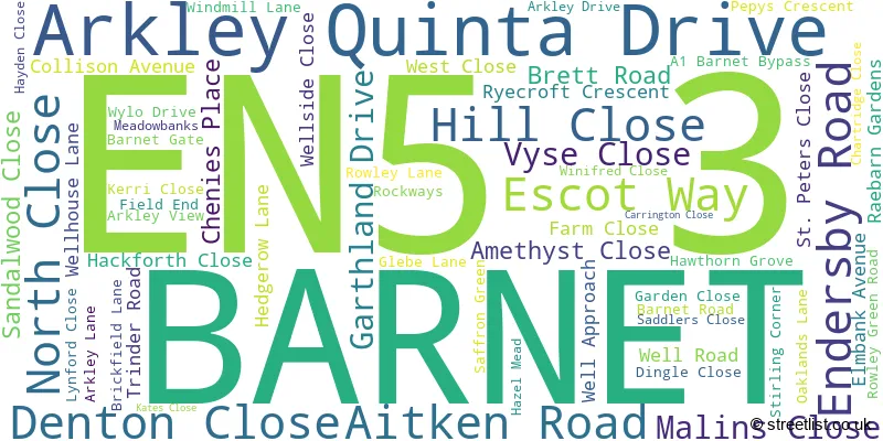
The largest settlement in the EN5 3 postal code is BARNET followed by ARKLEY , and UNDERHILL .
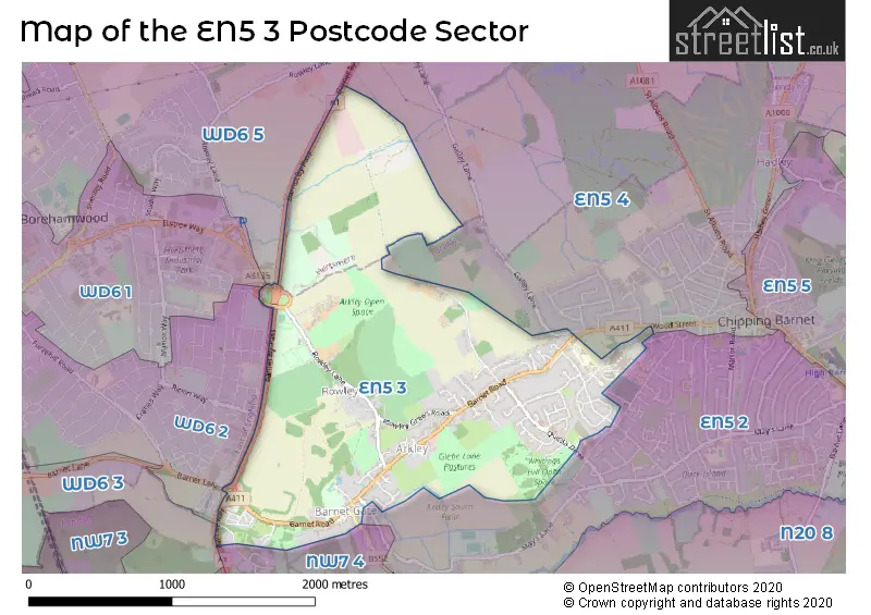
The EN5 3 Postcode shares a border with NW7 4 (MILL HILL , BARNET GATE , MARSH LANE TO TOTTERIDGE COMMON ), WD6 5 (BOREHAMWOOD ), WD6 1 (BOREHAMWOOD ), WD6 2 (BOREHAMWOOD ), EN5 2 (BARNET , UNDERHILL , CHIPPING BARNET ), WD6 3 (ELSTREE ) and EN5 4 (BARNET , DURY ROAD TO GREAT NORTH ROAD , ARKLEY BARNET SECTION ).
The sector is within the post town of BARNET.
EN5 3 is a postcode sector within the EN5 postcode district which is within the EN Enfield postcode area.
The Royal Mail delivery office for the EN5 3 postal sector is the Barnet Delivery Office.
The area of the EN5 3 postcode sector is 1.80 square miles which is 4.67 square kilometres or 1,153.41 square acres.
The EN5 3 postcode sector is crossed by the A1 Major A road.

Map of the EN5 3 Postcode Sector
Explore the EN5 3 postcode sector by using our free interactive map.
| E | N | 5 | - | 3 | X | X |
| E | N | 5 | Space | 3 | Letter | Letter |
Official List of Streets
BARNET (53 Streets)
Unofficial Streets or Alternative Spellings
BARNET
BARNET GATE LANE GALLEY LANEBarnet
BARNET WAY HENDON WOOD LANE HYVER HILL ARKLEY PARK BARNET BY-PASS BARNET FP 04 BARNET FP02 BARNET FP03 BARNET FP04 BARNET FP05 BARNET FP06 BARNET WAY (BARNET BY-PASS) BEECHCROFT ESTATES YARD FIELD VIEW PADDOCK LANE ROWLEY BANK FARM STONECROFT CLOSEBOREHAMWOOD
RIPON WAY STIRLING WAYBARNET,
ROWLEY LANEElstree
BARNET LANEWeather Forecast for EN5 3
Press Button to Show Forecast for Borehamwood
| Time Period | Icon | Description | Temperature | Rain Probability | Wind |
|---|---|---|---|---|---|
| 06:00 to 09:00 | Light rain | 6.0°C (feels like 3.0°C) | 53.00% | NE 9 mph | |
| 09:00 to 12:00 | Overcast | 7.0°C (feels like 4.0°C) | 48.00% | NE 11 mph | |
| 12:00 to 15:00 | Overcast | 9.0°C (feels like 7.0°C) | 16.00% | ENE 9 mph | |
| 15:00 to 18:00 | Cloudy | 11.0°C (feels like 9.0°C) | 14.00% | NE 9 mph | |
| 18:00 to 21:00 | Overcast | 10.0°C (feels like 8.0°C) | 22.00% | NE 11 mph | |
| 21:00 to 00:00 | Heavy rain | 9.0°C (feels like 6.0°C) | 80.00% | NE 11 mph |
Press Button to Show Forecast for Borehamwood
| Time Period | Icon | Description | Temperature | Rain Probability | Wind |
|---|---|---|---|---|---|
| 00:00 to 03:00 | Heavy rain | 8.0°C (feels like 5.0°C) | 84.00% | NNE 11 mph | |
| 03:00 to 06:00 | Heavy rain | 8.0°C (feels like 5.0°C) | 89.00% | NNE 11 mph | |
| 06:00 to 09:00 | Heavy rain | 8.0°C (feels like 5.0°C) | 86.00% | NNW 9 mph | |
| 09:00 to 12:00 | Heavy rain | 8.0°C (feels like 6.0°C) | 81.00% | NW 9 mph | |
| 12:00 to 15:00 | Heavy rain | 9.0°C (feels like 6.0°C) | 77.00% | WNW 11 mph | |
| 15:00 to 18:00 | Overcast | 10.0°C (feels like 7.0°C) | 23.00% | W 9 mph | |
| 18:00 to 21:00 | Cloudy | 10.0°C (feels like 8.0°C) | 9.00% | W 7 mph | |
| 21:00 to 00:00 | Cloudy | 8.0°C (feels like 7.0°C) | 5.00% | SW 7 mph |
Press Button to Show Forecast for Borehamwood
| Time Period | Icon | Description | Temperature | Rain Probability | Wind |
|---|---|---|---|---|---|
| 00:00 to 03:00 | Clear night | 7.0°C (feels like 5.0°C) | 2.00% | SW 7 mph | |
| 03:00 to 06:00 | Clear night | 6.0°C (feels like 4.0°C) | 1.00% | SSW 4 mph | |
| 06:00 to 09:00 | Sunny day | 7.0°C (feels like 5.0°C) | 1.00% | S 4 mph | |
| 09:00 to 12:00 | Sunny day | 11.0°C (feels like 9.0°C) | 1.00% | S 9 mph | |
| 12:00 to 15:00 | Cloudy | 14.0°C (feels like 11.0°C) | 6.00% | S 11 mph | |
| 15:00 to 18:00 | Partly cloudy (day) | 15.0°C (feels like 12.0°C) | 3.00% | S 11 mph | |
| 18:00 to 21:00 | Sunny day | 14.0°C (feels like 12.0°C) | 1.00% | S 9 mph | |
| 21:00 to 00:00 | Clear night | 11.0°C (feels like 9.0°C) | 1.00% | SSE 7 mph |
Press Button to Show Forecast for Borehamwood
| Time Period | Icon | Description | Temperature | Rain Probability | Wind |
|---|---|---|---|---|---|
| 00:00 to 03:00 | Clear night | 9.0°C (feels like 8.0°C) | 1.00% | SE 7 mph | |
| 03:00 to 06:00 | Clear night | 8.0°C (feels like 7.0°C) | 3.00% | ESE 7 mph | |
| 06:00 to 09:00 | Sunny day | 9.0°C (feels like 7.0°C) | 4.00% | ESE 7 mph | |
| 09:00 to 12:00 | Partly cloudy (day) | 12.0°C (feels like 11.0°C) | 4.00% | SE 9 mph | |
| 12:00 to 15:00 | Cloudy | 15.0°C (feels like 13.0°C) | 10.00% | SE 9 mph | |
| 15:00 to 18:00 | Cloudy | 16.0°C (feels like 14.0°C) | 12.00% | SE 9 mph | |
| 18:00 to 21:00 | Cloudy | 15.0°C (feels like 14.0°C) | 12.00% | SE 9 mph | |
| 21:00 to 00:00 | Cloudy | 13.0°C (feels like 12.0°C) | 9.00% | ESE 7 mph |
House Prices in the EN5 3 Postcode Sector
| Type of Property | 2018 Average | 2018 Sales | 2017 Average | 2017 Sales | 2016 Average | 2016 Sales | 2015 Average | 2015 Sales |
|---|---|---|---|---|---|---|---|---|
| Detached | £1,335,725 | 20 | £1,422,143 | 14 | £1,562,938 | 16 | £1,138,800 | 20 |
| Semi-Detached | £716,692 | 13 | £561,063 | 8 | £591,154 | 13 | £396,250 | 10 |
| Terraced | £627,450 | 10 | £632,800 | 10 | £427,995 | 11 | £387,175 | 8 |
| Flats | £461,112 | 40 | £473,857 | 35 | £262,300 | 5 | £260,000 | 5 |
Important Postcodes EN5 3 in the Postcode Sector
EN5 3DJ is the postcode for SPRINGWELL CENTRE, Barnet General Hospital, Wellhouse Lane, and Barnet and Chase Farm Hospitals NHS Trust, Barnet General Hospital
| The EN5 3 Sector is within these Local Authorities |
|
|---|---|
| The EN5 3 Sector is within these Counties |
|
| The EN5 3 Sector is within these Water Company Areas |
|