The TA3 6 postcode sector is within the county of Somerset.
Did you know? According to the 2021 Census, the TA3 6 postcode sector is home to a bustling 5,019 residents!
Given that each sector allows for 400 unique postcode combinations. Letters C, I, K, M, O and V are not allowed in the last two letters of a postcode. With 233 postcodes already in use, this leaves 167 units available.
The largest settlement in the TA3 6 postal code is North Curry followed by Stoke St. Gregory, and Fivehead.
The TA3 6 Postcode shares a border with TA7 0 (Westonzoyland, Middlezoy, North Newton), TA10 0 (Curry Rivel, Hambridge, Drayton), TA3 5 (Creech St. Michael, Ruishton, Henlade), TA19 0 (ILMINSTER, Shepton Beauchamp, Seavington), TA19 9 (ILMINSTER, Ilton, Horton) and TA20 3 (Combe St. Nicholas, Buckland St. Mary, Wadeford).
The sector is within the post town of TAUNTON.
TA3 6 is a postcode sector within the TA3 postcode district which is within the EX Exeter postcode area.
The Royal Mail delivery office for the TA3 6 postal sector is the Taunton Delivery Office.
The area of the TA3 6 postcode sector is 29.68 square miles which is 76.88 square kilometres or 18,997.48 square acres.
Waterways within the TA3 6 postcode sector include the River Isle, River Tone.

Map of the TA3 6 Postcode Sector
Explore the TA3 6 postcode sector by using our free interactive map.
| T | A | 3 | - | 6 | X | X |
| T | A | 3 | Space | 6 | Letter | Letter |
Official List of Streets
Wrantage (6 Streets)
North Curry (34 Streets)
Hatch Beauchamp (9 Streets)
Fivehead (14 Streets)
Stoke St. Gregory (12 Streets)
Isle Abbotts (3 Streets)
Curry Mallet (9 Streets)
Lillesdon (2 Streets)
Isle Brewers (1 Streets)
Unofficial Streets or Alternative Spellings
Hambridge
HUNDRY LANE ABBEY HILL DROVE ABBOTS WAY ABBOTTS WAY BACK LANE BARRINGTON HILL BARRINGTON HILL ROAD BATT LANE BEER STREET BELMONT ROAD BICKENHALL LANE BICKENHALL ROAD BLIND LANE BOROUGH LANE BOROUGHFIELD LANE BRADON LANE BROADBRIDGE ROAD BROADMEAD ROAD BROADWAY DROVE BROMES LANE BROOMFIELD PARK BULLPLACE BRIDGE ROAD BURTON MEAD DROVE BUSHFURLONG ROAD CAPLAND COURT CAPLAND LANE CHAPEL ROAD COLLICKSHIRE LANE COMBE LANE COPSE LANE CRICKET COTTAGES CROFT COTTAGES CROOKED DROVE CROSSHAM LANE CURLAND ROAD CURRYMOOR DROVE DAIRY HOUSE LANE DOBLE CLOSE DOWN LANE ELM BRIDGE FIELDGATE LANE FOREST DROVE FOREST DROVE NORTH FOREST DROVE SOUTH FROG LANE FROG STREET FROST STREET GAINSLOAD DROVE GARDEN PLOT HILL GRAVEL LANE GREEN LANE GRIFFIN LANE GRIFFIN ROAD GRIGGS HILL GRUGHAY LANE HANCOX FARM LANE HATCH DROVE HATCH GREEN LANE HATCH MEWS HAYMOOR DROVE HAZELTREE LANE HEADWELL CLOSE HEADWELL HILL HELLAND HILL HIGHER KNAPP LANE HIGHER KNAPP TRIANGLE HORSECROFT LANE HUNTHAM ROAD IBERRY LANE ISLE BREWERS LANE ISLEMOOR LANE ISLEMOOR ROAD ISLEMORE ROAD JUNCTION DROVE KNAPP BRIDGE KNAPP HILL KNAPP ROAD LANGFORD LANE LANGLANDS LANE LANGPORT ROAD LONGS FIELDS LOWER KNAPP LANE MEARE GREEN LANE MIDDLEROOM DROVE MILL LANE MOREDON DROVE NEW ROAD NEWPORT HILL NEWPORT ROAD NORTH DROVE OLD BARN LANE OLDMEAD DROVE OVERLAND ROAD PERMISSIVE TRACK PESTLEFIELD LANE PILE LANE PINCOMBE DROVE PITTS LANE PONDPOOL LANE POUND DROVE POUND HILL PRIORY FARM LANE RADIGAN LANE REDLAND LANE ROCK HILL ROCKWAY RODWELLS LANE RSPB PERMISSIVE PATH RSPB SWELL WOOD RUE LANE SHORT DROVE SLOUGH LANE SOLOMONS HOLLOW SOUTH DROVE ST. JAMES COURT STANMOOR MEAD DROVE STAPLE FITZPAINE ROAD STATION WORKS STAUNDLE LANE STEAMALONG STEWLEY ROAD STILLBROOK ROAD STOCKS LANE STOKE DROVE STONEHEAD HILL STOWEY LANE STREAKED LANE SWELL DROVE SWELL LANE SYCAMORE ROW VILLAGE ROAD WALRONDS PARK WEST LANE WEST SEDGEMOOR ROAD WESTFIELD LANE WIDNESS DROVE WILLOW MEAD WOODHILL ROAD WOODLANDS LANENorth Curry
MOOR LANE CLOSE MOREDONStaple Fitzpaine
NEW ROAD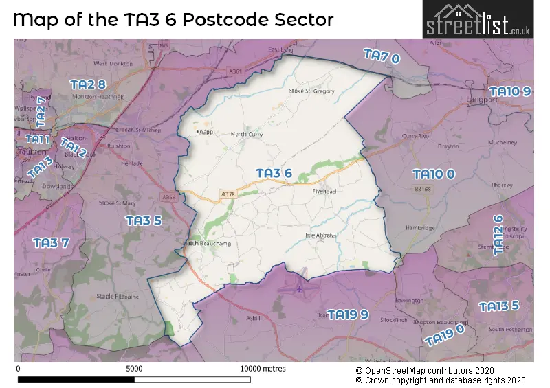
House Prices in the TA3 6 Postcode Sector
| Type of Property | 2018 Average | 2018 Sales | 2017 Average | 2017 Sales | 2016 Average | 2016 Sales | 2015 Average | 2015 Sales |
|---|---|---|---|---|---|---|---|---|
| Detached | £439,660 | 46 | £414,051 | 60 | £412,029 | 46 | £382,382 | 47 |
| Semi-Detached | £289,258 | 15 | £277,286 | 22 | £257,725 | 22 | £289,167 | 15 |
| Terraced | £247,889 | 9 | £264,278 | 9 | £228,579 | 12 | £237,857 | 7 |
| Flats | £0 | 0 | £0 | 0 | £0 | 0 | £90,733 | 3 |
Important Postcodes TA3 6 in the Postcode Sector
TA3 6EG is the postcode for Stoke St. Gregory C Of E Primary School, Huntham Lane, Stoke St Gregory
TA3 6NQ is the postcode for North Curry Village Hall, Greenway, North Curry, and North Curry Health Centre, Greenway
| The TA3 6 Sector is within these Local Authorities |
|
|---|---|
| The TA3 6 Sector is within these Counties |
|
| The TA3 6 Sector is within these Water Company Areas |
|